Tag: Airbus Defence and Space

  • More about eVTOLs

    More about eVTOLs

    Airbus is working with a team to develop a “hybrid” approach to electric aircraft, which means that their experimental aircraft is not only using electric power — with electric motors and propellors (propulsers), an 800-volt battery, and a hi-voltage distribution and control system. It also has a conventional turbine which supplies torque to a conventional propeller and generates electrical power to maintain charge for the 800-volt battery.

    Airbus EchoPulse demo aircraft. (Photo: Airbus/EchoPulse)
    Airbus EchoPulse demo aircraft. (Photo: Airbus/EchoPulse)

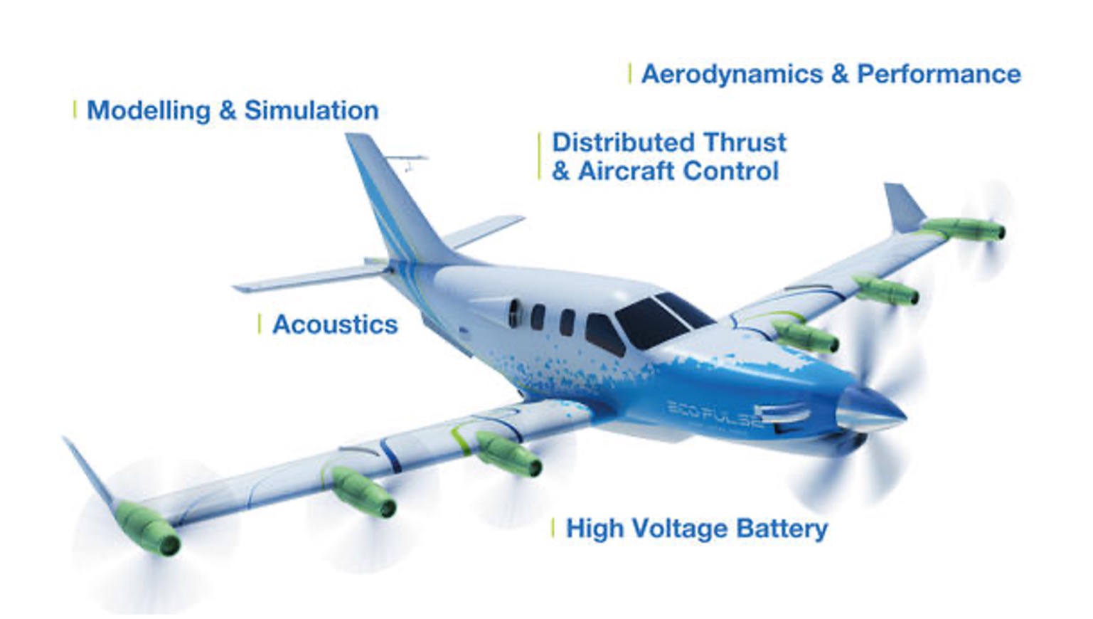
    The team working with Airbus includes Daher, which has modified its TBM 900 turboprop aircraft to add the electrical system, motors and props supplied by Safran. Airbus has developed the 800-volt battery and the Flight Control System for the aircraft, through which any future autonomous capability would likely be brought about.

    The decision to try this ‘hybrid’ approach may have been influenced by Volvo, which is pressing this approach for the Series 90 and 60 of its hybrid Electric Vehicles (EV). Combining recharging by an internal combustion engine with a battery and electric drive system greatly extends the range of this model, greatly reduces its gas consumption, and minimizes the hunt for rare recharging outlets.

    It would seem that the principal benefit from the Airbus team development could be the 800-volt DC battery design, and the high voltage distribution/control/recharging system when they are potentially spun off and applied to other manned/unmanned eVTOL passenger aircraft. The basic problem for eVTOL aircraft is payload and range – is that something that a huge energy reservoir such as this battery system could support?

    Airbus EchoPulse demo aircraft. (Photo: Airbus/EchoPulse)
    Airbus EchoPulse demo aircraft. (Photo: Airbus/EchoPulse)

    Developed by Airbus Defense and Space in Toulouse, France, the 800-volt DC battery system delivers up to 350 kilowatts to the electric system on the aircraft. The battery was derived from earlier versions that were flown on Airbus CityBus eVTOL demonstrator and FlightLab helicopters. The Lithium-ion battery weighs in at 350 kg (772 lbs.) and is mounted in an enclosure of the belly of the EcoPulse demonstration aircraft.

    Airbus reportedly plans on taking this high energy-density battery into its commercial aircraft business. But the main market could be for hybrid eVTOL aircraft, which can carry this heavy battery and its control system and to benefit from the massive energy density.

    Meanwhile, as the Russian-Ukrainian war drags on with both sides throwing at each other increasing numbers of ‘kamikaze’ UAVs carrying explosives, interest has recently been growing around a 2020 report out of St. Petersburg Electro-technical University in Russia that critiques the Russian air defense system. According to the report, these defenses are poorly adapted to detect or destroy vehicles as small and slow-moving as UAVs.

    Ukrainian UAV troops were only recently pictured assembling weaponized drones for their one-way trip to Russian-owned targets.

    Photo released by General Staff of the Armed Forces of Ukraine on Telegram
    Photo released by General Staff of the Armed Forces of Ukraine on Telegram

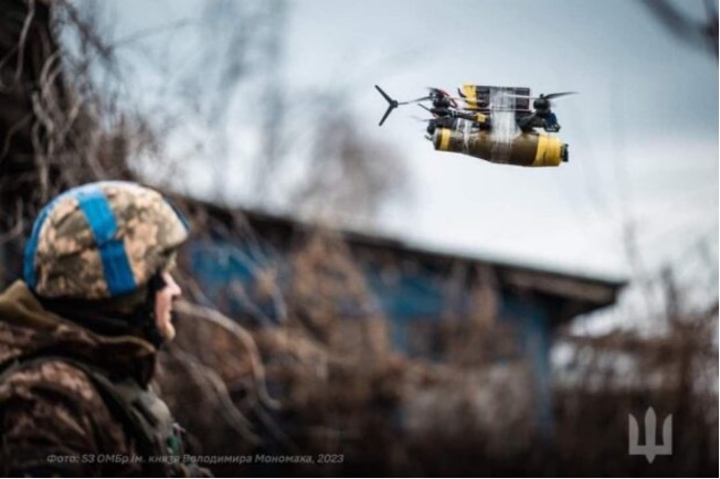
    The explosive carriers are frequently simple racing UAVs. In one released photo, an inexpensive quadcopter is taped together with plastic explosives and an RPG warhead using adhesive tape. Nothing has to be very durable, just durable enough to last for its short one-way trip through Russian defenses.

    The Russian air defenses rely on several tracked and/or wheeled mobile systems using both guns and missiles. This includes radar-guided and heat-seeking missiles, such as the Pantsir-S1, the Tunguska, the Tor, the Strela-10, and the Igla-S man-portable missiles, all of which are designed to combat high-speed jet aircraft, helicopters, and cruise missiles. At the same time, UAVs are slow and very small in comparison.

    Unfortunately, the missiles ‘ poor target detection capability and detonation control systems appear to be the culprits for the inability to strike down UAVs. Tor radar has been seen to only detect at 3-4km (1.8 -2.5 miles), while the minimum operating range is about the same. Thus, misses are reportedly more likely than taking out attacking drones. While the system may be somewhat ineffective, the cost of using missiles is huge.

    A Ukrainian UAV recording within close range of a Russian Tor defense system has captured video of a missile hurtling past and failing to bring it down. Similar results have been found with both the Pantsir-S1 and Tunguska defense systems.

    For the close-in gun and cannon defense systems, Russian tests demonstrated that to raise the probability of a direct hit to just 50% for an attacking drone at a distance of 1.3 miles, between four to 13 thousand shells would need to be fired.  This is significantly more ammunition than one Tor system can fire in one volley without reloading, even at 5,000 rounds/minute of which it is capable.

    Ukrainian war strategists continue to acquire thousands of UAVs each month, while its troops continue to throw them against their Russian invaders with improvised explosive payloads. Meanwhile, as of December 2023, Congress is continuing negotiations over another $61.4 billion in funding to further Ukraine’s war efforts, even while President Zelenskyy visited Washington to urge the U.S. to maintain its support.

    The problem with this situation is that both sides have learned that UAV warfare’ is simpler, less dangerous for the aggressor, and less costly than regular offensives. Thus, a stalemate might prolong the war for even longer.


    So, on the commercial, peaceful side of drone development, the possibility of a hybrid-electric approach for eVTOL passenger-carrying autonomous vehicles is making progress. Nevertheless, as the war continues in Ukraine, could the reduced cost of UAV warfare’ possibly prolong it?

  • Galileo second gen enters full development phase

    Galileo second gen enters full development phase

    Image: Galileo_Second_Generation.jpg
    Image: ESA

    On May 31, the European Space Agency (ESA) announced the main procurement batch of Galileo Second Generation (G2), initiated in summer 2022, has been finalized. The system is now ready for its on-orbit validation development phase.

    Following the opening session of the European Navigation Conference (ENC), Javier Benedicto, director of navigation for the ESA, invited Thales Alenia Space, Airbus Defence and Space, and Thales Six GTS  to sign contracts commencing system engineering support for the next generation of Europe’s navigation satellite system.

    Satellite-building contracts were awarded in May 2021 to Thales Alenia Space and Airbus Defence and Space to create two independent families of satellites amounting to 12 G2 satellites in total. Separate contracts were also awarded to Safran Electronics and Defence-Navigation and Timing and Leonardo to provide the ultra-precise atomic clocks carried aboard.

    Employing electric propulsion for the first time, and hosting a higher-strength navigation antenna, the G2 satellites will incorporate six (rather than four) enhanced atomic clocks as well as inter-satellite links to communicate and cross-check with one another. They will be controllable with an increased data rate to and from the ground and will operate for 15 years on orbit.

    In addition, G2’s fully digital payloads are being designed to be easily reconfigured on orbit, enabling them to respond to the evolving needs of users with novel signals and services.

    There are 28 Galileo satellites on orbit, making it the most precise satellite navigation system —providing meter-level accuracy to more than four billion users around the globe. There are 10 Galileo satellites due to be launched, after which the first of the G2 satellites with enhanced capabilities are expected to join the constellation in the next few years.

  • Galileo G2 navigation payloads begin testing

    Galileo G2 navigation payloads begin testing

    Testing on Galileo’s second-generation hardware has begun.

    Test versions of the satellites’ navigation payloads is undergoing evaluation by Airbus Defence and Space at its Ottobrunn facility in Germany and by Thales Alenia Space at the ESTEC technical center in the Netherlands of the European Space Agency (ESA).

    Known as the Galileo Payload Testbeds (GPLTBs), these are development models of the navigation payloads intended for the Galileo Second Generation (G2) satellites. The navigation antennas of the testbed payloads are being testing to check whether they meet the ambitious performance levels set for the G2 satellites.

    Instead of being assembled from space-ready components like an actual satellite payload, the GPLTBs are built from electronic parts placed in test racks, with a proof-of-concept version of a navigation antenna attached.

    “The goal with these test campaigns is to prove their design concepts early, and anticipate any technical issues that might arise as early as possible,” said Cédric Magueur, ESA’s payload manager for the Thales G2 satellites.

    “These campaigns also make it possible to develop and validate new performance measurements concepts for these new generation of complex navigation payloads,” said Dirk Hannes, ESA’s payload manager for the Airbus G2 satellites. “This will allow us to optimize the production efficiency of the flight model series.”

    The second satellite in the European Data Relay System (EDRS) undergoes tests at Airbus's Compact Antenna Test Range facility. (Photo: ESA)
    The second satellite in the European Data Relay System (EDRS) undergoes tests at Airbus’s Compact Antenna Test Range facility. (Photo: ESA)

    “Results from the testing will feed into the up-coming Preliminary Design Review for the new satellites, backing up the analyses by the companies with solid measurements,” Cédric said. “Such early testing also supports the ambitious timescale for the development and construction of G2 satellites, with the first satellites planned to reach orbit by the middle of this decade.”

    There are 26 Galileo satellites now in orbit; deployment of 12 more will begin by the end of this year. Next will come the first 12 G2 satellites, featuring enhanced navigation signals and fully digital payloads. The new generation will be made up of two independent families of satellites meeting the same performance requirements, produced by Thales Alenia Space in Italy and Airbus Defence and Space in Germany.

    Airbus Defence and Space’s GPLTB is undergoing radiated testing at the company’s Ottobrunn facility, inside a Compact Antenna Test Range (CATR). Meanwhile, the Thales Alenia Space GPLTB is about to start testing inside ESTEC’s own Hybrid European Radio Frequency and Antenna Test Zone (Hertz) chamber. The metal-walled chambers are isolated from external radio interference, with inner walls studded with foam pyramids to minimize radio-frequency signal reflections, mimicking the void of space.

    “Up until now all GPLTB testing has taken place by plugging them into test boards,” Cédric said. “These test campaigns mark the first time that their performances will be confirmed in terms of radiating signals. In our first phase we will perform near-field measurements directly around the antenna to measure all the characteristics of the signal shape, to check it matches previous conductance tests. Then, via computation, we can derive its far-field performance.”

    In the second test phase, the actual far-field measurements will be performed using another feature of the chambers, a pair of paraboloid reflectors. In this way, the signal from the testbed can be reshaped as if it had traveled the long distance that actual Galileo signals need to travel, from an altitude of 23,222 km down to Earth’s surface.

    At Airbus, the testing is being undertaken in reverse order, with the far-field measurements taking place before performing the near-field measurements.

  • France chooses Airbus fixed-wing drone for ships

    France chooses Airbus fixed-wing drone for ships

    French ministry for Armed Forces selects Airbus Survey Copter Aliaca fixed-wing drone systems to equip its ships

    Airbus Defence and Space mini UAS subsidiary Survey Copter signed a contract with French DGA Armament general directorate to provide the French Navy with 11 systems, (22 aircraft), of the electrically powered fixed-wing Aliaca maritime version UAS (officially called SMDM / “Systèmes de Mini Drones aériens embarqués pour la Marine” by French authorities), including training and integrated logistic support. First deliveries are expected in 2021.

    “We are honored to contribute to the missions of the French Navy which we will support with the highest standards of quality and reliability,” said Nicolas Askamp, head of Survey Copter/Airbus Unmanned Aerial Systems. “This new contract strengthens Survey Copter’s position as a global key player for maritime mini UAS.”

    The Aliaca maritime UAS is a high-endurance versatile system allowing up to 3 hours missions over a 50 km (27 Nm) range, perfectly adapted to maritime missions with high gyro stabilized EO/IR payload performances and qualified to operate in severe environmental conditions.

    The Aliaca SMDM is catapulted from a ship deck. (Photo: Airbus Defence and Space0
    The Aliaca SMDM is catapulted from a ship deck. (Photo: Airbus Defence and Space)

    Launched by catapult, the Aliaca maritime UAS concludes its flight by landing automatically using a dedicated net landing solution. With a length of 2,2m and a wingspan of 3,6m for a maximum take-off weight of 16 kg., the Aliaca maritime UAS benefits from a powerful yet silent electric motor. The system can be deployed easily and rapidly in less than 15 minutes by 2 operators only.

    Similarly, the user-friendly ground control station enables the operator to constantly monitor the automatic flight of the UAS while receiving in real-time day and night images and AIS (Automatic Identification System) data gathered by its on-board sensors.

    It is designed to conduct several types of missions around the ships, including increasing the understanding of the tactical situation, control of illegal operations at sea, search-and-rescue, traffic monitoring, pollution detection, tracking of any suspicious behavior in the ship environment and coastal surveillance.

    This light on-board aerial solution gives the opportunity to vessels, traditionally not equipped with aerial assets, to enhance their tactical ISR capabilities, support decision making and reactivity in operations.

    The Aliaca maritime UAS can easily be integrated on board any ships, with or without helicopter landing-deck, and its small logistic footprint enables operations and storage on board smaller sized ships. Its integration does not require heavy on-board modification nor storage of specific fuel.

    The result of 10 years of R&D investments and on-board experimentations, SURVEY Copter’s off-the-shelf Aliaca maritime UAS is a robust and resistant system to the corrosive maritime environment, an adapted solution to the electromagnetic constraints on board, and benefits from an efficient net recovery system, fully automated, meaning that no human action is required during the recovery phase.

  • Airbus to produce 3D-printed visors in fight against COVID-19

    Airbus to produce 3D-printed visors in fight against COVID-19

    Photo: Nenad Stojnev/E+/Getty Images
    Photo: Nenad Stojnev/E+/Getty Images

    Survey Copter, the tactical drones division of Airbus, will be starting production of medical protection visors using the 3D printers normally used to build drones.

    The parts produced with a 3D printer, using fused deposition modeling on an ABS type plastic base, account for up to 15% of the components of a drone built by Survey Copter, the company said. More than 20 printers are being used to produce the visors.

    The Survey Copter 3D printers take about 45 minutes to produce a visor. According to the company, they’re not certified from the outset as medical equipment but they nonetheless offer the required protection and, given the urgency, are being officially approved by the Montélimar Hospital in France.

    The challenge is to be able to produce a visor capable of withstanding the disinfection procedures used in a hospital environment at temperatures of up to 110 degrees Celsius, without deformation or opacity, the company added.

    “Providing our urgent assistance to the medical sector, faced as it is with the COVID-19 epidemic, is one of our priorities, both locally and internationally, and the reactivity of Nicolas Askamp and his teams at Survey Copter is a perfect illustration of this,” said Dirk Erat, head of communications at Airbus Defence and Space.

    In addition, Airbus in Germany joined the project. The Airbus Protospace Germany and the Airbus Composite Technology Centre in Stade, together with the 3D-printing network named “Mobility goes Additive,” are now supporting this project in Spain, also coordinating the collection and transport of visors to the Madrid region.

  • MBDA investigates GPS/GNSS-denied navigation under REASON project

    MBDA investigates GPS/GNSS-denied navigation under REASON project

    The REASON project uses satcom signals to help long-range missiles navigate. (Image: MBDA)
    The REASON project uses satcom signals to help long-range missiles navigate. (Image: MBDA)

    MBDA Missile Systems is exploring a navigation solution for long-range cruise missile systems that would use satellite communications signals to maintain precision navigation accuracies at range, reports Jane’s 360.

    MBDA told Jane’s that is has demonstrated for the first time a satcom-aided navigation as part of the Resilient and Autonomous Satcom Navigation (REASON) project. Also taking part in the project are Airbus Defence and Space and ONERA.

    REASON is part of the UK/French Materials and Components for Missiles Innovation and Technology Partnership (MCM IPT) programme, for which MBDA is the lead.

    REASON is evaluating the technical and system-level feasibility and benefits of using specialist satellite signals to aid navigation.

    For a medium-to-long duration flight, cruise missile systems require additional information to support inertial measurement unit (IMU) sensors to achieve the required level of guidance accuracy, Jane’s reported. Recent years have seen greater reliance on GPS/GNSS signals to provide navigation updates to correct IMU drift.

  • Next-generation EGNOS satellite orbited for GSA

    Next-generation EGNOS satellite orbited for GSA

    Image: GSA
    Image: GSA

    A Eutelsat communications satellite launched Oct. 9 carried a payload for the European GNSS Agency (GSA) called GEO-3. GEO-3 is a geostationary satellite designed to augment GNSS signals.

    The EGNOS payload, manufactured by Airbus Defence and Space, will hone the accuracy of satellite navigation signals over Europe for use in aviation, maritime and other industries as part of the European Geostationary Navigation Overlay System (EGNOS).

    The Eutelsat-5 West B satellite also hosts a payload that will enable service continuity for television broadcasting in Europe and North Africa.

    The GSA signed a contract in March 2017 with Eutelsat Communications for the development, integration and operation of the next-generation GEO-3 EGNOS payload.

    EGNOS operational messages are broadcast via navigation payloads on-board two GEO satellites, including an Inmarsat-3F2 satellite that is fast approaching end-of-life. The GEO-3 services replenish the EGNOS SBAS payloads, guaranteeing EGNOS availability and supporting the transition to the dual-frequency multi-constellation-capable EGNOS V3.

    Eutelsat will also develop two redundant RF ground stations to uplink the EGNOS message to the payload. It will also host EGNOS’ Navigation Land Earth Stations (NLES) in Rambouillet, France, and Cagliari, Italy, both of which will be co-located and connected to the RF ground stations.

    Proton-powered launch

    The satellite was carried aloft on a Proton rocket along with a second satellite, the Mission Extension Vehicle-1 for Northrop Grumman subsidiary SpaceLogistics, designed to service satellites. Both spacecraft were built by  Northrop Grumman.

    The Proton rocket lifted off at 6:18 a.m. Eastern Time from Russia’s Baikonur Cosmodrome in Kazakhstan. Its two passengers separated from the rocket 16 hours later in a supersynchronous transfer orbit.

    Eutelsat-5 West B is a replacement for the 17-year-old Eutelsat-5 West A satellite.

    artist's depiction, ILS/Loral
    SES-5 GEO satellite (Artist’s depiction: ESA).
  • Farmers on Climate FieldView can access satellite imagery

    Airbus Defence and Space and The Climate Corporation, a subsidiary of Bayer, have announced a global agreement to deliver frequently updated satellite imagery from Airbus to farmers through Climate FieldView, a digital agriculture platform.

    Farmers who use Climate FieldView can access high-resolution data of their fields from the Airbus SPOT 6, SPOT 7 and Pléiades satellites throughout the growing season. This gives FieldView customers the ability to more precisely monitor crop health and performance, helping them take action in the field before yield is impacted at the end of the season.

    They will also be able to visualize this satellite imagery alongside other data layers in their FieldView account, including planting and yield data, to unlock new insights about crop health.

    The large swath and coverage capabilities of the SPOT satellites enable mapping at a national level down to individual farmland parcels, while the Pléiades satellites can be used to pinpoint details in specific areas, thanks to its combination of sub-meter resolution and multispectral bands.

    The complementarity between SPOT and Pléiades resolutions, swaths and revisits is crucial for effectively monitoring crops more precisely and helps enable more-informed decision-making.

    “We are very pleased to be working with The Climate Corporation to enhance FieldView by providing them with access to updated, cloud-free images within the time frame required to efficiently monitor crops at each key growth stage,” said François Lombard, head of Intelligence Business at Airbus Defence and Space.

    “High-quality satellite imagery integrated into a farmer’s Climate FieldView account can bring in more consistent and invaluable field-level insights,” said Steven Ward, Senior Director of Geospatial and Weather Sciences at The Climate Corporation. “This partnership with Airbus supports Climate’s commitment to deliver the most robust imagery ecosystem on the farm, helping farmers make important decisions tailored precisely to their individual fields.”

    The Climate Corporation’s mission is to help the world’s farmers sustainably increase their productivity through the use of digital tools. First launched in the United States in 2015, the company’s Climate FieldView platform gives farmers a deeper understanding of their fields so they can make more informed operating decisions to optimize yields, maximize efficiency and reduce risk.

    FieldView is currently on more than 60 million paid acres across the United States, Canada, Brazil and Europe.

  • Airbus and SSC join on Pléiades Neo for Earth observation

    Swedish Space Corporation (SSC) and Airbus have signed a contract for SSC ground segment support services to the new Pléiades Neo constellation of high resolution Earth Observation satellites.

    The contract marks an important step in the long-term partnership between SSC and Airbus, and extends the capabilities of both companies.

    The first two very high-resolution Pléiades Neo satellites will be launched in mid-2020, followed by a second pair in 2022. They will join the existing Airbus constellation of optical and radar satellites, and will offer enhanced performance, and the highest reactivity in the market.

    SSC will provide comprehensive ground segment support for the Launch and Early Orbit Phase (LEOP), as well as routine on-orbit support for Telemetry, Tracking and Control (TT&C) and data reception.

    Ground Network. The core SSC ground network for Pléiades Neo will consist of the unique dual polar ground station solution of Kiruna, Sweden, and Inuvik, Canada ­— often referred to as “Kinuvik” as it is operated as a virtual single polar station.

    The partnership also includes an option to provide potentially higher data volumes at a later stage, using the southern hemisphere station of Punta Arenas, Chile.

    The optimized and highly resilient SSC ground network provides effective tasking and downloading of large data volumes more than once every orbit, enabling rapid delivery of Pléiades Neo data from anywhere on Earth.

    The ground network has been designed by SSC and Airbus to complement Airbus’ Direct Receiving Stations (DRS) as well as the Airbus SpaceDataHighway relay satellite system, while being flexible to adapt to changing seasonal needs and to give critical network diversity.

    “The Pléiades Neo constellation will be adding two million km² per day at 30-cm resolution to Airbus’ imagery offering. As tasking and downloading will be possible in every orbit, up to 60 times a day for the constellation, we need to rely on very efficient commercial polar communication services,” said François Lombard, head of Intelligence Business at Airbus Defence and Space.

    “Pléiades Neo is a cutting edge very high resolution Earth Observation constellation, and this represents a huge milestone in the close cooperation between Airbus and SSC. We are proud to be able to support Airbus in providing such critical optical imagery for the global marketplace”, said Stefan Gardefjord, CEO at SSC.

  • Airbus launches OneAtlas service for GIS imagery, data

    Airbus Defence and Space has launched The OneAtlas Platform, a collaborative environment to access premium imagery, perform large-scale image processing, extract insights and benefit from Airbus assets for solution development.

    OneAtlas is offering a 30-day free trial, giving customers streaming access to imagery, sample change detection reports, and global imagery and data layers, including the basemap and the WorldDEM.

    Besides access to a comprehensive archive with premium imagery, users can try services such as:

    • Ocean Finder for the maritime industry
    • Verde for precision agriculture
    • Starling for forest management
    • Earth Monitor for tracking changes over an area of interest

    The developer portal provides more information through  API documentation and discusses how to benefit from the imagery either in streaming or download format.

    The Ocean Finder provides a satellite-based maritime ship detection service. (Photo: One Atlas)
    The Ocean Finder provides a satellite-based maritime ship detection service. (Photo: OneAtlas)
  • Airbus and Hisdesat process first TerraSAR-X/PAZ radar interferogram

    Airbus Defence and Space and Hisdesat Servicios Estratégicos S.A. have generated the first joint TerraSAR-X/PAZ radar interferogram. This milestone demonstrates the missions’ capacity for cross-sensor interferometry, whose processing is among the most challenging.

    Interferograms are typically used to derive the topographic elevation and deformation of the Earth’s surface, and are created using at least two different images acquired at different date. This flattened cross-sensor-interferogram has been created from a mixed image pair with four days’ temporal separation acquired by TerraSAR-X and PAZ (StripMap scenes from Nov. 22-26, 2018). The area covers the oil and gas production site Burgan (Kuwait) and parts of the Persian Gulf. The oil field is the world largest sandstone oil field with the total surface area of about 1,000 km².

    As PAZ is positioned in the same orbit as TerraSAR-X and TanDEM-X and features exactly identical ground swaths and acquisition modes, they all three form a high-resolution SAR satellite constellation, jointly exploited by Hisdesat and Airbus. With the launch of PAZ, the observation repeat cycle has been divided by half, which improves the monitoring of fast ground deformation phenomena that can endanger lives and infrastructures.

    “This is a major step towards achieving the implementation of our TerraSAR-X/PAZ radar constellation,” said Hanjo Kahabka, head of production and radar constellation manager at Airbus. “The level of accuracy obtained with this interferogram is a guarantee for our customers to continue to rely on the high quality standard we have set with TerraSAR-X and TanDEM-X, but with an improved monitoring capacity,”

    “In Hisdesat we are very proud of reaching this milestone. Interferometry is one of the most technically demanding applications, and thanks to this successful joint exercise with Airbus we have not only demonstrated the top performance of our PAZ satellite but its full compatibility with TerraSAR-X and TanDEM-X,” said Miguel García Primo, CEO at Hisdesat. “Now operation in constellation can become a reality and we will be able to provide to our customers full set of images and services with the constellation.”

  • Research Roundup: Spoofing-resistant UAVs

    By Alexander Rügamer, Daniel Rubino, Xabier Zubizarreta, Wolfgang Felber, Fraunhofer IIS, and Jan Wendel and Daniel Pfaffelhuber, Airbus Defense and Space GmbH

    This work presents a new secure localization method that can be used for UAVs to obtain a new level of protection against hostile and unauthorized UAVs. While non-spreading code-encrypted (SCE) GNSS devices can be blocked, authorized UAVs using this method have unrestricted access to the non-spoofable and trusted SCE GNSS. The proposed method is to store short sequences of SCE PRN code chips on the user receiver before the mission.

    The Precalculate & Process architecture. (Images: Fraunhofer IIS)
    The Precalculate & Process architecture. (Images: Fraunhofer IIS)

    These SCE PRN code chips allow the user receiver to calculate at pre-defined points in time a secure and trustable SCE PVT position. Since no communication channel is required, this method mitigates the risk that hostile forces may try to jam the UAV’s radio control. Moreover, radio silence can be realized, which is beneficial or even required for some missions.

    No dedicated security module required on the user terminal, no SWaP problems, no keying issues, no handling of controlled items on user side, no need for a communication link giving rise to the availability and radio silence issues, and no security issues due to the short SCE PRN code chip sequences valid only for the limited mission duration and inside a limited area.

    Potential target markets for this method are police and special forces and other authorized users which are allowed to use certain SCE GNSS and would like to equip their UAVs with a secure, unspoofable positioning solution. Check out more information here.