“Seen & Heard” is a monthly feature of GPS World magazine, traveling the world to capture interesting and unusual news stories involving the GNSS/PNT industry.
Amazon sued for alleged privacy violations
Photo: Hispanolistic / E+ / Getty Images
Amazon is facing a lawsuit in Washington state, marking the first dispute under the state’s My Health My Data Act. The lawsuit accuses Amazon of violating privacy laws by collecting location data from millions of Americans without their consent through its software development kits used in various mobile applications. The collected data allegedly included information that could indicate a consumer’s attempt to acquire health services, violating the My Health My Data Act, which requires explicit consent for collecting and selling health-related data.
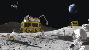
Europe’s first lunar lander underway
Photo: ESA
The European Space Agency (ESA) has partnered with Thales Alenia Space to develop Argonaut, Europe’s first lunar lander. This spacecraft will provide autonomous access to the Moon, supporting international exploration efforts. Starting in the early 2030s, Argonaut will conduct regular lunar missions, delivering infrastructure, scientific instruments, rovers and essential resources for astronauts. Designed to withstand harsh lunar conditions for up to five years, Argonaut will play a crucial role in sustainable lunar exploration, according to ESA.
Leica Geosystems, SCI-Arc equip future architects
Photo: Leica Geosystems
Leica Geosystems and the Southern California Institute of Architecture (SCI-Arc) have partnered to equip future architects with advanced technology skills. Leica is donating more than $200,000 in equipment, including lidar scanners, and offering expert guidance and scholarships to students. SCI-Arc students are applying this technology to create digital archives of Los Angeles structures and visualize rewilded wilderness.
In a recent study published by Nature Communications, researchers share that GNSS spoofing in conflict zones is disrupting wildlife tracking efforts, particularly affecting black-tailed godwits migrating through Eastern Europe. Researchers tagged 15 godwits in Finland in May 2024. Eight of these birds displayed spoofed geolocations during their migrations. The most significant spoofing occurred near Simferopol airport in Crimea, where birds were falsely located while flying over Ukraine or Romania. This spoofing added substantial errors to migration tracks, in one case creating a false 7,200-km round trip.
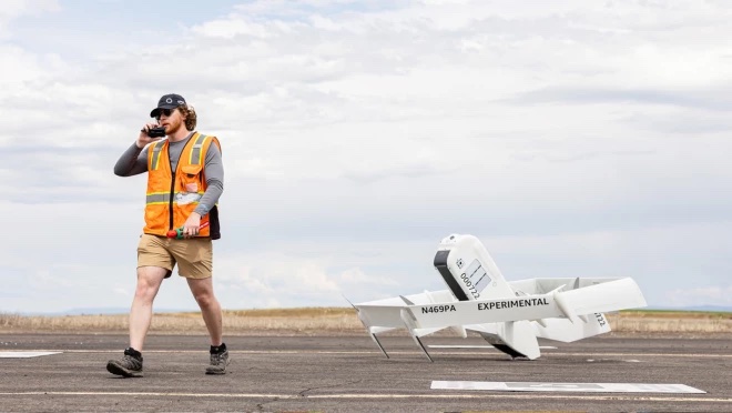
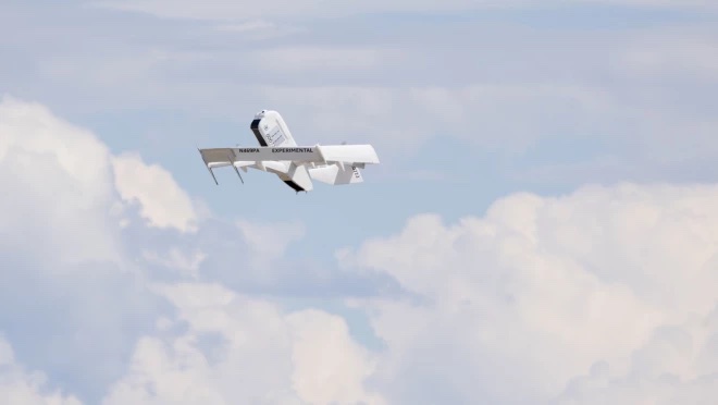
The Federal Aviation Administration (FAA) has granted Amazon Prime Air permission to operate UAVs beyond visual line of sight (BVLOS). This allows Prime Air to expand its UAV delivery service to more customers and scale operations across the U.S.
Prime Air’s BVLOS operations rely on detect-and-avoid technology, which allows UAVs to autonomously navigate obstacles for safe flight operations. Amazon provided the FAA with detailed engineering data and conducted flight demonstrations, which included real-world scenarios involving planes and hot air balloons, to validate the system’s safety.
With this FAA approval, Prime Air will extend its delivery area in College Station, Texas, using its MK-27 UAV. The service will integrate into Amazon’s existing delivery network, with UAVs deploying from facilities adjacent to same-day delivery sites.
Prime Air received an Air Carrier Certificate in 2020. The recent BVLOS approval further extends its capabilities, allowing Amazon to access more densely populated areas. The UAVs aim to deliver packages within 30 minutes or less.
Many have heard about efforts by Amazon to use UAVs for home delivery of orders within hours. Unfortunately, Amazon’s UAV trials have yet to be transitioned to “production” across the United States. Its website states that UAV deliveries are only available in College Station, Texas, and Lockeford, California.
Walmart is also in a trial phase of getting its rapid UAV delivery system working; however, its same-day UAV delivery is only servicing customers in the Tampa, Orlando, Phoenix, and Dallas areas. Nevertheless, there are many other automated deliveries underway around the world for meals and product deliveries, especially in Asia.
One segment where UAV deliveries appear to have been successful for medical samples and medications, which are now being shipped regularly on time-sensitive routes by UAVs (and, of course, several trial deliveries of these items are still underway).
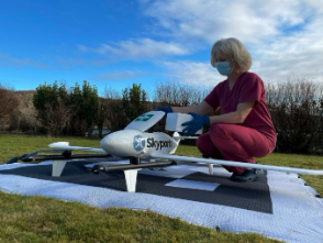
The EMED transport/courier service used extensively by the UK National Health Service took part in one of the most recent medical shipment trials — which recently wrapped up in UK — with more than 400 pathology samples being rapidly shipped by fixed-wing UAVs between two hospital sites.
Loading a UAV in a UK medical trial. (Image: ESA)
The UAV used in the EMED trial was a tried and tested Swoop Aero Kookaburra III fixed-wing aircraft with a 3kg payload that flies at 330 ft in segregated airspace.
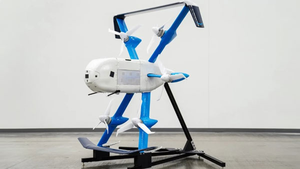
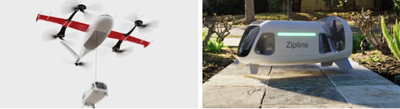
In the United States, OhioHealth aims to use a proven medical delivery system supplied by Zipline. Its plans for delivery UAVs include rapid shipments between Ohio medical facilities and prescription delivery to patients. By 2025, OhioHealth predicts that more than two million people in the Columbus area could be served by the Zipline delivery system.
OhioHealth plans to use Zipline’s Platform 2 delivery UAV — a fixed-wing carrier UAV with vertical take-off and landing (VTOL) capabilities able to autonomously hover and accurately lower a package-carrying “droid” into a tight delivery spot. The previous Zipline Platform 1 system drops packages by parachute, which requires a substantial area to receive deliveries. The “droid” has three directional fans that allow it to maneuver at the end of the tether to within six feet of the planned delivery point.
Over the last six years, Zipline has built up a whole fleet of Platform 1 aircraft and the complete infrastructure for its medical delivery operation in Rwanda.
In Rwanda, there was a need for different delivery methods to get medical supplies to hospitals, as communities are spread over large distances. Before bringing such a service to the United States, Zipline aimed to get a delivery service running, get experience, and de-bug and prove the system’s capabilities. Six years and half a million deliveries later, Zipline is now ready. For civil certification, the Federal Aviation Administration previously liked to see lots of evidence of established operational activity. Therefore, Zipline was fortunate to have six years of proven delivery activity in Rwanda when they looked to start up in the United States.
Platform 2 ‘droid’ containing a package is lowered on a tether from a hovering carrier drone. (Image: Zipline)
Zipline has also done everything needed to ensure the delivery process in Rwanda is as efficient as possible — from the order processing system, through packaging and loading into the UAV, a catapult launch system that accelerates the aircraft to climb-out speed, battery charging and exchange for each flight, autonomous navigation to the delivery point, parachute delivery at destination, autonomous return to base, and an automated capture system on arrival. As a result, it’s not unusual if a delivery can be dispatched within 90 seconds from receipt of an order.
The distances are large in Rwanda between where people are sick and where they can get help, and the necessary supplies may well be located elsewhere — at times, as much as 150 miles away. However, since Zipline deliveries became common, in-hospital maternal mortality rates have been reduced by 88% — quite an achievement. Each delivery that is dispatched really has the potential to save a life.
Now, Zipline has the potential to improve turn-round times for the health system in the United States. The company is ready to prove that the Platform 2 system makes very little noise because of specially designed propellers, that precise deliveries are possible, and it is even ready to take on regular parcel deliveries without being limited to only medical shipments.
Hopefully, some of the big retail organizations will be willing to watch, listen, trial and eventually bring the proven Zipline delivery system into their operations. There is much work to do to bring about regular UAV deliveries, but with a proven track record in Rwanda, the odds favor a successful outcome in the United States.
Sharper Shape has used SimActive software’s distributed processing capabilities to complete utility corridor base maps in Montreal, Canada. In 2022, more than eight million images were collected in SimActive’s Correlator3D software to generate orthomosaics and colorized point clouds.
Correlator3D, hosted on an Amazon cloud environment, enabled quick processing of thousands of images per day over a network of virtual machines. The resulting map products covered more than 34,000 miles of utility corridor and were imported into Sharper Shape’s artificial intelligence (AI) tools to extract infrastructure information.
“The quantity of data that we capture to feed our AI tools for utility infrastructure deliverables is incredible and comes from various geographical locations at the same time,” said Petri Rauhakallio, vice president of business development at Sharper Shape. “Correlator3D allows our teams to easily import and process massive amounts of imagery for use in our digital twin production.”
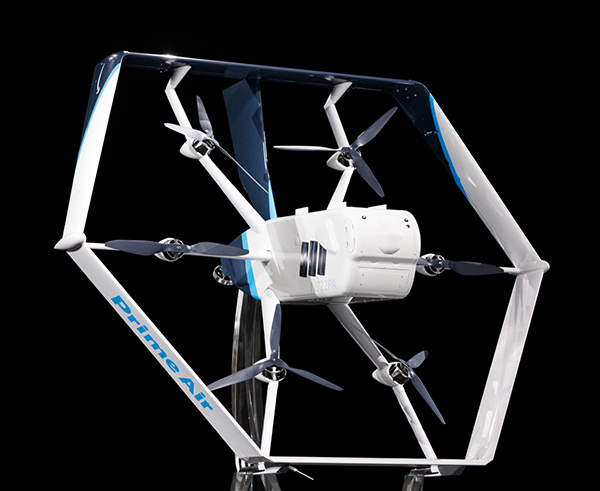
Amazon has put out a video to show how the company is building its drone delivery service. The fully electric drones are designed to deliver packages under 5 pounds to customers in less than 60 minutes.
Later this year, customers living in Lockeford, California and College Station, Texas will be among the first to receive Prime Air drone deliveries.
Three components are integral to the system:
The drone itself, which Amazon said is as robust and reliable as its ground transportation trucks.
A sense-and-avoid system for obstacles such as other aircraft, people and pets in backyards.
An automated drone-management system to plan flight paths and ensure safe distances between the drones and other aircraft in the area, and ensure compliance with aviation regulations.
Amazon has been developing its drone delivery system for almost a decade, employing experts in safety, aerospace, science, robotics, software, hardware, testing and manufacturing.
Below is an inside look at an Amazon flight-testing facility in Oregon.
Geospatial data is key to logistics, including for the huge increase in e-commerce we are experiencing following the 2020 COVID-19 shutdown.
The best customer service is if the customer doesn’t need to call you, doesn’t need to talk to you. It just works. — Jeff Bezos
This past year has been a boon for the e-commerce industry. It increased from 4% of retail sales a decade ago and pushed past 20% in 2020, reaching nearly $800 billion — a 32% jump in 10 years.
Online businesses climbed to all-time highs. A few examples stand out. Amazon’s stock increased in value 83% over the course of last year. That type of growth happens with startups and small-cap companies but is usually unheard of with large blue-chip stocks.
Along with Amazon’s growth last year, FedEx had $69 billion in annual sales. DoorDash, an e-commerce food delivery company, has a market valuation of $45 billion, making it larger than Domino’s Pizza, Texas Roadhouse and Yum! Brands combined; and Yum! Brands owns KFC, Pizza Hut and Taco Bell.
The e-commerce global trend in online sales is expected to reach $4.9 trillion in four years based on only 2.14 billion online shoppers. That is less than one-third of the world’s population. There is a lot more room to grow. This past year moved the trend several years forward.
Where are all those goods stored?
Photo: Navy Petty Officer 2nd Class Jasen Moreno-Garcia/U.S. Navy
Each consumer requires an average logistics space of 35 square feet. In the United States alone, there are more than nine billion square feet of warehouse space, and when online sales increase another 10% it will require 3 to 4 billion square feet more of space to keep up with demand.
The increase in freight driven by this trend is captured in the chart below published by the Federal Reserve, with data provided by the U.S. Department of Transportation. The blue line is increasing freight transportation services, while the red line indicates on-hand inventories.
As transportation increases and becomes more reliable — a reflection of the overall health of the logistics supply chain — the amount of on-hand inventory decreases, allowing sellers to free up space and save money, or offer greater variety knowing that stocks can readily be backfilled.
However, when inventories get too low, the system is subject to severe supply shocks, making prices more sensitive to the law of supply and demand. The grey-shaded areas on the chart are economic downturns officially recognized as recessions.
If delivery took six-to-eight weeks these days, it would signal a crisis somewhere in the world.
21st-century logistics
Goods from global corporations now arrive at each customer’s doorstep. This is 21st-century logistics. Home delivery in two days or less is the expectation. The compression of time in this industry is astounding when compared to “the way things used to be.” The way things are compared to the way things used to be reminds me of hearing my grandparents talk about life before automobiles.
Back in my day, ordering from a catalog required calling the company and speaking to a representative. The call had to be made from a corded landline, and long-distance charges might apply. If ordering a gift for someone in the household, it was difficult to be clandestine with everyone nearby. The other option was to mail in an order form. Either way, delivery took a minimum of six to eight weeks, and sometimes more. If delivery took that long these days, it would signal a crisis somewhere in the world.
Knowing where to pre-position supplies ahead of anticipated demand is a geospatial problem. Most think of this in terms of sales to customers and deliveries ahead of seasonal demands, but many countries in the world are facing this dilemma right now figuring out the best way to distribute COVID-19 vaccines. That challenge is taking place in your own community and has been a long-standing public health challenge.
Beginning in the mid-2000s, geospatial information systems (GIS) were brought in to help control outbreaks of the deadly Ebola virus. In 2014, I took a Penn State geospatial intelligence course. The final exam addressed the geospatial challenges of fighting an epidemic. Theoretically, it was difficult to get the required goods to the right place at the right time. But now, it’s not an exercise, and getting it right is not an option.
If you have received the COVID-19 vaccine, you can appreciate the pharmaceutical industry for developing vaccines in record time. However, getting the vaccines to everyone is a logistics challenge, and GIS is the unsung hero. Logistics is the life blood of empires — it is the game of kings and generals. With it, wars are won and commonwealths prosper; without it, empires crumble to dust.
How Geospatial Data Guides the Goods
Back to the traditional understanding of supply chains from seller to buyer. The needs of the buyer are simple: faster, better, cheaper. For the seller, it is much more complex, and considerations deal heavily with location.
Where is the best place to have a distribution center?
Is it more important to be close to a multi-modal transfer station, or to population centers, or are land prices more important?
What about access to highways?
What are the trade-offs in delivery times being further away from the population?
Is the trade-off worth it for the cost of land and lower taxes?
Geospatial data can answer all of these questions, even going so far as to run “what-if” scenarios.
At the local level, transportation logistics schedules the most efficient routing to deliver more packages along the shortest path. This saves time and fuel, as shown in the image below using Maptitude software. Radiuses can also be calculated based on drive times instead of distances.
Caliper truck routing software can be used for planning deliveries that account for vehicle capacities, time windows, multiple depots and more. (Image: Caliper)
Navigation routing applications are dynamic, and pick-ups are automatically routed to drivers while out on delivery runs. Dynamic routing avoids delays such as accidents and road closures.
This same type of technology is used for emergency services to respond to a call. Ambulances, police and fire trucks all use dynamic routing to get to distress calls as soon as possible.
Global transportation logistics also need to account for international laws and regulations as cargo passes through each country. These regulations can be onerous, but the logistics industry has worked out the legalities to ensure a seamless, uninterrupted flow from ship to train to airplane to truck and to final delivery. It is symbolized by the universal 40-foot international shipping container standardized throughout the world.
At each facility, inventories are tracked. Each item passing through receives a time and location stamp. Estimated delivery times are sent via text message to your mobile device or email. When the item is out for delivery, it is possible to watch it on a map as the delivery truck makes its way towards your location. When the item is delivered to your doorstep, a picture of it is sent to your phone with an alert that the package was delivered.
Only a few days earlier, the manufacturer — perhaps on the other side of the world — placed the item in a box and taped it shut; even though you ordered it in your language, the order received by the manufacturer was in their language. The package started its journey to you at the next scheduled pickup, maybe within an hour of you placing the order. Shortly afterward, your order was on a ship or an airplane. As you went about your usual business, the incredibly efficient system of e-commerce sped your package around the world to deliver it to your doorstep.
Logistics has undergone a revolution built upon the most advanced technological innovations: robotics, artificial intelligence, machine learning, mobile devices, cloud computing, electronic payment processing, and a vast geospatial framework.
In fact, it is a continuously operating, seamless, geospatial mesh running on a global scale across all time zones that allows the industry to function. Every aspect of the logistics supply chain relies upon GIS in some way, from land, air and sea navigation from global location-based systems down to inside a warehouse for storage and retrieval of merchandise. Modern-day logistics is a geospatial industry connecting goods and services to consumers, putting the GIS in lo-gis-tics.
Image: U.S. DOT
Can GIS predict the future?
Regarding whether GIS can predict a market correction… I’ll not make a prediction, but the Transportation Services Index (TSI) for March is due to be released today, May 12. If it is down from February, it would mean two months of back-to-back decline. April’s numbers won’t come out until June. However, here is an indicator of where things currently stand. The ports of Long Beach and Los Angeles, CA, the largest shipping ports in the United States is five days behind schedule, which is down from over 10 days in January.
The TSI is a leading indicator of the economy. When 20% of sales are online in a consumer-based economy, the wellbeing of the commonwealth is measured one delivery at a time.
“Trade isn’t about goods. Trade is about information. Goods sit in the warehouse until information moves them.” — C. J. Cherr
William Tewelow
William Tewelow works for the Federal Aviation Administration. He is a graduate of the FAA management fellowship program. He served on special assignment to the U.S. Department of Transportation leading a national strategic geospatial initiative for the White House Open Data Partnership. He is a Geographic Information Systems Professional (GISP) and a speaker for the Maryland STEMnet Scholar program.
He was among the first in the nation to earn a Geospatial Specialist Certification from the U.S. Department of Labor while working at NASA Stennis Space Center. He has degrees in Geographic Information Technology, Intelligence Studies, and is completing a masters degree in Organizational Management.
William is a 23 year veteran for the U.S. Navy serving as a Geospatial Specialist, Imagery Intelligence Specialist, a Naval Aviator, a Meteorologist, and a Tactical Oceanographer. He is married, enjoys writing and traveling.
His favorite quote is, “A man’s mind changed by a new idea can never go back to its original dimension.” — Oliver Wendell Holmes
Amazon’s latest delivery drone design was unveiled in June 2019. (Photo: Amazon)
Amazon has received U.S. Federal Aviation Administration (FAA) approval to use drones to deliver packages, which Amazon says will reduce package delivery time to as little as a half-hour.
The approval will give Amazon broad privileges to “safely and efficiently deliver packages to customers,” the FAA said.
Amazon joins UPS and Alphabet-owned Wing, which previously won FAA approval for their drone delivery operations.
The approval falls under Part 135 of FAA regulations, which regulates package delivery by drone. All part 135 participants must go through a five-phase process for certification.
“The FAA is encouraging innovation through the Unmanned Aircraft Systems (UAS) Integration Pilot Program (IPP) by working with industry, state, local, and tribal governments to realize the benefits of drones, while informing future rules and regulations,” according to the FAA.
“Participants in these programs are among the first to prove their concepts, including package delivery by drone through part 135 air carrier certification. Part 135 certification is the only path for small drones to carry the property of another for compensation beyond visual line of sight.”
Amazon said it will use the FAA’s certification to begin testing customer deliveries. The company said it went through rigorous training and submitted detailed evidence that its drone delivery operations are safe, including demonstrating the technology for FAA inspectors.
The U.S. Department of Transportation’s Federal Aviation Administration (FAA) announced the eight companies that will assist the federal government in establishing requirements for future suppliers of Remote Identification (Remote ID).
Remote ID will enable unmanned aircraft systems (UAS), commonly called drones, to provide identification and location information while operating in the nation’s airspace.
The FAA selected the following companies to develop technology requirements for future Remote ID UAS Service Suppliers (USS):
“The FAA will be able to advance the safe integration of drones into our nation’s airspace from these technology companies’ knowledge and expertise on remote identification,” said U.S. Transportation Secretary Elaine L. Chao.
This initial group will support the FAA in developing technology requirements for other companies to develop applications needed for Remote ID. The applications will provide drone identification and location information to safety and security authorities while in flight.
The technology is being developed simultaneously with the proposed Remote ID rule. Application requirements will be announced when the final rule is published. The FAA will then begin accepting applications for entities to become Remote ID suppliers. The FAA will provide updates when other entities can apply to become qualified Remote ID USS on FAA.gov.
Drones are a fast-growing segment of the transportation sector with nearly 1.5 million drones and 160,000 remote pilots now registered with the FAA. The agency’s ability to develop Remote ID technology simultaneously with the rule enables the FAA to continue to build on a UAS Traffic Management (UTM) system that has demonstrated global leadership through the small UAS rule and the implementation of the Low Altitude Authorization and Notification Capability (LAANC), which automates the application and approval process for most UAS operators to obtain airspace authorizations.
GeoComm is now a Select Technology Partner in the Amazon Web Services Partner Network (APN). The APN is a global program for technology and consulting customers who leverage Amazon Web Services to build solutions and services for customers.
As an APN Select Technology Partner, GeoComm will leverage Amazon Web Services to bring benefits to its customers, including security to protect the infrastructure that runs GeoComm’s cloud-based public safety GIS solutions.
In order to join the APN, GeoComm had to complete and satisfy several technical and business criteria for providing solutions and services in the APN.
According to GeoComm, this partnership will heighten its capabilities to provide easy and secure customer GIS data uploading, as well as an increased speed of GIS data updates within its customers’ dispatch mapping applications.
“Joining the APN to utilize AWS to protect the critical infrastructure of our customers mission critical solutions is a priority for GeoComm,” said Ryan Thomas, vice president of engineering and technology at GeoComm. “The APN designation exemplifies our desire to protect privacy and data security by providing cloud-based public safety GIS solutions with the highest standards.”
Founded in 1995, GeoComm provides public safety GIS software and solutions. Its GIS Data Hub solution is currently listed in the Amazon Web Services Marketplace. A number of other GeoComm solutions are being built to utilize the advanced levels of security, reliability, and scalability AWS provides, GeoComm added.
Mobile World Congress (MWC) Barcelona will still take place Feb. 24-27, despite exhibitors dropping out because of the coronavirus. According to a statement by GSMA, some large exhibitors have decided not to come to the show this year because of the coronavirus, while others are still contemplating next steps. Despite this, the show is expected to boast more than 2,800 exhibitors.
According to Reuters, as of Feb. 9, there are two confirmed cases of coronavirus in Spain.
GSMA and its partners have implemented several safety measures for attendees, the organization said, including:
Increased cleaning and disinfection across all high-volume touch points, such as catering areas, surfaces, handrails, restrooms, entrances/exits and public touchscreens, along with the use of correct cleaning/sanitizing materials and products
Increased onsite medical support
Awareness campaign via online and onsite info-share and signage
Availability of sanitizing and disinfection materials for public use
Awareness and training to all staff on standard personal preventative measures, such as personal hygiene, frequent use of sanitizing/disinfection products, etc.
Advice to exhibitors on implementing effective cleaning and disinfection of stands and offices, along with guidance on personal hygiene measures and common preventive behavior
Public health guidelines and communication with Barcelona hotels, public and private transport, restaurants and catering outlets, retail, etc.
Installing new signage onsite reminding attendees of hygiene recommendations
Implementing a microphone disinfecting and change protocol for all speakers
Communicating advice to all attendees to adopt a “no-handshake policy”
A 24-hour telephone security and medical service for all attendees, available Feb. 12 to Feb. 29. This number will appear on the back of badge holders, in the event app and on signage around the venue.
Companies Back Out
Because of the coronavirus, several companies have backed out of attending MWC Barcelona. Several of these companies include Sony, Ericsson, LG, Nvidia and Amazon.
“Due to the outbreak and continued concerns about novel coronavirus, Amazon will withdraw from exhibiting and participating in Mobile World Congress 2020,” Amazon said in a statement. According to CNN Business, the company was due to host a dozen sessions covering topics such as 5G connectivity and artificial intelligence.
Other companies have expressed similar concerns.
“Sony has been closely monitoring the evolving situation following the novel coronavirus outbreak, which was declared a global emergency by the World Health Organization on January 30,” the company said in a statement. “As we place the utmost importance on the safety and wellbeing of our customers, partners, media and employees, we have taken the difficult decision to withdraw from exhibiting and participating at MWC 2020 in Barcelona, Spain.”
As an alternative, Sony’s press release will take place on Feb. 24 via a video through its official Xperia YouTube channel.
“We’ve informed GSMA, the organizers of MWC Barcelona, that we won’t be sending our employees to this year’s event,” Nvidia said in a statement. “Given public health risks around the coronavirus, ensuring the safety of our colleagues, partners and customers is our highest concern. We’ve been looking forward to sharing our work in AI, 5G and vRAN with the industry. We regret not attending, but believe this is the right decision.”
A strategic alliance announced on Dec. 15 between Orolia and Satelles includes product development and go-to-market activities of positioning, navigation and timing (PNT) solutions provided by the Iridium satellite constellation, independent of GPS/GNSS signals. The companies intend to provide PNT solutions to military, defense, government and commercial customers worldwide.
Orolia, the parent of GNSS-active companies Spectracom and Spectratime, among others, has formed a strategic alliance, including an equity investment, with Satelles Inc. to develop, market and sell PNT solutions based on Satelles’ satellite time and location (STL) signal technology.
STL is a unique space-based PNT technology that provides location and timing data independent from traditional GPS and other GNSS satellite signals. By using STL, Orolia’s Spectracom and McMurdo solutions will, according to the company, be less susceptible to vulnerabilities such as spoofing, interference and jamming that are associated with GPS/GNSS.
Based on the low-Earth orbit (LEO) Iridium satellite constellation, STL signals are up to 1,000 times stronger than GPS/GNSS; this signal strength, due in part to the constellation’s closer proximity to users, helps to prevent jamming and enables signal reach into buildings and other difficult locations. STL’s additional cryptographic security also ensures performance, productivity and security.
For further background on Iridium, see GPS World’s June 2016 Defense PNT column, “Iridium and GPS revisited: A new PNT solution on the horizon?” Projected applications and use cases include energy/utility grids, enterprise data networks including financial systems, maritime/aviation navigation, fleet/asset tracking management, search and rescue, and data center management.
Many highly sensitive military, defense, government and commercial applications and operations require accurate and reliable PNT data. Today, these applications rely on signals from GPS/GNSS satellites. There are instances, however, where GPS/GNSS signal strength and security are not sufficient and prone to signal disruption. For these cases, the companies jointly state, STL can be used as a secure signal of opportunity to complement GPS/GNSS, making the applications more accurate and secure, and less prone to interference and attack.
“There is a growing need for precise and robust positioning, navigation and timing information especially in business-critical, high-risk and life-saving operations,” said Jean-Yves Courtois, Orolia CEO. “By augmenting Orolia’s GPS/GNSS-based solutions with Satelles’ STL technology, we will have the industry’s first essentially fail-safe, resilient PNT solution. This breakthrough offering will be ideal for mission-critical applications in which the smallest discrepancy in PNT data accuracy, availability and stability can produce a network outage, a system crash or a loss of life.”
Signal strength, availability
The technical advantages provided by adding ranging satellites in low-Earth orbit (LEO) to the GNSS satellites in medium-Earth orbit (MEO) were explored in a 2012 Institute of Navigation paper by Per Enge, Bert Ferrell, David Whelan, Greg Gutt and David Lawrence. GPS World plans to publish an updated version of that paper, with key new material on current STL performance statistics, in an upcoming issue.
Briefly, the paper concluded that “Due to their proximity, signals received from LEO are approximately 30 dB stronger than the signals from MEO. Indeed, we show data collected inside an industrial-strength metal storage container. The power of a LEO signal received inside the container is approximately equal to the power of a GPS signal received under the open sky. On the other hand, LEO proximity also dictates that only a few Iridium satellites are in view of the ground-based user. We show typical examples where six to 11 GPS satellites are joined by one or two LEO satellites.”
The authors then examine the effect of the swift mean motion of LEO satellites, analyzing the ability to whiten multipath based on the rapid motion of the line-of-sight vectors from the user to the LEO satellites. In sharp contrast to MEO, the LEO satellites attenuate errors due to multipath solely based on satellite motion, and do not require user motion. They also analyze Doppler-based positioningvusing the rapid mean motion of the LEO satellites. The Doppler shift projects onto the line-of-sight vectors from the user to the LEO satellites. Over 100 or 200 seconds, this projection is a sharp function of the user location, and this connection enables Doppler-based positioning similar to the Transit satellite system. The authors’ analysis shows that position accuracies of 5 meters can be based on noncoherent code tracking of the LEO plus GPS signals.
This paper also discusses the broadcast of UTC time to sites with known locations, describing experimental results with absolute time accuracies of one microsecond. The broadcast of high-accuracy frequency from LEO would enable a high-accuracy hot clock to replace the relatively low-quality oscillator in GNSS receivers, allowing longer coherent and non-coherent averaging times and improving the sensitivity of GNSS receivers by several decibels. Many other navigation applications would benefit from one LEO satellite in view, the authors assert.
Market view from operator’s CEO
“We are a manufacturer and integrator of timing equipment,” Orolia CEO Jean-Yves Courtois told GPS World. Orolia is the parent company of GPS/GNSS product and service providers Spectracom, McMurdo and Spectratime. “This new STL service is not fully commercialized yet, but it’s operational and it can be tested. Receivers are available and can be integrated into our equipment.
“The timing signal is very accurate and close enough to GPS for most timing applications, although the positioning accuracy is lower than what GPS users are accustomed to. It is an augmentation for timing primarily, and secondarily for positioning,” Courtois continued.
“In terms of timing accuracy, it provides on the order of tenths of microseconds in accuracy, and this covers a lot of timing applications. This is an ideal timing backup or augmentation of GPS. In positioning it’s closer to 50 meters or more, much better for fixed objects than for mobile objects. The faster the vehicle, the lower the positioning accuracy. It’s not directly usable for GPS applications that require a few meters’ accuracy, but it can be associated with inertial navigation for much better results.
“The STL signal penetrates buildings well, it has unique features, and it performs at a high level. The signal is encrypted, so you have to subscribe to a service to receive a key, allowing access to the signal. Applications are developing based on equipment that will be STL-enabled. For the user it will be transparent. The user will have a different antenna.
“We are also active in tracking and emergency location devices, where this is also of interest. It has some authentication capability, to guarantee that the person who accesses the signal is in the location that he pretends to be.
“For customers to be able to use this service, there is some integration work to be done, some dedicated STL receivers to integrate into our current hardware set up, and software modifications. We are ready to work with government and defense organizations and other new clients. Our basic interest is to add some robustness to our equipment for our current customers, and then of course to develop new customers worldwide.”
Grab It’n’Go Drive-By Shopping
Four years ago, retail giant Amazon, a leader in the elimination of human interaction, started to explore what shopping would look like if you could walk into a store, grab what you want, and leave. In early December, the company rolled out its new vision: Amazon Go.
Currently in private beta testing in Seattle and scheduled to open to the public in early 2017, the system employs a fusion of sensor technologies including RFID to detect when a shopper takes an item from the shelf, sync the data to the shopper’s handheld device, sense when the shopper leaves the store area, then charge all collected items to the shopper’s Amazon account. No muss, no fuss.
The company is keeping a tight lid on exactly how its system works, but earlier patent filings give some description of the confluence of sensor data.
“In some implementations, data from other input devices may be used to assist in determining the identity of items picked and/or placed in inventory locations. For example, if it is determined that an item is placed into an inventory location, in addition to image analysis, a weight of the item may be determined based on data received from a scale, pressure sensor, load cell, etc., located at the inventory location. … By combining multiple inputs, a higher confidence score can be generated increasing the probability that the identified item matches the item actually picked from the inventory location and/or placed at the inventory location.”
A new study from U.K.-based Juniper Research has found that annual revenues from commercial drones sales are expected to reach $481 million this year, up 84 percent from last year’s figure of $261 million.
The new research — “Drones: Consumer & Commercial Applications, Regulations & Opportunities 2015-2020” — found that a low price point had significantly reduced the barrier to entry in many sectors, with high-performance models now available for less than $3,000. It claimed that the reduction in drone price points had in turn resulted in their commercial application within an array of new fields including mapping, inspection and monitoring.
Agriculture to Lead Growth. The research argued that strongest growth would occur within the agricultural sector, which Juniper expects to account for 48 percent of all commercial drone sales this year. Here, UAVs (unmanned aerial vehicles) help save time and costs over other methods, such as walking fields on foot and using planes for fly-over filming. Furthermore, the ease of use of a UAV created for the sector allows for more regular crop surveying.
Film and Television. The research also found that demand for UAVs in the film and television sectors is soaring. Drones provide a much cheaper and more flexible alternative to the use of helicopters and other methods to capture footage for the film and TV industry, particularly for action sequences.
Delivery Drone Concerns. The research cautioned that a raft of privacy, safety and security concerns mean that the usage of drones for delivery purposes is likely to be severely constrained or even prohibited within built-up areas.
According to research co-author Windsor Holden, regulators would be extremely wary of allowing planned services such as Amazon Prime Air and Google’s Project Wing to be offered, except as a means of delivering to isolated rural communities.
“Regulators are understandably concerned that the deployment of delivery drones in inner cities would significantly increase the risk of potentially fatal collisions with cars or even pedestrians,” Holden warned.
Terrorist Concerns. The research also claimed that there was a danger that delivery drones could be hacked by terrorists, conceivably delivering an explosives payload into areas where they would be capable of causing high levels of civilian casualties.
According to Juniper Research, the report:
details and segments the various UAVs available in the market.
assesses how drone development will proceed in light of stringent safety and privacy concerns and regulatory hurdles.
analyses key market drivers, technological trends and challenges that currently influence market potential.
determines scenarios that will impact future demand.
provides in-depth forecasts across a range of key metrics.
Also, a new white paper, “Game of Drones,” is available to download from the Juniper website together with further details of the full research and the attendant Interactive Forecast Excel (IFxl).