Tag: Applanix

  • Avyon Offers Precision Mapping for Microdrones md4 Fleet from Applanix

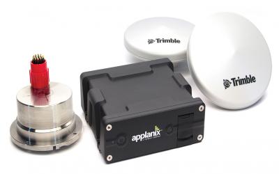
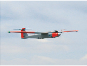
    Avyon, a sUAS (Small Unmanned Aircraft Systems) integrator and distributor, is using the Applanix APX UAV for its md4 fleet, to provide users with cost-effective direct georeferencing technology.

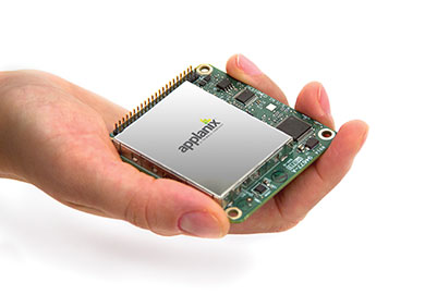
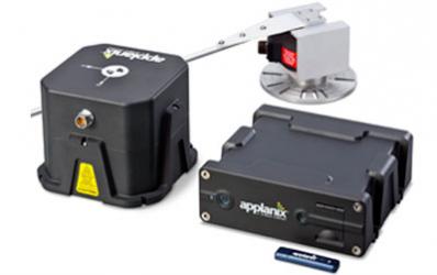
    The integration of the Applanix APX-15 UAV on the md4-1000 and md4-3000 microdrones will offer solutions for unmanned aircraft while complying with weight and size restrictions for payloads. The APX-15 works seamlessly with all other airborne sensors such as digital cameras, LIDAR and other sensors, Avy0n said.

    The APX-15 on the md4-1000 microdrone is on display at booth 1803 at the AUVSI Unmanned Systems 2015 show, being held May 4-7 in Atlanta, Ga.

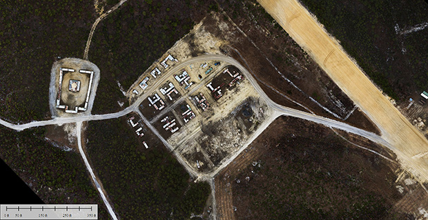
    “The integration of the APX-15 with md4-1000 and md4-3000 will provide users with a precision mapping capability, minimizing or eliminating the requirement for ground control points and making mapping missions more efficient,” said Mike Hogan, Avyon’s business development manager.

    The APX-15 UAV on the md4 fleet will improve aerial mapping by eliminating GCPs (ground control points) for triangulation, as well as reduce the amount of overlap in the surveying process. This will increase efficiency and effectiveness for area flown per mission and the post-mission data processing, Avyon said.

    “We recognize the need to provide the growing UAS mapping market with the same highly efficient solutions that we pioneered for airborne mapping over 15 years ago,” said Joe Hutton, director of Inertial Technology and Airborne Products at Applanix Corporation (xyHt pg. 14). “We are now offering a cost-effective solution that meets the size, weight, power and cost requirements of small UAS, and maintains the Applanix pedigree for quality and performance. We are pleased Avyon has partnered with us. The md4-1000 DMS-UAV is a powerful new solution.”

  • Applanix Unveils Expanded Marine Product Portfolio

    Applanix Unveils Expanded Marine Product Portfolio

    Applanix has introduced an expanded portfolio of marine georeferencing and motion compensation solutions. Taking advantage of Applanix proprietary technology, the new line-up of marine products offers high-performance solutions to a broader cross-section of the hydrographic survey industry.

    All Applanix Marine products benefit from the optimal integration of GNSS and inertial observables, with access to Trimble GNSS technology for performance advantages.

    The Applanix POS MV Surfmaster.
    The Applanix POS MV Surfmaster.

    The announcement was made at Ocean Business 2015, an exhibition of more than 300 of the world’s leading manufacturers and service providers in the industry.

    “Advances in Applanix inertial technology enable us to offer the high performance levels we are known for at even more attractive price points. By introducing this new product portfolio, we are able to deliver solutions suited to all types of bathymetric mapping,” said Peter Stewart, director of Marine Products. “This revised product lineup demonstrates Applanix’ continued commitment to provide customers with options that best fit their budget and requirements.”

    At the entry level of the expanded product portfolio, Applanix introduced the new POS MV SurfMaster. Incorporating Applanix’s proprietary SmartCal inertial calibration techniques, POS MV SurfMaster delivers robust georeferencing for small platforms, both manned and unmanned. SurfMaster is fully supported by Applanix’ post-processing software POSPac MMS, and can deliver roll and pitch accuracy to 0.03 degrees, regardless of latitude or rate of vessel motion.  

    Applanix’ new marine product lineup also includes POS MV WaveMaster II and POS MV OceanMaster. Using newly developed inertial technology, POS MV WaveMaster II delivers performance equal to the well-established and proven WaveMaster E, but at a new lower price point. POS MV OceanMaster replaces the POS MV 320 E as the georeferencing and motion compensation solution of choice for the hydrographic professional, integrating next generation inertial sensors, which enable performance and pricing previously unavailable with this class of technology. POS MV OceanMaster provides reliable and robust surveying in even the most demanding sea conditions. POS MV Elite remains the ultimate option for users seeking the highest level of performance available to the industry.

    The new POS MV SurfMaster, POS MV WaveMaster II and the POS MV OceanMaster are available now worldwide through the Applanix sales channel.

  • Applanix Offers Single-Board GNSS-Inertial System for UAV Mapping

    apx-15-in-hand
    Photo: Applanix

    Applanix, a mobile mapping and positioning company, has introduced a new product that enables major improvements in unmanned airborne mapping: the Applanix APX-15 UAV GNSS-Inertial System. The announcement was made at InterGeo, being held this week in Berlin.

    The APX-15 UAV is designed to maximize the efficiency of mapping from small unmanned aerial vehicles (UAVs) by reducing — or even eliminating — Ground Control Points (GCPs). Sidelap is also significantly reduced, increasing the area flown per mission. The Applanix APX-15 UAV provides performance in a small package and, with the included POSPac UAV post-mission software, produces a highly accurate position and orientation solution for direct georeferencing of cameras, LIDARs and other UAS sensors, the company said.

    “Applanix has recognized the need to provide the growing UAS mapping market with the same highly efficient solutions that it pioneered for airborne mapping over 15 years ago,” said Joe Hutton, Director of Inertial Technology and Airborne Products at Applanix Corporation. “We are offering a cost-effective solution that meets the size, weight, power and cost requirements of small UAS, and maintains the Applanix pedigree for quality and performance.”

    The APX-15 UAV, measuring just 6 cm x 6.7 cm and weighing only 60 grams, features a high-performance, survey-grade, multi-frequency GNSS receiver and low-noise MEMS inertial sensors all on a single board. The Applanix IN-Fusion GNSS-Inertial integration technology runs directly on the GNSS receiver, resulting in an ultra-compact design, while superior performance is achieved from the inertial sensors using the Applanix SmartCal software compensation technology.

    With 220 channels, the APX-15 UAV tracks all available GNSS satellite signals including GPS L1/L2/L2C/L5 and GLONASS L1/L2, QZSS, BeiDou and Galileo, and provides a highly accurate post-mission and real-time RTK GNSS-inertial position and orientation solution to support guidance and control, precision landing and sensor geo-referencing.

    APX-15 UAV is expected to be available worldwide in the first quarter of 2015 through the Applanix sales channel.

  • Applanix Conducts Successful Test Flight of Professional Mapping UAS

    Applanix Conducts Successful Test Flight of Professional Mapping UAS

    Applanix_UAV3

    Applanix Corporation and American Aerospace Advisors have completed a successful series of test flights of AAAI’s RS-16 platform equipped with Applanix’ DMS-UAV aerial photogrammetry payload. This is the first successful mission for a long-endurance UAS (unmanned aerial system) capable of producing professional-grade, directly georeferenced mapping imagery for civilian applications such as pipeline monitoring, power line and emergency response mapping.

    The RS-16 Unmanned Aircraft System equipped with the Applanix Direct Mapping Solution (DMS).
    The RS-16 Unmanned Aircraft System equipped with the Applanix Direct Mapping Solution (DMS).

    Tests were conducted over restricted airspace in the state of New Jersey. A joint team from Applanix and AAAI planned and flew a sequence of missions to evaluate the capabilities of the UAS. These include, critically, the ability to provide highly accurate, directly georeferenced and orthorectified aerial imagery without the need for ground control points or aerial triangulation calculations. The system, consisting of the airframe, its avionics, mobile ground control station and the digital mapping payload, performed according to expectations and successfully produced high-quality imagery.

    “Performing safe and successful missions with long endurance unmanned aircraft in civilian airspace are a challenge that goes far beyond selecting the right aircraft and payload,” said David Yoel, CEO of American Aerospace Advisors. “Working with Applanix, we have produced an integrated system that is designed from the ground up with civilian mapping operations in mind. We believe this system has the capability to transform the aerial mapping industry.”

    The Applanix R16 in flight.
    The Applanix RS-16 in flight.

    The RS-16 DMS is a complete, operational system capable of conducting large area operations within the National Airspace System in the United States, and in other jurisdictions as local regulations allow. Within the USA, AAAI is engaged with several of the recently announced UAS research and test sites, which operate under the auspices of the FAA to develop the certification and operational requirements necessary to safely integrate UAS into the national airspace.

    The GNSS-Inertial systems at the core of Applanix’ DMS-UAV aerial mapping payload uses commercial inertial technologies that are offered globally.

    “The market for airborne imaging systems is in a state of rapid change,” said Joe Hutton, director of Inertial Technology and Airborne Products at Applanix. “Developments in imaging technology, in processing capability, and in the nature of inertial sensors, make a directly georeferenced UAS a reality today, where it would have been inconceivable even a few years ago. Our ability to take our established market-leading manned solutions, and integrate the technology successfully into an unmanned platform, speaks  volumes for the engineering expertise of Applanix and AAAI.”

  • Applanix Brings Trimble CenterPoint RTX Correction Service to Airborne Mapping Products


    Applanix, a mobile mapping and positioning company, is making the Trimble CenterPoint RTX correction service available across its entire airborne mapping portfolio. Applanix is a Trimble Company.

    Using the Trimble CenterPoint RTX correction service, Applanix will be able to deliver these benefits to the aerial survey marketplace:

    • High accuracy — better than 10 cm RMS horizontal after convergence
    • Speed and low cost — no need for setting up base stations, no need to wait for delivery of public-domain ephemeris data
    • Simplicity — deal directly with Trimble (no third-party involvement)
    • More uptime and reliability — use Trimble’s professionally managed, highly maintained private network
    • Ease of use — there is no additional hardware to purchase, integrate or maintain
    • Fast and reliable convergence — 30 minutes or less to full accuracy

    The announcement was made at Trimble’s China Dimensions User Conference. The CenterPoint RTX service for Applanix airborne mapping products is expected to be available in the fourth quarter of 2013.

    “The Applanix aerial mapping portfolio is trusted throughout the aerial mapping community to provide highly accurate position and orientation information for directly georeferencing camera and sensor data,” said Joe Hutton, Director of Airborne Products at Applanix. “By integrating the Trimble CenterPoint RTX correction service, we are maintaining our position at the forefront of accuracy, robustness, and high efficiency in airborne mapping.  The CenterPoint RTX correction service gives Applanix products the  ability to achieve accuracy required for many types of mapping projects in real time and post-mission, all without the need for base stations – an industry first.”

    Trimble CenterPoint RTX correction service is a GPS, GLONASS and QZSS enabled correction service built on Trimble RTX technology.  It provides high-accuracy GNSS positioning without the use of traditional reference station-based differential RTK infrastructure.

    The solution is also compatible with the Applanix POSPac software to achieve the same level of orientation accuracy as when using base stations, all without the need to have an Internet connection or wait for precise ephemeris data to be available.

  • Applanix Adds High-Performance POS Systems to Air and Land Portfolios

    Applanix Adds High-Performance POS Systems to Air and Land Portfolios

    Photo: Applanix
    Photo: Applanix

    Applanix, a mobile mapping and positioning company, has introduced new versions of its positioning and orientation systems for airborne and land-based mapping — the POS AV 610 and POS LV 610.  Delivering the same industry-leading performance as previous versions of POS AV and LV, the new systems use next-generation commercial inertial technologies that are offered globally.

    Applanix POS AV and LV products integrate precision GNSS with advanced inertial technology (accelerometers and gyroscopes) to provide uninterrupted measurements of the position, roll, pitch and true heading of moving vehicles.  Geospatial projects using POS can be completed more efficiently, effectively and economically. The POS AV 610 and POS LV 610 offer new advantages to customers:

    • Global availability: commercial technology.
    • Smaller and lighter: achieved by integrating a new state-of-the-art FOG (Fiber Optic Gyro) based Inertial Measurement Unit (IMU).
    • Exceptional performance with Applanix SmartCalTM software:  SmartCal is a new compensation technology designed to achieve unrivalled performance from IMUs manufactured specifically for mobile mapping applications.
    • Cost efficiency: exceptional accuracy, even in demanding conditions, at unprecedented price points.

    POS LV 610 and AV 610 are also available to systems integrators in the form of an OEM board set called the Trimble AP60. The Trimble AP is a series of embedded GNSS-Inertial OEM boards that provide both continuous mobile positioning in poor signal environments and high-accuracy direct georeferencing of imaging sensors.  The AP series is ideal for a variety of commercial mobile positioning and orientation applications including airborne and terrestrial mapping and guidance for unmanned vehicles.

    “The latest versions of POS LV and POS AV take Applanix’ state-of-the-art positioning technologies worldwide for land and air applications,” said Steve Woolven, President of Applanix. “Wherever mobile mappers operate, the new POS technology provides users with  accurate, reliable and robust position and orientation solutions.”

    POS AV 610, POS LV 610 and Trimble AP60 are available now through the Applanix sales network.

  • Applanix Introduces POSPac MMS v6.2 Software for Mobile Mapping

    Applanix has introduced POSPac MMS v6.2, its latest generation of software for directly georeferencing mobile mapping sensors using GNSS and inertial technology. Featuring new Applanix IN-Fusion Multi-Single-Base Processing, POSPac MMS V6.2 is designed to improve the productivity and accuracy of mapping from mobile platforms in the air, on land or at sea, the company said.

    IN-Fusion Multi-Single-Base Processing is designed for customers who need the highest level of differential GNSS position accuracy and perform long, linear projects such as power-line corridors, long highways or stretches of coastline. During these projects, a GNSS base station network may not be available, or the geometry of the network so weak that an Applanix SmartBase solution — which uses existing reference stations to achieve high accuracy over longer distances — is not viable. In these cases, IN-Fusion Multi-Single-Base Processing allows base stations to be established along the full length of the travel path and makes optimal use of the nearest base station at all times.

    Customers can now take advantage of robust tightly coupled in-fusion processing without the need to break the project up into multiple segments for each base station to attain the highest accuracy, Applanix said.

    “In addition to IN-Fusion Multi-Single-Base Processing, POSPac MMS V6.2 includes new features designed to increase productivity, efficiency and ease-of-use.  The Coordinate Conversion tool included allows users to choose from a number of local reference frames for inputting base station coordinates,” said Edith Roy, Development Manager of POSPac MMS at Applanix.  “POSPac MMS Version 6.2 demonstrates our commitment to providing customers with not only the most advanced software solutions for mobile mapping applications, but also the easiest to use.”

    POSPac MMS V6.2 can be purchased through Applanix’ global sales network. The software is available as an upgrade to all POSPac users currently under a maintenance contract.

  • Riegl and Applanix Take Flight on UAV


    Riegl Laser Measurement Systems and Applanix Corporation announced today that the Applanix AP50 GNSS-inertial sensor system was successfully integrated with Riegl’s VQ-820-GU topo-bathymetric airborne laser scanner on board the Schiebel Camcopter S-100 UAV. The Riegl VQ-820-GU is specifically designed to survey sea beds and the grounds of rivers or lakes, and is well suited for combined land and hydrographic airborne survey.

    ap50
    Applanix AP50 GNSS-inertial system.

    The Applanix AP50 GNSS-inertial system is a GNSS-inertial sensor plus inertial measurement unit (IMU) in a compact form factor. It features a high-performance precision GNSS receiver and the Applanix IN-Fusion GNSS-inertial integration technology running on a powerful, dedicated inertial engine (IE) board.

    On board an unmanned aerial vehicle (UAV), the system is capable of penetrating areas that may be too dangerous for piloted aircraft or ground patrols. This can provide additional safety and security for its users.

    VQ-820-G_206x200px
    Riegl’s VQ-820-G airborne laser scanner.

    “We really appreciate the professional and amicable cooperation with Applanix, which allows us to offer user-friendly and powerful, fully integrated solutions for dynamic data acquisition to the marketplace,” said Jürgen Nussbaum, Riegl director of international sales.

    In addition, Applanix will be a Gold sponsor at Riegl LIDAR 2013, Riegl’s international user conference taking place in Vienna, Austria, June 25-27.