A two-kilometer free-space demonstration validates quantum-secure communications and resilient PNT capabilities
Xairos Systems has met a significant milestone for its Ares Quantum Optical Terminal, a robust system designed to deliver quantum-secure, high-data-rate communications and resilient position, navigation and timing (PNT) in RF- and GPS-denied environments.
The Ares terminal will combine 10 Gbps free-space optical communications, entangled photon distribution for timing and encryption key sharing, and a stable clock ensemble disciplined by Xairos’ exclusive Quantum Time Transfer technology.
Xairos completed two-kilometer free-space range testing with Space Development Agency-compliant optical communications and established simultaneous quantum and optical links using a common Ares Quantum Optical Terminal. This free-space testing — distinct from fiber-based demonstrations — marks a critical step toward real-world operational deployment.
The fully integrated Ares Quantum Optical Terminal will combine 10 Gbps free-space optical communications, entangled photon distribution for timing and encryption key sharing, and a stable clock ensemble disciplined by Xairos’ Quantum Time Transfer (QTT) technology — all within a ruggedized compact package. QTT provides unprecedented security and resilience for PNT where GPS and RF signals are unavailable or jammed.
The Ares Quantum Optical Terminal underpins a communications and PNT mesh network for aircraft, uncrewed aerial systems (UAS), ships, and other assets in contested environments, and serves as a foundation for a future space-based architecture spanning satellites, air vehicles and ground nodes.
Developed for a U.S. Army Program of Record, the TRX DAPS GEN II solution provides warfighters with a resilient, trusted source of position, navigation and timing (PNT) that remains operational in GPS-degraded, jammed or denied environments.
The new enhancements strengthen DAPS GEN II system performance in extended-duration threat environments and include a new mounted capability that facilitates vehicle integration.
The new mounted capability delivers a modular, open architecture that expands client support and provides future extensibility while leveraging the core DAPS GEN II capability. To facilitate use of DAPS GEN II in vehicles, a vehicle interface adapter (VIA) is under development to provide the following capabilities:
Hold the DAPS GEN II device securely in the vehicle, enabling improved inertial performance under threat
Accept and condition power from the vehicle, extending battery life
Extend the number of supported clients, enabling vehicle systems to consume a single assured-PNT feed
Provide RF and data interfaces to anti-jam antennas, enabling tight integration with the antennas, including sharing of electronic warfare situational awareness information
Provide a FLEX-IO port, enabling extensibility by supporting addition of new PNT sensors and simplifying transition of new assured PNT capabilities
JNC 2026 attendees can visit the TRX team in Booth #319 to learn how the DAPS GEN II solution supports dismounted and mounted operations by delivering continuous, assured PNT – even in contested environments.
During the conference, TRX leaders will participate in technical sessions where they will discuss the latest DAPS GEN II innovations and share testing results for delivering assured PNT in both dismounted and mounted situations:
Session C6 (Tuesday, 11:30 a.m.): Speakers from TRX Systems and Combat Ready PNT will present U.S. Army Program of Record: DAPS Gen II Advancements, Interoperability, and Performance. This presentation will review DAPS GEN II innovations that increase resilience to extended-duration threats.
Session C6: TRX Systems is supporting an alternate presentation,U.S. Army Program of Record DAPS Mounted ECP (DME). This presentation will cover the functionality being developed with the VIA and provide results from the development and testing.
Project Manager Positioning, Navigation and Timing (PM PNT) has announced the Army Contracting Command – Aberdeen Proving Ground award of two Other Transaction Authority (OTAs) via a C5 prototyping project for a mounted PNT NorthStar solution to IS4S and GPS Source.
With an estimated value of up to $41 million and 36-month period of performance, the OTAs enable the selected vendors to develop next generation of mounted Assured PNT capability that’s modular and upgradable for Army 2040 ground-based platforms.
“We’re excited to move into the next phase of NorthStar with this award,” said Chris Jais, project manager, PM PNT. “We’re confident that with our vendor partners, we’ll introduce an affordable, MOSA-compliant product with next-generation capability into our family of open solutions and continue to bring upgradable and scalable APNT products to soldiers in the field.”
PM PNT’s Modernization product office introduced the NorthStar effort in August 2023 via a virtual event and release of an RFI that received 27 vendor responses. These responses informed PM PNT’s decision to solicit industry for the design of tiers of capability that would offer a range of non-radio frequency technologies to outpace the threat of Army 2040; the responses, combined with tech evaluations and review of white papers, also led to the organization deciding to ultimately award a NorthStar OTA to more than one vendor.
“Awarding to multiple vendors encourages competition, speeds up implementation and integration of new technology to meet emerging threats, and reduces cost of engineering change proposals,” said Erik Scott, product manager for PNT Modernization. “Prioritizing a modular system design for hardware and software ensures the best value for the government and the best solution for our warfighters.”
Contract kickoffs with each vendor are scheduled for next month with design review and a soldier touchpoint to follow.
For more information on PM PNT, visit the PM PNT page on the Capability Program Executive Intelligence and Spectrum Warfare website.
A second MOU was signed with Elistair to introduce tethered unmanned aerial systems into Milanion’s ground and maritime architecture.
The agreements focus on maintaining operational capability in environments affected by electronic warfare, GNSS denial, jamming, spoofing and cyber interference, with technical integration work scheduled to begin after the exhibition and demonstrations planned for later in 2026.
The agreement with NovAtel covers land, maritime and air domains and focuses on operations in contested environments where electronic warfare, GNSS denial and cyber interference are present.
Milanion linked the partnerships to requirements raised by defense delegations at WDS 2026 for unmanned systems that remain operational without dependence on vulnerable networks and that support sovereign-ready integration.
Technical integration discussions with both companies are scheduled to begin immediately after the exhibition. Joint development pathways and capability demonstrations are planned later in 2026 as part of a broader connected autonomy architecture.
Milanion Group was founded in 2020 and is headquartered in the UK, with manufacturing in Abu Dhabi. The company develops autonomous and optionally manned systems for military and security missions across land, sea, and air.
The MOU with NovAtel will embed NovAtel assured-PNT and anti-jam technologies into Milanion assets to maintain navigation accuracy and mission integrity during GNSS denial or interference. The integration supports secure routing, guidance stability, and targeting precision even when GPS signals are degraded or disrupted. This capability is relevant for unmanned ground vehicles, maritime conversions, and airborne systems operating in electronically contested theatres. Milanion links the functionality to survivability and operational continuity during electronic warfare and cyber-disruption scenarios.
By combining assured navigation with persistent ISR and resilient communications, the company aims to maintain autonomous mission performance across multi-domain deployments. The approach integrates sensing, navigation, and communications into a unified architecture to address contested-environment requirements identified at WDS 2026.
Position, navigation and timing (PNT) services, derived primarily from GNSS constellations, have become a critical element underpinning the global economy, with a vast range of sectors depending on these signals.
This includes coordinating financial transactions, stabilizing power grids as well as navigation, with supply chains set to become more reliant on the technology as autonomous vehicles become prevalent. However, GNSS is a vulnerable technology, with faint signals from medium-Earth orbit (MEO) satellites being susceptible to disruption.
In this article we’ll look at how both static and dynamic applications can achieve resilient PNT, with strategies and sensor fusion techniques that allow operational capability when GNSS is denied.
Seven hundred. That’s the number of GPS interference events such as jamming and spoofing that take place every single day, according to the U.S. government. And this number is increasing across North America and Western Europe, with it being especially prevalent in or near war zones.
Indeed, in August, the navigation system of a plane carrying the EU President, Ursula von de Leyen, was reportedly targeted by a GPS jamming attack as it was due to land in Bulgaria — forcing pilots to rely on paper maps. And GPS interference has been linked to the crash of Azerbaijan Airlines flight J2-8243, which was shot down on Christmas Day, 2024.
Relying on a single source for PNT is no longer a viable strategy and developing a resilient PNT ecosystem that can function in D3SOE (denied, degraded, and disrupted space operational environments) has become essential.
While navigation is the most commonly understood application of PNT, the timing component is critical in so many of the static systems we rely on — not just finance and power (as listed above) but for AI data centers, asset tracking systems and communication networks — which require precise and stable time references to ensure data integrity, and need these to be synchronized across global networks.
For such systems, the consequences of getting timing off by even the smallest amount can be seen in the 2016 decommissioning of the SVN23 GPS satellite. During this, a software error created a 13.7 microsecond anomaly across the entire constellation that, according to a UK government report caused issues with digital radio broadcasts and communication networks. The event is also seen by some as a warning for the financial sector and in particular for high-frequency trading (HFT), where trades take place in millionths and studies have suggested that a 1 ms advantage in trading applications could be worth $100 million a year to a major brokerage firm.
By subtly altering timing signals used by trading systems, malicious actors can effectively see and use market data “from the future” and enact transfers worth billions of dollars.
Similarly, a timing attack on the phasor measurement units (PMUs) used to measure real-time stress in power grids could trigger major blackouts. The effect of such an attack can be seen in 2003’s (pre-PMU) Northeast Blackout, in which a sagging power line touched tree and caused a series of cascading outages that affected 55 million people across the U.S. and Canada.
And further putting the importance of protecting PNT in context, in 2020 the U.S. defined 16 critical infrastructure sectors as part of its Executive Order 13905. Of these 14 (88%) of these are reliant on PNT for their safe operation. Going beyond the energy and finance examples above, this includes sectors like communications, transportation, and agriculture. In short, PNT resilience is essential across virtually the entire economy.
Detecting a Compromised GNSS Signal
Of course, the first stage in protecting a PNT signal is in the identification of an attack, and several techniques can be used to identify inconsistencies that point to jamming or spoofing.
These range from the analysis of the signal’s Doppler shift (transmissions from nearby terrestrial spoofer will have a near-zero Doppler shift) to techniques like RAIM (receiver autonomous integrity monitoring), which continually recalculates position while excluding one satellite each time to see if the results are consistent.
Cryptographic methods, such as Galileo’s Open Service Navigation Message Authentication (OSNMA), are also available to verify a satellite’s digital signature and confirm the data’s authenticity.
However, relying on cryptographic authentication alone still comes with risks. Notably, authenticated signals are susceptible to meaconing attacks, where a legitimate signal is recorded and replayed later to mislead a receiver. It is, however, possible to counter these attacks using a secure, out-of-band verification layer for all GNSS constellations. This involves the independent delivery of authentication data with hash authentication transmitted via encrypted L-band correction signals from geostationary (GEO) satellites.
This approach can also be retrofitted to older equipment using PNT by using an RSR transcoding device (see below).
For dynamic systems, an additional level of validation can be gained by inertial sensors, comparing their output against PNT data to detect both sudden large jumps in position and continual slight deviations that can be characteristic of a sophisticated spoofing attack.
Timing in Static Applications
The timing architecture of such systems must go beyond simply identifying a threat and validate incoming data. This requires the integration of alternative PNT sources through an intelligent sensor fusion framework. To achieve this level of resilience in a fixed location, a multi-source, zero-trust approach is necessary. This involves augmenting or replacing GNSS with a layered defense of terrestrial and alternative space-based signals that can be authenticated and trusted.
Modern PTP grandmasters utilize the latest sub-microsecond accuracy Precision Time Protocol (PTP) and the more common millisecond-range Network Time Protocol (NTP) to ensure compatibility with nearly all standard IT equipment.
High-speed 25G PTP Ethernet connections are also being implemented to support high-performance AI data centers and financial exchanges without creating data bottlenecks. To ensure continuous operation during extended GNSS outages, these systems can draw synchronization from terrestrial sources like a network PTP feed or an optional atomic caesium clock.
Furthermore, it is also possible to use encrypted L-Band signals from geostationary (GEO) satellites, such as those from Inmarsat, which create an enhanced timing service with built-in GNSS authentication and anti-spoofing features to deliver timing accuracy of sub-5 ns.
Figure 1: VIAVI’s Inertial Labs division has developed a Visual-Inertial Navigation System (VINS) that combines 3D vision aided mapping with inertial accelerometers to enable positioning in D3SOE environments — shown in prototyping stage.
Navigation Without a North Star
While static applications can utilize fixed terrestrial infrastructure for backup, dynamic systems do not have this luxury.
The inherent weakness of RF signals makes them easy to overpower through deliberate jamming by hostile actors. As such, navigation systems onboard UAVs and autonomous vehicles, as well as manned commercial and military vehicles require self-contained navigation capabilities that can function reliably when GNSS signals are compromised. This has driven significant advances in inertial navigation.
Sensors like accelerometers and gyroscopes have become a critical source for orientation and direction data that remains available at all times. The development of micro-electromechanical systems (MEMS) has been crucial, enabling the integration of inertial navigation into even the smallest systems.
These sensors aren’t an alternative to PNT satellites. By their very nature they will accumulate errors over time, with sensor bias causing drift and random-walk deviations allowing random noise in each measurement to accumulate. However, recent years have seen significant gains in their accuracy, allowing navigation to continue for short periods after GNSS data is compromised.
Combining these inertial sensors with sensor fusion techniques also allows each element in a multi sensor system (using magnetometer; and accelerometers/ gyroscopes for roll, pitch and yaw…) to be continually verified by the others for further improvements in accuracy, reducing overall level of error. Data from these IMUs can also be fused with signals from alternative satellite constellations like those in LEO.
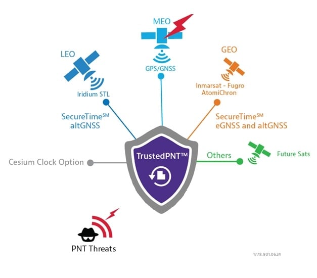
LEO satellite signals are less accurate for timing than GNSS (around 80 ns vs. sub-15 ns) but are significantly stronger. For example, the Iridium LEO STL signal is c.1,000 times stronger than GNSS, making these signals both more resistant to jamming and harder to undertake a (successful) denial of service.
More recently, techniques using downward-facing camera to track fixed identifiable landmarks have been developed as an alternative / additional data validation method for dynamic systems.
These external sources provide absolute reference points that can be used to correct the inertial system’s calculations, dramatically improving accuracy and enabling reliable navigation for much longer periods.
Figure 2: VIAVI’s SecureTime uses GEO and LEO constellations to provide positioning and timing signals that are resilient to attacks.
Sensor Fusion Gives Resilience
The limitations of individual PNT sources — whether the vulnerability of GNSS or the inherent drift of inertial sensors — mean they cannot depend on a single technology. The most effective strategy is often a hybrid one, combining a high-accuracy inertial sensor unit with inputs from other sensors.
As we touched on above, adding data sources improves the ability to detect and counter PNT attacks. For example, the EU has confirmed it will deploy additional LEO satellites to bolster its ability to detect GPS interference. And vision cameras can also be used as part of a Visual-Aided Inertial Navigation System (VINS), which provides a powerful method for maintaining an accurate position in the complete absence of GNSS signals.
This technique was developed in 2025 by VIAVI’s Inertial Labs division, with VINS combining processing with multiple inertial sensors to maintain position. This is reinforced with, and calibrated by a 3D vision-based positioning algorithm that compares visual patterns captured by an onboard camera (either daylight or infrared) with pre-loaded, satellite-imagery-derived 3D maps to track against known landmarks. In a GNSS-denied environment, a VINS system can maintain a horizontal position within 35 m, a vertical position within 5 m, and a desired velocity within 0.9 m/s.
Conclusion: Bridging the Legacy Gap
While modern systems can be designed from the ground up with a multi-layered, sensor-fusion PNT architecture, there is still the problem of the huge number of legacy systems that are very much prone to attack.
These legacy PNT systems are still widely used, including in military conflicts where D3SOE attacks are prevalent. To address this vulnerability, resilient signal retransmission technology has been developed to cost-effectively upgrade these older systems. This approach uses RSR transcoders (constellation simulators) to take a trusted PNT signal, derived from multiple assured inputs, and convert it into the standard GPS format that legacy equipment is designed to receive. This set up – in which the GNSS aerial is replaced with the input from the RSR transcoder – allows the existing systems to operate with state-of-the-art resilience without requiring replacement.
But, as we’ve seen in the above, a single, invulnerable replacement for GPS is simply not possible, so integrating multiple trusted sources is therefore essential. The path to assured PNT relies on a multi-layered ecosystem of diverse signals and sensors and applying this approach to both modern designs and legacy-system upgrades ensures all assets can maintain uninterrupted PNT access.
By Nino De Falcis, Senior Director of Business Development, ADVA
Today’s critical network infrastructure is heavily reliant on positioning, navigation and timing (PNT) services. Power grids, financial markets, transportation, data centers, communications — all have become more complex and interconnected, while the threats to the PNT on which they depend have grown in frequency and sophistication. PNT systems are so vulnerable to the activities of cybercriminals that attacks may soon become global in scale and significance, with potential costs of billions of dollars.
Utilities are a key example of infrastructure at risk. In the past, power networks were passive systems with everything simple and centralized, and with energy flowing in one direction only as AC power was provided to consumers. However, the growth in renewables and distributed energy resources has spurred diversification of the market, and a new paradigm of bidirectional AD and DC energy production and distribution has emerged: the smart grid.
Timing Challenges
Today, many smaller producers are generating power from multiple sources. The power grid has become a decentralized system and the flow of energy is now bidirectional. Energy from solar panels (microgrids), for example, can be generated by private individuals and either stored or fed back into the grid. Electric vehicles (EVs) are also becoming more common, and like all other nodes across the smart grid, charging points require precise timestamping of the massive amount of data they generate to balance power demand and supply.
Precise timing is also key to rerouting power flows away from transmission outages, to locating power line faults, and for synchronizing distributed control and protection systems. Without highly accurate timing and synchronization, power grids are vulnerable to partial outages and even complete blackouts.
That is why accuracy requirements of data timestamping are tighter than ever. In fact, they are shifting from legacy Network Timing Protocol (NTP) timestamping, which has millisecond accuracy needs, to Precision Timing Protocol (PTP) timestamping, requiring sub-microsecond accuracy. The syncrophaser now demands accuracy better than 1 microsecond.
For fault location, we’re now at 100 nanoseconds. The micro-phasor measurement unit (PMU) is at less than 1 microsecond and substation LAN communication protocols have to be time-stamped at as low as 100 microseconds for GOOSE IEC 61850 and at 1 microsecond for IEC 61850 sample values. This is a big change from just five years ago when accuracy in all these categories was firmly in the millisecond range, and it’s a high bar that needs to be maintained by next-generation redundant systems, should GPS or ground-based timing become compromised.
Guidelines for making PNT infrastructure fully redundant are being pushed by governments across the world. In the United States, regulations are being driven by Executive Order 13905 with the Department of Homeland Security (DHS) providing a framework for how assured PNT (aPNT) should operate. It states that PNT infrastructure must perform three core functions: prevent, respond and recover. Infrastructure must have the ability to prevent atypical PNT errors and corruption of PNT sources. If prevention fails, networks must be able to respond to detected errors or anomalies and then recover from those errors.
The DHS framework outlines four resiliency levels. Level 1 has only one source providing PNT, while level 4 is a next-generation system leveraging multiple sources to derive and distribute PNT data. At Level 4, systems need to be self-survivable. This means they must function for long periods in the absence of a GPS timing source, or when ground-based timing sources have been otherwise compromised. There is even an IEEE P1952 resilient PNT standard in progress that will use this DHS framework.
Rising Threats
There are two categories of threat to PNT: external and internal. External threats include jamming (equipment that can block GPS is available off the shelf for as little as $20) and spoofing, which is the act of transmitting false GPS signals that trick receivers into calculating an erroneous position. Sophisticated cyberattacks can be in the form of either of these and spoofing (especially synchronous) is the most complex to detect.
The two main internal PNT threats come from attacks on NTP and PTP network timing as well as active GPS receivers connected to the network.
Legacy power grids have traditionally used NTP to distribute timing to substations, including IRIG, and this has already shown itself to be vulnerable to attack because it can be hacked by a process called NTP amplification.
Today, power grids are increasingly migrating to PTP because it provides the sub-microsecond accuracy needed for modern applications. PTP also has not yet been hacked, but that does not mean it soon will not be. If an attack did occur on ill-prepared critical infrastructure, the results could be catastrophic.
Secure Smart Grid Timing Components
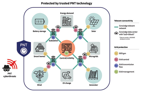
There are two components in the smart grid: telecom connectivity to transport data, and grid protection that has different level generation grid control, transmission and management. On the telecom side, there is the edge telecom network and sometimes there are data centers. There are either core or edge data centers and these are also equipped with very good timing. A key concept in the data center is time as a service and GPS backup as a service when GPS goes down. The smart grid can also leverage this service as it gives even more robust protection and security against threats to PNT. See Diagram 1.
Diagram 1. A key concept in the data center is time as a service. (Image: ADVA)
A Resilient and Assured PNT Solution
As with other aspects of cybersecurity strategy, smart grids must employ a zero-trust framework of PNT sources. This approach never assumes that any one PNT source can be trusted. Instead, it uses a multi-source approach, verifying sources and comparing them to each other in real time to get the most accurate timing possible.
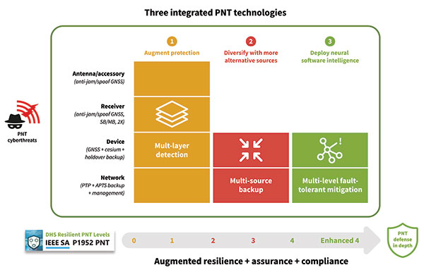
To prevent and mitigate interruptions to GPS, smart grid operators should deploy a resilient and assured PNT solution. This means it’s based around three integrated technologies: multi-layer detection, multi-source backup and multi-level fault-tolerant mitigation.
Multi-layer detection is performed through timing devices – either single or redundant – that have jamming and spoofing detection and monitoring capabilities. GNSS devices are also capable of comparing sources such as network PTP timing and they can be equipped with standalone, GNSS-backup clocks that leverage rubidium or cesium oscillators to obtain the most reliable timing information from other timing sources in the network.
Multi-source backup comes in the form of a cesium or rubidium oscillator that can provide extended holdover. Backup can be further bolstered with other sources such as eLORAN, NIST and LEO.
A neural network management system is an intelligent platform that ties everything together, from self-actionable recovery and assurance software to alerting users of issues in the network-wide timing infrastructure. It provides visibility and control of all aspects of prevention, mitigation and backup. The management system gives detailed operational data on the smart grid, showing the locations of the faults, the types of faults, and how PTP backup assurance is performing. Through capabilities powered by artificial intelligence and machine learning, the management and control system provides the end-to-end control, visibility, and trusted, assured PNT. It has all the intelligence to reveal threats and also take action against them, quickly recovering the network’s timing distribution capability, while keeping the network timing self-survivable. See Diagram 2.
Mitigating Cyberattacks with a Defense-in-Depth Approach
So, let us imagine there is a major attack on a smart grid. A jamming device has been used to block GPS reception on an edge grandmaster being used at a substation, while at the core of the network an ePRTC’s ability to receive GNSS signals has also been compromised. GPS is no longer viable as a source for timing in the smart grid.
The intelligent software monitoring and management system is the first line of defense, detecting and alerting operators to the two or more attacks on GPS: one at the core of the network and one at the substation. The network timing capability of the whole smart grid has been compromised.
Upstream from the substation, the core enhanced PRTC (ePRTC) has become an unreliable source of timing. However, it is equipped with a cesium clock that steps in to propagate trusted PNT backup into the substation and throughout the rest of the network. The cesium clock has no antenna, no RH signal, and is a stratum 1 clock that can propagate highly accurate timing (accurate to 1 microsecond over four months) throughout the network. It has now become the trusted source of timing until GPS can be re-established.
The most crucial element of PNT is timing. Without timing there is no positioning or navigation — it is the enabler of both — and so the distribution of accurate timing must be our top concern when we build systems.
For smart grids and all other critical infrastructure dependent on PNT to function, the cornerstone for secure and self-survivable timing networks is the concept of zero-trust. A multi-source approach to building timing networks will allow operators of critical infrastructure to leverage a combination of intelligent management software and timing devices equipped with adequate PTP holdover to respond to all threats to PNT.
To see a real-world example of this approach in action, check out the DOE DarkNet program.
Service providers harnessing the solution can now offer GNSS/GPS- backup-as-a-service (GBaaS) with enhanced precision and availability
OSA 3300-HP. (Photo: ADVA)
ADVA has introduced its Oscilloquartz high-performance optical cesium atomic clock. The coreSync OSA 3300-HP is ADVA’s latest innovation in assured positioning, navigation and timing (PNT).
Following ADVA’s launch of an optical pumping timing solution two years ago, the OSA 3350 ePRC+, the OSA 3300-HP takes the technology to new levels. It has a 10-year lifetime compared to the five years offered by currently available high-performance magnetic clocks.
As a high-performance optical cesium clock, the OSA 3300-HP sets a new benchmark for precision and availability, ADVA claimed, providing the resilience required for PNT assurance in critical infrastructure and empowering service providers to deliver differentiated service-level-agreement timing offerings with integrated GNSS backup.
The feature-rich device has embedded Ethernet- and IP-based management as well as a user-friendly touchscreen graphical user interface.
“The launch of our coreSync OSA 3300-HP marks a key milestone in the design of atomic frequency and phase standards,” said Gil Biran, GM of Oscilloquartz, ADVA. “After many years of extensive work in our Swiss laboratories supported by the European Space Agency, we now have a mature, state-of-the-art technology that enables a major leap in the accuracy and stability of network timing while providing a substantially longer lifetime.”
Atomic clocks offer synchronization backup for networks that rely on GNSS-based timing, combining high accuracy with outstanding availability. The OSA 3300-HP commercial high-performance optical cesium atomic clock features an all-digital design and leverages optical-pumping techniques using laser diodes. This enables it to measure 100 times the number of atoms, making it more efficient compared to existing primary reference clock (PRC) technologies.
Collins Aerospace has introduced NavHub-200M, a vehicle navigation system for the international market compatible with military code (M-code) receiver technology. The NavHub-200M is not controlled by the International Traffic in Arms Regulations (ITAR).
Collins Aerospace made the announcement at Eursatory 2022, taking place June 13-17 in Parsis.
NavHub-200M’s message formats and signal modulation techniques ensure faster and more accurate performance for ground vehicles on the connected battlespace, the company said.
NavHub-200M provides assured positioning, navigation and timing (APNT) capabilities while improving overall resistance to existing and emerging threats to GPS, such as jamming and spoofing.
“With GPS-based Selective Availability Anti-Spoofing Module (SAASM) receivers set to become obsolete, it is critical that M-Code receiver technology is made available to ground forces around the world as quickly as possible so they can trust that the signals they receive in a fast-moving, hostile environment are accurate and actionable,” said Ryan Bunge, vice president and general manager, Communication, Navigation and Guidance Solutions for Collins Aerospace. “Our NavHub-200M provides an improved resistance to jamming and interference, as well as advanced security features to prevent unauthorized access or exploitation.”
NavHub-200M also includes the open interface standards and sensor-fusion capabilities required for a GNSS upgrade path, such as that for Europe’s Galileo constellation, as well as the ability to interface with key vehicle sensors such as the inertial measurement unit (IMU) and odometer, among others.
Collins, a leader in APNT solutions for ground platforms, has delivered more than 10,000 navigation systems to military armed forced around the world.
Attendees at Eurosatory can learn more by visiting Collins Aerospace at booth number C523.
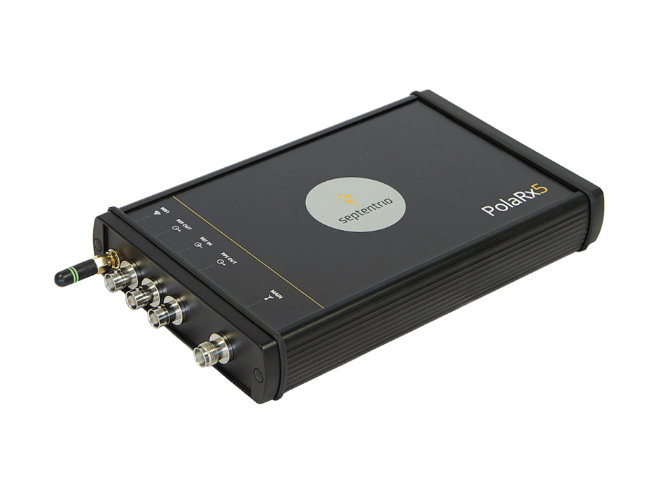
The PolaRX5 GNSS reference receiver. (Photo: Septentrio)
Septentrio, a leader in high-precision GNSS positioning solutions, has launched Open Service Navigation Message Authentication (OSNMA) on its high-end PolaRx5 reference receiver series.
OSNMA offers end-to-end authentication on Galileo’s civilian signals, protecting receivers from GNSS spoofing attacks. OSNMA adds another layer of security to Septentrio’s existing AIM+ anti-jamming and anti-spoofing technology.
This high level of resilience is especially important for reference receivers in applications that require assured PNT as well as in stationary critical infrastructure, which is especially vulnerable to GPS spoofing.
The Septentrio PolaRx5 receiver with OSNMA technology will be showcased in booth 220 at the ION Joint Navigation Conference, taking place June 6-9 in San Diego.
“We are excited to offer OSNMA anti-spoofing technology now in our scientific and reference GNSS receivers,” said François Freulon, head of product management at Septentrio. “The addition of OSNMA to Septentrio’s already strong anti-jamming and anti-spoofing technology takes our receivers to a new level as resilient positioning and timing solutions for industrial applications and critical infrastructure.”
Septentrio has also updated the PolaRx5 product range with the latest RINEX format to support version 3.05 as well as version 4.0. With these updates, PolaRx5 becomes a leading scientific and reference receiver family supporting all of the new GNSS technologies introduced in 2022, Freulon said.
The OSNMA authentication mechanism is also available on the mosaic GNSS module family and on Septentrio’s latest OEM boards.
The launch of Xona’s test satellite begins a new era of innovation in assured PNT, with NovAtel receivers demonstrating early support of Xona’s signals
Hexagon | NovAtel has signed a memorandum of understanding with Xona Space Systems to collaborate in the positioning, navigation and timing (PNT) development of Xona’s new low-Earth orbit (LEO) constellation.
LEO constellations offer a new avenue of assuring PNT by providing stronger signals with satellites closer to Earth and improved positioning accuracy with rapidly changing geometry, NovAtel explained. Additional constellations and a larger number of available satellites improve visibility in cases where parts of the sky are obstructed by buildings and other obstacles.
Also, as the threat of unintentional or malicious jamming and spoofing increases, it becomes important to consider alternative sources of PNT and resiliency methods, the companies said.
“Precise and robust PNT forms the foundation for safe operation of modern applications such as automotive and autonomy,” said Brian Manning, CEO of Xona. “We are thrilled to be collaborating with NovAtel to demonstrate the benefits that our combined technologies can bring to these markets and many more.”
Xona’s new constellation will transmit encrypted signals on two frequencies, both offering authentication, further building new levels of resilience against malicious interference. NovAtel is an early adopter of Xona’s signals and an industry leader in resilient assured PNT.
“This agreement accelerates the future of alternative PNT,” said Sandy Kennedy, vice president of innovation at Hexagon’s Autonomy & Positioning division. “Our collaboration will demonstrate the complete assured PNT ecosystem that Xona has envisioned, and of which NovAtel is very excited to be part.”
Xona and NovAtel will be presenting innovations in assured PNT and the future of GNSS at the Autonomy & Positioning Reality Summit during HxGN LIVE Global in Las Vegas, June 20-23.
Photo: U.S. Army/Spc. Brooke Davis, Operations Group, National Training Center
BAE Systems has unveiled its ultra-small MicroGRAM-M GPS receiver that receives the new M-code military GPS signals resistant to jamming and spoofing.
About the size of a postage stamp, MicroGRAM-M is a small, lightweight and power-efficient M-code embedded GPS receiver, capable of delivering assured positioning, navigation and timing (PNT) for size-constrained and other micro-applications.
“We’re delivering reliable PNT where our customers need it — from soldiers’ handheld devices to small unmanned aerial vehicles,” said Greg Wild, director of Navigation and Sensor Systems at BAE Systems. “MicroGRAM-M provides our armed forces and allies with a low-SWAP M-code GPS solution that’s resistant to adversaries’ disruption efforts in highly contested environments.”
MicroGRAM-M features rapid, secure GPS signal acquisition, enhanced security and resiliency, anti-jamming and anti-spoofing capabilities, and very low power consumption for an M-code device. The 1.0 x 1.25 x 0.275-inch MicroGRAM-M has the same physical dimensions as its predecessor, enabling quick upgradability to M-code and reduced system integration costs. At its core is a proven, tamper-proof M-code Common GPS Module that encapsulates classified data and signal processing.
“MicroGRAM-M is the latest BAE Systems M-code military GPS product, joining MPE-M and NavStrike-M, which deliver enhanced awareness in highly contested environments and precision munitions guidance,” said John Watkins, vice president and general manager of Precision Strike & Sensing Solutions at BAE Systems. “Qualification of MicroGRAM-M is underway, with full-rate production expected in 2022.”
Delivering M-code User Equipment to Germany
On June 29, BAE Systems received the first contract from the Space and Missile Systems Center’s Space Production Corps to deliver M-code military GPS user equipment to Germany. Under a Foreign Military Sales contract, the company is delivering the advanced M-code GPS technology to Germany, enabling precise, resilient, and secure geolocation and positioning capabilities that improve the effectiveness of allied operations.
The German FMS order focuses on BAE Systems’ Miniature PLGR Engine — M-code (MPE-M), which delivers precise positioning, navigation and timing capabilities; anti-jamming and anti-spoofing capabilities; a modern security architecture; and a size suitable for space-constrained applications.
BAE Systems will provide the first MPE-M receivers to Germany for integration, test and evaluation in 2021. Work on the program will be performed at BAE Systems’ facilities in Cedar Rapids and Coralville, Iowa.
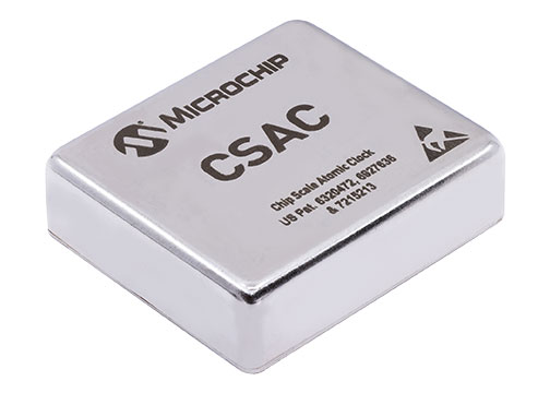
New SA65 CSAC provides wider operating temperatures, faster warm-up and improved frequency stability in extreme environments
Photo: Microchip Technology
Microchip Technology Inc. is offering the new SA65 chip-scale atomic clock (CSAC), providing precise timing accuracy and stability in extreme environments. Designed for military and industrial systems, the Microchip’s SA65 CSAC features ultra-high precision and low power consumption
Advanced military platforms, ocean-bottom survey systems and remote-sensing applications all require precise timing. CSACs ensure stable and accurate timing even when GNSS time signals are unavailable, thereby helping industrial and military system designers to meet timing requirements.
Microchip’s SA65 CSAC is an embedded timing solution with improved environmental ruggedness, delivering higher performance than the previous SA.45s CSAC, including double the frequency stability over a wider temperature range and faster warm-up from cold temperatures. The SA65 has an operating temperature range of –40 to 80 °C and a storage temperature range of –55 to 105 °C. The warm-up time of two minutes at –40 °C is 33% faster than that of the SA.45s.
These performance improvements benefit designers of highly portable solutions for military applications such as assured positioning, navigation and timing (A-PNT) and C5ISR (command, control, communications, computers, cyber, intelligence, surveillance and reconnaissance). It meets precise frequency requirements of a low size, weight and power (SWaP) atomic clock. Improvements such as fast warm-up to frequency after cold start, temperature stability over a wide operating range, and frequency accuracy and stability enabling extended operation while GNSS is denied help to ensure mission success in conflict environments.
The SA65 CSAC provides precise timing for portable and battery-powered applications requiring continuous operation and holdover in GNSS-denied environments. The SA65 is form-, fit- and function-compatible with the SA.45s, which minimizes risk and redesign costs for the system developer while improving performance and environmental insensitivity.