Successful eLoran field trial using ADVA’s OSA 5420 Series demonstrates same accuracy and stability as GPS with much-improved resilience
UrsaNav and ADVA have conducted an enhanced long-range navigation (eLoran) field trial using UrsaNav’s eLoran receiver and ADVA’s Oscilloquartz grandmaster clock technology. The successful demonstration shows that eLoran offers a robust and reliable backup for GPS and other GNSS, and could be used to provide an assured position, navigation and timing (PNT) service.
The trial follows U.S. PNT Executive Order 13905 aimed at strengthening national resilience through PNT services, including protecting critical infrastructure such as electrical power grid and communication networks from rising cyber threats. By harnessing ADVA’s flexible OSA 5420 series, designed with assured PNT (A-PNT) technology, UrsaNav has shown that eLoran can provide a new layer of protection and significantly boost timing resilience and security.
“The success of this field trial demonstrates how eLoran, as part of ADVA’s assured PNT solution, can serve as a crucial backup for GPS,” said Charles Schue, CEO, UrsaNav. “We have shown how our technology enables ADVA’s grandmaster clock to receive UTC timing from the eLoran system for a period of several days with the same accuracy and stability as GPS. Of course, this capability is extensible to other GNSS as well. eLoran is far less vulnerable to unintentional jamming and spoofing disruptions or intentional attacks, thereby delivering nanosecond precision with even more resilience.”
“By partnering with ADVA, we’ve been able to show that our eLoran receiver interoperates with the best network timing toolkit available,” Schue said. “The OSA 5420 Series is a great product — highly efficient and easy to operate. Together with ADVA, we’re paving the way for tomorrow’s more robust assured PNT synchronization architecture. Now that UrsaNav has demonstrated the power of our OSA 5420 Series to utilize eLoran in the event of outages, we have another very important tool to ensure the quality and availability of time-sensitive services.”
UrsaNav’s latest trial used the OSA 5420 series grandmaster clock with built-in GNSS receiver. Timing stability from GPS was measured for several days. This was then replaced with eLoran for the same period with no loss of stability.
The test was conducted indoors where GNSS signals are not usually available, potentially extending the availability of precise UTC timing to many more environments.
“Commercially available GNSS jammers and spoofers are easy and cheap for attackers to acquire,” explained Nir Laufer, VP, product line management, Oscilloquartz, ADVA. “That’s part of the reason why we’re seeing a growing number of incidents across the world of blocked or misleading signals. If power utilities, enterprises, service providers and governments continue to rely on GNSS alone, it’s only a matter of time before the consequences become very serious. That’s why we’re committed to tackling GNSS vulnerabilities with advanced technologies like our ePRTC offering, cesium atomic clocks and our optical timing channel solution. Now that UrsaNav has demonstrated the power of our OSA 5420 series to utilize eLoran in the event of outages, we have another very important tool to ensure the quality and availability of time-sensitive services.”
The demo showed how ADVA’s synchronization technology enables protection for critical infrastructure that needs ultra-reliable aPNT solutions. (Photo: Business Wire)
The GAJT-410MS provides anti-jamming to marine vessels. (Image: NovAtel)
Hexagon | NovAtel has released the GAJT-410MS in response to the increase of interference and jamming in marine environments worldwide. The GAJT-410MS is the company’s latest addition to its proven GPS Anti-Jam Technology (GAJT) for the commercial and defense marine markets.
The low size, weight and power (SWaP) variant protects civil and military operations from interference and jamming, with jammer direction-finding capabilities for enhanced situational awareness in the marine environment.
The GAJT-410MS provides dynamic protection on both GPS L1 and L2 bands, as well as Galileo E1, QZSS L1 and L2 and SBAS L1 to combat intentional and unintentional interference. If a vessel experiences jamming, the device’s direction-finding capabilities provide improved situation awareness of their RF environment to identify and locate the source of the jamming signals.
The commercial off-the-shelf, non-ITAR solution is easy to install or retrofit onto existing fleets, enabling assured PNT for continuous operations, cybersecurity and safe navigation at sea, NovAtel said.
Interference, both benign and malicious, is a challenge facing civilian and military operations. Commercial marine applications like shipping, tankers and bulk carriers are under threat from interference targeting their navigation and cybersecurity. Without assured positioning, these vessels can drift off-course and place the vessel, crew and cargo at risk.
Nearshore marine applications like survey, construction and piloting also require reliable positioning for uninterrupted operations in crowded waterways and RF environments. Interference mitigation and jammer direction-finding for advanced situation awareness ensure users acquire assured positioning, navigating and timing (PNT) while identifying and limiting risk from interference sources.
“Assured navigation and cybersecurity defenses are growing priorities for marine users as global threats from interference and jamming increase,” said David Russell, marine segment portfolio manager for Hexagon’s Autonomy & Positioning division. “The GAJT-410MS is an anti-jam solution protecting vessels from interference and jamming disruptions to ensure continuous operations wherever your application takes you. With GAJT, your position, navigation and timing are protected and assured.”
The GAJT-410MS is the latest iteration of proven, high-performance anti-jam products from NovAtel. It includes flexible mounting options, jammer presence and direction-finding capabilities for advanced situation awareness.
The United States Army has awarded Collins Aerospace a Phase III contract to build the second generation of its Mounted Assured Position Navigation and Timing System (MAPS).
The MAPS program adds anti-jamming capability for soldiers in GPS-contested environments. In 2019, MAPS Gen I units were installed on Stryker vehicles of the 2nd Cavalry Regiment in Germany.
Phase 3 of the MAPS Gen II program “begins combat platform integration in preparation for low-rate initial production,” according to an Oct. 7 Army press release.
MAPS Gen II includes M-code GPS receivers, provided by BAE Systems, along with anti-jamming antennas, sensor fusion and inertial measurement units to deliver assured PNT to soldiers.
MAPS Gen II is part of the Army’s goal to accelerate the development and fielding of modernized soldier capabilities.
“Less than a year after we equipped the first generation of MAPS in Europe we’re already pushing forward with the development of Gen II,” said Willie Nelson, director of the the Assured Positioning, Navigation and Timing (APNT) Cross-Functional Team (CFT). “This award comes less than a month after our Mounted APNT requirement was approved. The timing could not be better.”
MAPS Gen I includes A and B kits, consisting of cable and mounts to use on a vehicle and a military GPS paired with non-radio frequency technologies.
The Phase III Other Transaction Authority contract covers product maturation and begins combat platform integration, clearing the path to low rate initial production.
Army Stryker ground combat vehicle. (Photo: Karolis Kavolelis / Shutterstock.com)
The MAPS GEN II is comprised of the NavHub-100 PNT Distribution Device, the Multi-Sensor Antenna System (MSAS-100) and an optional speed sensor. The NavHub-100 works in concert with the MSAS-100 to produce a trusted A-PNT solution that can be distributed through serial interface, Victory Ethernet and RF distribution to multiple client systems.
MAPS GEN II supports the U.S. Army PNT Reference Architecture by leveraging modular technologies from across Collins’ A-PNT portfolio and industry. This scalable architecture builds upon the modular open system architecture (MOSA) standards and includes the All Source Positioning and Navigation (ASPN) generic message definition to support plug-and-play sensor integration and the Future Airborne Capability Environment (FACE) to host portable software capabilities.
The MAPS GEN II system not only supports direct replacement of the Defense Advanced GPS Receiver (DAGR) on military platforms, it also provides exceptional A-PNT performance in GPS-contested and GPS-denied environments.
Undersecretary of Defense Michael Griffin. (Photo: DOD)
Augmenting GPS with other systems was suggested as the most promising area of improvement in a recently released memo establishing a Defense Science Board task force on positioning, navigation and timing (PNT).
On Dec. 16, the Department of Defense released a memo from Undersecretary Michael Griffin to the chair of the Defense Science Board. In it he outlined terms of reference for a year-long study of defense “position, navigation and timing control.”
Setting the stage for the effort, Griffin, who serves as undersecretary for research and engineering, outlined some challenges of relying too heavily on GPS. “The current system has less susceptibility to jamming and spoofing, but challenges remain — slow fielding of user M-code capability, cyber and kinetic threats. Degradation can occur in canyons, cities, and high signal multipath environments.”
He also seemed to indicate that, while further improvements to GPS were possible, they would likely yield only marginal returns and be very expensive.
“While performance and resilience continue to improve, the system has matured to the point that these changes have resulted in incremental improvement to overall system performance,” Griffin said. “The cost of the system and ongoing upgrades have experienced significant growth, making it hard to increase the density of the satellites to address the more challenging environments.
The memo suggests that, rather than focusing entirely on continual improvements to GPS, adding other systems to a PNT architecture for users will likely be more effective and economical.
One such addition may well be leveraging thousands of planned commercial communications satellites to also provide PNT.
“A future multi-mission constellation that can transmit and receive RF signal[s] across a broad spectrum will allow both the ability [to] provide and deny communication and PNT globally and will provide support to all essential warfighting missions,” Griffin said.
This idea is already being explored by Army Futures Command in partnership with the University of Texas at Austin’s Radionavigation Laboratory.
Yet Griffin cautions that using commercial communications satellites may or may not be a good idea. The memo asks the group to evaluate the benefits and risks of the military depending upon commercial systems.
Reinforcing the theme of focusing on architecture, Griffin’s final question to the study group deals with “the performance and resilience benefits” of adopting other PNT sources such as portable atomic clocks, visual sensors, and terrestrial-based navigation and timing.
This parallels the recently released DoD PNT Strategy, which calls for a wide diversity of PNT sources to create an architecture for greatly increased resilience and mission assurance. It envisions a multi-layered architecture of PNT sources with GPS providing a global layer, wide-area terrestrial systems like DARPA’s STOIC or eLoran for the regional layer, and short-range systems, interials, sensors and clocks providing the local layer.
The task force’s efforts are to conclude no later than February 2021, with a report by August of that same year.
A copy of Undersecretary Griffin’s memorandum is available here.
This month, the University of Texas at Austin became a major research hub for the U.S. Army Futures Command.
On Oct. 12, the Futures Command broke ground on a $130 million research facility at the Texas A&M University System’s RELLIS Campus in Bryan, Texas. Efforts at both locations will include research on advanced and assured positioning, navigation and timing (PNT) systems.
The Army Futures Command was established in Austin during the summer of 2018. It has been working to build long-standing partnerships with University of Texas at Austin, Texas A&M University System and others in central Texas.
Groundbreaking ceremony for the Bush Combat Development Complex at the Texas A&M University System RELLIS Campus, named in honor of former President George H.W. Bush. (Photo: Texas A&M University)
“The Army designated UT Austin as a strategic partner,” said Professor Todd Humphreys, faculty lead for the Radionavigation Laboratory at the University of Texas, Austin. “UT will focus on two key areas: assured PNT and robotics.” Humphreys has a background in both.
Humphreys says his organization is eager to begin working with the Army. The main focus of his PNT efforts will be “… leveraging the tens of thousands of communications satellites projected to be in low earth orbit in the next few years for PNT services,” he said. “We are working with a major provider and already have some interesting results we can share.”
A member of Humphreys’s team is expected to discuss this work at a meeting of the National PNT Advisory Board next month.
A secondary focus for Humphreys’s lab will be development of integrated sensing equipment with GNSS, low-earth-orbit PNT, radar, vision, inertial, and communications that can deliver assured PNT for the Army’s mounted platforms.
“Assured PNT is one of the principal platforms we are working on,” said Greg Winfree, agency director of the Texas A&M Transportation Institute, a state agency and member of the A&M System. Winfree is also a board member for the RNT Foundation. “Our efforts will be complementary and collaborative with UT’s lead role.”
Winfree sees new PNT sources and their intersection with automated vehicle technologies, drones and robotics as an ideal area for his organization’s contributions. “Our core themes include four application areas that the A&M System could credibly bring forward: RF testing and analysis, vehicle communications and connectivity, unmanned aerial systems, and precision agriculture.”
This could generate a number of spinoffs for civilian agriculture. “Precision Agriculture is a key consideration since reliance upon GPS is a core technological underpinning. Texas A&M has the premier agricultural science program in the country.”
He sees specific areas ripe for investigation by A&M as including:
Creating software defined chips/modules and developing miniaturized antennae for new signal sources
Addressing the potential for degraded sensitivity posed by antenna miniaturization
Developing multi-frequency radios and sensors to allow automated vehicles, drones and robotics to seamlessly utilize GPS along with signals from sources such as ELoran, DSRC, C-V2X, and 5G
Developing AI equipped aerial and underwater drones to test functionality and reliability of signals in challenging environments.
The A&M System has a strong team to bring to bear on such issues, according to Winfree. It includes Dr. Stephen Cambone, associate vice chancellor for research security for the A&M System and the first DoD undersecretary for cybersecurity, and Dr. Byul Hur, assistant professor of engineering technology and industrial distribution and head of the A&M Radio Frequency Test Group.
Dana A. Goward is the president of the Resilient Navigation and Timing Foundation.
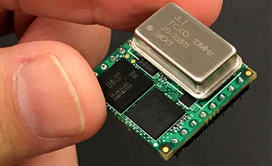
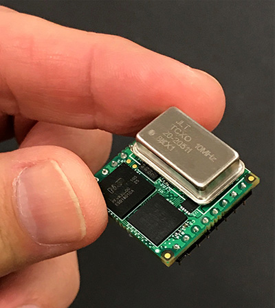
Jackson Labs Technologies Inc. (JLT) released its tiny, new Micro-Transcoder, a full-constellation, stand-alone, real-time 10-channel GPS simulator. The unit can act as a GPS firewall to identify and block jamming and spoofing attempts, and to provide an alternate PNT source during fully GPS-denied operation.
JLT is a designer and manufacturer of GNSS, timing and frequency equipment.
Photo: JLT
The one-inch-square Micro-Transcoder module allows glueless retrofitting of existing GPS equipment by upgrading systems with secure and assured positioning, navigation and timing (PNT) capability, the company said. It achieves hardening of the customers’ GPS equipment by splicing the unit in between the existing antenna and the users’ GPS receiver.
It takes the output of any secure PNT source — inertial navigation system (INS), SAASM, M-code, Iridium STL, or concurrent GNSS receiver — and encodes (RF modulates) the baseband PNT and UTC timing information into a standard GPS L1 RF signal.
This RF signal can then be received by any legacy GPS receiver.
The unit is based on JLT’s CLAW GPS simulator and RSR transcoder technologies, and includes a stand-alone full-constellation 10-channels real-time GPS simulator with integrated high-stability timing reference, as well as an internal GNSS receiver for monitoring the RF output signal for quality and accuracy.
The unit will transmit a standard UTC time, position, velocity and heading GPS L1 RF signal by simply applying 3.3V power to it.
The Micro-Transcoder can also be operated as a generic high-performance GPS simulator with built-in GPS Disciplined Oscillator, and is supported by a comprehensive free Windows application program downloadable from the JLT website.
The Windows application allows control of all the simulation aspects, creating and storing simulation vector commands, and testing user equipment for leap-second and GPS week rollover event compatibility to identify weaknesses in user equipment.
The unit does not require a PC to be connected to it to function. This makes embedded operation as easy as applying power, and connecting the units’ RF output to the antenna input of any GPS receiver.
By generating a legacy RF GPS signal from any secure PNT source, the Micro-Transcoder allows users to maintain their investment in fielded legacy GPS equipment. Example applications include retrofitting financial transaction time servers with CSAC or rubidium atomic clock holdover capability, and adding GPS RF output capability to concurrent GNSS receivers to allow reception of L1, L2, L3, L5 GPS, GLONASS, Galileo, BeiDou, QZSS, Iridium STL, or any other satellite-based navigation signal to legacy GPS receivers.
It can also be used to add inertial navigation system (INS) capability to vehicles and aircraft.
None of these applications require any modifications to be made to the legacy GPS receiver system; all configurations are done externally using the Micro-Transcoder Windows application or a standard terminal program, and on the assured PNT source.
A real-world customer application is a data-center where communications equipment required a GPS signal to operate. The user wanted to prevent vulnerabilities that an external antenna would have introduced. In this scenario, the Micro-Transcoder provided a fixed-position GPS RF signal to a number of the data centers’ GPS receivers, and allowed the GPS user equipment to operate properly without exposing it to the possibility of external jamming or spoofing.
At 0.97 x 0.97 x 0.4 inches and with less than 0.95W power consumption, the Micro-Transcoder is small enough to be designed into emerging assured PNT products, allowing them to communicate gluelessly to existing legacy GPS infrastructure.
The U.S. Army is drafting new rules for the use of GPS receivers in weapon systems to combat spoofing and jamming attacks, as well as signal loss in GPS-denied environments, according to news reports.
The six- to seven-page capabilities requirements document is awaiting a signature from Army leadership, according to Willie Nelson, director of the assured PNT (positioning, navigation and timing) cross-functional team. Nelson spoke to reporters Oct. 9 at the Association of the U.S. Army annual meeting in Washington, D.C.
The Army has been trying for years to complete a GPS requirements document, a “system of systems architecture for assured PNT.” But with virtually every device equipped with GPS, the document would have been too big and too broad, Nelson said.
(Photo: U.S. Army)
The approach now is for separate sets of requirements: one for mounted equipment (now complete and awaiting the signature), a dismounted requirement, and situational awareness.
The difficulty facing the Army is the plethora of PNT systems in use. For instance, an armored personnel carrier may have five to seven unconnected GPS receivers, some with encryption, some without. The weakest receiver could negatively affect the vehicle, Nelson said.
With the new requirements, Army vehicles will have a consolidated, networked, software-based PNT solution. Dismounted receivers used by soldiers will have similar requirements.
Industry will be asked for specific solutions within each of the PNT sectors rather than an “all of the above” solution.
The Army is also expected to create a training program for soldiers that operate PNT systems.
AUVSI Xponential was a big show once again — 8,500 attendees, more than 600 exhibitors, 200 educational sessions and 400 speakers. The show floor was huge as usual, with virtually every kind of UAS product and service imaginable for inspection at small, large and larger booths or display areas.
The morning kick-off presentation on Tuesday was enthusiastic about the coming large-scale adoption of drones and associated robotic technology, with a couple of real-time examples — driverless vehicles at Babcock Ranch in Florida and drone supply deliveries for humanitarian aid in Rwanda.
A view of show floor.
However, there still remain a number of barriers to wide-scale integration of drones into daily life from a regulation perspective, as Steven Bradbury, general counsel of the U.S. Department of Transportation, pointed out — while at the same time also indicating that the Federal Aviation Administration (FAA) has granted hundreds of waivers where the safety case has been adequate for lots of commercial UAS operations.
Most of the major GNSS players were exhibiting at the show, so we focused on gathering their news while also collecting a flavor of the many drone system suppliers in attendance.
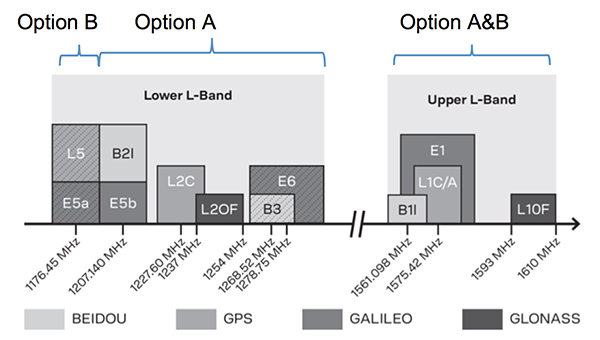
U-blox introduced its new ZED-F9P multi-band, multi-constellation chip — with GPS, GLONASS, Galileo and BeiDou signal reception and processing and on-chip multi-band RTK with fast convergence times — promising centimeter-level accuracy and low 85 mA (4x GNSS) power consumption in a 17 mm x 22 mm package.
ZED-F9P signals: coverage added in two stages. Option A – available now. Option B – available Q2/2020.
Initial urban testing in Finland in challenging conditions has indicated RTK performance at 9 cm 94%, with high availability, short convergence times (<10 seconds) and fast reconvergence. This kind of performance is apparently initially targeted at automotive applications — u-blox is a member of the Sapcorda automotive group — and is forecasting samples for this July, with production beginning before the end of this year.
The NovAtel tagline for the show was “Assured PNT,” which matches many U.S. and International agency objectives — this was accompanied by several announcements for both commercial and government agency products and applications.
The integrated E1 package includes NovAtel’s SPAN technology, which optimizes positioning and attitude performance during extended GNSS outages. Both new PwrPak enclosures come with the Interference Toolkit advanced interference detection and mitigation capability.
With most UAVs, the electronics on the airframe can produce a disruptive internal interference environment, and can lead to potential problems for the integration of sensitive GNSS. To help overcome this issue, NovAtel has released the OEM7600 receiver board in an extremely small form factor, enclosed with protective shielding to reduce the effects of emissions from nearby electronics.
The 7600 comes with 555 channels, multi-frequency/constellation positioning; L-band support for TerraStar corrections; serial, USB, CAN and Ethernet interfaces; advanced interference detection and mitigation features; RTK; GLIDE and Steadyline firmware options with 20-g vibration rating and the option to add integrated SPAN GNSS + inertial.
NovAtel also announced Inertial Explorer Express, which provides the same core processing and utilities as Waypoint Inertial Explorer software for applications including unmanned aerial vehicles (UAVs) and smaller projects. Inertial Explorer Express will produce centimeter-level position and attitude solutions for lidar, camera and other sensor data with faster processing times and reduced complexity.
On the government/agency business side of the house, NovAtel has been quite successful with the GAJT antenna, which includes integrated anti-jam technology. GAJT is in use operationally and has been shipped to 16 allied nations around the globe, with the latest success being with the artillery Observation Post Vehicles (OPV) for the Canadian Army.
The NovAtel GAJT-710ML GPS anti-jam antenna.
The Type 26 Frigate of the British Fleet will use NovAtel anti-jam technology. (Photo: BAE Systems)
Canadian OPVs are used on the front-line of combat, so its essential that their location and timing information should not be compromised by enemy jammers. The NovAtel GAJT is readily retrofitted to existing vehicles to provide the necessary jamming defense needed by front-line forces.
Previously, NovAtel also announced the selection of GAJT for the UK fleet of Type 26 Frigates – providing essential anti-jam protection for its onboard navigation system.
MB-Two module by Trimble.
Chris Wheeler and Omar Subra were good hosts when we visited them at the Trimble booth — Chris first made a YouTube video for GPS World (see below) and then gave me some insights into what’s new.
Basically, the OEM line has rolled over new versions of almost all individual receiver boards, with the addition of the BeiDou B3 frequency, capability for RTX PPP (precise point positioning) corrections, the addition of new constellations and inertial integration options.
An updated MB-Two receiver module can be configured for single frequency GPS through to dual frequency GPS, GLONASS, QZSS, Galileo and Beidou, uses RTX PPP and has an improved RTK engine for cm positioning from a base-station, or from over-the-air RTK corrections, or provides relative RTK against a moving base.
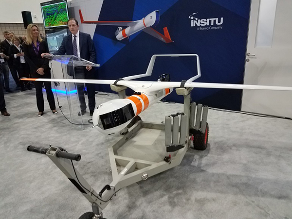
A typical Trimble application could include capturing an Insitu ScanEagle UAV in a difficult shipboard multipath environment with integrated GNSS-inertial, UAV navigation and control, UAV payload stabilization, or providing a “truth-system” for autonomous unmanned ground vehicles.
Since last year when Trimble introduced a “cell-phone” software receiver application, one useful application could have involved an insurance company using a “pocket-carried” antenna (with integrated RF) for field incident assessments. The cell-phone software license would be transferable to other assessors in the department, while a few pocket antennas are available for the whole assessment crew. This saves purchasing a whole load of hardware, and being limited to where the functionality can be moved or deployed. Everyone has a cell phone, and the relatively inexpensive antenna/RF can be available to all needing them.
Watch this video to learn about Trimble’s latest products, including its BD990 and BD992 GNSS receiver boards.
Trimble is also ramping up its OEM customer service and repair capabilities to improve turn around for multiple customers and applications in the field. Improved results are beginning to help customers and its OEM business, while increased R&D investment is expected to put new products into the field in the fall.
This year Intel’s emphasis continued to be on how to manage the huge amount of data that high-precision visual and multi-spectral cameras are gathering by UAVs carrying out asset inspections for their customers. The Intel view is that this data is useless to an end-user unless it is interpreted and presented in a format that can be readily understood and used for the purpose it was intended.
Let’s say a company operates 75 drones inspecting installations it owns or operates across several states, and that 50 GB of data is the nominal amount of data each drone collects on each mission. That means that nearly 4 TB of data could be collected daily if all 75 drones operate at once. More likely, over 1 TB daily shows up in a central location — a huge amount of unprocessed data.
In a live demonstration, Intel showed how a typical installation inspection — by a drone taking high-resolution still photos at a remote location – could be collected and managed. Once in an Intel processing environment, the data quickly became visual format in 2D or 3D, and could be accessed remotely by an inspection team, saving significant travel costs and time to actionable results.
Intel also promised to soon exceed its record at the Pyeongchang Winter Olympics for the number of drones flown at once — currently set at 1,218 drones. The company’s next target is for a light display using 1,500 multi-colored drones.
Insitu CEO Esina Alic
Insitu held a media event at the show to announce its ScanEagle-3 drone system. Esina Alic, the new Insitu CEO, led a team who introduced and then unveiled the new commercial-standard ScanEagle variant.
This new variant has grown out of 20 years of experience and 15 years of working with the FAA to enable integration of drones into the U.S. National Airspace System (NAS). The ScanEagle-3 (SE-3) has been rebuilt with the objective of developing a certifiable vehicle with increased payload and endurance capability that is free of any ITAR restrictions — allowing export without restrictions to the rest of the world.
Insitu unveils the ScanEagle-3 is at Xponential 2018.
SE-3 features include:
Significantly increased (x2) payload
Still provides for full integration of all existing payloads
Commercial, non-ITAR product for the global market
Long-endurance platform
Service contracts available
Product release in Q2 2019
Fully compatible with existing launch and recovery systems
Around ~100 lb without payloads
ScanEagle variants were used in emergency response to the California wildfires at Santa Rosa and Medicina, gathering real-time information for fire-line combatants.
ScanEagle helped fight these wildfires using High Accuracy Photogrammetry (HAP) sensors. Military-grade electro-optical (EO) cameras during daylight and infrared (IR) cameras for night-time imaging extended the time available for tracking fire lines. Penetrating smoke or darkness, these UAVs gathered video and still images that were used to create geo-referenced, high-resolution digital fire progression and suppression maps to guide firefighting on the ground.
This small overview of Xponential 2018 attempts to provide a flavor of the breadth of activity we saw at the show last week. A good portion of this has also been captured through short videos published on the GPS World website, along with news articles.
There is more to come, with a report to follow from the show on Septentrio’s new product releases, Spirent’s GNSS simulation demo, DJI’s overview of drone products featured at the show, CyPhy Works tethered drones, Swift’s announcement of its Skylark correction service trials, Hemisphere’s new Vector Smart Heading Antenna, and Harxon’santennas for drones.
A big show to cover, that’s for sure! It’s a good sign that people were perhaps talking more business than in previous years and a sign that the UAS industry is perhaps moving into its next growth phase.