Tag: autonomous driving

  • Victim suddenly stepped in front of autonomous Uber, data shows

    Police say a video from the Uber self-driving car that struck and killed a woman on March 18 shows her moving in front of it suddenly, according to Bloomberg Technology.

    Uber Technologies Inc. halted its autonomous vehicle tests after one of its cars struck and killed a woman in Tempe, Arizona, in the first pedestrian fatality involving the technology.

    Officials in Boston asked that similar tests by self-driving startup NuTonomy Inc. pauses its tests following the Arizona crash. Toyota also halted its tests.

    A backup driver was behind the wheel but not operating the vehicle. “The driver said it was like a flash, the person walked out in front of them,” Sylvia Moir, the police chief in Tempe, Arizona, told the San Francisco Chronicle. “His first alert to the collision was the sound of the collision.”

    The Uber had a forward-facing video recorder, which showed the woman was walking a bike at about 10 p.m. and moved into traffic from a dark center median.

    “It’s very clear it would have been difficult to avoid this collision in any kind of mode,” Moir said.

  • NovAtel test drives STMicroelectronics’ Teseo APP and Teseo V chipset

    NovAtel test drives STMicroelectronics’ Teseo APP and Teseo V chipset

    NovAtel has integrated its high-precision positioning engine and correction services with automotive-grade multi-frequency GNSS chipsets from STMicroelectronics: specifically, the Teseo APP (Automotive Precise Positioning) and Teseo V.

    The integration demonstrates possibilities for vehicle localization solutions. NovAtel is part of Hexagon’s Positioning Intelligence Division.

    STMicroelectronics’s Teseo APP and Teseo V provide multi-frequency GNSS data for PPP (precise point positioning) and RTK (real-time kinematic) for accurate positioning capabilities.

    The Teseo APP features built-in integrity checking for use in safety-critical systems, whereas Teseo V is used for non-safety-critical precise positioning applications.

    The Teseo V SBAS and Teseo V NovAtel PPP tests took place in a light urban environment. (Image: NovAtel)

    NovAtel’s positioning engine combines the GNSS measurements from these chipsets with inertial measurement unit (IMU) data and Hexagon PPP correction services on the demonstration platform to deliver centimeter-level PPP positioning solutions in real time.

    “Working closely with STMicroelectronics using their Teseo APP chipset allowed us to innovate and speed up the development of our assured positioning solution tailored specifically for safe positioning of autonomous vehicles,” said Jonathan Auld, VP Engineering and Safety Critical Systems from NovAtel.

    NovAtel’s positioning engine architecture enables a flexible integration with different GNSS receiver chipsets, IMUs and processor environments, providing automotive manufacturers with additional flexibility when it comes to selecting components and subsystems of advanced driver assistance systems (ADAS) and autonomous driving solutions.

    The positioning engine is being developed to ASIL-B standards according to ISO26262 and will include a proprietary GNSS integrity solution to ensure safe positioning within defined protection limits that are tailored to the customer’s application requirements.

    “NovAtel’s choice of the automotive-quality ASIL-capable Teseo APP to integrate with their GNSS positioning engine is enabling them to develop a world-class safety-critical positioning offering to the automotive industry,” said Antonio Radaelli, Director, Infotainment Business Unit, STMicroelectronics.

    NovAtel technology continues to be an integral part of the connected and autonomous car ecosystems, including academic research, industry development and real-life applications. The company’s automotive positioning solution includes automotive GNSS antenna technology, GNSS/INS positioning engine, and global correction services.

  • Trimble’s GNSS positioning guides GM’s hands-free Super Cruise

    General Motors (GM) is using Trimble RTX (real-time eXtended) technology as the high-accuracy GNSS/GPS correction source to deliver absolute positioning to vehicles equipped with GM’s Super Cruise hands-free highway driving system, now available on the 2018 Cadillac CT6.

    GM customers using Super Cruise featuring Trimble RTX technology can have peace of mind on the road knowing that RTX plays an important role in maintaining lane position for hands-free driving on divided highways.

    https://youtu.be/_rxW68ADldI

    Super Cruise also uses precision lidar mapping data, a state-of-the-art driver attention system, and a network of camera and radar sensors.

    Trimble RTX technology provides real-time, multi-constellation GNSS positioning capable of achieving better than 1.5 inches accuracy. Standard GPS signals can drift up to 25 feet, which could cause incorrect lane identification.

    The 2018 Cadillac CT6 features Super Cruise hands-free driving technology for the highway. (Photo: GM)

    Lane-level accuracy is a critical enabler in advanced driver assistance systems increasingly being used on highways. When used in conjunction with high-definition maps, cameras, radar and inertial sensors, Trimble RTX improves lane-level positioning performance for semi-autonomous and autonomous vehicles.

    Trimble has a long history of pioneering automation and vehicle autonomy to improve productivity — from providing positioning solutions for some of the earliest robotic applications in the 1990s to delivering automated steering for farm tractors, automated blade control for earthmoving equipment and providing advanced positioning technology for fully autonomous trucks.

    Trimble is now enabling semi-autonomous operations for passenger vehicles with Trimble RTX technology, delivering high-accuracy GNSS corrections via a global network to support absolute vehicle positioning in combination with other sensors and inertial dead-reckoning.

    Trimble’s RTX technology uses signals captured by more than 100 Trimble GNSS reference stations around the globe. Trimble RTX corrects the signals for atmospheric conditions, satellite orbit and time synchronization errors and then sends those signals to GM vehicles with Super Cruise via OnStar 4G LTE cellular.

    The Trimble network is supported by redundant servers that are monitored 24/7 by a team of network engineers and IT specialists ensuring optimal signal performance and reliability for drivers who will depend on it.

    “Through our collaboration, the combined technologies of GM and Trimble will transform the way the world drives,” said Patricia Boothe, vice president of Trimble’s Advanced Positioning Division. “Trimble RTX is now influencing how we interact with our vehicles and the environment around them — helping to minimize driver fatigue and improve the assisted driving experience.”

  • STMicroelectronics multi-band GNSS receiver provides autonomous safety compliance

    Assisting safer autonomous driving, STMicroelectronics has introduced a multi-frequency GNSS receiver chipset suitable for safety-critical automotive applications and high-accuracy positioning at the decimeter and centimeter-level for precise point positioning (PPP) and real-time kinematic (RTK) applications.

    Traditional in-car navigation systems help drivers reach their destinations using receivers and commercial satellite services that allow positioning accurate to within a few meters.

    With increasing use of autonomous systems such as lane-departure warning (LDW), adaptive cruise control (ACC), valet parking and auto-pilot, greater accuracy is needed to ensure safety and reliability, in combination with proximity sensors such as cameras, radar, lidar and others, to monitor the driving environment automatically. Fully self-driving vehicles of the future will also demand high-accuracy positioning.

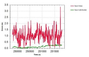
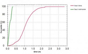
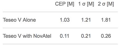
    By tracking satellites of all GNSS constellations simultaneously on at least two of the frequencies used by each system, ST’s automotive-quality Teseo APP (automotive precise positioning) receiver provides high-quality raw GNSS data for PPP and RTK algorithms, which allows accurate positioning and rapid convergence time worldwide.

    In addition to its high accuracy, the receiver monitors the integrity of the satellite data to alert the system if accuracy is degraded for any reason. This permits Tier-1 manufacturers to certify safety-critical systems in accordance with the automotive industry functional-safety standard, ISO 26262, up to the highest Automotive Safety Integrity Level (ASIL).

    Teseo APP also integrates a secure microcontroller for secure system boot and data-output authentication to keep sensitive data safe from attack.

    Launched alongside Teseo APP, ST’s Teseo V chip provides equivalent multi-frequency precise positioning in a simplified device for non-safety-critical applications where integrity assurance is not required.

    “High-accuracy satellite positioning makes autonomous driving safer, smoother, and more reliable,” said Antonio Radaelli, director, Infotainment Business Unit, STMicroelectronics. “Our newest Teseo APP GNSS chip combines extreme accuracy and precision with industry-unique integrity assurance for use in safety-critical applications.”

    Teseo APP eliminates errors by tracking all available GNSS signals in multiple frequency bands, such as the GPS and GLONASS, Galielo, BeiDou, QZSS, and IRNSS L1, L2, and L5 frequency bands, and the Galileo E6 signal that contains PPP correction data to allow worldwide decimeter-level accuracy.

    Other techniques for enhancing accuracy have included differential systems reliant on a combination of ground base-station signals as well as satellite signals, or techniques such as RTK, which generally require a denser reference station network.

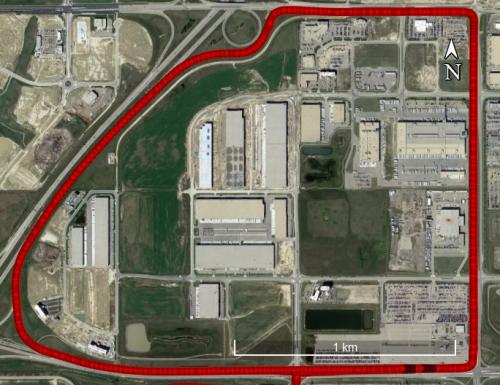
    The new Teseo chips make high-accuracy affordable for autonomous driving through a combination of tracking up to three constellations simultaneously over two frequency domains. These multi-frequency combinations bring reliable GNSS ionospheric and multipath modeling in most environments, allowing accurate positioning with faster convergence time for automotive applications, where timing is critical.

    ST is now supplying product samples to lead customers who are developing autonomous-driving systems expected to appear first in high-end vehicles launched in 2020/2021.

    Visitors to Mobile World Congress 2018 in Barcelona, Feb. 26 to March 1, can see Teseo APP at the ST booth, Hall 7, Stand 7A61.

  • TomTom Autostream provides map delivery for autonomous driving

    TomTom has launched TomTom AutoStream, an innovative map delivery service for autonomous driving and advanced driver assistance systems. The first partners to use the technology — Baidu and Zenuity — were unveiled at the 2018 Consumer Electronics Show.

    TomTom AutoStream enables vehicles to build a horizon for the road ahead by streaming the latest map data from the TomTom cloud. By ensuring that the map used to power advanced driving functions is always the latest, TomTom AutoStream enhances driver comfort and safety.

    “The launch of TomTom AutoStream is a game-changer for OEMs and technology companies that are working on the future of driving,” said Willem Strijbosch, TomTom’s head of autonomous driving. “TomTom AutoStream allows vehicles to access the latest, most up-to-date TomTom map data for their driving automation functions.”

    TomTom AutoStream is designed in a flexible way, allowing customers to customize the map data stream based on criteria such as sensor configuration and horizon length. It can stream a wide variety of map data including ADAS attributes such as gradient and curvature, and the TomTom HD Map with RoadDNA. This flexibility allows customers to use AutoStream to power a wide range of driving automation functions.

    Strijbosch continued, “Our early investment in the TomTom advanced map-making platform means that we can continue to deliver revolutionary innovations like TomTom AutoStream. With TomTom AutoStream we can significantly simplify and shorten the development time for our customers, accelerating the future of driving.”

    TomTom AutoStream ensures that the TomTom map data used to power advanced driving functions is the latest, most accurate available, enabling a safer and more comfortable experience.

    “With AutoStream TomTom is offering an innovative map delivery system targeted at automated driving,” said Roger C. Lanctot, director, Automotive Connected Mobility for Strategy Analytics. “The development is targeted at helping automakers bring ADAS and autonomous driving functions to market faster.”

    TomTom AutoStream will be available for production usage in 2018.