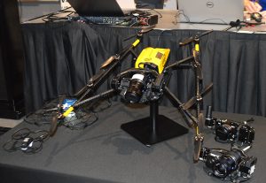
Topcon Positioning Group’s Dave Henderson explains how Topcon’s products are integrated in Intel’s Sirius Pro fixed-wing UAV and Falcon 8+ drone at Xponential 2018 in Denver. Henderson also gives an overview of the new Topcon payloads that will be available for the Falcon 8+.
Tag: AUVSI Xponential
-
SBG Systems showcases inertial sensors, MEMS INS, more at Xponential 2018
SBG Systems’ Christophe Nicolopoulos offers GPS World a rundown on its latest products, including the Apogee Series, the Ekinox 2 Series, the Ellipse 2 Series and Ellipse Micro Series, at Xponential 2018 in Denver.
-
Northrop Grumman discusses polar bear conservation project collaborated with San Diego Zoo Global
Northrop Grumman’s Charlie Welch gives GPS World a rundown on its polar bear conservation project, which was collaborated with San Diego Zoo Global.
-
Trimble presents GNSS receiver boards at Xponential 2018
Trimble’s Chris Wheeler offers an overview of Trimble’s GNSS technology, including its latest receiver boards, which include the BD990 and BD992, at Xponential 2018 in Denver.
-
Septentrio presents AsteRx SB GNSS receiver at Xponential 2018
Septentrio’s Gustavo Lopez offers a rundown on the company’s AsteRx SB ruggedized multi-frequency GNSS receiver at Xponential 2018 in Denver. According to the company, the AsteRx SB can operate in RTK rover or base station mode and, with an on-board 16GB memory, it can log data for offline post-processed PPK.
-
Spirent Federal presents GSS9000 GNSS simulator at Xponential 2018
Spirent Federal Systems’ Kalani Needham discusses the company’s GSS9000 GNSS/GPS simulator at Xponential 2018. Needham also discusses the company’s partnership with Rockwell Collins to develop software that will support M-Code using the Modernized Navstar Security Algorithm.
-
Laser Technology showcases laser range finder at Xponential 2018
Laser Technology Inc.’s Clint Cowan offers GPS World a rundown on the company’s laser range finder at Xponential 2018, which took place April 30-May 3 in Denver.
-
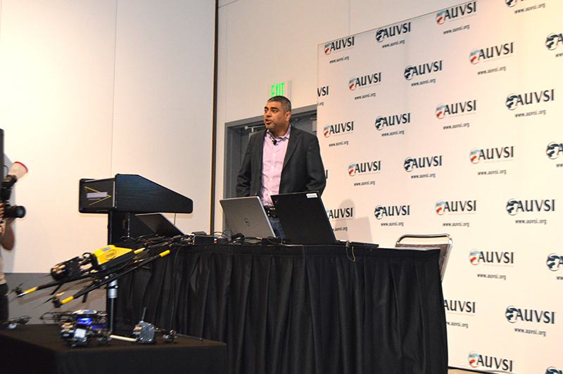
Intel shares updates on Insight Platform, drone solutions at Xponential 2018

Intel’s Anil Naduri discussed some of the company’s updates at Xponential 2018. Photos by Allison Barwacz Intel shared a number of updates at a presentation during AUVSI’s Xponential 2018, which took place April 30-May 3 in Denver. Among the company’s latest developments are its Insight Platform, Mission Control and Falcon 8+.
Intel Insight Platform
Intel’s Insight Platform is a digital asset management system that enables aerial data management and analysis. It allows customers to store, share and manage data that commercial drone systems collect. According to the company, the platform is designed to reduce costs, improve efficiency and fuel growth.
The Intel Insight platform takes the aerial data and can generate 2D and 3D models, take measurements and run data analytics.
“The asset-based approach allows you to tag repeated flights over the same location, and that provides a great foundation for you,” said Anil Nanduri, vice president and general manager of the Intel drone team.
Intel Mission Control
Intel’s Mission Control is the company’s next-generation flight planning software for its Falcon 8+ drone. According to the company, it is designed to increase workflow efficiency and enhance automation of drone flights for commercial missions.
Mission Control allows Falcon 8+ drone operators to create 2D and 3D flight plans for commercial surveying, mapping and inspection missions.
Intel Mission Control software is currently in beta testing with customers, Intel said.
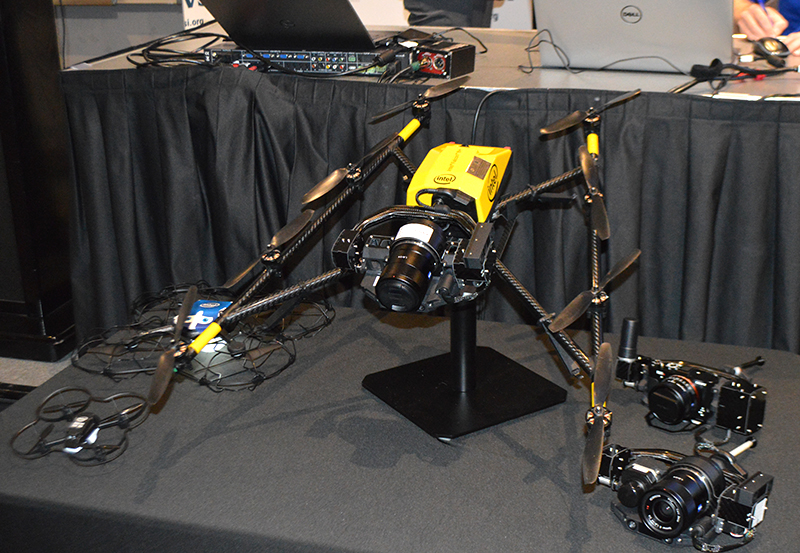
Falcon 8+ drone
Intel revealed three new payloads for its Falcon 8+ at Xponential. Photo by Ryan Gerard During the presentation, Intel revealed three new payloads, as well as distance hold and distance guard features, for its Falcon 8+ drone.
The three new payloads are designed for inspection, surveying and mapping applications. According to Intel, the Falcon 8+ also now boasts distance hold and distance guard features on the Intel Imaging and Duel Imaging payloads. The distance hold feature allows the drone to maintain and hold a set distance from certain obstacles during inspections, and distance guard is another obstacle avoidance feature.
The company also shared how the drone has assisted with natural disasters and safety inspections. The Falcon 8+ played a role in disaster relief for the Sonoma County fires, as well as data recovery following Hurricane Harvey in Houston.
The drone also assisted with a gas terminal inspection in Scotland, as well as with Arctic wildlife research.
“Drones are going to be the most transformative business technology in the coming generation,” Nanduri said.
-

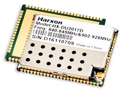
Harxon exhibits positioning, data-transmission tech at AUVSI Xponential
Harxon showcased high-precision positioning GNSS antennas and its latest wireless data-transmission technologies for UAV applications at AUVSI Xponential, which was held April 30-May 4 in Denver.

The Harxon D-Helix Antenna. Harxon’s D-Helix is a patented D-QHA (dual-quadrifilar helix antenna) multi-constellation antenna supports excellent reception of GPS, Galileo, BeiDou and GLONASS, as well as L-band signals. Harxon D-QHA technology ensures the ability of low elevation satellites tracking while maintaining 4-dBi high gain, which makes the D-Helix antenna an excellent choice for any applications where the sky is partially visible, the company said.
The antenna’s low noise amplifier (LNA) with out-of-band rejection performance can suppress electromagnetic interference. Moreover, the D-Helix features the latest low wind resistance design with ruggedized IP67 protection for UAV inspection and monitoring, survey and mapping or agricultural UAVs.
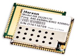
Photo: Harxon The HX-DU2017D is a 5-gram frequency-hopping OEM transceiver supporting frequencies between 840 MHz and 900 MHz. It provides strong anti-jamming and signal receiving capability for complex data intensive applications. Its full duplex mode ensures data secure transmission, more stable long-range communication and short latency of data transmission.
Watch this video to learn more about the HX-DU2017D.
Other showcased Harxon GNSS products, such as Helix Antenna HX-CH7603A, HX-CH4601A and HX-CH6601A, are all featured with patented D-QHA technology. Moreover, the showcased Survey Antenna GPS 500, OEM Modem HX-DU1018D and Smart Antenna are also appropriate for surveying and mapping, as well as precision agriculture.
Photo: Harxon -
Phase One Industrial debuts iXM-100MP metric camera at Xponential 2018
Phase One Industrial’s Steve Cooper offers a rundown on the company’s iXM-100MP metric camera at AUVSI’s Xponential in Denver. According to the company, the iXM-100MP was engineered for for UAV-imaging missions.
-
New Hemisphere GNSS antenna designed for UAVs
Hemisphere GNSS has released its new multi-GNSS, multi-frequency four-helix HA32 UAV antenna.
Hemisphere GNSS made the announcement at AUVSI Xponential, being held this week in Denver, Colorado.
 The HA32 is a high-performance antenna that supports GPS, GLONASS, Galileo, BeiDou, Hemisphere’s own Atlas L-band correction service. It was designed specifically for UAVs, GIS, surveying, real-time kinematic (RTK) and other applications requiring high-precision positioning and navigation.
According to the company, the HA32 is built on an innovative and proprietary four-helix antenna technology that provides superior filtering and anti-jamming performance with low noise amplifier (LNA) features such as a low noise figure of 2.0 dB (typical) and up to 30 dB gain (typical).
Suitable for most outdoor and harsh operating environments, the HA32 antenna is sealed in a durable and ruggedized IP67-rated enclosure for protection against dust and water and is equipped with an O-ring. The lightweight (40 g, typical) and compact form-factor (40 mm x 75 mm) design of the antenna makes it resistant to wind when installed on UAVs and offers easy integration with a single subminiature version A (SMA) RF connector.
“We are very excited to be introducing this extremely competitive entry-level UAV GNSS antenna for a wide range of positioning and navigation applications such as UAVs, GIS, and RTK,” said Miles Ware, director of marketing with Hemisphere GNSS. “The features and specifications of this antenna is another example of the innovation and incredible value that Hemisphere is known for.”
AUVSI Xponential attendees can visit the Hemisphere booth (#4228) to see the HA32 UAV GNSS antenna in person.