Rockwell Collins’ Alex Postnikov discusses the latest technology the company brought to Xponential 2018, which took place April 30-May 3 in Denver.
Tag: AUVSI Xponential
-
Harxon presents HX-DU2017D frequency-hopping modem at Xponential 2018
Harxon Corporation’s Elaine Tao offers a rundown on the company’s HX-DU2017D frequency-hopping modem at Xponential 2018 in Denver. According to the company, this modem has a frequency of 902-928MHz.
-
DroneUp launches program for UAV pilot training, certification
 DroneUp is collaborating with industry leaders and government officials to promote the desired outcomes of the Federal Aviation Administration (FAA), public safety personnel, and the unmanned systems community by announcing the Responsible Community Pilot (RCP) program.
DroneUp is a drone pilot community focused on safer skies through continuous education and sense of purpose. The announcement was made at the AUVSI Xponential show being held this week in Denver.
The mass proliferation of small unmanned aerial systems (sUAS), specifically those operated by non-commercial pilots, has created nearly unparalleled policy, safety and legislative issues.
To remove confusion and help increase resources available to all pilots, DroneUp is partnering with the International Association of Community Drone Pilots (IACDP) to provide tools and resources to meet the real objectives of improving airspace safety.
By providing free access to a community-based set of guidelines and programming, the RCP program engages drone pilots through training, certification, idea-sharing and community.
DroneUp provides the means and connections with the community to help pilots operate in the national airspace. Some of those free tools include:
- Continually updated online courses and exams that improve regulation awareness
- Mission-driven experiential exercises that improve piloting skills
- An online community for questions and discussion
- Mobile apps that verify where it is safe to fly and active advisories nearby
- Comprehensive Standards of Conduct
- Detailed Safety Guidelines
- Advocacy on behalf of the community
“Our efforts to build this community through training and a sense of purpose are having dramatic positive effects on ensuring air safety,” said Tom Walker, Founder and CEO, DroneUp. “We are dedicated to not only continuing our efforts, but to sharing collected data that will prove invaluable to officials as they draft future policies.”
In advocating for both commercial and non-commercial use of small unmanned aircraft systems, IACDP represents commercial, recreational, military and public safety pilots.
“IACDP is motivated by a desire to make a positive impact on the industry,” said IACDP President John Evans. “We are still growing and expanding our training, certification, and advocacy resources. We see organizations like DroneUp as valuable strategic partners for our mission.”
To date, more than 20,000 non-commercial sUAS pilots are active members of DroneUp’s RCP community. Through affiliations with its non-profit partners, this number is expected to increase to more than 100,000 sUAS pilots over the next six months.
Membership in DroneUp’s RCP program requires successful annual completion of the RCP training and examination online.
Upon completion of the certification, RCP participants will receive a certificate with a unique ID number, an RCP badge in DroneUp’s mobile app; they also may request a personalized RCP ID Badge.
-
AUVSI Xponential preview: IMUs key to UAV imaging advances
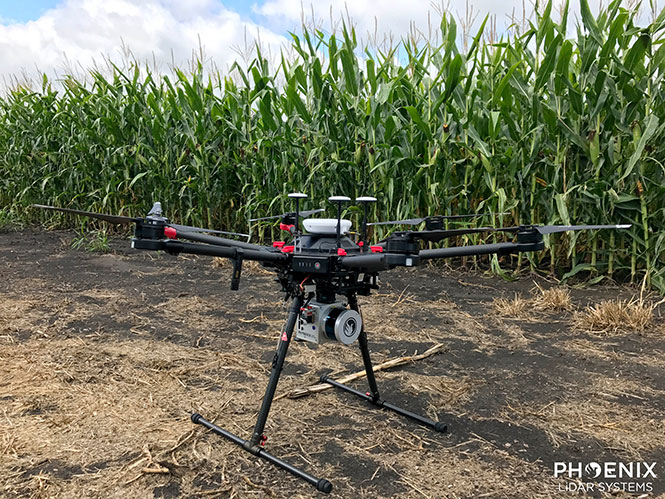
Phoenix Lidar’s Scout System features NovAtel SPAN GNSS/IMU equipment and a pinwheel antenna. Combined with Phoenix’s hardware and software, this lightweight UAV lidar system serves in agriculture, construction and other general mapping applications. Here the Scout is integrated with the DJI M600 Pro UAV. (Photo: Phoenix Lidar Systems) As a UAV flies, it is subject to roll, pitch and yaw movements, adversely affecting the high-definition imagery that industrial-grade UAVs are designed to collect. Three measures combat unwanted movement: a stabilizing gimbal, a high-quality GPS/inertial measurement unit (IMU) integration, and orthorectification of the data during post-processing.
Imaging applications are driving all sectors of the booming UAV market. The increasing availability and variety of compact, robust, lightweight sensors, employing a range of super-resolution and often multi-spectral and hyperspectral technologies, continuously expand and improve UAV applications.
Three companies exhibiting at the Association for Unmanned Vehicle Systems International’s (AUVSI’s) massive Xponential show May 1-3 will showcase recent advances in this arena.
Challenges of Airborne Imaging. Size and weight govern UAV deployment.Imaging sensors must fit compact payload bays. An integrated UAV solution will typically include an imaging sensor, a high-performance GPS/inertial measurement unit (IMU), and a data storage hub to collate streams of data from all connected instruments.
Software geared specifically to flight supplies image orthorectification and manages sensor operation during the mission, enabling users to input GPS coordinates for sensor operation. Outside of defined coordinates, the sensor will not collect data, reducing the amount of data to store or transmit.
Immediate or real-time processing and georeferencing of imaging products has always been key to defense and security applications; it becomes critical for precision agriculture, cartography, civil engineering, remote monitoring and surveillance, intelligent inspection, disaster preparedness and risk study, newsgathering, cinematography, tourism and even commercial advertising. A multisensor landscape view can improve a UAV’s ability to react intelligently without operator input.
Integrated GPS/INS exhibitors at the Xponential show include:
NovAtel (Booth 3219). The company uses a flexible technology platform and diverse OEM products, which include SPAN technology: tightly coupled GNSS receivers with IMUs for reliable, continuously available, position, velocity and attitude, to deliver its vision of assured positioning — anywhere.
NovAtel offers TerraStar Correction Services to provide accurate real-time sub-meter or decimeter positioning around the world, anytime. Its Waypoint Inertial Explorer Xpress post-processing software provides the same core processing and utilities as Inertial Explorer along with simplified functions and workflows tailored for UAV markets and small project areas.
VectorNav (Booth 2214). Engineers at Octopus ISR integrated the VectorNav VN-200 GPS/INS directly into the optical bench of a gimbal to deliver positioning accuracy under flight conditions such as high vibrations, accelerations and temperature fluctuations. The device flies aboard the UAV Factory’s miniature Epsilon series of gyro-stabilized gimbals, enabling the Precision Geo-Lock feature, which combines a GPS-aided inertial navigation system with dedicated software algorithms and payload operator software.
The VN-200 features 16g accelerometers and 2000°/sec gyros in a postage-stamp-sized surface-mount device and a rugged package. Epsilon gyro-stabilized turrets are available with both VectorNav’s VN-200 single GPS-based INS solution and the VN-300 dual GPS-based INS.
SBG Systems (Booth 2535). The company developed specific calibration procedures to provide reliable heading even when UAVs tilt. Magnetometer calibration can be processed in 2D on the ground, or in 3D in flight. Qinertia software enhances inertial navigation systems performance by post processing inertial data with raw GNSS observables.
SBG Systems’ Ellipse 2 Micro high-performance inertial sensors reduces size and costs and for volume projects. It is available as an inertial measurement unit (IMU), or as an attitude and heading reference system (AHRS) or inertial navigation system (INS) running an extended Kalman filter, connected to an external GNSS receiver.
-
What to expect at this year’s AUVSI Xponential drone show

Tony Murfin
Contributing Editor, Professional OEM & UAV, GPS WorldAs the days tick down towards the always-anticipated Association for Unmanned Vehicle Systems International (AUVSI) Xponential convention in Denver May 1-3, the unmanned vehicle industry is preparing once more for one of its largest exhibitions.
More than 750 exhibitors will be spread over a huge 370,000-square-foot exhibit floor at the Colorado Convention Center and 8,500 visitors from unmanned systems and robotics are expected to come to share ideas, gain insights and carefully examine the unmanned innovations on show.
STEM Outreach. This year the show will not only feature industry innovation and growth, but will also highlight resources for potential science, technology, engineering and math (STEM) graduates with interactive and engaging content, including:
- A buildathon/hackathon to conceive, design and build inventions during a timed competition prior to Xponential. Final projects will be displayed on the Xponential show floor as a representation of innovation and collaboration.
- A dedicated area in the Xponential exhibit hall will describe the STEM education programs and services supported by AUVSI and the AUVSI Foundation to foster and cultivate the next generation of innovators and leaders.
- An area of the show floor will also showcase the winners of student robotics competitions.
- Denver area high school students will be invited to tour the exhibit area to introduce them to emerging unmanned technologies and applications.
- A reception at the show promises to mix young professionals in unmanned systems with seasoned industry leaders, and finally,
- The Women and Diversity in Robotics forum will feature speed networking with leaders to review STEM opportunities for career-focused women and girls.
Survive and Thrive. Meanwhile, the Denver exhibition will demonstrate how the rapidly evolving world of UAVs has encouraged “survive and thrive” for those new entrants who together seem to have adapted to address almost any and all opportunities. We’ll mention a couple of examples here, and attempt to provide a better cross section of the huge number of companies and products present following the actual show.
For instance, one of the drawbacks for small, predominantly electric-powered, multi-rotor UAVs is that their endurance is limited. Providing longer duration operations may be outside their envelope — for such longer term things as providing temporary mobile-phone signal coverage, or police/agency reconnaissance/search, or for larger vertical inspection jobs.
Presumably, floating one of several available models of lighter-than-air, blimp-type UAVs might be more expensive or cumbersome than using a multi-rotor unmanned vehicle, so overcoming power-supply issues would seem to be key. One way to do this is to attach a strong tether bringing power up from the ground.
Orion UAS. The Elistair (France) Orion UAS will no doubt be featured on the company’s booth. This multi-rotor UAV has been developed for longer term aerial surveillance and telecommunications operations. Typical users include law enforcement, private and public safety, national security, asset protection, emergency communications and crisis management, so these tethered drones are deployed by police forces, public security departments, public and private security companies, and governments in more than 30 countries.

Photo: Elistair The Orion UAS uses industrial components and system redundancy, including autopilot sensors, motors, power distribution and logic controls, and has an emergency parachute system. The patented micro-tether system ensures a stable platform supplied with continuous power from the ground to enable up to 10 hours of endurance. The mechanical structure of the drone is designed to sustain strong winds with maximum stability. With system redundancies and automated emergency procedures, the user is able to focus on safety-critical missions and data collection, while the risk of human mistakes is reduced.
The onboard camera has both FLIR and optical, enabling night/day surveillance with gimbal stabilization and low latency — the 30x optical zoom makes it possible to detect a moving person from kilometers away. And the tether system provides high-speed, interference-free data transmission so the system is also virtually undetectable. It’s easy to see why tethered drones are becoming more popular for security applications.
 Identifying UAVs. At the FAA Unmanned Aircraft Systems (UAS) Symposium last week in Baltimore, a key issue discussed concerned remote identification and tracking of drones. It would seem that the FAA is about to announce a new rule that could eventually clear the way for drones flying over people and beyond line-of-sight of their operators — and this may be a key topic of discussion at Xponential.
The FAA rule appears to mandate that every drone should in some way communicate its identification — presumably its FAA registration ID — so that its operator could also be known.
One well-known company, Ford, has already announced that it has a concept using onboard collision lights on a drone to optically signal the 10-digit FAA registration number to the ground for capture and decoding. Maybe other exhibitors at the show will have other solutions — perhaps radio based? We’ll see.

Sensefly eBee drone. Sensefly’s eBee. At the sensefly booth, we may also hear about several interesting announcements on recent drone applications:
- Products on display will include the RTK/PPK-enabled eBee Plus professional mapping drone, the eBee SQ drone for agricultural applications and the albris mapping and inspection drone, as well as the senseFly S.O.D.A camera and GeoBase.
- In addition, senseFly sales manager and GIS scientist Briton Voorhees will deliver a presentation titled, “Comparing workflow and point cloud outputs of the Trimble SX10 TLS and senseFly eBee Plus drone,” on Wednesday, May 2, at 11 a.m. in the Mapping and Surveying Track.
- Booth visitors can also find out more about senseFly’s comprehensive 360 solutions, which are designed to improve operational efficiencies and support decision-making in the surveying, mining and quarries, agriculture and inspection sectors.

And many more. GNSS players also expected to be at the show include Hemisphere GNSS, NovAtel, Rockwell-Collins, Septentrio, Tersus, Trimble, Accord/Aspen Avionics, Comnav, Navtech, Swift and Topcon, as well as GNSS chip manufacturers u-blox and Intel — although Intel may likely focus on its UAV/communications offerings at this show.
There will also be a number of antenna suppliers, inertial sensor manufacturers, UAV autopilot manufacturers and several ancillary electronics and mechanical systems suppliers — all trying to solidify their positions in the UAV vehicle and systems integration supply chain.
The major focus, as usual, will be on UAV/UAS vehicle manufacturers and system integrators and their products — there is always a great exhibition of actual UAVs from all sectors of the industry.
So, along with a parallel program of educational presentations on a wide range of industry aspects, the AUVSI Xponential convention promises to have plenty of opportunities to find things of interest to almost anyone, and many areas to focus on for experts already in the industry.
Tony Murfin
GNSS Aerospace -

Swift, Carnegie release Duro for ground robots
Swift Navigation and Carnegie Robotics released their first joint product at AUVSI’s Xponential: the Duro, a ruggedized version of Swift Navigation’s Piksi Multi dual-frequency RTK GNSS receiver.
 Built for outdoor operations, Duro combines a rugged enclosure with centimeter-accurate positioning. Leveraging design principles typically used in military hardware, the GNSS sensor is protected against weather, moisture, vibration, dust, water immersion and unexpected circumstances that can occur in outdoor long-term deployments. In addition to its ruggedness, Duro is ready to connect right out of the box. Primary industries for this product include: robotics, precision agriculture, mapping, military, outdoor industrial and maritime.
Photo: Swift NavigationDuro incorporates:
- Dual-frequency RTK GNSS
- Tough, military-grade hardware
- IP67 rating
- Weatherproof external enclosure design with M12 standard-sealed connectors
- On-board MEMS IMU and magnetometer
- Future-proof hardware with in-field software upgrades
- Protected IO, including RS232 Serial Ports, 100mbit Ethernet, Event Inputs, PPS, PV, CANBus
- Durable UV and chemical-resistant powder-coating
- Flexible mounting interfaces
-
UAV testing facility selects Harris for BVLOS support
Grand Sky Airfield Operations, a 217-acre UAS test facility in North Dakota, has selected Harris Corporation to provide an advanced solution to support beyond-visual-line-of-sight (BVLOS) unmanned aerial systems (UAS) flight operations, reducing the need for chase planes to provide constant visual surveillance during flight. Grand Sky tenants will have the ability to conduct BVLOS UAS flights, enabling commercial and government operators to deploy their technologies, test and conduct operations. The announcement was made during AUVSI’s Xponential.
Harris will provide a customized RangeVue sense-and-avoid solution that delivers real-time situational awareness of surrounding unmanned and manned aircraft traffic, with multi-sensor surveillance for cooperative and non-cooperative vehicles. airspace situational awareness tool designed specifically for test-range operations for unmanned air systems (UAS). RangeVue puts real-time NextGen surveillance data, obstacle data, flexible background maps and weather information in the hands of the people who are actually in the field testing and validating UAS missions. The solution will cover the 217-acre unmanned aircraft business and aviation park located on Grand Forks Air Force Base, North Dakota.
It will enhance Grand Sky’s infrastructure for safe and efficient BVLOS UAS operations and testing, ensuring the FAA’s stringent safety requirements are met and eliminating the need for expensive chase planes to track UAS entering, exiting or operating within Grand Sky’s 60 nautical-mile radius airspace.
Harris’ Grand Sky solution will combine available surveillance sources — including Grand Forks AFB’s radar feed, locally installed ADS-B Xtend and FAA NextGen surveillance data — into a single stream that offers area coverage and airspace visualization for drone operators. Xtend supplements the FAA’s existing ADS-B nationwide network operated by Harris, which provides precise and reliable satellite-based surveillance for the nation’s air traffic control system.