CorvusEye 1500 is one of the programs Exelis is featuring at Association for Unmanned Vehicle Systems International’s (AUVSI’s) Unmanned Systems 2015, held May 4-7 in Atlanta (booth #2449). From an altitude of 15,000 feet, CorvusEye 1500 provides color and infrared imagery of a city-sized area unavailable with comparable airborne systems. Bernard Brower, product manager for Exelis, shows us how users work with the real-time analytics and processed data to search for vehicle tracks based on location and time.
Tag: AUVSI
-
Septentrio Launches UAS Receiver, Software for Drone Market

The AsteRx-m UAS by Septentrio. Septentrio has launched the AsteRx-m UAS, an RTK-accurate GNSS receiver solution specially designed for the drone market. The AsteRx-m UAS provides high-accuracy GNSS positioning with low power consumption, according to Septentrio.
The launch of the AsteRx-m UAS board is complemented by the release of GeoTagZ software suite. The GeoTagZ suite works with the UAS camera and image-processing solution to provide centimeter-accurate position tagging of images without the need for a real-time data link.
The AsteRx-m UAS will be on display at booth #635 during AUVSI’s Unmanned Systems 2015, held May 4-7 at the Georgia World Congress Center in Atlanta.
Despite being Septentrio’s smallest receiver, the AsteRx-m UAS provides consistent, robust and accurate positioning from to Septentrio’s in house GNSS+ algorithm technology. The receiver delivers cm-level accuracy at less than 600 mW with GPS and less than 700 mW with GLONASS. LOCK+ technology guarantees tracking under heavy usage and IONO+ guarantees no interference in challenging ionospheric conditions, Septentrio said.
Integration into Any UAS. One of the key characteristics of AsteRx-m UAS and GeoTagZ is the seamless integration into any UAS. AsteRx-m UAS features standard connection functionality that directly connects to a UAS autopilot, such as Pixhawk and Ardupilot. The power comes directly from a number of power sources, including micro USB, a 9-30V external power supply or the vehicle power bus. GeoTagZ is available as a library of software to integrate into an UAS image-processing tool chain.
“We want to make UAS-based data collection and processing extremely simple. AsteRx-m UAS and GeoTagZ do just that,” said Jan Leyssens, commercial product manager at Septentrio. “The GNSS board connects seamlessly to standard hardware and cameras used on a drone. Together with our software, we provide a data collection solution that provides cm-level accuracy without the need for ground control points or real-time data links, and that integrates effortlessly with an existing UAS image processing software solutions.”
-
UASUSA to Debut Payload Upgrades at Unmanned Systems

Skip Miller, UASUSA’s founder and CEO, stands with with the Tempest ET. UASUSA will unveil its payload advancements in booth 631 at AUVSI’s Unmanned Systems 2015, held May 5-7 in Atlanta.
The new Trimble RTK high-accuracy GPS positioning system will be available through UASUSA. It covers up to 2,300 acres per flight for photo mosaic and mapping missions with manufacturer specified sub-centimeter accuracy.
UASUSA also modified its leading aircraft, the Tempest, to create the Tempest ET. The new aircraft has added payload storage interchangeable in the wing tip extensions, yet still offers the same level of stability, endurance, efficiency and aesthetics as the Tempest, UASUSA said.
The Tempest ET is designed for magnetometer use in the mining industry and offers interchangeable regular, extended and payload tips. With its 10- to 15-pound payload capacity, it may carry the Phoenix Aerial LiDAR system to cover large areas and create survey-grade point clouds.
-
AUVSI Unmanned Systems Offers Demonstrations, Exhibits
The Association for Unmanned Vehicle Systems International (AUVSI) will host Unmanned Systems 2015, which will run from May 4-7 at the Georgia World Congress Center Atlanta. With 8,000 attendees from around the world, Unmanned Systems 2015 is the largest expo and trade show in the industry, according to AUVSI.
The event will include three days of interactive exhibits and exciting demonstrations of air and ground vehicles spread throughout 350,000 square feet of exhibit space. The 150-plus educational sessions, workshops, and panel presentations will focus on the future of commercial, humanitarian, environmental, governmental, and military applications for robotics and unmanned systems. For more information on the sessions, see AUVSI’s Program Planner.
This year’s conference will feature keynote addresses and panel discussions by:
- Colin Guinn, chief robotics officer, 3D Robotics
- Dave Vos, project lead, Project Wing @ GoogleX
- David Vigilante, senior vice president, legal, CNN
- Helen Greiner, CEO, CyPhy Works
- Hugh Herr, MIT professor and head of biomechatroinics at the MIT Media Lab
- Rep. Frank Lobiondo, New Jersey House of Representatives
- Henrik I. Christensen, distinguished professor, KUKA chair of Robotics, and director of the Robotics & Intelligent Machines Center, Georgia Tech
For more information and a full agenda of events, visit www.auvsishow.org.
-

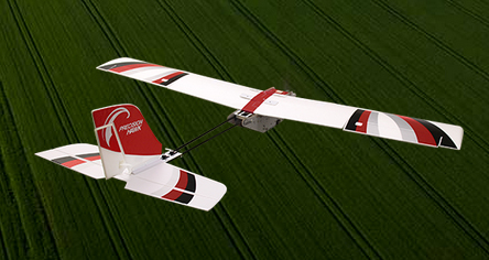
FAA Grants 30 More Commercial UAS Exemptions
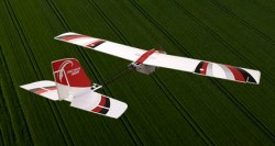
The PrecisionHawk UAV. The Federal Aviation Administration has approved 30 more commercial unmanned aircraft systems exemptions, bringing the total number of approved operations to 99, reports AUVSI News. AUVSI is the Association for Unmanned Vehicle Systems International.
Among those receiving exemptions are the insurance companies USAA and AIG. USAA said in a press release that the exemption “could help speed review of insurance claims from its members following natural disasters.” USAA plans to fly the PrecisionHawk drone.
USAA also filed for an additional FAA exemption in November that will enhance USAA’s ability to use drones in catastrophes. That exemption petition is pending approval, and a decision is expected soon.
Other companies receiving exemptions include senseFly for precision agriculture, and AeroVironment for agriculture, aerial survey and patrol applications.
-
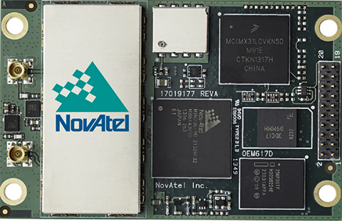
NovAtel Launches OEM617D Single-Card GNSS Receiver with RTK
NovAtel’s OEM617D receiver. NovAtel Inc. has released the OEM617D receiver, a compact, dual-antenna, dual-frequency, single-card receiver with NovAtel’s ALIGN heading functionality and RT-2 Real Time Kinematic (RTK) GNSS positioning technology, in dynamic and static environments.
NovAtel made the announcement at AUVSI’s Unmanned Systems 2014, being held this week in Orlando, Florida.
The OEM617D offers complete dual-frequency operation with GPS, GLONASS, and BeiDou signals maximizing GNSS availability globally. It also tracks Galileo, SBAS, and QZSS. It is designed for rotary-wing aircraft, marine, autonomous ground vehicle, and other applications requiring precise position and heading accuracy.
NovAtel’s advanced firmware and correction capabilities enhance the positioning performance of the OEM617D receiver, the company said. Firmware is field upgradable and scalable, depending on application needs. In addition to RTK centimeter-level real-time positioning, and ALIGN precise heading and relative positioning, the OEM617D offers GLIDE for decimeter-level pass-to-pass accuracy and RAIM for increased GNSS pseudorange integrity.
“We continually listen to our customers to ensure we develop new innovations that address their performance requirements and ensure their competitive success in the marketplace,” said Cameron Henderson, NovAtel’s product manager, Core Cards. “With the release of OEM617D, we’ve delivered robust and accurate positioning on our smallest form factor, making it a great solution for the unmanned market.”
-
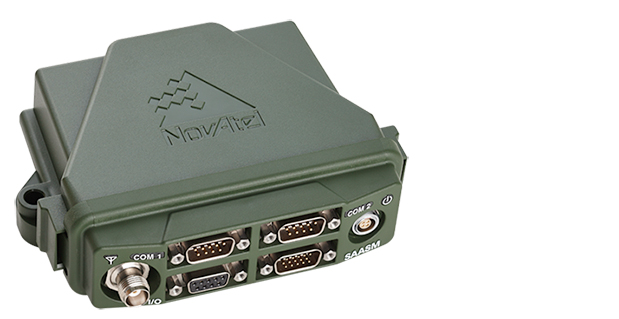
FlexPak-S GNSS Enclosure Delivers SAASM Positioning for Defense
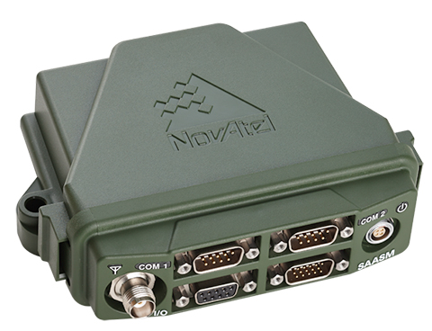
NovAtel’s FlexPak-S GNSS SAASM enclosure. NovAtel has launched the FlexPak-S GNSS SAASM enclosure. The FlexPak-S contains a NovAtel dual-frequency OEM625S receiver card integrated with L-3’s XFACTOR Selective Availability Anti Spoofing Module (SAASM) onboard. The FlexPak-S is security-approved by the GPS Directorate for operational use.
NovAtel made the announcement at AUVSI’s Unmanned Systems 2014, being held this week in Orlando, Florida.
When keyed by authorized defense integrators, the FlexPak-S provides centimeter-level Real Time Kinematic (RTK) Precise Positioning Service (PPS) solution by taking the raw measurements from the XFACTOR SAASM and applying them to NovAtel’s Advanced RTK algorithms. The FlexPak-S can be handled as unclassified when keyed.
In the Standard Positioning Service (SPS) fallback mode, the FlexPak-S continues to provide centimeter-level accuracy by utilizing NovAtel’s dual-frequency civil GNSS positioning engine. FlexPak-S’ fallback mode is configurable for GPS or GPS+GLONASS. Adding GLONASS tracking increases position performance in obstructed sky conditions, which is a benefit for unmanned ground vehicles.
FlexPak-S was developed for size-constrained environments, so it’s compact and lightweight, NovAtel said. Despite its size, the rugged GNSS enclosure has been engineered to ensure reliability, even in harsh environments. The IP67 housing is water-resistant and operates in a wide temperature range. FlexPak-S also allows for easy integration with standardized hardware connections and NovAtel’s comprehensive set of software commands. The SAASM position is provided via a dedicated communication port, as well as through NovAtel’s software command protocol, allowing for maximum flexibility. FlexPak-S uses the same form factor as the FlexPak6 design.
“FlexPak-S is a great option for customers looking for a reliable solution in environments where size is critical, like UAV and robotics applications,” said Shane McEwen, product manager for NovAtel Enclosures. “With standard software and hardware connections, integration is simplified so there is a quicker time to market.”
The FlexPak-S is available to order immediately.
-
Sparton Introduces GPS-Assisted Inertial Navigation System
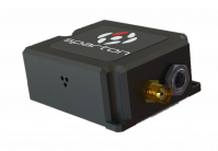
photo: Sparton Sparton Corporation has announced that Sparton Navigation and Exploration will introduce its GPS/ GNSS Assisted Inertial Navigation System, GAINS-10, at AUVSI Unmanned Systems 2014.
GAINS-10 provides accurate inertial navigation in the presence of mechanical shock, transient platform vibrations and extreme magnetic interference. It features high speed, synchronous sampling of all inertial systems combined with high rate coning and sculling compensation and is fully calibrated across temperature.
“The GAINS-10 delivers precise performance in complex environments,” said Jim Lackemacher, Group vice president of Sparton’s Defense & Security Engineered Products. “Sparton’s GAINS-10 provides flexible integration options and platform customization.”
Features of GAINS-10:
- Advanced EKF implementation coupled with Sparton’s proprietary AdaptNav sensor fusion algorithms
- Multi-GNSS receiver module using multiple satellite constellations in parallel
- 10 DOF High Performance Inertial Measurement Unit
- Enhanced MEMS sensing technology (3-axis magnetic, 3-axis acceleration, 3-axis gyro and barometer)
- High-speed synchronous sampling of all inertial sensors
- Customizable on-board high speed digital filtering
- Sculling and coning compensation
- High-speed data logging capability to off-board uSD card
- Ruggedized, shockproof design, with proprietary seals that allow barometric pressure sensing combined with IP67 performance
- Low power consumption with power management functionality (Sleep Mode)
- Interface to external GPS receiver
- External data interface via Multi-GPIO connectivity
- Powerful user programmable customizations via NorthTek(TM) Forth interpreter
Sparton AUVSI 2014 Events Schedule: Sparton Navigation and Exploration will be featured at the “Beyond the Booth” showcase Wednesday, May 14th at 11:30am (EDT).
Throughout the AUVSI show, Sparton will host in-booth presentations along with live demonstrations.
-
Accord Debuts NexNav GPS Tech at AUVSI Convention
Accord Technology, maker of NexNav products, is debuting its capabilities for enabling fully FAA compliant GPS for Detect and Avoid at the AUVSI Unmanned Systems annual convention, being held in Washington D.C. August 12-15.
Known for its certified, U.S. FAA ADS-B fully compliant GPS WAAS/SBAS sensors and receivers for NextGen solutions in the airline, business and general aviation industries, NexNav products include OEM circuit-card assembly receivers the size of a credit card as well as line replaceable sensor units.
This is the company’s first time exhibiting at the AUVSI conference.
“We are excited to be exhibiting at this show and I believe our NexNav products will fill a niche that the unmanned aircraft need,” commented Hal Adams, Chief Operating Officer for Accord Technology, LLC. “Our NexNav product already meets FAA requirements and us currently flying on many manned platforms as well as on EU UAS platforms now. I look forward to talking with attendees about the Detect and Avoid GPS solution NexNav can provide them.”
Accord Technology received TSO-C145c for its NexNav mini in 2010, and fully qualified as GPS source per the U.S. FAA ADS-B Advisory Circular 20-165. The NexNav mini GPS technology was the first GPS WAAS sensor to be authorized U.S. FAA TSO-C145c WAAS Class Beta-1 ONLY. It is a market-breaking hybrid of automotive technology and aviation requirements providing an affordable solution for ADS-B GPS source, Accord said.
-
GPS Innovation Alliance Welcomes New Affiliates
Five major national organizations representing a variety of industries are joining the GPS Innovation Alliance as affiliate members.
The alliance announced today that the American Trucking Association, the Association for Unmanned Vehicle Systems International (AUVSI), Boat U.S., the National Rural Electric Cooperative Association (NRECA) and the National Society of Professional Surveyors (NSPS) have signed on as alliance affiliates. Each shares in the alliance’s goal of protecting, promoting and further enhancing one of the world’s most important enabling technologies — technologies that improve the lives of people around the globe.
Headquartered in Washington, D.C., the GPS Innovation Alliance was launched in February. Its founding members are Garmin, John Deere, Topcon Positioning Systems and Trimble. Affiliate members previously announced include the Association of Equipment Manufacturers (AEM), General Aviation Manufacturers Association (GAMA) and the National Association of Manufacturers (NAM).
Following are comments from representatives of the newly announced affiliates.
Ted Scott, director of Engineering, American Trucking Associations: “GPS is important to the trucking industry. A robust and reliable GPS system enables drivers and fleet managers to select the best routes to guarantee pickup and delivery times, and to track shipments and fleets. It also helps save fuel by providing the most efficient routes. As GPS continues to modernize, we are pleased to support the GPS Innovation Alliance as an affiliate.”
Curtis W. Sumner, executive director, National Society of Professional Surveyors: “The productivity and precision benefits GPS provides professional surveyors are boundless. Virtually all surveyors use it for a growing number of applications that improve the national infrastructure every day. The modernization of GPS is critical to the future of surveying, which is why NSPS is pleased to offer the GPS Innovation Alliance its support moving forward.”
Michael Toscano, president and CEO, Association for Unmanned Vehicle Systems International: “All around the world, unmanned systems (air, ground and maritime) rely on accurate, dependable GPS signals. The lack of a reliable GPS signal poses a serious threat to our public safety and national defense, and this is why we support the GPS Innovation Alliance. We look forward to working with the Alliance in its effort to emphasize the importance of protecting our GPS.”
Margaret Bonds Podlich, president, Boat U.S.: “For anyone who has sailed their boat in unfamiliar cruising grounds, sought out new fishing holes, had to navigate in foul weather or simply stay the course in an unmarked channel, a reliable GPS system is a critical safety issue for everyone aboard. It is the only electronic navigation system available to boaters, and for our half a million BoatU.S. members, it must work every time, all of the time.”
Laura Marshall Schepis, senior director, Legislative Affairs, National Rural Electric Cooperative Association: “NRECA is pleased to be a part of the GPS Innovation Alliance. Electric cooperatives are increasingly relying on GPS technology as they upgrade and modernize the nation’s electric system. The GPS Innovation Alliance can support modernization by ensuring utilities have access to the spectrum they need for these new applications.”
The GPS Innovation Alliance recognizes the ever increasing importance of GPS and other GNSS technologies to the global economy and infrastructure and is firmly committed to furthering GPS innovation, creativity and entrepreneurship. The GPS Innovation Alliance seeks to protect, promote and enhance the use of GPS.