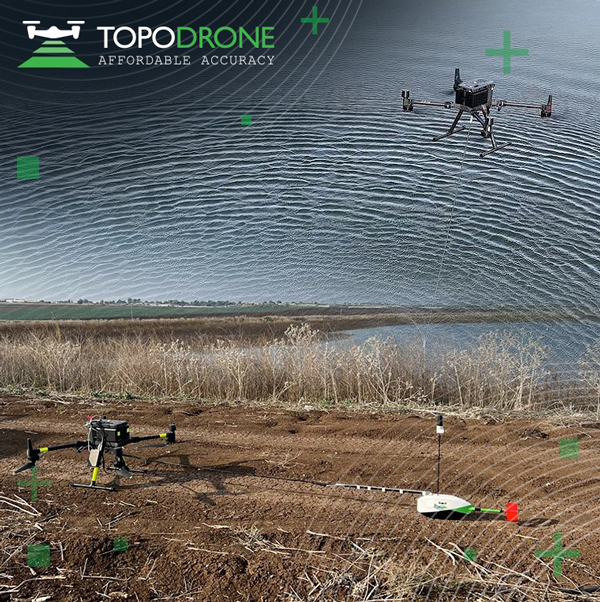
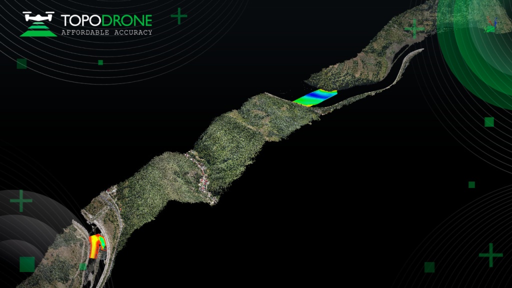
On Jan. 12, TOPODRONE used its synchronized lidar, airborne photogrammetry and bathymetric surveying methods to study a floating solar farm in Israel. This was completed upon request from the UAV service provider ERELIS, to help conduct a pilot project of reservoir surveying with a UAV for ETZ HADEKEL in northern Israel.
As the surface of the reservoir in Northern Israel is covered by solar panels, it is difficult to use standard methods of surveying from a boat. The goal of this study was to create 3D models, which can be used for high-precision assessments of sediment volumes, general monitoring of reservoir banks and visual monitoring.
Image: TOPODRONE
During this project, ERELIS performed two-stage UAV surveying to create the 3D model of the reservoir. In the first stage, aerial photogrammetry and lidar surveys were performed using a DJI M300 UAV. The UAV was equipped with the P61 TOPODRONE camera and a lidar high-resolution system to determine the location of obstacles. The lidar scanning provided accurate detection of cables in the water.
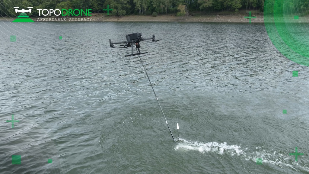
The second stage included an underwater bathymetric survey using the TOPODRONE AQUAMAPPER mounted to the DJI M300 UAV. The flight mission was planned and executed with the UgCS software by SPH Engineering.
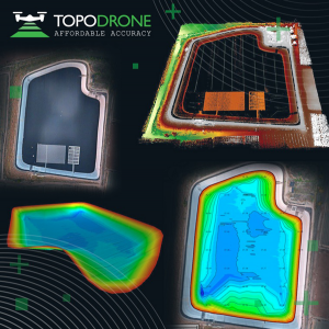
All data collected from the study was processed by TOPODRONE Post Processing software. This generated a georeferenced orthophoto map, a 3D model of the relief and objects, a 3D model of the bottom of the reservoir and a model of contour lines and isobaths.
TOPODRONE, a Swiss-based designer and manufacturer of high-precision lidar equipment for installation on drones, vehicles and backpacks, launched AQUAMAPPER, a UAV-based solution for bathymetric surveying and marine construction.
AQUAMAPPER contributes to a complete set of photogrammetry, lidar and bathymetry surveying solutions from TOPODRONE. The product, compatible with the DJI Matrice 300 RTK, provides a combination of high-speed efficiency (up to 14 km/h) and accuracy mounted on a UAV. The application areas include an open sea bathymetric survey up to 100m depth, quantity survey and calculation of sediments and periodic maintenance survey of storage pools.
Photo: TOPODRONE
The new data-collecting device has been successfully used alongside TOPODRONE’s LiDAR ULTRA equipment for airborne surveying at a highway construction project in one of the toughest terrains in Romania, EU, including 7 tunnels, 24 bridges and 18 viaducts. The project was performed by the Romanian company GRAPHEIN TOPO SA to deliver a full digital twin of a studied area.
Photo: TOPODRONE
The TOPODRONE LiDAR ULTRA on board a DJI M300 drone was used to capture laser scanning data from an altitude of 100 m to 120 m over rugged terrain forest area to cover a corridor 32 km long and 400 meters wide in 14 flights while AQUAMAPPER connected to the same DJI M300 drone performed a bathymetric survey over six river crossings.
“The key advantage of the new bathymetric equipment from TOPODRONE is the ability to capture a riverbed with centimeter-level accuracy with high speed in fully automatic mode and without using any boat,” said Andrei Sueran of GRAPHIEN TOPO SA. “The combination of an echosounder, GNSS and inertial measurement system helps to get accurate results after data post-processing.”
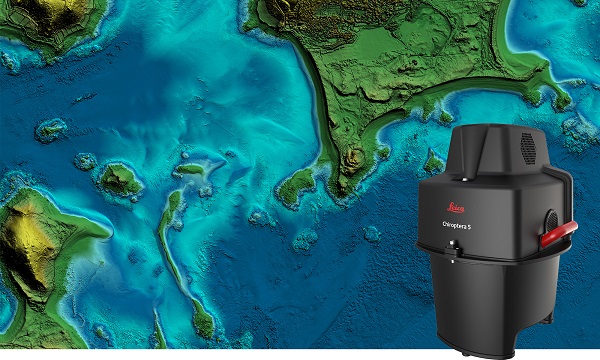
The new Leica Chiroptera-5 is a high-performance airborne bathymetric lidar sensor for coastal and inland water surveys.
Offered by Leica Geosystems, Chiroptera-5 provides 40% higher point density, a 20% increase in water-depth penetration, and improved topographic sensitivity for generating more detailed hydrographic maps.
The technology increases the depth penetration, point density and topographic sensitivity of the sensor compared to previous generations. It delivers high-resolution lidar data supporting applications such as nautical charting, coastal infrastructure planning, environmental monitoring and landslide and erosion risk assessments.
Chiroptera-5 combines airborne bathymetric and topographic lidar sensors with a four-band camera to collect seamless data from the seabed to land. With a higher pulse repetition frequency (PRF), the new technology increases point density by 40% compared to the previous generation system, collecting more data during every survey flight.
Improved electronics and optics increase water-depth penetration by 20% and double the hydrographic sensitivity to capture larger areas of submerged terrain and objects with greater detail. The high-performance sensor is designed to fit a stabilizing mount, enabling more efficient area coverage, which decreases operational costs and carbon footprint of mapping projects.
Leica Geosystems’ signature bathymetric workflow supports the sensor’s performance. Introducing near real-time data processing enables coverage analysis immediately after landing, allowing operators to quality control the data quickly before demobilizing the system.
The Leica Lidar Survey Studio (LSS) processing suite provides full waveform analysis and offers automatic calibration, refraction correction and data classification, as well as advanced turbid water enhancement.
Supporting environmental research
Combining superior resolution, depth penetration and topographic sensitivity, Chiroptera-5 provides substantial benefits for various environmental applications such as shoreline erosion monitoring, flood simulation and prevention, and benthic habitat classification.
Bundled with the FAAS/EASA-certified helicopter pod, the system enables advanced terrain-following flying paths for efficient river mapping and complex coastlines surveys. Owners of previous-generation systems are offered an easy upgrade path to Chiroptera-5 to add capabilities to their existing sensor and leverage their initial investment.
“The first-generation Chiroptera airborne sensor was flown in 2012. During its 10 years of operation, the system has seen constant evolution that continuously improved the productivity and efficiency of the entire bathymetric surveying industry,” said Anders Ekelund, vice president of airborne bathymetry at Hexagon. “By collecting detailed data of coastal areas and inland waters, Chiroptera-5 provides an invaluable source of information that supports better decision making, especially for environmental monitoring and management, in line with Hexagon’s commitment to a more sustainable future.”
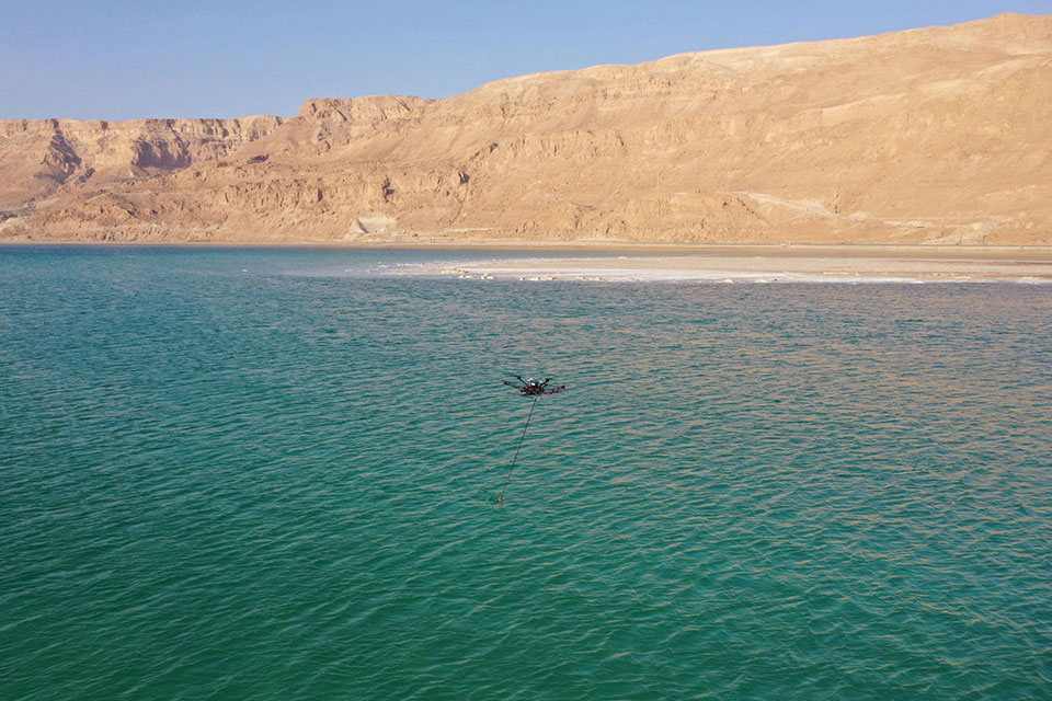
A drone equipped with an echo sounder surveys the Dead Sea. (Photo: SPH Engineering)
Israeli drone service provider ERELIS has conducted a number of pilot projects using a drone equipped with a single-beam echo sounder in the Mediterranean Sea and the Dead Sea. The data was validated by authorized local surveyors and reports from previous surveys of the same areas by the Michmoret Campus, Faculty of Marine Science.
The reference bathymetric data was collected using a manned boat and multi-beam and single-beam echo sounders and demonstrated a good match between the results of new drone-based and traditional methods.
The bathymetric system consisted of a standard commercial DJI drone (UgCS SkyHub onboard computer and terrain-following system with radar altimeter) and Echologger ECT400 single-beam echo sounder provided by SPH Engineering, Latvia. For data processing, the Eye4Software Hydromagic software package was employed.
“I was surprised by the maneuverability of the system and how easy it is to conduct bathymetric surveys using a UAV equipped with an echo sounder,” said Roman Kirsanov, CEO of ERELIS. “Some of our survey areas were 400 to 500 meters away from take-off and landing positions, and that means that remote sensing comes to the world of hydrography and becomes available to any drone service companies.”
Screenshot: SPH Engineering
“It was good to see that applicability of our system with a single-beam echo sounder validated in conditions outside of its initial focus on small-scale surveys of inland water bodies,” said Alexey Dobrovolskiy, CTO of SPH Engineering. “We can now recommend our system for small-scale surveys in coastal areas and virtually in any liquids. The density of water in the Dead Sea is 1.24 kg/l.”
In May, SPH Engineering launched a UAV integrated with an echo sounder, as a new product for bathymetric surveys of inland and coastal waters. This data-collection method has since been used in Denmark and the UAE, and is suitable for mapping, measuring and inspections, as well as environmental monitoring.
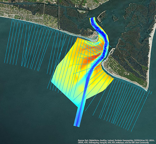
Multi-beam bathymetry and topo/bathy beach profiles of the Cape Fear River Inlet (USACE Wilmington). (Image: NV5 Geospatial)
Following its March 29 acquisition of Geodynamics LLC, NV5 Geospatial has built a comprehensive suite of solutions for geospatial surveys of deep-water and near-shore environments. Geodynamics will operate as a wholly owned subsidiary of NV5 Global as part of the NV5 Geospatial group.
The acquisition brought together complementary, advanced technologies — Geodynamics’ full ocean-depth sonar-based hydrographic and geophysical surveying with NV5 Geospatial’s topographic and bathymetric capabilities. Together, the technologies deliver detailed insights for a variety of applications, including coastal management, flood monitoring, ecosystem protection, research and more.
“This acquisition was a natural evolution toward our common goal of delivering valuable geospatial insights to our clients,” said Kurt Allen, vice president, Federal Vertical for NV5 Geospatial, powered by Quantum Spatial. “Our decades’ of combined experience and expertise using the most sophisticated technology for data acquisition and analysis will enable us to meet the most demanding client requirements.”
Geodynamics is a pioneer in collecting and processing single-beam, multi-beam, sidescan, geophysical and acoustic backscatter hydrographic data in some of the most challenging coastal environments, including dynamic tidal inlets, high-energy surf zones, and rapidly changing shoal systems that challenge navigation.
Geodynamics has completed large-scale hydrographic survey projects in the coastal and adjacent ocean areas of the entire United States, including detailed hydrographic surveys to support federal nautical chart updates in the Atlantic, Gulf of Mexico and Great Lakes region for the Office of Coast Survey of the National Oceanic and Atmospheric Administration (NOAA).
With a research focus on coastal geology, Geodynamics’ offshore geophysical surveys have supported mapping of marine minerals, benthic habitat and identification of potential submerged archaeological resources.
The relationship between the companies began with a joint venture in 2019. Working collaboratively as MarineGeoSpatial LLC, the partnership provided aerial- and ship-based remote sensing for offshore/marine survey and data collection, mapping and data analysis, and marine enterprise GIS services.
“We are excited to embark on this new chapter with NV5,” said Geodynamics CEO Sloan Freeman, PLS. “It is the perfect strategic alignment of aerial, subsea survey and geospatial services. Together, we have the technology, tools and experience to provide the best solutions to our clients and continue to advance scientific knowledge about coastal environments.”
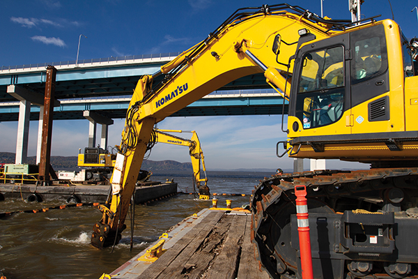
Trimble hardware and software tracked the position and motions of the machines and displayed to the operators the position of their tools underwater. (Photo: Trimble)
A new, twin cable-stayed bridge was built a few yards north of the original bridge by Tappan Zee Constructors LLC (TZC), a consortium of firms. The Left Coast Lifter — a huge crane on a barge previously used to replace a span of the San Francisco-Oakland Bay Bridge — was used to install groups of pre-assembled girders one full span at a time. Construction of the new bridge and demolition of the old one overlapped, with the entire project completed in May 2019.
The project was huge, complex and on an accelerated schedule. “Challenges included the size of the bridge, the river’s current, tidal variations, the water’s turbidity and strong winds,” recalled Jonathan White, product manager for Trimble Civil Construction Field Solutions, Marine. Conditions were particularly challenging for bathymetric data collection before and during the project. “The low visibility in the water made it a prime situation for sonar technology to play a major role.”
A licensed surveyor conducted a pre-dredge bathymetric survey, which was loaded into the construction software as a baseline. Trimble hardware, software and technical advice supported the demolition of the old bridge.
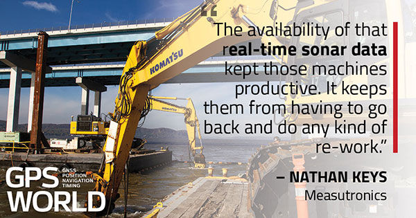
“As they were beating down the bridge with the jack hammers and trying to pick up the rubble from the river with the cranes, the main challenge was to keep the 11 machines that they had updated in real time with the most accurate 3D data, so that they could keep working,” explained Nathan Keys, a geospatial engineer at Measutronics, a Trimble dealership and project lead for the Tappan Zee Bridge project.
Rather than mount a sonar to the front of each construction barge, they used a single survey vessel to serve the machines (eight excavators and three clamshell cranes) with real-time data, using networked connections to update one machine at a time.
Whenever a crane operator thought he was done in an area — the machine guidance display in his cab told him that he had achieved the design depth — the survey boat would verify that, and either give the operator the go-ahead to continue working or point out any spots that were still too high or too low. “That way, they would avoid having to return to an area, which costs time and money,” Keys said.
Trimble equipment provided the positioning of the machines, tracked their motions, and visualized them, enabling the operators to “see” underwater where their bucket, grapple tool, clamshell, or other tool was operating. Trimble supported its dealer and the consortium that was executing the project, White said. “Measutronics is very well versed in the capabilities of Trimble equipment and, more broadly, marine construction workflows generally. If a piece of their equipment went down, we could swap something out and provide them with any support that they needed, and expedite that support because we knew how crucial it was with them being in the field pretty much 24/7.”
Marine excavation. The survey vessel was equipped with a Teledyne RESON T-20 multibeam sonar and a Trimble Applanix POS MV WaveMaster for motion and position. “The eight excavators were equipped with a Trimble marine excavator guidance package, which includes a GPS receiver and angle sensors working together to give guidance to the tool, whether it is a jack hammer, a bucket or whatever,” said Keys. “They also had three clamshell cranes with rotational encoders on the wire-out drums, to keep track of the bucket’s vertical. The central piece to all this is the Trimble Marine Construction software, which takes in the data from all the sensors, including the sonar, in real time and updates the display in the cabin.”
To install its sensors on machines, Trimble provides flexible aftermarket kits that come with weld plates. “We just point out to the customer where to weld the plates, then we will put the sensors on, run the cables to the cab, and do all the wire runs,” Keys explains. “It does not matter whether it is a Caterpillar or a Kobelco or whatever. They are aftermarket systems, so they can go on pretty much any machine.”
This project, Keys clarified, involved only machine guidance, not automation. “We were not using any of the machines’ own sensors. We showed them where they were and then the operator would have to control it.”
Trimble provided precise position and heading, White said. “Through a very accurate measure of where each of these sensors is installed relative to the phase center of the GPS antenna, we can determine how the machine is moving and measure that movement, so that we know exactly where the tool is relative to the position that we are getting from our satellite trilateration. It is not like the guy is sitting in the seat drinking a cup of coffee while the machine parallel parks itself. However, he is receiving a lot of information from all those sensors as to his tool’s position relative to that GPS location.”
Keys said the machines constantly log the data and their movements while they are running. “We can go back into those log files and pull out whatever we want,” he said. “On the survey side, when they do a scan or a survey of an area, that data is captured as a 3D point cloud of what the bottom looks like, which you can import into any software to visualize and quantify the riverbed and the rubble.
“The availability of that real-time sonar data kept those machines productive,” Keys said. “It keeps them from having to go back and do any kind of re-work.”
White said the technology is getting more affordable and user-friendly. “That is leading us, as a manufacturer, to look for ways to help further bring it into our standardized workflows. We have been working with Teledyne on those objectives.”
Trimble is also keen to advance the networking component, specifically to the marine sector, White added. “It is relatively new to marine construction projects. The ability to have a sonar vessel speaking to a machine, and all the machines to speak to each other, and to share a survey file is a very important objective for us.”
Dundrum Bay on the coast of Northern Ireland is captured by a mapping airplane in a project to document climate change effects. (Photo: DAERA/Bluesky)
Bluesky International will use aircraft-mounted lidar sensors and laser scanners to create a highly detailed 3D map of the whole of the Northern Ireland coastline.
Working on behalf of the Department of Agriculture, Environment and Rural Affairs (DAERA), the lidar survey will be used to create the first complete baseline. The baseline will underpin recording of coastal change and help identify the rate at which the coastline is changing as a result of climate change.
In addition to the lidar data Bluesky will simultaneously capture high detailed aerial photography which will be processed to produce to a fully orthorectified, 10-centimeter-resolution database.
The Bluesky data will form part of the wider Northern Ireland 3-dimensional coastal survey. The survey will extending into the marine environment with a satellite-derived bathymetric survey and a pilot bathymetric lidar survey. Together, the surveys will inform the development of future coastal management policies.
“The Northern Ireland coast is a hugely valuable resource which is currently facing increasing pressure from climate change,” said Joanne Hanna, senior scientific officer within the Marine and Fisheries Division of DAERA. “Sea-level rise, in combination with an increase in extreme storm events, is resulting in greater energy impacting our coastlines, altering coastal processes and accelerating change.
“Despite the importance and the value of this coastline, the nature and scale of the issues arising from coastal change and sea-level rise are currently not known and there is limited and insufficient baseline data available,” Hanna said. “The coastal lidar survey carried out by Bluesky will provide scientifically robust baseline data which will enable decision makers and coastal managers to make informed decisions and devise solutions and appropriate management to the problems currently facing our coastline.”
Bluesky will undertake the specialist survey using a fixed wing manned aircraft and will fly the 763 kilometres of Northern Ireland coastline capturing height measurements of both the underlying terrain and any surface features at a resolution of better than 16 points per metre. This data will be used to create highly accurate 3D digital terrain and surface models (DTM, DSM) with a spacing of up 25 centimetres.
The Bluesky datasets will be supplied ready for use in a range of geographical information system (GIS), desktop mapping and other specialist software packages and will be compatible with other DAERA datasets including Ordnance Survey mapping.
SPH Engineering has launched a product designed to conduct bathymetric surveys of inland and coastal water.
The system — an unmanned aerial vehicle (UAV) integrated with an echo sounder — is time- and cost-efficient, the company said. It is suitable for mapping, measuring and inspecting tasks as well as environmental monitoring.
The system allows field workers to collect data with high accuracy quickly. It is easily transported, quickly deployed and twice as cost-efficient as traditional methods.
The UAV/echo sounder system can be operated in hard to reach locations, and unsafe or hazardous environments. Locations not reachable by foot or that are dangerous for a human (steep coasts, mining pits, contaminated waters, terrain obstacles, etc.) as well as waters of ponds, lakes, and canals can be reached by the drone.
“Since autumn 2018 we have been getting bathymetry-related requests,” said Lexey Dobrovolskiy, CTO of SPH Engineering. “Analyzing about 150 inquiries, we have come to the conclusion that a drone-based solution could open a new business opportunity for drone service companies to do bathymetry surveys of coastal and inland water, especially those for industrial needs.
“Compared with a standard approach using a boat or an unmanned surface vehicle, a drone could save a lot for its user,” Dobrovolskiy said. “An echo sounder itself could be integrated into a client’s drone with no need to purchase additional equipment. Moreover, it is small and easy to transport and operate. At the same time, such research method guarantees data accuracy and employee safety.”
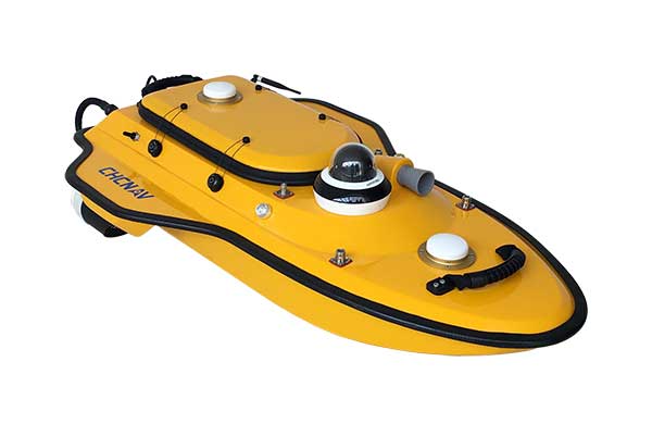
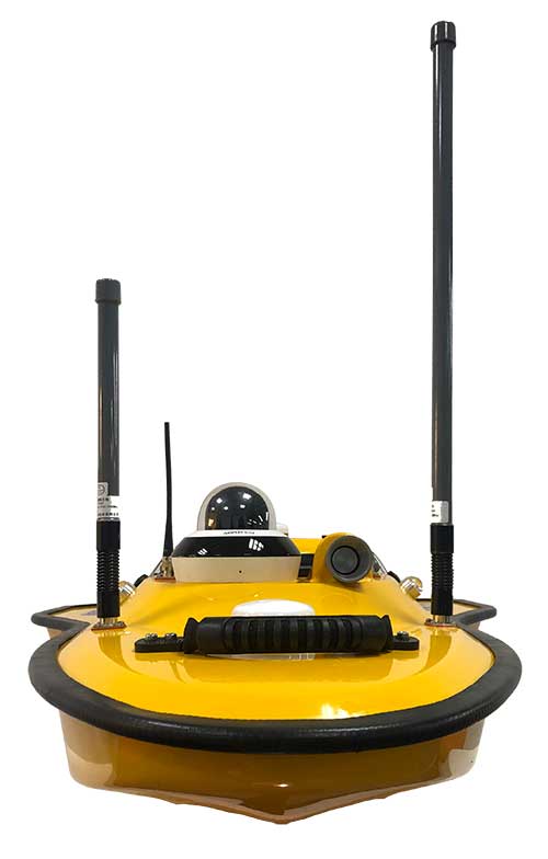
Highly cost-effective autonomous marine drone for bathymetric surveys
Photo: CHC Navigation
The new Apache3 Marine Drone — 2020 Edition provides a series of new features and additional enhancements to make lake, river and coastal hydrographic surveys more productive, according to maker CHC Navigation.
Combining a dual GNSS positioning and heading sensor, a stable and reliable hull attitude and an inertial measurement unit (IMU) sensor, the Apache3 unmanned surface vehicle (USV) allows an uninterrupted survey while passing under bridges.
Its high-efficiency 8-meters-per-second motors and absolute straight-line technology enable a fully automatic, predetermined course in adverse current conditions.
The Apache3 features include:
GNSS/INS control box to maintain high accuracy during transient GNSS outage
Integrated 4G and LAN transmission module
Sonic radar for obstacle avoidance
Automatic return to base planning
360° PTZ camera (pan, tilt, zoom)
Overspeed engines to allow operation in most water conditions
According to CHC Navigation, the Apache3 — 2020 Edition offers an exceptional feature/price ratio, making it one of the most competitive professional marine UAV solutions for single-beam bathymetric surveys.
Drones are quickly becoming a staple of the maritime industry. In January, the European Maritime Safety Agency (EMSA) issued the largest ever civilian maritime drone contact, valued at €67 million.
Under the contract, drones will be used to assist with border control, search-and-rescue operations and monitoring of pollution, as well as the detection of illegal fishing and drug and people trafficking.
External Vessel Inspections. Big names in the maritime industry such as DNV-GL, Lloyds Register and Maersk have all shown strategic intent to revolutionize their operations by embracing drone technology, and many maritime operators are now following suit.
All ship owners know that traditional methods of external vessel inspection can be a costly affair. Now that high-definition, camera-equipped drones are widely available and affordable, it is becoming more common to use them for external vessel inspections to assess structural conditions. Identifying substantial corrosion, significant deformation, fractures, damage or other structural deterioration can be done quickly, easily and cost-effectively using drones.
Tank Inspections. The visual inspection of cargo tanks was traditionally performed by workers suspended on ropes to inspect the tank structure. The sheer size of modern-day vessels means that access methods including staging, rafting and climbing are often used by surveyors to access tanks.
In contrast, drone surveys require no human access to the tank and, since no access equipment is required, there are no setup costs, and inspections can be completed within a quicker timeframe.
Martek Marine’s V-200 UAS. (Photo: Martek Marine)
Bathymetric Surveys. Accurate and reliable information on the features of water bodies and their shorelines is vital to navigational safety. Bathymetric surveys gather the information, which is then published for use on nautical charts. Rather than using a fixed-wing airplane or helicopter, bathymetric sensors developed for drones allow this type of survey to be carried out flexibly and at a fraction of the cost.
To operate effectively in the harsh maritime environment, the technology has been developed to withstand storm force wind and heavy rain, snow and salt spray.
As technology advances, so does the flight time available on drones, meaning more area can be covered in a quicker timeframe.
Floating Flare-Tip Inspections. Drone surveys typically exist to provide close visual and thermal inspections of high, live or difficult to access structures offshore, and there’s nothing more challenging to access than a flare tip, 70 meters above water, on a floating production facility.
Drone survey inspections for flare tips remove the need for a shutdown to inspect the flare and offer reduced costs compared to aerial surveys carried out by helicopter or plane.
Offshore Wind Energy. The wind energy sector is growing fast. Storm force winds, erosion, lightning strikes and even build-up of insects can have an impact on turbines, and blades need to be inspected for deterioration. Inspectors have traditionally had to scale the turbines with the help of ropes and cables.
The maritime surveying company Martek Marine uses a drone fleet designed for turbine-blade inspections onshore or offshore. Qualified and trained pilots quickly and accurately identify and assess faults.
Traditional surveying requires turbines to be offline for two hours up to a day, but Martek’s inspection process reduces this time to 45 minutes.
Following the inspection, the client can access the data through Martek’s secure, cloud-based asset management portal where they can download a detailed PDF report and access raw survey data.
Fully Autonomous Drones? Fully autonomous drones could be the next big thing for maritime surveying. The drones can be pre-loaded with a 3D model of the ship. This allows the drone to autonomously work its way around the vessel, stopping at points of interest to obtain detailed video or image data.
Advancing this further, a drone could be designed to create its own 3D map of the vessel before carrying out the survey independently.
This article is excerpted from a blog by Martek Marine, a UK-based maritime surveying company. Read the full blog, with more details and examples.
Fugro has been awarded a supply arrangement by the Canadian Hydrographic Service (CHS) to provide vessel-based hydrographic survey services. Under the contract, CHS will procure hydrographic surveys as needed, anywhere in Canada, to enhance its capacity for data acquisition and processing in support of its nautical charting program.
Hydrographic survey data from ports, harbors, nearshore and offshore regions will be acquired and processed using Fugro’s vessels, equipment and personnel. The resulting data will be used by CHS to update its nautical charts.
The supply arrangement, together with a supply arrangement for airborne lidar bathymetry (ALB) awarded in 2013, will enable Fugro to support Canada in its plans to implement an integrated multi-platform methodology to hydrographic surveying anywhere in Canada, including the Arctic region.
Fugro provides International Hydrographic Organization (IHO) compliant survey services to numerous governments throughout the world.
Fugro has extended its integrated survey services to help improve efficiency in coastal management and enable more informed decision-making. A new agreement with global specialist EOMAP enables the creation of integrated bathymetric survey products that comprise elements from Satellite Derived Bathymetry (SDB), Airborne LiDAR Bathymetry (ALB) and traditional acoustic survey technologies. The integrated data and product solutions will provide clients with outstanding value and unmatched coverage, Fugro said.
“Teaming with EOMAP augments our considerable survey and satellite imagery capabilities and will allow a timely and cost-effective nearshore bathymetry review facility for clients whose own bathymetric holdings are either very old or very sparse — or both,” said Don Ventura, hydrographic business development manager at Fugro. “This service will help coastal zone management and engineering teams, environmental scientists and hydrographic agencies to focus on their immediate needs and to make more informed decisions on subsequent, efficient data acquisition and management.”
EOMAP’s robust technology platform can process satellite images and deliver global bathymetric and benthic habitat data over the full range of temporal and spatial resolutions through its proprietary, sensor-independent Modular Inversion Processor (MIP). This both complements and augments services already provided by Fugro, to provide even more spatial data solutions to suit a wide variety of budgets and purposes.
“We are very pleased to provide our Satellite Derived Bathymetric products and services to Fugro,” said Matthew Bergin, Vice President of Business Development at EOMAP. “We believe that this agreement will create a unique, one-stop technology resource to meet the demanding requirements of both commercial and government customers.”