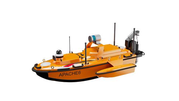
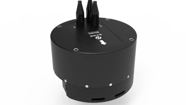
CHC Navigation (CHCNAV) has released the Apache 6–2026 Edition, an integrated unmanned surface vessel (USV) designed for high-resolution bathymetric and 3D mapping applications. Built to accommodate NORBIT multibeam echosounders, the Apache 6 delivers a comprehensive solution for underwater surveying, object positioning, and offshore construction support in varying aquatic conditions.
The Apache 6 – 2026 Edition is optimized for seamless integration with the NORBIT iWBMS and WINGHEAD series of multibeam echosounders. An optional NORBIT iLiDAR can also be integrated, allowing for the simultaneous collection of marine and terrestrial 3D data in a single pass. This capability is particularly efficient for projects that require mapping both underwater topography and overhead structures, such as bridges and power lines, making it a comprehensive tool for harbor, river and infrastructure surveys.
Automated Sound Velocity Profiling Accurate sound velocity measurement is fundamental to high-quality bathymetric data. The Apache 6 – 2026 Edition addresses this with an optional automated sound velocity profiler (SVP) kit. This system can be controlled directly from the remote controller, allowing the operator to perform SVP casts on-demand without interrupting the survey workflow. The kit is designed for rapid deployment — attachable or detachable in under a minute — ensuring that the multibeam echosounder data is continuously corrected with the most accurate sound speed information, which is critical for meeting stringent survey specifications.
The USV combines a detachable triple-hull vessel design with smart rotating propeller technology to deliver both stability and agility in varied conditions. The robust hull configuration ensures reliable performance in strong currents, while removable side floats enable safe operations in shallow waters. Intelligent propeller control adjusts water flow direction to achieve a turning radius of approximately two meters, supporting effective navigation in confined or winding channels.
Android-Based Control Survey operations are streamlined through an intelligent Android remote controller, which provides real-time access to vessel status and data without the need for a separate field computer.
The interface allows for straightforward management of the survey workflow, while a multi-link communication system ensures reliable data transmission over long distances. This setup enables surveyors to maintain seamless control over the Apache 6 and monitor mission progress effectively from the shore.
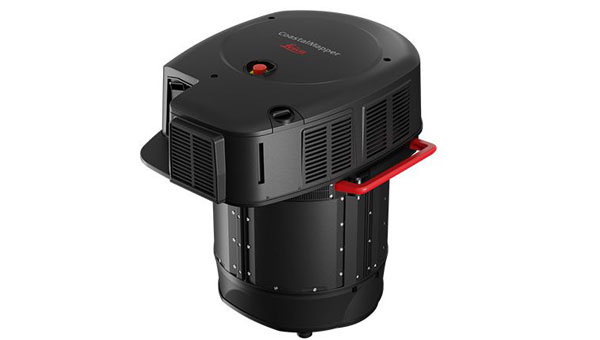
NV5, a division of Acuren Corporation, has become the first geospatial company to acquire and deploy Hexagon’s Leica CoastalMapper, an airborne bathymetric lidar system for coastal and riverine mapping.
The CoastalMapper, developed by Leica Geosystems, combines a bathymetric lidar module with topographic lidar and an imaging sensor in a compact pod. The system collects bathymetric and topographic lidar data simultaneously with high-resolution imagery during a single flight. It captures up to 1 million bathymetric points per second and 2 million topographic points per second, producing imagery at a 5-centimeter ground sampling distance at standard flying altitudes.
The system can operate at higher altitudes than previous generation systems, enabling surveys of steep mountainous river terrain. Applications include infrastructure resilience, flood monitoring and environmental investigations in shallow and deep waters.
Kurt Allen, president of NV5’s Geospatial Business Unit, said the sensor system will allow the company to deliver more comprehensive datasets in coastal and riverine environments and support environmental resilience and infrastructure planning.
NV5 Geospatial will receive the Leica CoastalMapper from Hexagon by the end of the year, with a handoff that took place at Intergeo in Frankfurt, Germany, Oct. 7-9, 2025.
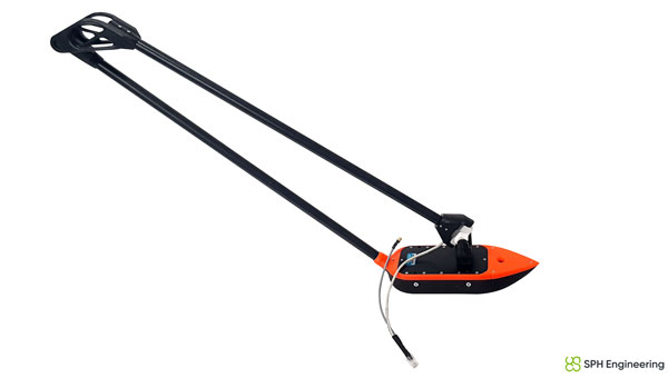
SPH Engineering has released a multibeam echosounder system for UAVs that uses the Cerulean Surveyor 240-16, a compact bathymetric sensor designed for shallow-water mapping.
The system expands drone-based hydrographic surveying capabilities by providing high-resolution bathymetric data collection over shallow waters. The Surveyor 240-16 operates at 240 kHz with a measurement range of 0.5 m to 50 m, targeting inland waterways, reservoirs, ports and environmental monitoring locations.
The multibeam system generates an 80° cross-track swath with a 16-element receive array and 1° angular resolution, allowing operators to map wider bottom coverage compared to traditional single-beam payloads.
The payload integrates with SPH Engineering’s UgCS flight planning software and SkyHub onboard computer for automated missions. Weighing 2.4 kilograms with all components and consuming 15 watts of power, the system works with UAVs including DJI M300, M350 and M400 models, as well as Inspired Flight IF800 and IF1200 aircraft.
SPH Engineering conducted field validation at Titutga Lake in Latvia in August 2025. Survey flights operated at an average speed of 1.2 m per second, balancing data collection density with UAV battery endurance.
Testing compared the multibeam system’s performance against single-beam payloads, which engineers noted remain useful for quality control verification of multibeam datasets. The combined approach demonstrated capabilities for high-resolution mapping in areas previously difficult to access with boat-based systems.
Software compatibility includes full support in BeamworX, with Hydromagic integration planned for future releases.
“The payload based on Cerulean Surveyor 240-16 represents a milestone in drone-based bathymetry,” said Alexey Dobrovolskiy, CEO of SPH Engineering. “By combining multibeam technology with UAV platforms, we are enabling hydrographers to collect dense bathymetric datasets at a fraction of the time and cost of conventional systems. This integration opens new opportunities for surveying reservoirs, lakes, and coastal areas that were previously inaccessible or unsafe.”
SatLab has introduced the HydroBoat 1200MB, a compact uncrewed surface vehicle (USV) system engineered for 3D hydrographic surveying in inland and nearshore waters. The system integrates SatLab’s autonomous vessel platform with the HydroBeam M2 multibeam echosounder, providing a portable solution intended to streamline data collection in shallow or confined environments.
The HydroBoat 1200MB is developed as a fully integrated unit, combining navigation, sonar data acquisition, real-time visualization and data management. According to the company, it is designed to assist small teams in conducting geospatial reconnaissance and hydrographic assessments with minimal setup and reduced operational complexity.
SatLab reports that the system supports a seamless workflow, from survey planning through to the delivery of final results. The vessel features an integrated inertial navigation system that delivers roll, pitch and yaw measurements without requiring field calibration. Its real-time data visualization capabilities allow users to view high-resolution 3D point clouds, bathymetric profiles and sidescan imagery across multiple devices, which allows for immediate quality control and decision-making in the field.
The HydroBoat 1200MB incorporates SatLab’s proprietary sound speed profile inversion technology, which enables real-time sound velocity correction without the need for separate sound velocity profilers. The system is designed for operational efficiency, with deployment possible in under five minutes and control managed through an Android-based interface.
Equipped with a multibeam configuration offering 512 beams and a swath coverage of 30 to 150 degrees, the HydroBoat 1200MB is intended to allow users to survey larger areas compared to singlebeam alternatives. According to SatLab, this configuration can result in up to a 7.5-fold increase in survey efficiency and potential cost reductions of up to 50%, due to the elimination of auxiliary equipment and simplified field operations.
The HydroBoat 1200MB can be used in a variety of applications, including river and reservoir surveys, bank mapping, structural inspections, sediment transport monitoring and infrastructure assessment. It is designed to meet data quality standards set by the International Hydrographic Organization, the Canadian Hydrographic Service and the U.S. Army Corps of Engineers.
Hydro-Tech has unveiled the MS400C, a fully integrated multibeam echosounder designed for uncrewed surface vessels. The new system combines sonar processing, inertial navigation, GNSS positioning and sound velocity sensing into a single unit.
The MS400C seeks to address deployment challenges faced by USV operators during hydrographic surveying. Its compact, lightweight design allows direct mounting on small platforms. Installation involves connecting a few cables to the IPC and power supply and to the primary and secondary GNSS antennas. With preconfigured spatial relationships, operators can deploy and start surveying quickly, reducing configuration errors and ensuring consistent data quality. Equipped with Auto Survey functionality, the system calibrates parameters based on water conditions, which streamlines pre-survey procedures. Real-time roll compensation and attitude data from the internal IMU, combined with sound velocity profiling, ensure high-fidelity depth measurements, even in dynamic conditions. Designed for autonomous and remotely operated survey platforms, the MS400C supports data collection in confined waterways.
Leica Geosystems, part of Hexagon, has introduced the Leica CoastalMapper, an airborne bathymetric lidar system designed for coastline and river surveying. The system offers a wider field of view and the ability to operate at higher altitudes. As a result, the CoastalMapper can survey coastlines and rivers 250% faster than previous sensor models.
The CoastalMapper is suitable for a wide range of mapping applications, from assessing infrastructure resilience to monitoring river floods and conducting environmental investigations in both shallow and deep waters.
It features a combination of a high-performance bathymetric lidar module, a Leica TerrainMapper-3 topographic lidar and an imaging sensor, all integrated into a compact and lightweight sensor head. This allows the CoastalMapper to capture up to 1 million bathymetric data points and 2 million topographic data points per second while providing high-resolution imagery with a 5 cm ground sampling distance at typical flying heights.
One of the key advantages of the CoastalMapper is its ability to collect bathymetric and topographic lidar data and imagery in a single flight. This simultaneous multi-data capture seeks to significantly reduce survey time, operational costs and the environmental impact of each mission. Additionally, it can be mounted on helicopters, allowing for surveys in challenging environments such as rivers in steep mountainous terrain.
The CoastalMapper seamlessly integrates with Leica Geosystems’ airborne mapping workflows. It also offers cluster processing capabilities, allowing users to analyze large datasets and reduce the time from data collection to final deliverables. These outputs can include classified point clouds, digital terrain and surface models, and various imaging products, making the CoastalMapper a comprehensive solution for a wide range of mapping needs.
Nearly three quarters of Earth’s surface is covered by water, yet only about a quarter of that surface has been mapped in detail using modern high-resolution technology.
Marine experts worldwide work together to chart the ocean floor, ensuring the safety of ports, harbors and navigable routes. This effort is crucial for global trade, as more than 90% of goods are transported by ships. Ocean floor surveying also supports the installation of offshore infrastructure such as fiber optic cables, pipelines, drilling platforms and wind turbines.
The increasing population in coastal regions and rising sea levels due to climate change have heightened the importance of observing coastal transformations, erosion and other marine alterations. These factors are essential for understanding and protecting coastal ecosystems.
Mapping techniques
In deep waters, massive multi-beam echo sounders (MBES) operating at very low frequencies collect depth data. As water depth decreases, smaller devices with higher frequencies and resolution must be used. However, near the shore, these devices become less efficient due to the slope of the shelf interfering with sound signals.
In near-shore scenarios, collecting depth data is best done using airborne lidar sensors, which offer several advantages over sensors on surface vessels. One advantage of airborne sensors is that they can simultaneously map both the seafloor and the adjacent topography to offer seamless land-water transition data. This capability is particularly valuable in dynamic coastal environments where rapid coverage of large areas is essential.
Bathymetric lidar is specifically designed for mapping shallow coastal waters, typically effective up to depths of 50 m. It can provide high-resolution data, often achieving sub-meter positional accuracy, which is crucial for detailed coastal mapping. By combining MBES for deeper waters with lidar for near-shore areas, researchers and surveyors can create comprehensive and accurate maps of the entire coastal zone. This method offers an in-depth understanding of underwater topography, aiding various applications in marine science, coastal management and navigation.
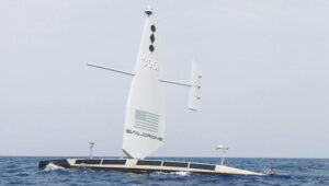
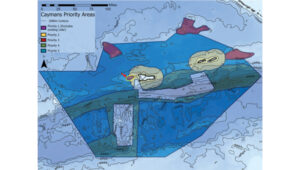
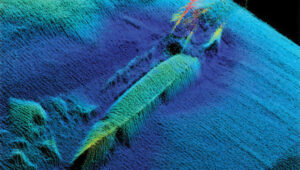
The waters of the Cayman Islands are abundant in marine life, featuring coral reefs, seagrass beds and a variety of fish species. A high-resolution map of the seafloor is essential to begin exploring, identifying, characterizing, exploiting, conserving and managing ocean resources. Saildrone has begun a mission to map 29,300 square nautical miles (100,490 sq km) of the Cayman Islands’ Exclusive Economic Zone (EEZ). This mission uses autonomous technology to survey 80% of this EEZ.
The Cayman Islands EEZ, extending up to 200 nautical miles from shore, encompasses an area nearly half the size of Florida — and 380 times greater than the island itself. The mission will provide detailed and precise bathymetric data for this area, contributing to a comprehensive understanding of the seafloor topography in the region. The data collected seeks to enhance maritime navigation and support scientific research, environmental conservation efforts and marine resource management in the Cayman Islands.
“Our waters hold such great value to us for a myriad of reasons, ranging from recreational to economic. Conducting this assessment will allow our government to make data-driven decisions that will strengthen our policies and legislation as it relates to our maritime infrastructure,” said Juliana O’Connor-Connolly, premier and minister for District Administration and Lands.
The Saildrone Surveyor USV is a purpose-built platform for autonomous deep-water ocean mapping. (Photo: Saildrone)
The mission is philanthropically funded by the London and Amsterdam Trust Company Limited, a Cayman-based organization. Saildrone is tasked with collecting the raw bathymetry data, which will be provided to the UK Hydrographic Office to process and update the Cayman Islands’ nautical charts. The data will belong to the government of the Cayman Islands.
Autonomous seafloor exploration
The mission is being conducted using a 20-m Saildrone Surveyor uncrewed surface vehicle (USV) equipped with MBES and metocean sensors for ocean mapping and ecosystem monitoring, as well as radar, cameras and advanced machine learning. Metocean stands for meteorology and physical oceanography. Globally, only 26% of the ocean has been mapped, a result of the lack of survey ship capacity. While a survey ship takes years to build, Saildrone can produce one Surveyor in as little as six weeks.
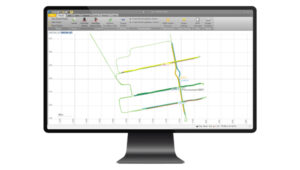
This nautical chart shows the Cayman priority mapping areas. The yellow oval indicates the vessel’s location as of Dec. 9, 2024. (Photo: Saildrone)
Saildrone USVs have demonstrated a reduction of more than 97% in operational carbon emissions when compared to survey ships to accomplish the same task. Additionally, they lower the risk to personnel. This information is highlighted in Saildrone’s Carbon Impact Report, which provides a comprehensive evaluation of the carbon emissions associated with maritime data collection and the emissions mitigated by using Saildrone’s USVs.
Saildrone’s ocean mapping solutions support storm surge modeling efforts and emergency response, as well as coastal resiliency and hazard studies, resource management, restoration projects, habitat mapping and infrastructure for renewable energy generation. USVs equipped with deep ocean mapping sonars now serve as a reliable option for data collection in large areas such as EEZs.
Bathymetry is crucial to understanding Earth’s aquatic environments. Its importance has evolved significantly since the early days of navigation, when mariners relied on lead lines and poles to gauge water depths. The field of bathymetry continues to advance with emerging trends that enhance data collection capabilities. Autonomous platforms such as USVs and autonomous underwater vehicles are increasingly utilized for bathymetric surveys, allowing for more extensive and detailed mapping. Additionally, as the industry grapples with challenges such as workforce shortages and the need for more efficient data collection methods, autonomous systems are proving to be a valuable solution.
Trimble’s Applanix POSPac MMS, an advanced GNSS-inertial post-processing software, seamlessly integrates with the Applanix POS MV and multibeam or sonar sensors to deliver high-accuracy results. (Photo: Trimble)
“Autonomous and uncrewed platforms have become a real force multiplier, and the trend continues,” said Peter Stewart, director of marine products at Trimble Applanix. “Companies such as XOcean and Saildrone are showing what is possible, leveraging cloud processing and enabling data collection in remote areas while maintaining a work-life balance for their staff. Since finding qualified engineers and surveyors to fill these roles offshore is an industry-wide concern, more flexible working conditions are needed to hire and retain talent.”
Another emerging trend is the development of sensors capable of penetrating murky waters, which can significantly enhance surveyors’ ability to gather data in challenging environments. Advanced sonar systems, innovative light-and-sound combinations and newly developed sensors allow research teams to collect detailed data. Post-processing technology for bathymetry has also significantly advanced, making data acquisition, processing and presentation more efficient and accessible. This allows researchers to map and study underwater terrains that were previously inaccessible or poorly understood.
Typical marine vessel data processed in POSPac MMS PP-RTX mode. (Photo: Trimble)
“Ease of use and installation are key trends toward ensuring valuable hydrographic data can be acquired, processed and presented efficiently,” Stewart said. Trimble works with users and third parties to offer an optimal workflow, making technology and the data it creates more accessible and operations more efficient, he added.
The IN-Fusion+ PP-RTX2 processing mode in Trimble’s POSPac MMS software is designed to improve post-processed GNSS-inertial trajectory generation. This mode uses Trimble’s CenterPoint RTX technology to deliver centimeter-level positioning accuracy without the need for local base stations. Stewart shared how this technology can be particularly useful when surveying around offshore windfarms, where shore-based RTK infrastructure is often too distant to be useable.
The Royal Navy has successfully tested a new quantum sensing technology designed for underwater detection. Conducted off the coast of Plymouth aboard HMS Magpie, the trials aimed to evaluate the effectiveness of this quantum-sensing system in identifying submerged objects.
The technology leverages ultra-cold atoms to measure subtle variations in the Earth’s magnetic field, which indicate underwater objects. This method allows for the detection of items that traditional sonar systems might miss, enhancing the precision of underwater surveys.
During the tests, the system identified various targets, including a concrete block weighing one ton, and demonstrated sensitivity sufficient enough to detect objects as small as a soccer ball.
This project is part of a broader collaboration involving the Royal Navy, the Defense Science and Technology Laboratory (Dstl) and industry partners. It reflects ongoing efforts to integrate advanced technologies into naval operations, aligning with the UK’s strategic focus on quantum technologies.
Future plans include further development and miniaturization of the quantum sensing system to enable its deployment on various naval platforms, such as ships and submarines, as well as autonomous underwater vehicles. The successful trials indicate that this technology could significantly improve the Royal Navy’s capabilities in maritime security and underwater exploration.
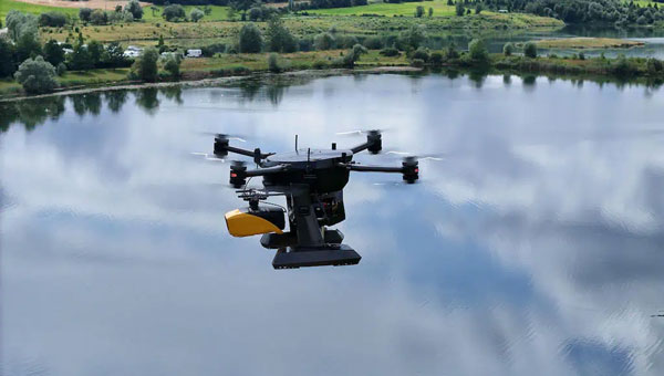
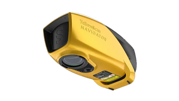
Xer Technologies and YellowScan have partnered to integrate the YellowScan Navigator bathymetric system into Xer Technologies’ UAVs. This collaboration aims to enhance UAVs’ capabilities for conducting long-range bathymetric surveys and underwater inspections, which are essential in various fields such as environmental monitoring, coastal management, and infrastructure development.
The integrated system allows users to collect high-resolution and accurate bathymetric data, even in challenging aquatic environments. YellowScan’s green laser lidar technology is a key component of this system, providing precise underwater mapping capabilities. Xer Technologies’ UAVs are designed for extended flight durations and can operate for more than two hours, facilitating coverage of larger survey areas in a single mission. This feature is particularly beneficial for projects that require extensive data collection over vast aquatic regions.
The YellowScan Navigator can achieve a precision of 3 cm and can operate at a maximum altitude of 100 m above ground level. The laser has a range of up to 120 m and features a scanner field-of-view of 44 °. It weighs 3.7 kg.
YellowScan has released its new bathymetric lidar system, the YellowScan Navigator.
The environmental hazards of climate change have an impact on human activities and infrastructure, such as drier seasons or heavy rains and flooding rivers. Precisely mapping both waterbed and land is required for monitoring, modeling and mitigating coastal erosion and flood hazards and for understanding biodiversity habits.
YellowScan Navigator is designed for surveyors to map underwater topography, in rivers, ponds and coastal areas.
The system features a laser scanner developed in-house over the course of five years and has been heavily tested to achieve optimal performance. The compact system can map waterbeds with a depth of up to three meters and can reach a depth of 18 meters in perfectly clear water conditions, according to the company. It can be flown up to 100m above the water surface and provides measurements with a precision accuracy of 3 cm. Additionally, a camera is embedded to offer true-color data visualization.
CHC Navigation (CHCNAV) has launched the Apache 3 Pro, a compact hydrographic uncrewed surface vessel (USV) designed for autonomous bathymetric surveys in shallow waters. A lightweight carbon fiber hull with IP67-rated ingress protection and semi-recessed motor provides durability and maneuverability.
Featuring CHCNAV’s GNSS RTK + inertial navigation sensor, the Apache 3 Pro offers consistent, high-precision positioning and heading data even when navigating under bridges or in areas with obstructed satellite signals. The built-in CHCNAV D270 echosounder allows for reliable depth measurement from 0.2 to 40 meters.
The Apache 3 Pro is also equipped with a millimeter-wave radar system that detects obstacles within a wide 110° field of view. When an obstacle is encountered, the USV autonomously charts a new course to safely navigate around it. The vessel uses both 4G and 2.4GHz networks to facilitate effective data transfer.
Weighing only 10 kg, it features a lightweight macromolecular polyester carbon fiber and Kevlar composite hull for improved resilience. Even with a fully integrated payload, the USV can be easily deployed and controlled by a single operator in a variety of environmental conditions.
The Apache 3 Pro ensures reliable communications through its integrated SIM and network bridge with automatic switching. It also features seamless cloud-based remote monitoring that offers real-time status updates to enhance control and security. Its semi-recessed brushless internal rotor motors minimize drafts, which can improve the USV’s maneuverability in varying water depths.
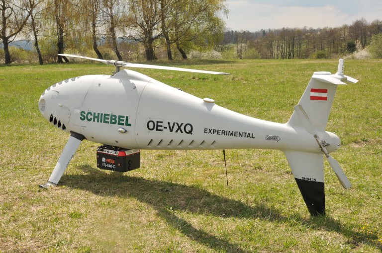
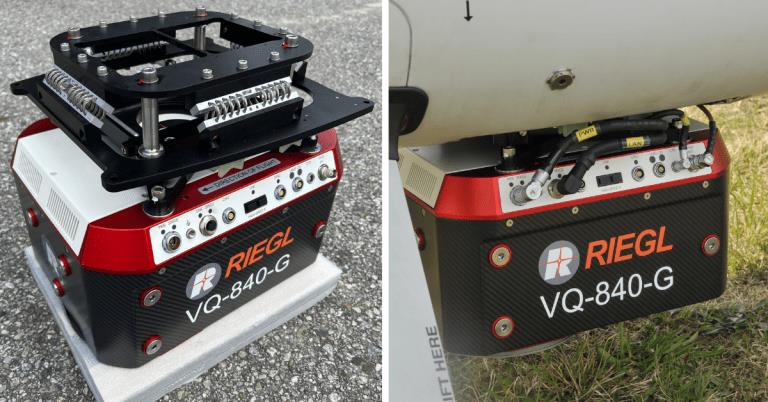
RIEGL Laser Measurement Systems GmbH and Schiebel have successfully completed the integration of a laser scanning system, the RIEGL VQ-840-G topo-bathymetric lidar sensor, on the Schiebel CAMCOPTER S-100 UAS. The RIEGL VQ-840-G, combined with the technical specifications and performance of the CAMCOPTER S-100 UAS, enables an efficient and secure way for surveying shallow waters, where monitoring from boats becomes a challenge.
The applications of airborne lidar bathymetry include the mapping of coastlines and riverbanks, as well as the monitoring of natural habitats, water reservoirs and hydraulic engineering applications.
In a single data acquisition mission, data below and above the water surface are covered.
Image: RIEGL
Additionally, the topographic laser scanners RIEGL VUX-1UAV/-LR and VUX-12023 can be integrated in the front payload bay of the CAMCOPTER S-100.
The VQ-840-G topo-bathymetric laser scanner is designed for use in a variety of maritime and hydrographic environments. The lidar sensor payload system is controlled remotely via a data link, which was crucial for the integration into the S-100 system.
The scanner is controlled by using the onboard software RiACQUIRE-Embedded via the available data link; data acquisition and laser safety are also monitored. Once the survey is completed, the raw data seamlessly integrates into the RIEGL data processing workflow.