Tag: BDS

  • Directions 2019: BeiDou accelerates global deployment

    Directions 2019: BeiDou accelerates global deployment

    Yang Changfeng, chief architect of China's BeiDou navigation satellite system. (Photo: BeiDou)
    Yang Changfeng, chief architect of China’s BeiDou navigation satellite system. (Photo: BeiDou)

    By Yang Changfeng
    Chief Architect, BeiDou Navigation Satellite System

    As one of the core GNSS, the BeiDou Navigation Satellite System (BDS) has been developed following a three-step development strategy. By around 2020, BDS will form a space constellation consisting of 30 satellites, including three satellites in geostationary earth orbit (GEO), three satellites in inclined geosynchronous satellite orbits (IGSO), and 24 satellites in medium earth orbits (MEO). It will provide free open and high-quality services, including navigation, positioning, timing, short message communication, search and rescue, and so on to the users worldwide.

    In 2018, BDS has made fruitful results in the aspects of system construction, integrated applications, and international development.

    System Construction

    The stable operation of the BDS-2 constellation and construction of the BDS-3 constellation have resulted in solid achievements, while the deployment of the ground-based and satellite-based augmentation systems has made remarkable progress, and the International Multi-GNSS Monitoring and Assessment System (iGMAS) has been in stable and continuous operation

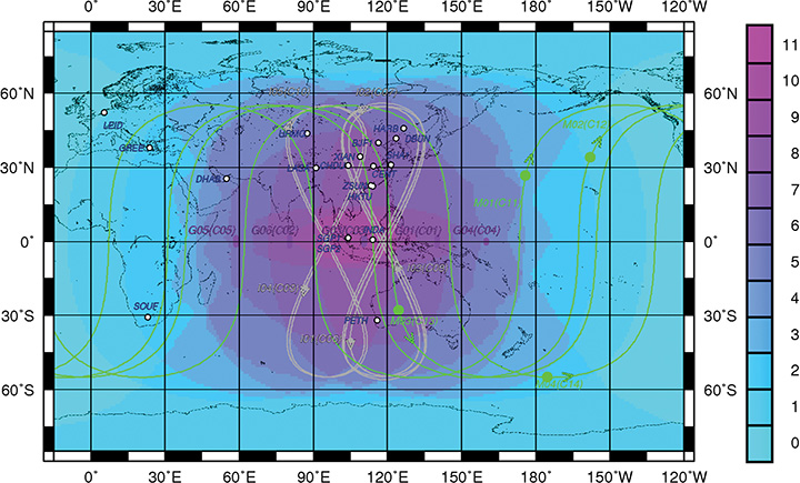
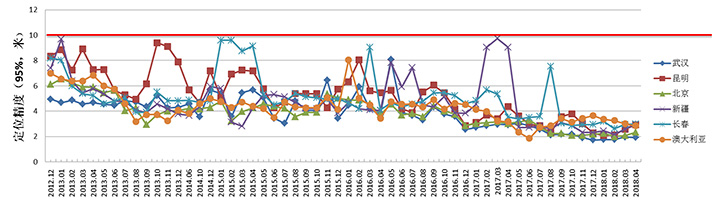
    BDS-2 Improved Regional Services. Through upgrades and enhancements of the ground system, the service performance, stability and availability of the BDS-2 constellation has been improved. The analysis results shows that the nominal positioning accuracy of BDS-2 in its coverage area is better than 5 meters. To achieve user-oriented services, the Interface Control Document (ICD) for the open service signal B3I has been released.

    The basic system of iGMAS has been completed, consisting of 24 ground stations and various centers, to provide raw data, basic products, and monitoring and assessment information services to users through the Internet and smartphones.

    BDS-2 Positioning Performance. (Chart: BeiDou)
    BDS-2 Positioning Performance. (Chart: BeiDou)

    BDS-3 Constellation Deployment. By late 2018, 16 MEO BDS-3 satellites and 1 BDS-3 GEO satellite were in orbit. China successfully launched the 18th and 19th BDS satellites on Nov. 19. Deployment of the basic BDS-3 constellation has been accomplished.

    The BDS-3 satellites are equipped with the higher-performance rubidium atomic clocks with stability of E-14 as well as hydrogen atomic clocks with stability of E-15. The signal-in-space (SIS) accuracy will be superior to 0.5m, the position accuracy will reach 2.5 to 5 meters, and the overall performance will be dramatically improved. The in-orbit test results have indicated that the BDS-3 satellites are in sound condition, and the performances can satisfy nominal parameters. For the convenience of public applications, the ICDs of the new signals, B1C and B2a, have been released.

    BDS-3 will inherit the short message communication service from its predecessors, and will further enhance the basic PNT service capabilities. Satellite-Based Augmentation System (SBAS) and Search and Rescue (SAR) services will be developed according to the international standards.

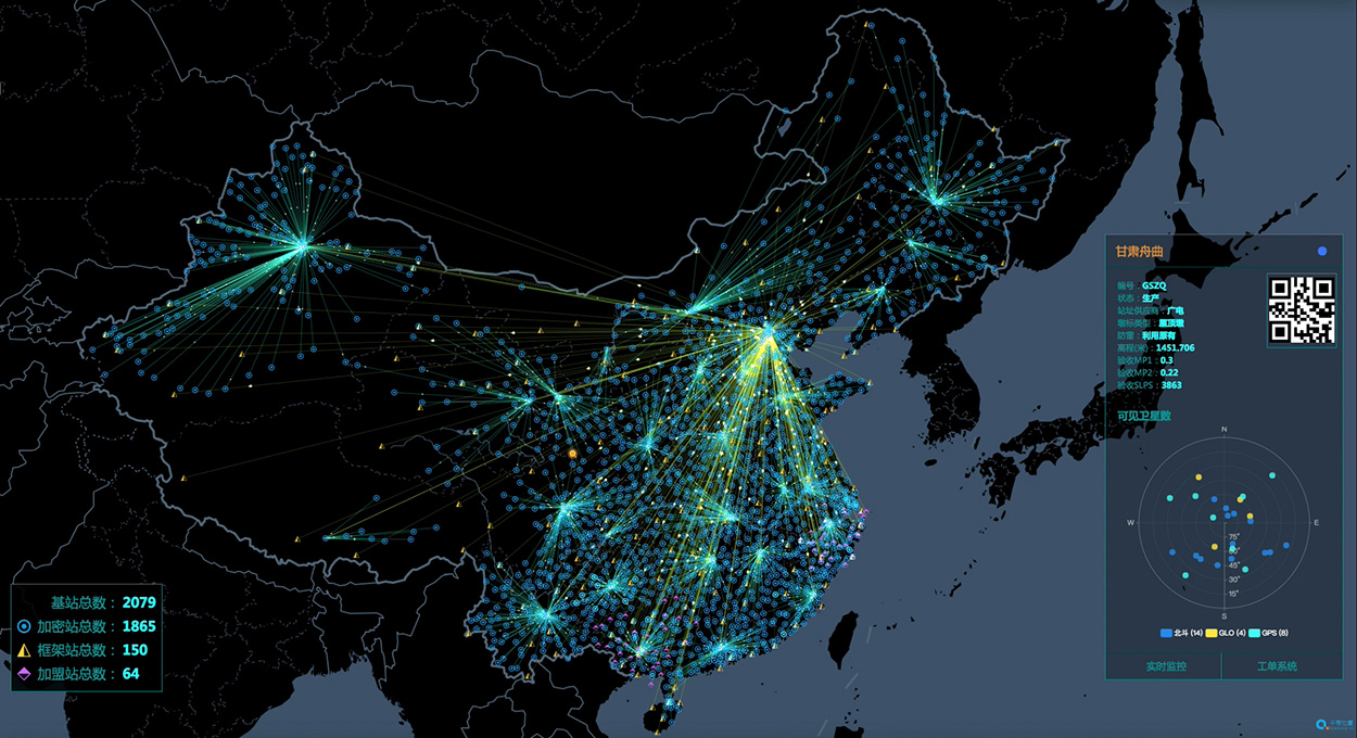
    Ground-Based Augmentation. The BDS/GNSS Ground-based Augmentation System has completed the deployment of 155 framework reference stations and nearly 2,400 regional stations in China. The system has carried out high-precision applications in many fields, such as surveying, national resources, disaster mitigation, transportation, meteorology, and offered basic services for users, including real-time navigation services at meter-level and decimeter-level, as well as precise positioning services at centimeter-level and millimeter-level.

    China's National Reference Station Network. (Image: BeiDou)
    China’s National Reference Station Network. (Image: BeiDou)

    First SBAS GEO Satellite. The BeiDou Satellite-based Augmentation System (BDSBAS) is being developed in accordance with the International Civil Aviation Organization (ICAO) standards, to offer navigation services with superior accuracy and integrity.

    In November 2018, the first GEO satellite with SBAS and SAR payloads has been successfully launched. The short message communication service offered by the satellite will be fully compatible with that of BDS-2, while the service volume will be increased by 10 times and the user’s transmit power will be reduced to 1/10. As the result, the user terminals will possess smaller size, higher integration and enhanced capacity.

    Integrated Applications

    As the system construction accelerates, BDS is also making great efforts to strengthen the development of fundamental products and applications in various fields. The integrated applications adopt the “BDS+” model, to stimulate the growth of satellite navigation industry.

    Fundamental Products. At present, the fundamental BDS products have been used in mass market applications, of which the performance has reached or close-to the world-class level. By the 3rd quarter of 2018, the sales volume of BDS navigation chips and modules exceeded 70 million pieces, and the amount of the BDS-enabled terminals surpassed 500 million pieces or sets. In 2017, the domestic output value is more than RMB 250 billion (US $ 36 billion), in which the BDS contribution exceeds 80%.

    Industrial Applications. BDS continues to facilitate the integrated applications and development of related industries; to bring GNSS high-precision services in combination with cloud computing, internet of things, big data and other technologies; to push forward the fusion among BDS-related industries and high-end manufacturing, software, integrated data industries, and to enable BDS-based applications to solve the problems associated with national economy and people’s livelihood. BDS has been integrated into various national significant infrastructures, by providing time and space references for transportation, meteorology, agriculture, electricity, communications, finance and other industries.

    Meanwhile, “BDS+” and “Time and Space+” applications targeted towards the mass market are enjoying a broader future prospect. The BDS-based navigation services have been adopted by various enterprises in the fields of smart mobile terminal manufacture, location-based services (LBS), e-commerce, and so on. The BDS-based LBS have been widely use in the public consumption sector and people’s livelihood, which have been changing people’s life by providing more conveniences for the public.

    BDS International Development. BDS continuously pushes forward international development, carries out practical cooperation and exchanges, and promotes the development of GNSS community, to better serve the world and benefit mankind.

    BDS actively participates in related activities under the framework of the United Nations, other international organizations and multilateral platforms. In June, 2018, BDS took part in the UNISPACE+50 Exhibition and donated a BDS-3 satellite model to the United Nations Office for Outer Space Affairs.

    In November 2018, the 13th Meeting of the International Committee on Global Navigation Satellite Systems (ICG-13) was successfully held in Xi’an, China. His Excellency Xi Jinping, President of the People’s Republic of China, sent a congratulatory letter to the ICG-13, and expressed that “China is willing to work with all countries, to share the construction and development achievements of BDS, and to jointly promote the development of global satellite navigation.” More than 400 representatives from 16 nations and 16 regional and international organizations attended the meeting and made in-depth exchanges on over 20 topics related to satellite navigation.

    BDS has always been exploring joint applications with other compatible navigation satellite systems, and carrying out bilateral coordination and cooperation.

    In November 2017, the Joint Statement of BDS and GPS Signal Compatibility and Interoperability was signed, which stated that the two systems were radio-frequency compatible within the framework of ITU, and BDS B1C civil signal and GPS L1C civil signal had achieved interoperability.

    In November 2018, the Agreement between the Government of the People’s Republic of China and the Russian Federation on Cooperation in the Field of the Use of BDS and GLONASS for Peaceful Purposes was signed, which would facilitate the complementarity and integrated development, promote practical cooperation projects, and contribute to more efficient and reliable services for global users.

    At present, BDS has covered more than 50 countries and over the population of 3 billion people. The BDS-related products have accessed to the markets of over 80 countries and regions. In April, 2018, the first overseas BDS/GNSS Center was opened by China Satellite Navigation Office and the Arab Information and Communication Technology Organization, to enrich the public awareness, experience and applications of BDS in Arab nations.

    The international GNSS Monitoring and Assessment System (iGMAS) has contributed to the implementation of the Asia-Pacific Space Cooperation Organization project, iGMA-International GNSS Service Pilot experimental project, and Sino-Russian monitoring and assessment cooperation, and has provided GNSS users with authentic third-party assessment results.

    Future Plans

    BDS will continuously promote joint applications of multiple navigation satellite systems, and provide global users with diversified choices for better application experiences. BDS welcomes users and equipment providers worldwide to participate in the Global Users’ Experience and Evaluation Campaign (relevant information can be referred to the BDS official website), and will release the experience and evaluation results when appropriate.

    By the end of 2018, BDS-3 will possess the initial operational capability and implement all-round validation on its global service performance. Between 2019 and 2020, BDS will keep improving its continuous stability and service accuracy, maintain the BDS-2 service performance stable and enhanced, and continue the BDS-3 deployment by launching another 6 MEO satellites, 3 IGSO satellites, and 2 GEO satellites, to eventually possess global service capabilities by 2020.

  • China to launch 11 more BeiDou-3 satellites this year

    China will launch 11 more BeiDou-3 satellites by the end of 2018, according to the Xinhua News Agency, the official state-run press agency.

    China has already launched eight BeiDou-3 satellites for its domestic BeiDou Navigation Satellite System. The satellites will provide initial services for countries and regions along the Belt and Road by the end of the year, said Wang Li, chairman of the China Satellite Navigation System Committee.

    Addressing the Ninth China Satellite Navigation Conference in Harbin, capital of northeast China’s Heilongjiang Province, Wang said the BeiDou system is moving to become a global service provider after offering stable and reliable time and space information for clients in the Asia-Pacific region.

    China launched the first two BeiDou-3 satellites into space via a single carrier rocket in November 2017, as its self-developed BeiDou system officially began to expand into a global network.

    Compared to earlier generation satellites, the BeiDou-3 is able to send signals that are more compatible with other satellite navigation systems and provide satellite-based augmentation, as well as search-and-rescue services in accordance with international standards. Its positioning accuracy has reached 2.5 to 5 meters.

  • BeiDou inaugurates first overseas center in Tunisia

    BeiDou inaugurates first overseas center in Tunisia

    The first overseas center for China’s BeiDou Navigation Satellite System (BDS) was inaugurated in Tunis, Tunisia, on April 10, according to the Xinhua News Agency.

    The China-Arab States BDS/GNSS Center was established as a pilot project between China and the Tunisia-based Arab Information and Communication Technology Organization (AICTO), an Arab governmental organization under the Arab League, to promote the global application of BeiDou, said Ran Chengqi, director of the China Satellite Navigation Office.

    “The center could serve as both a window to showcase the BDS, and a platform for promoting international exchanges and cooperation,” Ran said.

    Mohamed Ben Amor, secretary general of AICTO, hailed the center as a unique technology project for the Arab region and the entire world. AICTO will “intensify its cooperation with China in the field of satellite navigation to boost technological advance and economic development in the region,” Amor said.

    The BeiDou pilot project will help train satellite navigation scientists and develop digital economy in Arab countries, according to Khalil Amiri, Tunisia’s secretary of state for scientific research. “We are working closely with China to effectively access and develop win-win database services via BeiDou and other satellites for various uses,” Amiri said.

    Ran (left front) and Amor shake hands during the inauguration ceremony of the China-Arab States BDS/GNSS Center in Tunis. (Photo: Xinhua)
  • Directions 2018: BeiDou builds, diversifies, expands

    Directions 2018: BeiDou builds, diversifies, expands

    By Changfeng Yang,
    Chief Architect of BeiDou Navigation Satellite System

    Changfeng Yang

    As one of the four major GNSS providers, the establishment of BeiDou Navigation Satellite System (BDS) has been steadily developed, following a three-step strategy. By around 2020, BDS will form a nominal space constellation consisting of 30 satellites, including three satellites in geostationary Earth orbit (GEO), three satellites in inclined geosynchronous satellite orbit (IGSO) and 24 satellites in medium Earth orbit (MEO). It will provide global users with open and high-quality services free of charge, including navigation, positioning, timing, short message communication, search and rescue and so on.

    BDS is aimed at developing into a world-class global navigation satellite system, with innovative and advanced technologies, extraordinary user experience, international development and worldwide presence, which can provide fundamental time and space reference for national defense and economic-social development, and advance the progress of high-tech and IT industries.

    BDS has initiated several innovative attempts in the fields of both international satellite navigation and domestic aerospace for the first time, and paved a unique development path of a satellite navigation system, with an eye on the state conditions and distinctive features. On Jan. 9, 2017, the BD-2 Project won the top National Scientific and Technological Progress Award. In 2017, BDS achieved fruitful results in the aspects of system construction, integrated applications and international development.

    System Construction

    Through upgrading and reconstructing the ground system, the service performance, stability and availability of the BD-2 constellation have been improved. To achieve user-oriented services, the updated Interface Control Document (ICD) for B1C and B2a open service signals (Version 2.1) was released in accordance with the constellation change.

    The international GNSS Monitoring and Assessment System (iGMAS) has been built, consisting of eight domestic monitoring stations and 16 overseas stations, to monitor and assess the service performances of BDS, GPS, GLONASS and Galileo at real-time worldwide. It has taken all factors into consideration, including constellation status, signal-in-space, navigation message, service performance and high-precision products, and so on. According to its analysis results, the nominal positioning accuracy of the BD-2 system in the coverage area has been optimized from 10 meters to 8 meters.

    Development of the BD-3 System. On Nov. 5, the first pair of the 24 BD-3 MEO satellites were successfully launched, while another pair is planned to be launched by the end of the year.

    Liftoff of the first pair of the BD-3 MEO satellites on Nov. 5, 2017. (Credit: Xinhua)

    The BD-3 satellites are equipped with B1C and B2a signals with optimized performance, which are compatible and interoperable with other GNSS signals. The interface control document of B1C and B2a signals (beta version) was released in September. The BD-3 satellites also adopt the higher-performance rubidium atomic clock with stability of E-14 and hydrogen atomic clock with stability of E-15. By utilizing new technologies, the signal-in-space (SIS) accuracy will be superior to 0.5 m; the position accuracy will be doubled or quadrupled, and reach 2.5 m to 5 m.

    The BD-3 system will retain the short message communication service of its predecessors, and further enhance basic positioning, navigation and timing (PNT) service capabilities. Satellite-based augmentation system (SBAS) and search-and-rescue (SAR) services will be added and developed according to international standards.

    After in-orbit tests and networking validation, the BD-3 satellites will be able to provide operational services, and accelerate the global coverage of BDS.

    Ground-Based Augmentation. The Phase I construction of the BDS/GNSS ground-based augmentation system has been completed, consisting of 150 framework reference stations, 1,200 reference stations of higher density network, national data processing center, six industrial data-processing centers, and manufacturing of user terminals. This system has achieved basic service capabilities, and its service performance standard (version 1.0) has been released. Through integration with the internet, a cloud platform has been established to provide high-precision space-time information services, including real-time navigation services at meter-level and decimeter-level, as well as precise positioning services at centimeter-level and millimeter-level.

    Satellite-Based Augmentation. Based on the International Civil Aviation Organization (ICAO) standards, system demonstration and validation work on the BeiDou Satellite-Based Augmentation System (BDSBAS) has been completed, and the technical status of the system has been confirmed in accordance of the next-generation SBAS Dual Frequency Multiple Constellation (DFMC) standards.

    Integrated Applications

    Currently, a great number of independent, self-controlled intellectual property rights on the fundamental BDS products have been achieved. World-class, advanced technologies have been developed. With the release of the first Chinese in-house developed meter-level fast positioning BDS chip, BDS applications have begun to embrace the era of meter-level positioning.

    In 2017, the sales volume of BDS navigation chips and modules exceeded 50 million pieces, and that of high-precision surveying boards and navigation antenna captured 30% and 90% of market shares respectively. There are more than 14,000 enterprises (including more than 50 publicly listed companies), and more than 450,000 employees in China engaging in BDS-related business.

    The annual output value of the publicly listed company in 2017 is more than RMB 50 billion (US $7.53 billion). The number of terminals produced by domestic enterprises surpasses 40 million pieces/sets. BDS has gained recognition from mainstream chip producers such as Qualcomm, Trimble, Hemisphere GNSS, Huawei, Samsung, u-blox, MTK, Broadcom, NovAtel and more, and the total number of terminals is estimated to surpass 300 million pieces or sets.

    BDS continues to:

    • promote integrated applications and development of related industries;
    • bring GNSS high-precision services in combination with cloud computing, Internet of Things, big data and other technologies;
    • push forward the integration between BDS-related industries and high-end manufacturing, software, and integrated data industries.

    BDS has been applied in the transportation, logistics, emergency rescue, marine fishing and other fields, which has greatly improved production efficiency, reduced resource consumption, and lowered pollution. For example, benefiting from the BDS applications in traffic management industry, the number of major accidents has decreased by 46.7%, and the death toll has been reduced by 48.9%. With BDS-based maritime applications, more than 10,000 lives have been saved.

    BDS/GNSS augmentation services have been applied to precision agriculture, land mapping, monitoring on deformation and displacement of large-scale public facilities, and earthquake and geological hazard measurement and survey; the latter has provided important monitoring for public safety. As a result, the production of precision agriculture has increased by 5%, and the oil consumption by agricultural machinery has decreased by 10%. The time for surveying and mapping of national land is shortened from a few days to several seconds.

    BDS has been fully put into mass applications. BDS-based navigation services have been adopted by various enterprises, such as Huawei, ZTE, Baidu, Autonavi, Alibaba, JD and others in the fields of manufacturing of mobile and smart terminals, location-based services (LBS), e-commerce, and so on. BDS-based LBS have been widely applied in the mass consumption sector and people’s livelihood, and many innovative applications have emerged, such as caring for seniors and children, shared vehicles, BDS-based logistics, and so on, which have been changing people’s lives and providing more convenience for the public.

    International Development

    At present, BDS has covered more than 50 countries and more than 3 billion people. BDS-related products have gained access to the markets of more than 70 countries and regions, more than 30 of which are along the (land-based) Belt and (maritime) Road (in line with the Belt and Road Initiative). Through joint applications with other compatible navigation satellite systems, BDS provides global users with diversified choices for better application experience.

    Meanwhile, the iGMAS has contributed to the implementation of the Asia-Pacific Space Cooperation Organization project, iGMAS-International GNSS Service Pilot experimental project, and Sino-Russian monitoring and assessment cooperation, and has provided GNSS users with authentic third-party assessment results. China continuously pushes forward BDS to be recognized by the ICAO, International Maritime Organization (IMO), mobile communication standard Partnership Project and other organizations, to serve the world in line with international conventions.

    In October, three PRN codes which are essential to the development of BDSBAS were assigned; the SBAS service provider identifier and UTC standard identifier have been assigned to BDSBAS by ICAO, which marks BDSBAS an official SBAS provider in the ICAO family, and lays the foundation for the follow-up construction of BDSBAS, as well as its provision of standard navigation services for the civil aviation sector.

    In March, a multi-system (including GPS, BDS and GLONASS) ship-borne receiver standard was approved by the IMO. BDS has also been included in the PNT guidelines of maritime applications.

    In the field of mobile communication, 26 technical standards that support the BDS positioning function have been adopted by the third- and fourth-generation mobile communication standard Partnership Projects.

    Future Plans

    BDS will keep improving its continuous stability and service accuracy. Two more BD-2 replacement satellites will be launched in 2018, ensuring its regional service performance will be remain stable and be enhanced.

    Eighteen BD-3 MEO satellites and one BD-3 GEO satellite will be launched by around the end of 2018. Upon the deployment of those 19 satellites, BD-3 will possess the initial operational capability and serve the countries along the Belt and Road. The official version of ICD for B1C and B2a open service signals, as well as other system documents, will be released, in line with the operational status of BD-3 satellites, for the convenience of public applications.

    In regard to augmentation systems, China plans to complete the construction of Phase II BDS/GNSS ground-based augmentation system in 2018, and advance the recognition of BDS-based high-precision services as public goods. In 2018, the first BDSBAS GEO satellite with the BDSBAS payload will be launched to start the deployment of the BDSBAS system.

    In terms of applications and international development, China will give full play to the role of BDS in the integration procedure between industrialization and IT applications, to promote the development of information industry, adjustment and upgrading of industrial structure.

    China will also strengthen the cooperation and communication with other navigation satellite system providers, carry out coordination under the framework of international organizations and multilateral platforms, improve the international development of BDS, provide better services for users along the Belt and Road, and expand BDS services to serve users worldwide.

  • US, China cooperate on interoperability for better civilian service

    The United States and China have negotiated compatible signal characteristics that will both protect and enhance service for users of the U.S. GPS and Chinese BeiDou constellations.

    The achievement resulted from several years of discussions between U.S. and Chinese GNSS experts. The consensus to make the systems compatible and interoperable at the user level will mean better service for users of both systems worldwide.

    The U.S.Department of State’s Bureau of Oceans and International Environmental and Scientific Affairs Office of Space and Advanced Technology represents the United States in the ongoing U.S.-China GNSS Cooperation Dialogue, which began in May 2014 and covers various topics.

    Compatibility of the Chinese BeiDou Navigation Satellite System (BDS) with GPS has been a core focus of the discussions. The U.S.-China Joint Statement on signal compatibility and interoperability is below and on the gps.gov website.


    Joint Statement on Civil Signal Compatibility and Interoperability Between the Global Positioning System (GPS) and the BeiDou Navigation Satellite System (BDS)

    December 4, 2017

    In May 2014, China Satellite Navigation Office and the Office of Space and Advanced Technology, U.S. Department of State, jointly established the U.S.-China Civil GNSS Cooperation Dialogue, a bilateral government-to-government mechanism to promote cooperation between the U.S. Global Positioning System (GPS) and the Chinese BeiDou Navigation Satellite System (BDS).

    Over the past three years, representatives and experts from both sides have studied and discussed various topics related to civil service provision and user applications, among which BDS compatibility and civil interoperability with GPS is one of the core focus areas.

    Both sides have carried out extensive in-depth analysis, and have engaged in persistent discussion and coordination.

    As a result, the two sides have reached the following consensus conclusions regarding compatibility and interoperability between GPS and BDS:

    1. Consistent with the bilateral frequency compatibility coordination completed in 2010, GPS and BDS are radio frequency compatible under the framework of the International Telecommunication Union (ITU); and
    2. The GPS L1C and BDS B1C civil signals, using two different types of multiplexed binary offset carrier (MBOC) waveforms are interoperable, which means users can receive better service by jointly using these civil signals without a significant increase in receiver cost or complexity.

    Both sides agree to continue their consultations and cooperation related to compatibility and interoperability in order to provide better services for global users.

    (signed by)

    Ran Chengqi, China Satellite Navigation Office

    David A. Turner, Office of Space and Advanced Technology, U.S. Department of State


    For more information, contact [email protected]. Follow the Bureau of Oceans and International Environmental and Scientific Affairs on Twitter at @StateDeptOES.

  • Directions 2017: BeiDou’s road to global service

    Directions 2017: BeiDou’s road to global service

    An effective approach has been taken by the BeiDou Navigation Satellite System (BDS), and significant progress has been witnessed in 2016, from the aspects of launching new satellites, verifying new technologies, promoting applications and industrialization, strengthening international cooperation, and formulating fundamental policies.

    Li Wang
    Li Wang

    Construction Update. In March 2016, a BDS satellite was launched into an inclined geo-synchronous orbit (IGSO); another geosynchronous orbit (GEO) satellite was launched in June. These became the 22nd and 23rd BDS satellites overall and further enhanced service capability. The BDS has been maintaining stable operation, and the performance of BDS Open Services has steadily improved. The availability and continuity surpass 99.9%, which can satisfy the nominal requirements of 95% and 99.5%.

    The deployment of a BDS global constellation has progressed steadily. Five new-generation BDS satellites have been successfully launched so far, to verify advanced signal structure, crosslink, on-board clocks with higher accuracy, and other new technologies. Test results showed that the inter-system technical status is coordinated, the accuracy of orbit prediction was increased by 50%, and accuracy of time maintenance was upgraded by about 60% due to crosslink.

    Meanwhile, the construction of augmentation systems is being accelerated. A nationwide reference station network has been built, and the construction of the basic system has been completed. System performance is under test, including meter and decimeter level for wide-area real-time services, centimeter level for areas within Beijing, and millimeter level for post-processing services.

    As for satellite-based augmentation system (SBAS), BDS is actively participating in the design and international coordination activities for the next generation dual-frequency multiple-constellation (DFMC) SBAS standards. The 30th SBAS Interoperability Working Group (IWG) meeting was successfully held in China.

    The document “Development of BDS and Applications of Multi-Frequency Multi-Constellation Navigation Satellite Systems” was submitted by the Civil Aviation Administration of China (CAAC) during the 39th meeting of International Civil Aviation Organization. This represents Chinese civil aviation authority’s official support of construction of BDSBAS. Development of applications of multi-frequency multi-constellation has been proposed to the international civil aviation community.

    BDS Applications. With the enhancement of BDS service capability, its applications are also making remarkable progress, already producing a BDS industrial chain which comprises the basic products, application terminals, application systems and operational services.

    BDS-based chips have been upgraded in quality and quantity. Great efforts are being made to carry out demonstrations of BDS industrial and regional applications. Mass market applications are flourishing. Chinese industrial production in the field of satellite navigation reached 190 billion renminbi yuan (US$28 billion) in 2015, of which BDS would contribute about 30%. So far, BDS-related products have already been exported to more than 70 countries, and applications and services are available in over 30 countries along the Silk Road Economic Belt and 21st-Century Maritime Silk Road (the Belt and Road) region.

    International Cooperation Activities. BDS continuously carries out bilateral and multilateral exchanges and cooperation, in line with the principle that “BDS is developed by China, and dedicated to the world.”

    To provide better services for global users, BDS carries out exchanges and coordination with the other navigation satellite systems in terms of compatibility and interoperability, monitoring and assessment, frequency resource, augmentation systems and other areas. It also strives to implement applications cooperation with countries in the Asia-Pacific region, members in the Association of South-East Asian Nations (ASEAN) and the League of Arab States (LAS), to bring more benefits to a wider range. On multilateral platforms, BDS continuously contributes to efforts and meetings of the International Committee on Global Navigation Satellite Systems (ICG) and the Committee on the Peaceful Uses of Outer Space (COPUOS). In addition to these international academic activities, China has also been organizing the China Satellite Navigation Conference for seven sessions.

    Fundamental Policies. A whitepaper on BDS released in June 2016 interprets its development concepts and propositions, and is available on the official BDS website. The major content includes: to provide open services for global users free of charge; to continuously improve service performance and enhance the service quality; to promote compatible applications with other navigation satellite systems and to improve users’ benefits; to disseminate BDS information in a timely manner; to protect the radio-navigation satellite frequency spectrum according to law and to firmly reject harmful interference; to enhance BDS applications, industrial development and international application; to actively carry out international cooperation and exchanges, to participate in multilateral activities in the field of international satellite navigation and to promote the ratification of the BDS by international standards.

    The “BeiDou Navigation Satellite System Signal In Space Interface Control Document” (Version 2.1) was published in November.

    As for the standardization process, the “BeiDou Satellite Navigation Standard System” (Version 1.0) has been released, and BDS has been included in the Receiver Independent Exchange Format (RINEX, Version 3.03), approved by the Radio Technical Commission for Maritime Services Special Committee 104 on GNSS Service, RTCM SC-104.

    Follow-up Deployment Plans. In 2017, three to four launches of BeiDou satellites will occur. BDS will provide basic services to the countries along the Belt and Road region by 2018, and possess global service capability by 2020.

    BDS will keep improving its nationwide reference station network and steadily enhance its service performance. The dense reference stations for the nationwide frame network will be constructed by 2018, providing meter and decimeter level real-time location services for users in China, even centimeter level service in some areas.

    BDS will carry out the design, validation and construction of SBAS in accordance with international civil aviation standards. The first GEO satellite of BDSBAS will be launched in around 2018. The satellite-based augmentation services covering China and surrounding regions will be provided from 2020, to provide CAT-I services to civil aviation users.

    China will promote construction of a national comprehensive positioning, navigation and timing (PNT) system based on BDS, and strive to establish such a national PNT system with a united benchmark, no-gap coverage, security and effectiveness by 2030, as well as to upgrade capabilities to provide time and space information.

    Summary. BDS will boost the deployment of a global constellation, continuously enhance performance, fulfill its service commitments, make all efforts to advance satellite navigation applications, promote the development of GNSS, and better serve the world and benefit mankind.

  • Directions 2016: A new stage for the development of BeiDou

    Directions 2016: A new stage for the development of BeiDou

    Shuren Guo, deputy director of China Satellite Navigation Project Center.
    Shuren Guo, deputy director of China Satellite Navigation Project Center.

    By Shuren Guo

    In line with its three-step development plan, the BeiDou Navigation Satellite System (BDS) will constitute a complete space constellation by around 2020, when it will be comprised of five geosynchronous orbit (GEO) satellites and 30 non-GEO satellites, providing services for global users. The year 2015 is of particular significance for the BDS establishment, which has witnessed stable operation of regional services and formal deployment of new-generation satellites. These satellites possess higher performance and better compatibility and interoperability with other navigation satellite systems.

    In March 2015, the first new-generation BDS satellite, or 17th BDS satellite overall, was launched at the Xichang Satellite Launch Center, and kicked off the deployment of the BDS global constellation. Launched and directly inserted into an inclined geo-synchronous orbit (IGSO) by a Long March launch vehicle with a newly designed upper stage, the satellite is equipped with a new bus system, as well as a payload system carrying inter-satellite links and new navigation signals.

    In July 2015, two mid-Earth orbit (MEO) BDS satellites, the 18th and 19th overall, were launched into their scheduled orbits precisely with one single launch vehicle. More new types of payloads are on board, and the satellite performance is dramatically improved. After the in-orbit-delivery, these two satellites are able to interconnect with other existing BDS satellites, and jointly carry out the experiment and verification of the global network deployment process.

    In September 2015, another BDS satellite was successfully launched into IGSO, and became the 20th of the BDS space constellation. Different from pervious launches, this satellite reached its designed orbit by using its built-in autonomous orbit maneuver mechanism. For the first time, the satellite also carries a Chinese-made hydrogen atomic clock, which provides enhanced time and frequency reference capacities.

    Currently, these last four launched satellites are in normal working mode. The ongoing in-orbit tests show that these satellites satisfy the desired requirements. At present, tests and validations for the new navigation signal system, inter-satellite links, and the new atomic clock are being conducted. Once the tests and validations are completed, these satellites will be included in the network, and start to provide services for global users.

    In 2016, BDS will keep improving its service performance. Three BDS satellites will be launched to boost up the deployment of global constellation. The construction of the BDS augmentation systems will be accelerated. Meanwhile, international cooperation activities will be further promoted, and the application development process will be attached with much importance, to broaden the fields and domains of BDS/GNSS applications.

    “To serve the world and benefit Mankind” is not only the purpose of BDS, but also its commitment to the world. On the basis of maintaining stable services, BDS will make all efforts to enhance the performance, to speed up the deployment of global constellation, and to provide better services for global users.


    Shuren Guo is the deputy director of China Satellite Navigation Project Center. He received his bachelor’s degree in electromagnetic theory and microwave engineering from Xi’an Jiaotong University, and his master’s in electronics and communication engineering from Beihang University. As a researcher, he has long been engaged in the design, research and development of the BeiDou Navigation Satellite System.

  • Expert Advice: Tigers, Tycoons on View at China SatNav

    Expert Advice: Tigers, Tycoons on View at China SatNav


    CSNC-2

    Turetsky-calloutI attended the China Satellite Navigation Conference in Nanjing in May, the fifth year of CSNC and my third time attending. Tremendous progress was evident this year in terms of BeiDou (BDS) deployment and China’s general openness and willingness to collaborate over those years. I have also seen a slowly growing international presence at the show and expect that to continue to increase as well. You may recall my column last year about Little Tigers. Well, they aren’t so little any more. As for the tycoons, you will have to read to the end.

    The conference opened with the usual provider updates. Chenqi Ran, who runs the China Satellite Navigation Office, the lead government agency for BDS, started off. It’s always good to hear his update delivered in China, where the is a little more freedom to provide information beyond the standard pitch. China continues on pace to its plan for the third step of BDS with five geosynchronous-orbit, three inclined geosynchronous-orbit, and 27 mid-Earth orbit satellites for a worldwide system by 2020. They are meeting their stated goal of 10-meter accuracy regionally today, and as good as 5-meter near the Equator. Ran also provided interesting numbers for the fast-growing Chinese domestic market:

    • More than 2 million BDS chips sold in China in Q1
    • More than 300,000 vehicles equipped with BDS
    • 20 domestic brands offering car navigation systems
    • First consumer tablet (Samsung Galaxy Note 3) with BDS.
    • First consumer smartphone (Huawei B199) with BDS

    The updates from other providers (GPS, GLONASS, and Galileo) were relatively standard and did not contain much new information. I had hoped that maybe the Russian presentation would provide more information about the April outages, but nothing was forthcoming and I was not overly surprised.

    CSNC-4The conference itself is very well organized and runs nine parallel technical tracks over two full days, with additional special-interest sessions. All of the presentations are in Chinese, however the conference provides headsets for simultaneous translation, and many presenters have dual slide sets in Chinese and English, so it is easy to attend anything that seems interesting.

    I came as an invited speaker on the Institute of Navigation (ION) panel organized by Professor Jade Morton from Miami University, Ohio, and Professor Lu of the National Timing Service Center near Xian. The ION panel was well attended and included a short panel discussion at the end.

    One of the most interesting outcomes was that both Broadcom and Trimble showed approximately 25 percent accuracy improvement by adding Beidou to their existing GPS/GLONASS solutions. It was interesting not just because they reached the same number, but because Broadcomm was talking in meters about urban-canyon performance and Trimble was talking in centimeters about precise positioning.

    It became clear that everyone sees BDS as an important part of their roadmap at L1, regardless of how many frequencies they currently support. I must also note that both Professor Morton and Professor Lu were outstanding hosts and showed us some of the wonderful local sites.

    Exhibit Hall

    The biggest change from last year was in the exhibit hall. I would estimate the overall floor space grew by 50 percent, with 106 companies in specially designed booths (up from 56 last year) and another 44 in standard booths.

    The content change was even more dramatic. Last year there were a lot of small booths with pretty basic displays, mostly of prototypes and slideshows. This year, there were many more extremely large booths that were very professionally created. They had evolved into displaying very polished-looking finished products with nicely edited videos. It was clear that this was all targeted at domestic buyers, as it was difficult to find anyone on the show floor who spoke English (except in the Spirent booth). These are no longer little tigers. These are now real companies, out hunting for new business.

    CSNC-3

    Policy and Intellectual Property

    My other favorite topic to listen to at this conference is on policy and intellectual property (IP). That is where I spent most of my time and was not disappointed. There was in fact an entire session dedicated to intellectual property, and several presentations on the global state of affairs of patents in GNSS.

    Interestingly, most of the speakers were either lawyers or from government, but there were some corporate ones as well. Several speakers highlighted the recent disagreement and settlement of the patent dispute between the United States and the United Kingdom over complex modulation patents. There was a large element of underlying concern that although the U.S. had been able to settle the dispute, it might be very hard for China if either the U.S. or the UK came after them. They had several charts showing how far behind they were in GNSS patents, in an effort to encourage local companies to create more IP and patent it. They also showed they have made significant progress in recent years in domestic Chinese patents, though they still have a long way to go in international patents.

    They were also very concerned about the largest holders of GNSS patents in China — Qualcomm and Broadcom — as a threat to domestic industry. They cited the GlobalLocate/Broadcom versus SiRF/CSR lawsuit as a cautionary tale. Several presenters showed the dominance of Broadcomm and Qualcomm in terms of domestic Chinese patent holdings and referred to them as the “Tycoons.” I envisioned Rich Uncle Moneybags, the guy from the Monopoly game wearing the top hat, walking around with patents instead of dollar bills hanging out of his hat.

    CSNC-1Conclusion

    The little tigers have definitely grown up. They are much bigger, have real teeth, and are definitely trying to stake out territory in the fast-growing domestic market. But the Tycoons still have the upper hand in the mass-market battle for consumer devices. For the moment, anyway.

    The Tycoons are going to have to start spending some of their bounty in China if they want to maintain that market share against rapidly evolving domestic competition. I won’t be surprised if next year we see the Tycoons exhibiting at CSNC, and soon after that, the tigers looking to expand their hunting ground into nearby markets in Korea, India, and Japan.


    Greg Turetzky is a principal engineer at Intel responsible for strategic business development in Intel’s Wireless Communication Group focusing on location. He has more than 25 years of experience in the GNSS industry at JHU-APL, Stanford Telecom, Trimble, SiRF, and CSR. He is a member of GPS World’s Editorial Advisory Board.

    The statements, views, and opinions presented in this article are those of the author and are not endorsed by, nor do they necessarily reflect, the opinions of the author’s present and/or former employers or any other organization the author may be associated with.

  • Directions 2014: Serve the World, Benefit Mankind — A System Matures

    Directions 2014: Serve the World, Benefit Mankind — A System Matures

    Chengqi Ran
    Chengqi Ran

    By Chengqi Ran, Director General of the China Satellite Navigation Office

    By adhering to the principles of independence, openness, compatibility, and gradualness, China has steadily pushed forward the deployment of the BeiDou Navigation Satellite System (BDS), following a planned three-step strategy. In 2000, BeiDou Navigation Satellite Demonstration System was completed. By December 2012, five geostationary orbit (GEO) satellites, five inclined geosynchronous orbit (IGSO) satellites, and four medium-Earth orbit (MEO) satellites had been launched, forming the constellation, and formally beginning service provision to the Asia-Pacific region.

    The important contribution of BDS for Chinese and global users is well-recognized. It will provide services to global users by around 2020.

    System Deployment

    Moving forward in 2014, additional satellites will be launched to form the next constellation, while regional service performances will be advanced and expanded to worldwide scope. Approximately 40 satellites in total will have been launched by about 2020.

    Current System Performance

    Single-frequency horizontal, vertical, and three-dimensional positioning accuracy has been achieved at levels better than 10 meters, 10 meters, and 14 meters, respectively. Timing accuracy is better than 50 nanoseconds. Velocity accuracy is better than 0.2 meters per second. Carrier-phase differential accuracy is about 2–3 centimeters. During the past year, BDS has been continuously improved and enhanced, while its service performances in some regions dramatically surpassed the indicators given earlier.

    Application Promotion

    The application of BDS has played an important role in China, especially in advancing science and technology. Chinese scientists and engineers have intelligently and enthusiastically embraced China’s independent navigation satellite system and have made great progress in research and development of navigation satellite technologies, as well as new breakthroughs in the production of navigation chips, antennas, terminals, and integrated services.

    In 2012, the total output value of China’s satellite navigation and location-based service (LBS) industries reached 81 billion renminbi (RMB, equivalent to $13.2 billion), which amounts to 8 percent of the global sector. At the end of 2012, BDS civil user terminals totaled 230,000 units, and BDS-related industrial output value was close to 4 billion RMB ($652 million), which is about 5 percent of the national output.

    A series of policies aimed at strengthening the application of satellite navigation are under formulation in China, and the Mid- and Long-Term Development Plan for the National Satellite Navigation Industry has been issued. Satellite navigation has become one of the emerging industries with strategic importance. BDS is propelling China’s satellite navigation and LBS industries into a new era.

    Distribution of visible in-orbit BeiDou satellites.
    Distribution of visible in-orbit BeiDou satellites.

    International Cooperation

    China upholds and adheres to the concept of “BeiDou is of China, and also of the world,” advocating compatibility and interoperability among navigation satellite systems, and endeavoring to stimulate global widespread use of navigation satellite systems. To enable users to enjoy more reliable and ensured satellite navigation services, BDS has joined in international GNSS monitoring and assessment cooperation, making use of global monitoring stations, sharing international monitoring statistics, implementing joint assessment studies, and striving to offer trustworthy monitoring and assessment data and products to users.

    To achieve BDS’ envisioned coverage area more quickly, the BeiDou+ Application Demonstration and Experience Campaign (BADEC) has been initiated. “BeiDou’s tour to the Asian-Pacific region” and “BeiDou’s tour to the ASEAN” have been kicked off to accelerate application promotion of navigation satellite systems in many countries. To popularize satellite navigation technologies, particularly enhancing its recognition and application in developing countries, BDS has provided academic education, short-term training, and thematic lectures with support from International GNSS Exchange and Training Center.

    China also holds the annual China Satellite Navigation Conference, actively participates in international exchange activities on satellite navigation, and engages in academic exchanges, high-level forums, and popularization of knowledge.

    Future Outlook

    BDS is also committed to:

    • establishing navigation-satellite augmentation systems in the Asia-Pacific region and worldwide, developing better service performances, to provide decimeter-level accuracy in real time and centimeter-level accuracy after post-processing;
    • setting up satellite-navigation products-quality testing certification centers;
    • speeding up formulation of standards and intellectual property rights;
    •  joining international organizations such as the International Civil Aviation Organization (ICAO), International Maritime Organization (IMO), and Third-Generation mobile communication standard Partnership Project (3GPP);
    • strengthening compatibility and interoperability with the other navigation satellite systems;
    • promoting BDS/GNSS applications in transportation, energy, power, finance, telecommunication, disaster reduction and relief, and so on, to realize the BDS objective of serving the world and benefiting mankind.

    BDS will fully exploit the unique advantages of navigation, communication, and augmentation integration, enhance its short message service (SMS), and providing faster positioning and timing capabilities. BDS will also effectively integrate satellite- and ground-based augmentation systems, and insist on implementations of compatibility and interoperability among multi-GNSS, to enable its organic integration with mobile communication, LBS, and the Internet, and provide better quality, more reliable and efficient services to eco-social development, public security, and individual users.


    Chengqi Ran is the director general of the China Satellite Navigation Office and press spokesman of BeiDou Navigation Satellite System. He graduated from Tsinghua University with a Master’s degree in industrial engineering, and previously was director of the General Technology Department in the China Satellite Navigation Project Center.