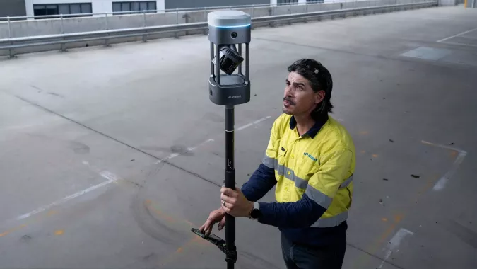
Emesent has launched its GX1 all-in-one mobile scanning system at Geo Week 2026 in Denver.
The GX1 is an integrated, highly accurate all-in-one mobile scanning system combining simultaneous localization and mapping (SLAM), lidar, real-time kinematic (RTK) georeferencing, cameras and software. The product marks a breakthrough for the autonomous mapping technology company.
The GX1 supports a seamless workflow, from capture to validated deliverable. It not only brings Emesent’s proven SLAM technology to everyday surveying applications, but also eliminates the longstanding trade-off faced by survey firms and players in the architecture, engineering and construction (AEC) industry between mobile scanning speed and dependable survey-grade accuracy.
According to Emesent, the GX1 can reduce the time required to survey a site by up to 95%, reducing what once took weeks into a single day of scanning. Meanwhile, the independently validated global accuracy of 5-10 mm delivers the precision needed for use cases across topographic and road surveying, scan to building information models, construction progress tracking and more.
These capabilities are supported by integrated RTK georeferencing with real-time quality monitoring, four 20MP cameras for 360° panoramic imagery, and Emesent’s proven SLAM algorithm. This technology — which also powers the Emesent Hovermap product — was developed and validated in extreme real-world environments, including GPS-denied, underground locations to ensure repeatable accuracy and reliability both indoors and out. Accuracy validation reports are produced quickly and easily in the Aura processing software.
With four purpose-built deployment modes — backpack, survey pole, vehicle mount and supported handheld — and integrated batteries for cable-free management, the GX1 offers a high degree of versatility. In addition, surveyors can capture data using RTK in the field or using ground control points and checkpoints in post-processing. This flexible georeferencing minimizes the risk of having to return to a site for redo.
“With the introduction of the GX1, we’ve answered the call we’ve heard echoing throughout the surveying industry to end the tug-of-war between fast and accurate,” said Dr Stefan Hrabar, chief strategy officer and co-founder of Emesent. “By putting the power of SLAM into the hands of the everyday surveyor, the GX1 raises the bar for mobile scanning accuracy and keeps critical projects on track.”
The launch of the GX1 comes at a pivotal moment for survey firms and the AEC industry. They are grappling with a shortage of experienced surveyors, while also facing mounting pressure from clients demanding faster, cheaper and better results without compromising on quality. The GX1 has been designed to be simple enough for junior surveyors to train on and deploy in a matter of days. At the same time, it is powerful enough to meet — and, according to Emesent, exceed — the real-world needs of professionals in the field.
Autonomous mapping company Emesent has launched the Emesent GX1, an integrated simultaneous localization and mapping (SLAM) and real-time kinematic (RTK) scanner. The company is exhibiting the GX1 at Geo Week 2026 (booth #911).
The product achieves 5-10mm global accuracy to deliver high precision for topographic surveying and building and infrastructure construction. It can reduce the time required to survey a site by up to 95% with a single day of scanning replacing weeks of work, Emensent stated in a press release.
The GX1 is an integrated, all-in-one system where lidar, RTK, cameras and software work together seamlessly from capture to validated deliverable. Its SLAM technology was proven in the world’s most challenging environments to everyday surveying applications, but it also eliminates the longstanding trade-off faced by survey firms and the architecture, engineering and construction (AEC) industry between mobile scanning speed and dependable survey-grade accuracy.
Suited for use cases across topographic and road survey, scan to building information models (BIM), construction progress tracking and more, the GX1 is simple enough for junior surveyors to train on and deploy in a matter of days yet powerful enough to meet the needs of experts in the field.
Accuracy. GX1 is the only SLAM-based mobile scanner system delivering 5-10mm global accuracy combined with rapid scanning capabilities. Incorporating client-first design, integrated RTK and Emesent’s proprietary SLAM algorithm, GX1 offers repeatable results survey firms can rely on.
Proven SLAM algorithm: Emesent’s SLAM technology, which powers its award-winning Emesent Hovermap product, was developed and validated in some of the most extreme real-world environments, includidng GPS-denied underground locations. It delivers repeatable accuracy both indoors and out.
Versatile deployment: GX1 has four purpose-built deployment modes: backpack, survey pole, vehicle mount, and supported handheld. Flexible georeferencing minimizes the risk of having to return to a site for redo – surveyors can capture with RTK in the field or with ground control points and checkpoints in post-processing.
The GX1 is being launched at a pivotal moment for survey firms and the AEC industry, which are grappling with a shortage of experienced surveyors, Emensent stated. At the same time, firms face mounting pressure from clients demanding faster, cheaper and better results without quality compromise, alongside the diminishing competitive advantage of adopting basic mobile scanning technology.
“With the introduction of the GX1, we’ve answered the call we’ve heard echoing throughout the surveying industry to end the tug-of-war between fast and accurate,” said Stefan Hrabar, chief strategy officer and co-founder of Emesent. “By putting the power of SLAM into the hands of the everyday surveyor, the GX1 raises the bar for mobile scanning accuracy and keeps critical projects on track.”
Technical Features
Independently validated 5-10mm global accuracy
Integrated RTK georeferencing with real-time quality monitoring
4 x 20MP cameras for 360° panoramic imagery
Emesent SLAM algorithm
Four deployment modes: backpack, survey pole, vehicle mount, handheld
Integrated batteries for cable-free management
Rapid accuracy validation reports in Aura processing software.
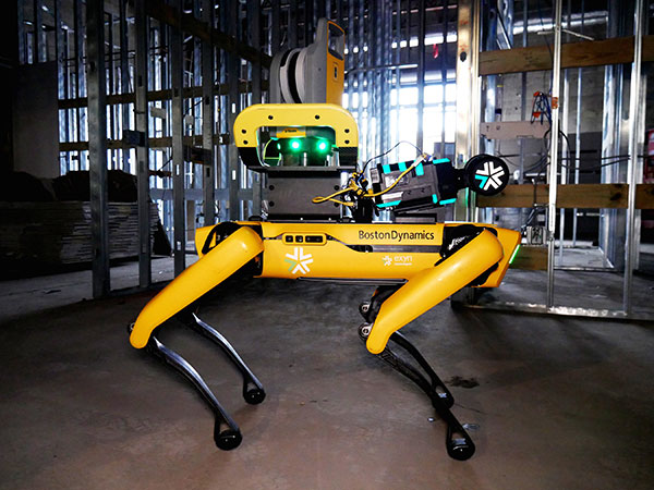
Trimble and Exyn Technologies are developing multi-platform robotic autonomy for complex, GPS-denied environments. (Photo: Trimble)
Trimble and Exyn Technologies are working on a proof of concept for a fully autonomous surveying solution for construction.
The solution will integrate the Boston Dynamics Spot robot, the ExynPak powered by ExynAI, and the Trimble X7 total station. It will enable fully autonomous missions inside complex and dynamic construction environments, which can result in consistent and precise reality capture for production and quality-control workflows.
Autonomous robots powered by ExynAI can sense and avoid obstacles, dynamically adapting to the complexity of construction environments. To ensure safety and efficiency, the ExynPak integrates with a robot, supporting Level 4 of autonomous exploration missions without requiring the robot to “learn” about its environment beforehand.
A surveyor can define a 3D volume for a mission, and then the integrated robotic solution handles the complexities of self-navigation without needing a map, GPS or wireless infrastructure.
The integration of the Trimble X7 provides high-speed, high-accuracy 3D laser scanning to capture the state of the environment. The captured data can be uploaded to the Trimble Connect collaboration platform and shared with project stakeholders for further analysis, including a comparison to building information models (BIM) and previous scans to monitor quality and progress. The result is a detailed and accurate map collected with minimal human intervention and risk.
Exyn and Trimble will be demonstrating their technology at the Trimble Dimensions+ Conference Nov. 7-9 in Las Vegas.
INTERGEO, a huge geospatial conference, was hosted in Essen, Germany and digitally on October 18-20. The event was attended by 457 exhibitors from 31 countries and about 14,000 trade visitors from 102 countries. “The results clearly exceed our expectations. We are very pleased to finally be able to bring many people together again with the live event,” explained Prof. Dr. Hansjörg Kutterer, President of the organizer, DVW e.V., Association for Geodesy, Geoinformation and Land Management.
This year, INTERGEO placed a focus on digital twins. Cooperation, collaboration and the sharing of information are crucial for the success of the digitalization of city, country and space. Other focal points of this year’s INTERGEO included smart cities, building information modelling (BIM), sustainability, mobility, and climate change.
The EXPO, the event’s exhibit area, presented a broad portfolio of the geospatial industry. In addition to terrestrial recording and airborne solutions such as drones, exhibitors also presented automated solutions for recording space. Geoinformation systems and BIM solutions demonstrated their potential in data analysis, monitoring and decision support.
The DVW is also working to raise awareness for the geospatial sector and to demonstrate its potential. For the first time, Prof. Kutterer awarded the newly created “DVW Future Prize” to the “Connected Urban Twins” project with the participating cities of Hamburg, Leipzig and Munich. The DVW Future Prize is awarded for groundbreaking ideas of outstanding interdisciplinary and social significance.
To promote young talent, the DVW presented the “INTERGEO Next Generation Science and Geoinnovation Award,” honoring outstanding pitches on young researchers’ work. This year’s winner, Steffen Becker from the Karlsruhe Institute of Technology, was awarded for his master’s thesis on traffic monitoring with drones.
Next year, INTERGEO will take place in Berlin, October 10-12.
Hexagon AB, which offers digital-reality solutions combining sensor, software and autonomous technologies, will integrate AVVIR’s artificial-intelligence-powered technology stack into its portfolio of solutions that address challenges of the construction lifecycle.
Since 2017, AVVIR has enabled intelligent, data-driven job sites that empower commercial, infrastructure and industrial construction professionals to reliably and safely deliver on schedule and within budget, Hexagon stated in a press release.
AVVIR’s reality-analysis platform is focused on building information modeling (BIM). It is designed to improve project workflows, schedules and outcomes by leveraging onsite reality-capture data, enriched BIM models and artificial intelligence. The solution gives construction teams control with automated schedule tracking, cost and earned value analysis, installation issue detection, and an updated BIM with as-built conditions.
The INTERGEO Expo & Conference focuses on innovations for a smarter world. INTERGEO 2022 will take place October 18-20 in Essen, Germany.
Topics including the importance of geoinformation for internal security, monitoring for disaster control and prevention, open data, digital twins alongside their use in construction and housing, mobility, sustainability and climate change, BIM and engineering applications with UAV, laser scanning and monitoring will be discussed during the 2022 event.
Additionally, the outdoor area of Messe Essen will show live demonstrations of the latest UAV applications in surveying, agriculture, construction, security and many more.
According to INTERGEO organizers, 300 international companies are already registered at the Expo, from innovative young start-ups to international key players such as Autodesk, Esri Inc., Hexagon, Trimble, Topcon and many more. The organizers expect around 500 exhibitors by October.
“All the international key players in the industry will be there.There was no doubt about it – they all want to get back to their customers, to visitors, to the live atmosphere and the power of meetings”, says Prof. Dr-Ing. Hansjörg Kutterer, President of the organiser DVW e.V., Association for Geodesy, Geoinformation and Land Management.
For those who are unable to attend the event in Germany, there will be some opportunities to participate in the Expo remotely.
Up close and personal
Digital Twins will receive their big break at the Conference 2022. Their use in building information modeling, smart planning and construction as well as mobility will be the focus of the event. Digital twins will be used to further development of urban data platforms in the context of smart cities and their variety of applications, as well as the use of smart city solutions in terms of innovation and sustainability and a basis for predictions and scenarios in the event of disasters.
The main topics in 2022 are Digital Twins and their value creation, 4D geodata and Geospatial IoT, potentials of remote sensing, BIM 4.0, industrial surveying, measurement systems and robotics, smart cities and mobility in the context of climate change and sustainability, mobile mapping, web services and GeoIT in disaster relief, spatial reference and positioning, earth observation and Galileo.
Hansjörg Kutterer points out the high innovative power of the industry: “We are experiencing high dynamics in segments such as mobility, environment and sustainability, climate protection and urbanization. Geo-IT has positioned itself as a solution provider for these topics. Problem-solving without Geo-IT is unthinkable in these subject areas. Come to Essen on the 18th to 20th of October and visit Intergeo Expo and Conference.”
How to attend
Tickets for INTERGEO are now available. An early-bird registration rate is available until August 31. Tickets can be found at https://www.intergeo.de/en/tickets.
Registration for new exhibitors is open as well. All information, such as application procedures and funding amounts, can be found on the INTERGEO website at www.intergeo.de/en/.
London building-design agency DCSK is using 3D building models from Bluesky to inform the design of high-profile urban residential developments.
Derived from the most up-to-date and accurate aerial photography, the Bluesky 3D models allow DCSK to place a design within its real-world context, consider sensitive view and vantage points, and communicate ideas to clients, planning authorities and the public.
DCSK has used a number of models from Bluesky, including a detailed representation of central Birmingham for the design of a 24-storey student accommodation on Lancaster Street.
“We have always had to consider how a design sits within the existing cityscape and how it will interact with the buildings and infrastructure that surround it,” said James Khamsi, Director of DCSK. “Before geographically accurate computer representations, such as the Bluesky 3D models, were available and affordable, we relied on a combination of site photographs and traditional 2D maps. This was a crude workflow that raised potential concerns about the currency and accuracy of information that was informing both the design and resulting planning permissions.”
DCSK is using 3D models from Bluesky for projects such as Curzon Circle Student Accommodation and others.Photogrammetrically derived from stereoscopic aerial photography, the Bluesky models are fully rendered and are provided as either wireframe or block models in a format suitable for use in both CAD and GIS software.
All Bluesky 3D models are supplied with a digital terrain model (DTM) depicting the topography of the underlying surface.
DCSK imports the Bluesky data into its 3D modelling software Rhino, where it is used to create a background layer for the design. The development site is isolated, and this data removed from the background layer, allowing for the detailed design to be dropped in. The proposed development can then be viewed and analyzed in its real-world context with detailed assessments of access ways and viewpoints, for example.
“The Bluesky models allow us to inhabit the site and experience the design as if we were there,” said Khamsi. “We can explore potential sensitivities, and, as the models are agile, we can massage the design exploring different options without leaving the office. The Bluesky models are also intuitive and therefore easy to interpret allowing us to communicate complex design ideas.”
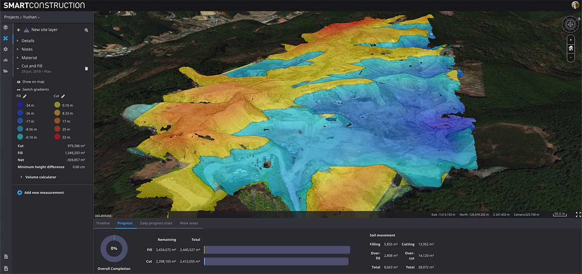
Cesium’s 3D technology will power smart construction dashboard to make construction safer, more efficient and more profitable
Komatsu has officially announced an incoming suite of the company’s Smart Construction solutions, which will include the 3D visualization power and geospatial accuracy of Cesium, a platform to visualize, analyze and share 3D data.
“Together, Komatsu and Cesium are bringing a new era of innovation to the construction industry,” said Rod Schrader, Chairman and CEO of Komatsu’s North American operations. “As experts in 3D data visualization, computer graphics and open-source software, Cesium’s technology will help power our Smart Construction Dashboard.”
Komatsu made the announcement at ConExpo 2020, held in Las Vegas.
As the key strategic partner for 3D data visualization, Cesium built the company’s Smart Construction dashboard. The dashboard enables users to monitor a construction site from anywhere in the world, see how it changes over time and compare architectural plans with real-world data.
It is compatible with different types of data — collected from sensors on individual construction machines, drone surveys, or computer generated files like BIM/CAD models — allowing users to visualize them all in a single scene within a web browser, as well as calculate precise measurements for cut and fill, slope, contours and more.
As Komatsu noted today, the worldwide construction industry is on the cusp of rapid change and innovation driven by technology. Collecting data from people and machines — and connecting all of it across an open platform — optimizes processes and delivers insights that will enable customers to make data-driven decisions.
Komatsu chose to partner with Cesium because of its powerful 3D visualization engine and accuracy in tying data to precise locations on the globe. Cesium’s ability to keep millimeter-level accuracy while tracking satellites in complex orbits was important to attain the level of precision Komatsu’s Smart Construction initiative demands.
“We believe in Komatsu’s vision to create construction sites that are safer and more efficient through Smart Construction.” said Cesium CEO Patrick Cozzi. “We are proud that visualization and analytics with the hallmark precision of Cesium will provide technology for the industry’s digital transformation.”
As we close the book on 2019 and head into the next decade, much has changed during the 2010s and the 21st century. This article will focus on the technological changes that made a significant impact on the surveying world, with the biggest advances being specifically GNSS-based improvements.
No, we will not debate the true beginning of a century (Jan. 1, 2000, versus Jan. 1, 2001), but instead look at the predicted issues with computers and the Y2K hysteria leading up to the end of 1999 as part of our nostalgic tour.
For the millennials and Gen-Z readers, bear with us old-timers for a few paragraphs while we take a trip down memory lane.
The tale of two centuries…
“It was the best of times, it was the worst of times, it was the age of wisdom, it was the age of foolishness, it was the epoch of belief, it was the epoch of incredulity, it was the season of Light, it was the season of Darkness, it was the spring of hope, it was the winter of despair, we had everything before us, we had nothing before us, we were all going direct to Heaven, we were all going direct the other way — in short, the period was so far like the present period, that some of its noisiest authorities insisted on its being received, for good or for evil, in the superlative degree of comparison only.”
In 1859, Charles Dickens wrote this opening paragraph for his well-known novel, “Tale of Two Cities,” to describe two environments (in this case being London versus Paris) at a significant transitional time. Such was the case for surveying and technology in the late 1990s with the rapid utilization of GNSS technology, expanded capability of robotic equipment and data collection. Some practitioners were excited about the new century while others yearned for bygone eras of less complicated procedures.
“Gonna party like it’s 1999…”
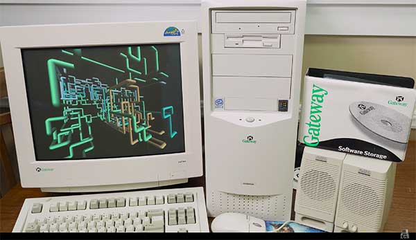
A 1999 Gateway PC refurbished by LRG. (Screenshot: LRG video, click to view)
With apologies to the late singer Prince and his 1982 hit song, the news surrounding the year 2000 was bleak when it came to computers and technology. For many of our readers, the technology available in 1999 might seem like the Stone Age. Most homes still used telephone land lines, “state of the art” cellphones were being produced by Nokia, personal computers (manufactured by Dell, Gateway, HP and IBM) were utilizing Pentium III processors (at a whopping 450 MHz!) with 5-10 GB storage. Internet Explorer was the web browser of choice, and Napster was gaining users exponentially sharing music downloads. Google was only one year old but rapidly replacing AltaVista and WebCrawler for our internet search engines. Life seemed good, but a storm was brewing…
The Y2K bug was front and center in all media outlets as many computerized systems were not programmed with the year 2000 in mind. This issue was unique in that it was a software and hardware problem to address. Replacement or patching of software, while taking a significant amount of time and money, can be much easier than computers and hardware loaded with chipsets that cannot be reprogrammed.
The Napster logo
Most system programming utilized a two-digit year designation instead of a four-digit version (99 versus 1999) and thus a date entry for January 1, 2000, normally composed as 1/1/00 in older systems would be recognized as January 1, 1900, instead. Because of this situation, many experts were predicting a global meltdown with government, utility company and banking disruptions that would render most computer systems unusable.
In the United States alone, over $100 billion was spent on computer upgrades and troubleshooting of the potential crisis. Thankfully, most of these systems had already been taken offline and replaced, but a few still lingered in critical systems. Because of pre-Y2K upgrade planning, many systems were tested and proven to be immune from the potential crash.
Specific Y2K issues that took place within the U.S. satellite system were isolated mostly to the units dedicated to surveillance, and not the navigation section used by surveyors. There was a small issue with the U.S. Naval Observatory, in which the date was deemed to be “Jan. 1, 19100” but that was rectified quickly.
The U.S. spy satellites, however, were knocked out by a faulty software patch rather than the original programming. These units were producing unusable information for three days before programmers were able to fix the problem. Imagine if that situation had happened to the navigational satellites and was impacting surveyors; we can only hope the GNSS system would have simply provided obvious bogus information.
Embracing RTK
By 1999, surveying had begun to embrace RTK systems for everyday measurement needs. Because of the constant focus of GPS technology moving forward, the operating systems for RTK were ahead of the curve for the Y2K issue. Fortunately, the navigational satellites as mentioned above did not fail with the date and time issues that were being predicted.
Logo of the now-defunct U.S. government Y2K website.
The Y2K bug did, however, affect a few users of older technology and software. Older data collectors, including ones based upon handheld calculators, were susceptible to date issues. Systems that were designed in the 1970s and ’80s should have been replaced with newer technology before 2000, but old surveyors stick to the adage: “If it isn’t broke, don’t fix it!”
For many, it wasn’t simply an upgrade in technology, but more of a radical change in known processes and procedures. New instruments and data collectors required new computers, which required new software, which required learning a completely new system.
Handheld GPS technology, introduced in the mid-1990s, was beginning to grow as the general public was embracing the new ability to determine geographical positions. While their use is quite simplified by today’s standards, nonetheless these devices captured the tech lover’s need for more accurate location determination.
In the end, Y2K wasn’t nearly the technological apocalypse many educated minds feared. While there were a few isolated incidents worldwide, everyday life went on without much of a blip on the radar. Planes didn’t fall out of the sky; financial systems didn’t come crashing down and life went on. Thankfully, surveyors everywhere went about their business on Monday, Jan. 3, 2000 as if nothing happened.
Then 20 years go by…
The new millennium has brought the surveying community many new exciting technologies and vast enhancements to age-old procedures. Field book notes has been mostly replaced with electronic data collectors, cellphone cameras and point clouds. Data is efficiently transferred between field and office with a remote connection and a blink of an eye. These past 20 years has seen a landslide of technological improvements, yet the future looks incredibly bright with more to come.
With the new year and decade, let’s look at where we are today and what advances we are anticipating:
GNSS CAPABILITY
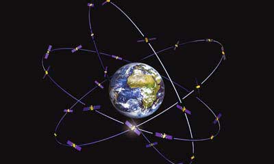
GPS (Global Positioning System) began working in the U.S. in 1978 and as a true global system in 1994. This system was originally designed to work strictly for the United State military, but was discovered to have consumer applications shortly after implementation. There are currently 30 operational satellites in the GPS constellation with two (2) Block III versions being evaluated at press time. A total of ten (10) Block III satellites are planned to be operational by late 2023 or early 2024. These Block III versions will have an enhanced signal capability (L5 band) and will provide more accuracy and increased protection from jamming and spoofing.
GLONASS (GLObal NAvigation Satellite System) is the navigation system designed and implemented by Russia. This system was deemed operational in 1993 and currently has 28 operational satellites. Most surveying equipment in the United States has GLONASS tracking capability to greatly increase the accuracy and precision of most GNSS receivers.
China launched two more BeiDou satellites on Aug. 25, 2018. (Photo: CCTV)
Galileo is the satellite constellation system created by the European Union. It reached limited capability in 2016 with full expanded reach targeted for 2020. However, the reliability of the system is now in question as a total system outage occurred for seven days in July 2019. The satellites themselves were operational; it was the main control center that experienced the shutdown during a system maintenance upgrade. The overall integrity of the system has been restored and the planned rollout of full operational capability is still scheduled for 2020.
BeiDou, the national navigation system of China, has achieved 35 operational satellites with 13 additional vehicles currently being evaluated for implementation. With the increased number of satellites, many GNSS receiver manufacturers are including BeiDou as standard channel reception to greatly increase accuracy and precision for navigational purposes.
Two additional regional systems, QZSS (Quasi-Zenith Satellite System) from Japan and IRNSS (Indian Regional Navigation Satellite System) from India are currently working to install more satellites and provide navigation signals soon. Because these are regional systems, access to these signals for U.S.-based surveyors will not be available.
In 20 short years, we went from having two good systems to four very robust systems and two regional organizations.
While it is still unclear how political relationships will affect the ability to use a system from another country, the simple fact is that more vehicles in space will only increase the coverage, reliability and effectiveness of GNSS navigational data. Increased signal type and strength will also provide many benefits, so surveyors should look forward to even better GNSS days ahead.
ADDITIONAL CELLPHONE CAPABILITY
Several increases in cellphone technology will greatly enhance not only the consumer’s use of GNSS but the surveyor’s. This involves a two-step increase in value with the rollout of 5G signal technology and dual-frequency GNSS receiver hardware within the cellphone.
5G is being introduced in various markets around the country, but won’t see full potential until 2021 and beyond. Those who can use it in the short term will see greater bandwidth for data connectivity, but surveyors will start utilizing navigational enhancements because of the signal and transmitter technology.
Add to this mix the future implementation of dual-frequency GNSS chipsets to provide much more accurate location, and the surveyor will have more data-collection power in their pocket. Dual frequency was a gamechanger for GPS receivers in their infancy, so one can only imagine how much it will enhance the navigation accuracy when included in the cellphone.
REAL-TIME NETWORKS (GNSS)
Most urban and suburban surveyors already enjoy the benefit of a real-time network, either from a private or public system. With 5G and expanded use of more satellites and L5 signal, the RTN will become a better tool for surveyors everywhere. A reduction of setting up a base station increased productivity, less theft and less equipment costs. The RTN will become a standard operational tool just like having a total station in your survey rig.
DATA COLLECTORS
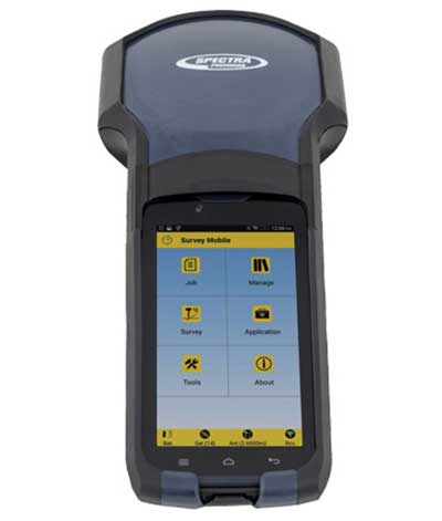
Photo: Spectra Geospatial
The technology hasn’t stopped with the unveiling of new data collectors and platforms. Small handheld devices used to rule the field surveyor’s world; now those devices have become bigger and more advanced than ever.
While most collectors already had touchscreens, the actual screen is increasing in size and functionality. Some are adopting the tablet-style format (8- and 10-inch screens), others are incorporating larger screens (7 inches) within the body of the traditional collector. All of them are including better cameras and enhanced connection capability through Wi-Fi, Bluetooth and cellular methods.
Also catching on is the use of bring-your-own-device (BYOD) with specialized apps for connecting to newer GNSS receivers. This allows surveyors to keep down costs of equipment by not having to purchase a dedicated data collector. As mentioned previously, once the cellphone becomes equipped with 5G and/or dual-frequency GNSS, it will become an excellent system for surveying that will produce extraordinary value for the surveyor.
SPATIAL DATA
The biggest revolution for surveyors in the coming years will be the ability to collect spatial data through a variety of equipment and sensors. Besides the obvious explosion of UAV capability, the small-format laser scanner is becoming user- and drafter-friendly as well as much more affordable. Now a surveyor can perform dozens (if not more) of small area scans with simplified orientation and scan formatting to create a great looking point cloud for data extraction and/or Building Information Modeling (BIM). Surveyors are beginning to understand how to utilize this technology and data to reach inaccessible areas and densified regions quickly. In addition to scanning technology, SLAM (simultaneous localization and mapping) will also become more mainstream as more surveyors are adopting the method for data collection.
What we’ve learned
“The days are long, but the years are short.” – Gretchen Rubin, author
Gretchen hit the nail on the head, as these past two decades have rolled on. When the end of 1999 was upon us, it seemed to be a big deal because of the potential of Y2K issues. There we were, surveyors with exciting technology in our hands, and now the forefathers of computers were going to erase it all due to not looking ahead to the next century.
We easily got past it, yet the memories of Y2K still linger on for some of us. The jump to 2010 didn’t foreshadow any drama (other than climbing out of a recession) and I personally didn’t think any different while moving the calendar to January 2020. But somehow in the last few months of 2019, there were many stories about the Y2K predicament, and it rekindled old memories of those weeks leading up to January 1, 2000.
Long story short, we survived and lived to survey many more days. Having time to look back and compare where we were 20 years ago to where we are now, I find it simply amazing. No, Rick Deckard isn’t flying by in his car catching bad guys (Blade Runner was set in 2019!), but surveying continues to amaze me with continued technological changes.
The development of augmented reality as a tool to manage and visualize hidden infrastructure assets has taken a major step forward following the announcement of a partnership between two technology companies.
MGISS, a U.K. geospatial specialist, has partnered with Canada-based vGIS to transform traditional GIS, BIM and CAD data into stunning augmented-reality visualizations.
Augmented reality provides an interactive experience of an environment where objects that reside in the real world, such as underground pipes, are displayed and enhanced with additional intelligence such as attribute information and maintenance records.
A specialist in the use of geospatial technology in the utility, infrastructure and environment sectors, MGISS said it understands the demands for improved spatial data quality and the requirement to communicate complex, asset dense, 3D environments in an easy-to-consume way.
Photo: MGISS
By combining authoritative survey-grade positions and associated data with consumer-grade hardware MGISS enables users of vGIS to access augmented reality visualizations from any suitable smart device.
vGIS is the leading augmented and mixed reality visualization technology for GIS data. Using the vGIS system, field personnel can see an augmented view that includes holographic infrastructure objects, improving environmental assessments and increasing situational awareness.
“Initiatives such as digital twinning and the expectation of ‘business as usual’ operations require the capture and representation of increasing complex real-world environments. Asset owners and operators face a number of challenges and opportunities including the need to improve safety, reduce risk and ensure what lies beneath our feet meets future infrastructure needs,” said Mike Darracott, managing director and founder of MGISS.
“vGIS truly understand the needs and the challenges facing these sectors. In fact, vGIS goes further than any other Augmented Reality solution by providing a full range of 3D spatial data capabilities; all within a platform that works with existing enterprise systems and data structures,” added Darracott.
“Value is often hidden deep within the structure of data. By helping people ‘see’ data in more intuitive ways, they gain new insights and can subsequently do more with that information. That’s been the core operating philosophy of vGIS,” said Alec Pestov, founder and CEO of Canada based vGIS. “To achieve this we are building an ecosystem bringing together top experts to work jointly towards a common goal. MGISS possesses deep expertise in the spatial services and solutions sector and we are looking forward to joining forces to deliver augmented and mixed reality visualizations in the UK.”
Topcon Positioning Group released a new strategy through its Topcon Solutions Store retail channel. Together with Autodesk, and as an Autodesk Platinum Tier Partner, the Topcon Solutions Stores retail channel plans to expand top-tier service to civil-construction and BIM professionals through acquiring and adopting automation into its workflows.
The plan calls for a shift from traditional retail “box moving” sales approach, to a complete solution offering that combines hardware, software, and services. In order to deliver best-in-class service, training, and support, the plan includes renovation for 11 Topcon Solutions Store facilities in preparation to obtain their Autodesk Authorized Training Center (ATC) designation — joining two more store locations that are already approved Autodesk Training Centers.
The Autodesk Platinum Tier partner designation indicates the highest level of reseller status, and will allow TSS to continue to grow with significant investment in training, consulting and development services.
Mark Contino, Topcon VP, North American Retail Distribution, said, “By combining Topcon’s precision measuring and positioning hardware with Autodesk’s world-class software portfolio, the Topcon Solutions Stores seamlessly provide complete end-to-end workflows that greatly improve productivity and efficiency. Soon, all 13 locations across the U.S. will be repositioned to deliver the highest level of training, support, and workflow consulting services in the civil construction and BIM space. Not only will Topcon Solutions Stores be able to help customers analyze operations, every location will also help all the way through implementation and on-going support with local, professional training programs.
“The renovation of our facilities across the U.S. is part of our dedication to offer the modern solutions centers that the industry demands to provide this service,” Contino said.
Kirk C. Givens, senior manager, Autodesk Americas Channel Sales, said, “Topcon’s strategy to deliver a complete end-to-end solution in the civil-construction and BIM space is exciting. It’s truly game changing to be able to deliver a complete workflow combining two world class solutions – Autodesk software and Topcon hardware. Supporting that through 13 brick-and-mortar locations with professional training and support facilities will provide tremendous value to customers in the construction market.”
Pointfuse has developed smart software that automates the identification and classification of objects for facilities management applications using data from mobile mapping systems like the new Leica BLK2GO.
Pointfuse software converts the millions of individual measurements captured by laser scanning and photogrammetry into useable 3D mesh models. The unique ability to classify objects within Pointfuse, both automatically and manually, has already had a huge impact on how as-built data is used within design and construction. It can now realize real time records for space utilization and optimization projects, reducing costs and speeding workflows within facilities management.
The Leica BLK2GO. (Photo: Leica Geosystems)
Pointfuse Simple BIM (sBIM) leverages the core functionality of Pointfuse — the segmented mesh model; automatically converting classified mesh models into “family” groups, such as walls, floors, doors, windows, etc. for use with popular downstream BIM and FM software. Pointfuse sBIM data can then be exported as IFC (Industry Foundation Class) parametrized objects and 2D floors plans and space management reports easily derived. Pointfuse sBIM also automatically calculates quantities, areas and dimensions in an easy to read PDF report.
“This ability to convert classified objects into family place holders has a huge impact on how as-built data is used within a Scan2BIM workflow with the potential for a real return on investment for facilities and space management applications,” said Mark Senior, regional sales director at Pointfuse. “The combination of ease and speed of data capture, as offered by modern hand-held indoor mapping systems like the newly launched Leica BLK2GO, with the automation of Pointfuse processing will release the potential of laser scanning across this sector.”
Pointfuse sBIM was developed in response to a large scale client opportunity that saw the scanning of millions of square feet of facilities with the final deployment of data in Archibus facilities management software using Autodesk Revit as a bridge. Early testing identified that 3D was as quick to create as traditional 2D workflows and exported data is in the region of hundreds of Kbs compared to the Gb volumes of the original point cloud. Taking the process one step further Pointfuse provides an accurate record of the as-built scene by allowing users to create Hybrid meshes combining Pointfuse models with the sBIM IFC container.
Pointfuse will be showcasing the sBIM functionality at the Autodesk University (AU) Expo which takes place Nov. 19-21 at the Sand Expo Convention Centre in Las Vegas, Nevada.