The GPS Week Number Rollover, which took place April 6, has caused several automated NOAA stations to go offline.
Some of the outages could last until November.
Photo: NOAA
According to the EOS website, 19 National Oceanic and Atmospheric Administration (NOAA) coastal and marine automated stations were not updated to mitigate the issue, and those stations are out of commission until workers can service them on location.
The New York Times is reporting that at 7:59 p.m. EDT on Saturday, the New York City Wireless Network went dark, interrupting functions such as the collection and transmission of information from some Police Department license plate readers, Department of Transportation traffic-light programming, and communications at remote work sites for the sanitation and parks departments.
The city is now working overtime to bring affected systems back online, reports StateScoop.
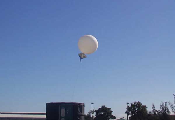
Previously, GPS World reported on rollover issue for the Australian Bureau of Meteorology’s (BOM) weather balloons, as well as Boeing aircraft. Read more about the Boeing issue here.
Launch of a weather balloon in Australia. (Photo: Townsville Meteorological Office/Bureau of Meteorology)
The GPS Week Number Rollover, which took place April 6, has grounded the Australian Bureau of Meteorology’s (BOM) weather balloons.
The fault was caused by the rollover of the time stamp in GPS signals, reports ABC news, which caused a “technical fault with the equipment’s communications systems.”
The weather balloons carry a radiosonde that includes GPS tracking. The radiosondes measure various atmospheric parameters and transmits them by radio to a ground receiver.
BOM said its equipment supplier advised the bureau of the fault after the rollover on April 7, and balloon launches ceased on April 8.
GPS clocks returned to zero early on Sunday morning.
Usually, BOM launches 56 weather balloons each day from 38 locations to provide vital information to help meet international obligations under the Convention of the World Meteorological Organization.
Boeing aircraft affected
Also affected by the rollover were some Boeing aircraft. The GPS clock rollover caused “a limited number of 787 airplanes” to display the wrong date, according to Boeing, causing them to be temporarily grounded in China.
Other reports are that at least one KLM 777 flight and a large number of China Airlines 777 and 787 aircraft were grounded due to the issues, while technicians updated the software. A Shanghai Airlines 787 was also reportedly affected.
In all the reported cases so far, the GPS systems were supplied by Honeywell, which issued a service update on the issue.
When managed by a new ground control system, GPS III satellites will offer triple the accuracy and eight times the anti-jamming capabilities of the satellites currently comprising the U.S. Air Force’s GPS constellation. Users military and civilian will reap ample benefits.
Everything changed for space-based positioning, navigation and timing around the world on Dec. 23, 2018. Or maybe it didn’t. The innovations heralded by the launch of the first GPS III satellite will take years more to occur. We tabulate here the advances that Generation Three will bring over GPS-to-date, and review the timeline for their actual arrival.
While these new capabilities exist — in concept — in space, they can’t be leveraged on the ground (or in the air, or at sea) until a sufficient number of additional GPS III satellites have joined the constellation, and until a new ground control system comes online. This will occur — perhaps — in 2023. At that time the satellites’ talents will be unleashed.
“As more GPS III satellites join the constellation, it will bring better service at a lower cost to a technology that is now fully woven into the fabric of any modern civilization,” stated Lt. Gen. John Thompson, commander of the U.S. Air Force’s Space and Missile Systems Center and the Air Force’s program executive officer for space.
The many GPS III upgrades should make the service more reliable and accurate for civilians, more secure against those who want to jam military users, and more cyber-secure for everyone.
TALKIN’ ‘BOUT OUR GENERATION
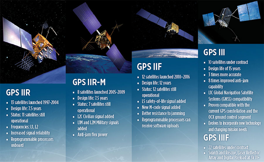
GPS constellations have grown through six major iterations since 1978. The sixth, GPS IIF, rose during the years 2010 to 2016. Those 12 satellites are all designed to last 12 years. Some of their notable features include the ability to receive software uploads, better jamming resistance and increased accuracy.
GPS III, the seventh generation, will launch nine more satellites to join SV01 already in space. GPS III SV02 is scheduled to launch in July of this year, SV03 in late 2019, and SV04 in 2020. The final III payload should rise in 2023. From that point on, the follow-on era of GPS IIIF takes over.
How Long, How Long? “Projections for how long the current constellation will [continue to] be fully capable have increased by nearly two years to June 2021, affording some buffer to offset any additional satellite delays,” reported the Government Accounting Office at the end of 2017. This provided some schedule buffer for launching the first GPS III satellite, but it did not reduce the desire to launch as soon as the booster rocket became available.
The new birds will introduce new capabilities to meet higher demands of both military and civilian users: once filled out, the GPS III constellation will bring three times better accuracy and up to eight times improved anti-jamming capabilities. Spacecraft life requirement will extend to 15 years, 25 percent longer than the latest GPS satellites and twice the original design life of the oldest satellites on orbit today.
The new L1C civil signal broadcast by GPS III is an interoperable signal with other international global navigation satellite systems, like Galileo, improving connectivity for civilian users.
GPS III will eventually actualize full M-code capability — carried aboard the IIR-Ms and IIFs but not yet completely implemented — in support of warfighter operations. GPS III M-code capability exceeds that of GPS IIR-M and GPS IIF.
GPS III will complete the deployment of the L2C civil signal and the L5 safety-of-life signal capabilities that began with \GPS IIR-M and GPS IIF satellites.
Finally, GPS III will enact improved integrity: the ability of the satellite to detect and issue alerts on its own reduced accuracy, should that phenomenon ever occur.
Military Signal Power Up. Encrypted M-code signals will be up to eight times more powerful than currently. This makes them more reliable. but also enables the sats to overcome efforts to jam their signals.
Other signals also offer increased signal power at the Earth’s surface. L1 and L2: −158.5 dBW for aC/A code signal and −161.5 dBW for the P(Y) code signal. L5 will be −154 dBW.
Family Features. The most recent generations of the GPS constellation. IIR, IIR-M and III were produced by Lockheed Martin, while IIF was built by Boeing. One GPS IIA satellite is still in operation, at 25 years young (design life was 7.5 years). All satellites carry Harris Corporation payloads. (Graphic sourced from: Lockheed Martin and Boeing Co.)
L SIGNALS
L2C, the second open GPS signal, after L1 C/A, has been available from every new GPS satellite since the first IIR-M launch in 2005. L5, the third open GPS signal, became available with the first IIF launch in 2010. Now L1C, the fourth open GPS signal, joins the band, broadcasting from every new GPS satellite, starting with the recent GPS III launch (see First Light).
The first GPS III satellite is in checkout and testing that could last up to 18 months before it enters service. “After its Dec. 23 launch, GPS III SV01 successfully completed its orbit raising and deployment of all of its antennas and solar arrays. On Jan. 8, the satellite’s navigation payload began broadcasting navigation signals,” said Johnathon Caldwell, Lockheed Martin vice president for navigation systems. “On-orbit testing continues, but the navigation payload’s capabilities have exceeded expectations and the satellite is operating completely healthy.”
Testing, Testing. Using the Air Force’s Back-to-Basics program, which involved early prototyping and simulations, Lockheed Martin developed GPS III with an approach that involved rigorous quality-build certificates, component testing and system-level testing. The comprehensive requirements verification and validation process ensured more than 30,000 requirements were achieved. The system functional qualification includes the performance verification in multiple environmental tests, including the acoustic, thermal vacuum (TVAC) and electromagnetic spectrum.
“We consider thermal vacuum the gold standard for testing any satellite before it goes into operations,” Col. Steve Whitney, director, GPS Directorate, wrote in GPS World in December. “It really is putting the craft through the paces. When it goes through the testing, the satellite is on. It is working. It is exposing it to the heat and the cold and the zero pressure while the satellite is functional. The entire thermal vac testing from start to end is about 70 days. Test like you fly. From the time it launches and deployment sequence, we test it like it is real. Minus the shaking, the satellite thinks it is getting launched. Meanwhile, our people are looking at the data and its health. TVAC is a huge milestone for a satellite to go through and come out no issues.”
To date, more than 90 percent of parts and materials for all 10 GPS III satellites have been received from more than 250 aerospace companies in 29 states.
BRAIN OF THE BUNCH
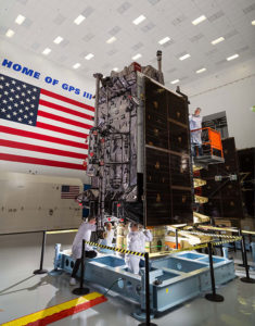
THE FIRST GPS III satellite was fully assembled and entered into SV single-line flow when Lockheed Martin technicians integrated its system module, propulsion core and antenna deck. (Photo: Lockheed Martin)
Harris Corporation is a subcontractor to Lockheed Martin for development and production of GPS III Mission Data Units (MDUs) and transmitters for the GPS space section. Six have been delivered.
The Harris MDU, together with the Atomic Frequency Standards and the L-band transmitter equipment, make up the Navigation Payload Element. The MDU performs the primary mission of the GPS satellite: generation of the navigation signals and data on a continuous basis. The MDU controls the generation of the precise timing signals used for navigation signals while distributing the timing signals to other satellite components.
This MDU is 70 percent digital. The next to come, aboard GPS IIIF satellites, will be fully digital.
When asked about the advantages of an all-digital payload, Harris Corporation’s Jason Hendrix, PNT program director, told GPS World in April 2018, “The advantages and the 30 percent difference are the timekeeping system portion. We’re moving from manual, analog timing to digital to deliver to the Air Force more flexibility. It’s a nice option to have to be able to reprogram in orbit and maybe enhance capabilities desired in the future.”
LIVING BETTER, LIVING LONGER
Greater mission longevity is one of the key improvements GPS III delivers over those currently in service. Space Vehicles 1–10 have a planned mission life of 15 years, 25 percent longer than their predecessors. That begs the question, “How long should a satellite live in space, with technology innovation occurring almost annually?”
Advanced payload technology provides a partial answer. Lockheed Martin and Harris point to new payload capabilities with built-in flexibility to adapt satellites in orbit to technology advances, as well as changes in missions. According to Harris, the fully digital navigation payload will provide the ability to change and upgrade the satellites incrementally over mission life.
In late 2017, Lockheed announced a partnership with NEC Corporation to introduce artificial intelligence for computer learning in orbit. The company touted significant advances in processors and a move toward next-generation antennas, arrays and transmitters to drive more satellite flexibility, capability and resilience.
FROM THE GROUND UP
GPS IIIF’s M-Code can be broadcast from a high-gain directional antenna in a concentrated, high-powered spot beam, in addition to a wide-angle, full-Earth antenna. (Artist rendering: Lockheed Martin)
GPS III’s military upgrades require new ground control stations, a replacement effort called OCX that has suffered repeated delays and cost increases, due to the complexity of the programming and requirements modifications. The new jamming-resistant military signal will not be available until the new, highly complex ground control system is available, and that is not expected until 2022 or 2023. Delay and cost considerations were driven in part by full implementation of all Department of Defense 8500.2 “Defense in Depth” information assurance standards without waivers, giving it the highest level of cybersecurity protections of any DoD space system.
Deliverables for GPS OCX are divided into three blocks. Block 0 delivery took place in fall 2017, enabling it to support the December launch. Block 1 delivery will take place in 2021, providing full operational capability to control both legacy and modernized satellites and signals. Block 2, delivered concurrently with Block 1, adds operational control of L1C and modernized M-code.
In 2018, wrote Col. Whitney of the GPS Directorate, “We have actively utilized the [Block 0] system in a variety of exercises, training events, compatibility tests and launch readiness events. We also completed a comprehensive security review of the system to demonstrate our readiness to start operations. The system is ready to go. We continue to work the development of the OCX Block 1 system and are wrapping up the initial coding of the system early in 2019, leading into our integration and test campaign.”
Given delays in OCX, “the Directorate is actively working two major upgrades to bridge the gap,” Whitney continued. “The first is GPS III Contingency Operations (COps) modification which will allow the 2nd Space Operations Squadron (2SOPS) to command and control the GPS III family of vehicles in a mission state matching today’s legacy signals for all users world-wide. The second modification is M-code early use (MCUE), which enables 2 SOPS to operationalize the Modernized GPS military (M-code) navigation signals for the warfighter.”
Before December’s launch, OCX underwent rigorous cybersecurity vulnerability assessments that tested the system’s ability to defend against both internal and external cyber threats. GPS OCX prevented the broadcast of corrupt navigation and timing data in all tests, bolstering the program’s readiness for GPS III.
“We’ve built a layered defense and implemented all information assurance requirements for the program into this system,” said Dave Wajsgras, president of Raytheon Intelligence, Information and Services. “The cyber threat will always change, so we’ve built OCX to evolve and to make sure it’s always operating at this level of protection.”
The new Harris navigation payload offers a smooth transition to use of OCX. The payload for the first 10 GPS III satellites has been verified for OCX compatibility so the same OCX commands will seamlessly port to the Harris fully digital design, minimizing integration risks and associated costs.
According the the GAO, “Full M-code capability —which includes both the ability to broadcast a signal via satellites and a ground system and user equipment to receive the signal — will take at least a decade once the services are able to deploy military GPS user equipment (MGUE) receivers in sufficient numbers.” The April 2019 issue of GPS World will review M-code implementation across U.S. DoD platforms.
THE FUTURE’S NOT OVER YET
In spring 2018, Lockheed Martin submitted a proposal for the GPS III Follow On (GPS IIIF) program, which will add enhanced capabilities to the satellites. New hardware — a high-gain directional antenna — aims signals in a spot beam at a limited area, but blasts the signal at high power for strategic use by the military.
Inter-Satellite Links. Block IIIF satellites will carry laser retro-reflectors to enable orbit tracking independently of the satellites’ radio signals, which in turn will allow satellite clock errors to be disentangled from ephemeris errors. A standard feature of GLONASS, this is included in the Galileo positioning system, and was flown as an experiment on two older GPS satellites, 35 and 36.
In September 2018, the Air Force selected Lockheed Martin to build up to 22 additional satellites under the GPS IIIF program.
The decision means Lockheed Martin is all but assured the contract. Lockheed Martin announced on April 17 that it had submitted its proposal.
All three companies received study contracts in 2016 valued at up to $6 million each to demonstrate their ability to build future GPS satellites, in preparation for the planned competition.
Boeing has decided to not submit a proposal to build up to 22 GPS III satellites for the U.S. Air Force. The GPS III Follow On (GPS IIIF) program will supply additional upgraded satellites to replace ones now in the constellation.
“We have not put in a proposal for GPS III,” said Rico Attanasio, Boeing’s director of Department of Defense and civil navigation and communications programs, to Space News.
Lockheed has been the only producer of GPS III satellites, and is now under contract to build the first 10. Boeing built earlier versions of GPS satellites.
In February, the U.S. Air Force Space Command (AFSC) released its request for proposals (RFP) to build the 22 GPS III satellites, called the GPS III Follow-On Phase 2 contract. The estimated dollar value of the acquisition is $10 billion including all options.
Phase 2 is planned as a single, predominantly fixed-price incentive-type contract awarded via full and open competition for production of 22 GPS III satellites. Deadline for proposals is April 16. Construction is to begin in fiscal year 2019 (Oct. 1, 2018), with delivery of the first satellite in 2026.
Boeing thought it could compete based on “innovation, resilience [and] a new payload, but that wasn’t emphasized,” Attanasio told Space News. “It wasn’t a good fit for us.”
The U.S. Air Force plans to release a request for proposal (RFP) for the second phase of GPS III Follow-On satellite production “on or about” Feb. 13, according to a report by Inside Defense.
The RFP was expected in December 2017, but was held up as officials worked to solidify requirements.
The solicitation is expected to result in a contract for up to 22 GPS III Follow-On satellites in the 2019 time frame.
Lockheed Martin is on contract to build the initial 10 GPS III satellites, the first of which is expected to launch this year. Besides Lockheed, Boeing and Northrop Grumman have both expressed interest in competing to produce the next batch of satellites.
The U.S. Air Force has awarded a $48 million contract to Aurora Flight Sciences for the continued development of the Orion unmanned aircraft system (UAS). Aurora Flight is a Boeing company.
Orion is a twin-engine high-performance UAS that can stay aloft over 100 hours at a time with payloads in excess of 1,000 pounds.
Development of the Orion started in 2006 and its first flight was in August 2013. In December 2014, the Orion established the UAS world endurance record with an 80-hour, 2-minute and 52-second flight.
The new contract funds the development of a certified version of Orion that will be suitable for deployment anywhere in the world. The work will be performed in Columbus, Mississippi, and Manassas, Virginia.
Boeing completed the acquisition of Aurora Flight Sciences in November 2017.
Boeing and the U.S. Air Force have signed a GPS sustainment agreement to ensure the health of current satellites on orbit. The agreement enables persistent GPS capability for civilians and the military as Boeing works on next-generation GPS satellites.
Artist’s impression of a GPS Block II/IIA satellite in orbit. (Credit: U.S. government)
Under the agreement, Boeing will support GPS IIA and IIF satellites on orbit for the next five years. Boeing, which has been the prime GPS contractor for more than 40 years, is now part of the Air Force effort that may lead to the next generation of GPS satellites.
“This agreement continues Boeing’s strong legacy of GPS innovation and mission support,” said Dan Hart, vice president, Government Satellite Systems. “We are focused on delivering reliable, affordable and resilient GPS capability now and for generations to come.”
Collectively, Boeing GPS satellites have accrued more than 550 years of on-orbit operation. In March 2016, the company delivered its 50th GPS satellite on orbit to the Air Force and has built more than two-thirds of the GPS satellites that have entered service since 1978.
The I-want-free-advice syndrome was once called the “Doctor Syndrome” or “Expert Syndrome.” I have recently heard it referred to as the “unsolicited advice” syndrome, because there is a new version that involves shaming the expert in to giving free advice.
Occasionally those of us with expertise in an area of interest, which certainly include doctors and lawyers, are faced with tough decisions involving rules, regulations, laws and conflicts of interest.
We are all guilty of these ethical violations in one way or another. On an airplane you discover your seatmate is a doctor of osteopathic medicine; not five minutes have gone by and you are telling him or her about all your aches and pains and seeking advice. My daughter, a clinical psychologist, says this frequently happens to her, but legally it is not a syndrome, although it could certainly be described as a phenomenon.
Regardless of the nomenclature, the newest wrinkle goes like this, as stated by a congressman at our table at a fundraiser I attended recently, when he was asked about the troubled OCX program (Next Generation GPS Operational Control System) and GPS funding in general. “Well, I don’t know much about GPS or navigating, but this is what I know about OCX and GPS. I am sure Don will correct me if I am wrong…”
I mention this phenomenon because for position, navigation and timing (PNT) issues, it is growing at an alarming rate. For instance, my 10-20 emails per day asking about PNT issues have grown over the past few weeks more than tenfold. I perceive that many of you are confused and concerned about the future of GPS, PNT and GNSS in general.
With the House Armed Services Committee deleting more than $420 million from the GPS budget line for OCX in the 2017 budget and canceling funding for certain Acquisition, Technology and Logistics (AT&L) positions dealing with acquisition, there are all kinds of rumors and innuendo floating around. [Editor’s Note: the Senate did not make the same deletions, so this must be worked out in congressional committee meetings before the end of September]. So, I went out and formally asked the experts (GPS Directorate, Lockheed Martin and Harris Corp among others) what they think the future holds for GPS. Here is what I learned…
Artist’s concept of the nextgen GPS III satellite (courtesy of the USAF).
GPS III Spacecraft. According to Colonel Steve Whitney (USAF), the director of the Global Positioning Systems Directorate, Space and Missile Systems Center (SMC), Air Force Space Command (AFSPC), Los Angeles AFB, California: “The GPS III program is actively engaged in production of the first eight [GPS III] satellites (SV), while proceeding ahead with contracting actions for the ninth and tenth spacecraft. “
Colonel Whitney went on to explain, “We have had several notable successes over the last year, including delivery of the first two navigation payloads [from Harris Corp] and completion of the first spacecraft’s environmental tests (acoustic, thermal vacuum and electromagnetic compatibility). As we prepare to accept delivery of the first spacecraft, the directorate is gearing up for the Mission Readiness Campaign and satellite launch.”
I spoke independently with representatives from both Harris Corp and Lockheed Martin, and they expressed the same opinions. Work is progressing toward a launch of the first GPS III SV hopefully sometime in 2017.
Of course, all of the companies mentioned and many others are also involved in the follow-on production of GPS III satellites known officially, oddly enough, as the:
GPS III SV11 + Follow-On Production Phase One (1). According to Colonel Whitney, “The GPS SV11+ program is implementing a phased acquisition approach to determine first if viable alternate sources exist for a production-ready spacecraft. We successfully awarded three Phase 1 contracts on 5 May 2016, and are working with all three vendors to inform our follow-on approach.”
For those of you who have not been keeping up, the three Phase 1 contracts were in the amount of $5M to each company. LMCO is included in the competition and was one of the three companies. To go into a bit more detail, the three GPS III awards are firm-fixed-price contracts that are not-to-exceed $6 million; the base contract plus two $500,000 options. The base contract period of performance is 26 months, and each option extends that time by six months for a total period of just over three years or 38 months.
At the end of the competition, the GPS Directorate will award one GPS III Phase 1 Production Readiness Feasibility Assessment contract to one or more of the three companies:
Colonel Whitney’s boss, Lt. Gen. Sam Greaves, who is the Space and Missile Systems Center commander and Air Force program executive officer (PEO) for space, said: “Industry told us they were ready to compete for the GPS III space vehicles. We look forward to working with Boeing, Lockheed Martin, and Northrop Grumman to assess the feasibility of a follow-on, competitive production contract.”
The USAF has issued an artist’s concept of the GPS III satellite, but seriously, I have listened to the proposals from all three companies in detail, and the proposals are all so radically different that the picture is just that, an artist’s concept, it may not even be close to reality.
Artist’s concept of the nextgen GPS III satellite (courtesy of the USAF).
Certainly, $5-6M is not much money in the scheme of things, certainly not enough to design and build a GPS satellite from scratch, but it is a show of good faith on behalf of the U.S. government, proving they are serious in their search for a new and improved PNT satellite in the GPS III family.
Next-Generation Operational Control System (OCX). The original OCX contract was awarded for somewhere slightly south of $900M for a six-year total effort to deliver a new Full Operational Capability (FOC) ground control system for all GPS satellites except the long-lived GPS IIAs. The federal government, having watched programs like OCX go south before, took the Raytheon bid and quietly doubled it and assured everyone they had the program well in hand. The government assured us time and again that OCX would never breach Nunn- McCurdy levels as they planned for double the cost. Smart move, but OCX costs finally reached double the original estimate plus 25 percent, which triggered the Nunn-McCurdy breach on June 30.
Now Raytheon and the government have until October to decide whether to continue with the OCX program. However, Colonel Whitney and the folks at SMC remain confident; he kindly describes the current status of OCX this way: “The OCX team continues to pursue a restructured plan approved by the Defense Acquisition Executive [USD (AT&L)] and will hold its next deep dive with the Secretary of the Air Force [SECAF] and USD (AT&L) in early July [maybe this week]. Raytheon is driving for Functional Qualification Testing of the GPS III Launch and Checkout System (GPS LCS and OCX Block 0) in August 2016.”
My sources tell me that a realistic date for OCX FOC, based purely on past performance, software issues and cyber-security concerns, is 2023 with a total cost of $4.2B. This may all be academic if OCX cannot clear the Nunn-McCurdy hurdles.
The interesting story here is that there are alternatives. This brings us to the…
GPS III Contingency Operations or Cops, which Colonel Whitney described this way when I asked him about it. “We [USAF, SMC] awarded the GPS III Contingency Operations effort on 3 February 2016 on an expedited basis with the task of delivering the capability to put on-orbit GPS III spacecraft into operations, providing legacy mission capabilities. We successfully completed the Preliminary Design Review (PDR) on 11 May 2016 and are on-track for Critical Design Review (CDR) in November 2016.”s
What the Colonel meant to say — my words, not his — is that we (the U.S government) are finally hedging our bets. Just in case OCX does not come to fruition, both for launch and operations, we know we need to put a GPS III satellite on orbit soon so we can check it out before all the satellites are produced and sitting in a warehouse and we discover a major anomaly. We are running out of time.
If all of the GPS satellites are produced (and there are only six or eight more to be built under the current contract depending on the future award schedule), and not one of them has been launched, then the program is in trouble. If LMCO does not win the follow-on contract, then the GPS III production line will be shut down at LMCO and experts scattered to the winds. Spare parts for a satellite in storage will be hard if not impossible to find, much less repair or install. If the first GPS III satellite is not launched until after production ceases and a major flaw or anomaly is discovered, then the government’s options are slim to none.
To prevent a worst-case scenario, the government must launch a GPS III satellite, and soon. Certainly a date in 2016 is preferable, but a 2017 date will suffice, according to my sources. However that is doubtful with an OCX-based launch program that has yet to launch a satellite.
Kudos to the government for looking at OCX alternatives, and for looking down the road at…
Military GPS User Equipment or MGUE. Colonel Whitney, who successfully ran this program for several years before becoming the overall GPS SPO director, knowledgeably described the current MGUE effort this way. “We have taken delivery of the first GPS Military GPS User Equipment (MGUE) Final Test Articles this past month. These articles are going through initial checkout in the test labs as we prepare for integration into our lead platforms, like the B-2 Bomber.”
Approving the final test articles is a big deal for MGUE because it not only puts the products in the hands of operational integrators and users, but opens the door for a multitude of changes necessary to incorporate the latest up-to-date technology. This technology hopefully includes the use of GNSS signals and capabilities as well as other PNT signals and augmentations that can now be incorporated.
By the way, the congressman at the fundraiser dinner that I mentioned at the beginning did a credible job, but managed to get most of it wrong. But then, congress has so much more on its plate than GPS. That’s why the real experts need to make sure they keep everyone informed.
Wooldridge and Ramo on the cover of Time Magazine, 1957.
Simon Ramo
I hate to end on a sad note, but I must acknowledge the passing of a legend in the aerospace industry. Dr. Simon “Si” Ramo, who I knew well and worked with for many years early in my career, passed away on June 27 at the age of 103.
Si, who held two doctorates, was already a leader in the aerospace industry when I was born, and I credit many of his well-known books (he was a prolific author) for drawing many a young person to space, rockets, the dynamics of space launch, and engineering.
Dr. “Si” Simon Ramo
Si cofounded TRW Inc. in the late 1950s by taking two companies — Ramo-Wooldridge and Thompson Products — and leading them into the ICBM (Intercontinental Ballistic Missile) world. He was a tireless promoter of the space industry. The world will not soon see another character, gifted leader and entrepreneur like Si Ramo.
Until next time, happy navigating, and remember: GPS is brought to you free of charge by the United States Air Force.
Insitu has been awarded a US$71 million follow-on contract to produce six RQ-21A Blackjack unmanned aerial systems (UAS), with options for two more, from U.S. Navy Naval Air Systems Command (NAVAIR).
The RQ-21A is recovered with the flight recovery apparatus cable aboard the San Antonio-class amphibious transport dock USS Mesa Verde after its first flight at sea. The tests were held in the Gulf of Mexico on Feb. 10, 2013.
The RQ-21A Blackjack has significantly larger payload mass, volume and power than other small UAS currently being used in theater, according to Insitu, a subsidiary of The Boeing Company. The system includes electro-optic and mid-wave infrared sensors with a laser rangefinder and infrared marker.
The Low Rate Initial Production (LRIP) Lot V contract also includes an option year for nine Full Rate Production (FRP) systems. The FRP decision review is expected this fall.
“This contract award paves the road for Blackjack’s continued and future fleet integration,” said Col. Eldon Metzger, program manager for the Navy and Marine Corps Small Tactical Unmanned Aircraft Systems Program Office. “It is at the tactical edge for Marine and Navy units and the foundation to support future system enhancements.”
“Blackjack delivers an organic intelligence, surveillance and reconnaissance UAS that is runway-independent and founded on an open architecture that allows for implementation of innovative payloads to meet critical operational demands,” said Ryan M. Hartman, Insitu’s president and CEO. “We are proud to provide the sailors and marines with reliable, capable systems that support their warfighting needs.”
NAVAIR awarded the STUAS Engineering Manufacturing Development contract to Insitu in 2010 to begin the development of RQ-21A Blackjack, a variant of the company’s Integrator unmanned system. The program achieved Milestone C in 2013, delivered the first LRIP system in 2014, and achieved initial operational capability in January.
How many times have you heard of a nearly 20-year-old space constellation being modified with a new technology? It almost never happens.
I will never forget when the general slid the sensitive Iridium folder across my desk; I knew from his facial expression that he was not happy. The folder contained a controversial civilian plan to de-orbit the entire multi-billion dollar Iridium communications satellite constellation less than a year after it was launched.
Fortunately, the folder also contained a proposed military, U.S. government (USG) and joint civilian proposal to sustain the constellation, with the only caveats being that a buyer be found and that the military and/or USG provide “indemnity” (insurance policy) for the Iridium constellation if it were to be utilized by the USG and our Allies, especially during wartime. At the time I was serving as the deputy chief scientist at Air Force Space Command headquarters. Our job was to determine the technical feasibility of both proposals and make a recommendation.
Iridium satellites
Replica of Iridium satellite. (Photo courtesy of Iridium)
Launched in 1998 by Motorola, Iridium is a satellite communications constellation that is a “technological marvel,” as John Bloom writes in his new book about Iridium, Eccentric Orbits. Additionally, Iridium was and remains a capability sorely needed by the USG that in many ways revolutionized global communications — unfortunately, just not in the manner or time frame Motorola originally envisioned.
Indeed, eventually not 66 or 77, or even 88, Iridium satellites would be launched, as you will read in many places. Rather, a total of 95 Iridium satellites have been launched to date, which should give the constellation the name Americium, since 95 is the atomic number for the element americium. But I digress.
The problem with Iridium was not technical or even space-related. Motorola, which developed the technology and launched the constellation into low Earth orbit (LEO) — an amazing feat in so many respects — totally missed the correct marketing strategy. Motorola developed Iridium as a quick (five-year lifetime) money-making capability and profit center when in fact it proved to be a much longer term project. Today, there are Iridium satellites that are fully expected to be on orbit and fully functioning for more than 20 years.
The original Iridium satellite was — and still is — a technological marvel that broke almost all the so-called rules for manufacturing spacecraft:
The satellites were built without any fully space qualified or certified parts.
The satellites were not built in a clean room.
The satellites were built “horizontally” on a moving assembly line, like automobiles, versus vertically, individually and historically as a stationery static device. The moving assembly line produced a satellite every five days by a little-known company that eventually became part of Lockheed Martin (LMCO).
The satellites were launched by nearly every space-faring nation that had a launch capability at the time.
The original Iridium satellites were built for a projected lifetime of five years — that was more than 18 years ago. The current Iridium constellation of 66-plus satellites (remember, 95 have been launched) has exceeded its projected lifetime by nearly 400 percent, and is still going strong.
In 2010, Iridium Communications entered into a long-term agreement with Boeing for maintenance, operations and support of the satellite network. Boeing operates the constellation and provides support for Iridium’s satellite control system (SCS).
How many times have you heard of an almost 20-year-old space constellation being modified with a new technology? It almost never happens.
The constellation’s legacy
Amazingly, the only reason the Iridium constellation still exists today, in several respects, is due to the intervention of the USG and a major program that suffered a production failure. Originally Motorola contracted for an additional hosted payload that just never came to fruition. The nameless company developed an Iridium test program, on which it failed to deliver. This “major glitch” caused a weight and balance problem for the Iridium satellites, which Danny Stamp, an Iridium program engineer, solved at the time by recommending a quick fix: adding an additional fuel load of the same weight as the failed payload to the satellite. It was a simple fix just to get the satellites launched on time that no one thought much about at the time. However, the result was a key component — remaining or residual fuel — that ensures the satellites are still in orbit, and can be maneuvered and working properly today.
As I mentioned earlier, one of the major reasons the entire Iridium constellation was not de-orbited was because the USG decided it was a necessary tactical capability during wartime for our warfighters, as well as being an amazing R&R tool for morale purposes. (The Iridium system enabled conversations with loved ones back home.)
Add to that a civilian plan put together by some true visionaries, individuals such as Dan Colussy and corporate partners such as Boeing, that were able to purchase the entire constellation for pennies on the dollar, and you have an incredible success story.
The result is one of the most successful — certainly the largest and most well known — satellite communication constellations ever flown. Plus, as I mentioned earlier, Iridium has proposed a brand-new capability that, if it comes to fruition, has the potential be a huge boon for GPS by serving as a key global PNT augmentation.
The way ahead
Just last week, Iridium announced that it is proposing, or has developed, in conjunction with other companies, an augmentation or compliment to GPS. Reuters quoted the CEO of Iridium Communications, Matthew Desch as saying the new technology used chips that were the size of a postage stamp, and could ultimately be integrated into other devices, heavy machinery, automobiles and the power grid.
The system, known as STL or Iridium Satellite Time and Location System, transmits signals via Iridium’s satellite constellation, delivering codes to ground positions that are independently authenticated, Reuters reported.
Both Iridium and the private firm Satelles said STL as a system has been demonstrated in military, academic and commercial applications. The Reuters article didn’t provide specific details on the exact nature of the devices or any launch customers. (Satelles and Boeing entered into a patent and technology license agreement for STL in 2013).
Iridium NEXT, Iridium’s next-generation global satellite constellation, will support the STL solution. Iridium NEXT is scheduled for completion by late 2017. Along with supporting the current Iridium constellation, Boeing is under contract from prime contractor Thales Alenia Space to provide system integration and testing support for Iridium NEXT.
So, while STL is far from concrete, it makes for an interesting possibility that Iridium is proposing or has apparently built an on-orbit satellite augmentation to GPS, and PNT in general. My government inquires brought the to-be-expected, “We can neither confirm or deny” response. As far as Iridium and Satelles are concerned, I suppose it is a wait-and-see proposal.
Still, it is good to see company internal R&D funding being used to further support our global PNT infrastructure. Now that the word is out, we can look for more details on the horizon. So stay tuned. By the way, many of you may remember that this is not the first time Iridium has gone down this path; perhaps this time it will actually work.
Yes, sometimes 18 years ago seems just like yesterday.
Abstract: The iGPS high-integrity precision navigation system combines carrier-phase ranging measurements from GPS and low-Earth orbit Iridium telecommunication satellites. Large geometry variations generated by fast moving Iridium spacecraft enable the rapid floating estimation of cycle ambiguities. Augmentation of GPS with Iridium satellites also guarantees signal redundancy, which enables fault-detection using carrier phase Receiver Autonomous Integrity Monitoring (RAIM). Over short time periods, the temporal correlation of measurement error sources can be exploited to establish reliable error models, hence relaxing requirements on differential corrections.
In this paper, a new ionospheric error model is derived to account for Iridium satellite signals crossing large sections of the sky within short periods of time. Then, a fixed-interval positioning and cycle ambiguity estimation algorithm is introduced to process Iridium and GPS code and carrier-phase observations. A residual-based carrier phase RAIM detection algorithm is described and evaluated against single-satellite step and ramp-type faults of all magnitudes and start-times. Finally, a sensitivity analysis focused on ionosphere-related system design variables (ionospheric error model parameters, code-carrier divergence, single and dual-frequency implementations) explores the potential of iGPS to fulfill some of the most stringent navigation integrity requirements with coverage at continental scales.
ION Joint Navigation Conference
The highly anticipated and always rewarding Institute of Navigation Joint Navigation Conference (ION JNC) kicks off this week, June 6-9, at the Convention Center in Dayton, Ohio, and at Wright Paterson Air Force Base.
There are the expected technical and joint presentations, along with a classified day (U.S. only) and a Warrior Panel. It all sounds like a great time and an educational experience. Be sure to visit the National Museum of the U.S. Air Force, including the website where you can take a virtual tour; it is an amazing venue. Also take time to visit the Wright Brothers exhibits in the “Birthplace of Aviation” while you are there.
Wright Brothers 1901 Wind Tunnel on display in the Early Years Gallery at the National Museum of the United States Air Force. (Photo: U.S. Air Force)
ION always puts on a great event. I hope many of you are there to participate.
Until next time, happy navigating, and remember: GPS is brought to you free of charge, courtesy of the United States Air Force.
The late, great, oft-quoted Yogi Berra, in an interview shortly before his passing, was quoted as saying “I never said most of the things I said.” For our purposes, let’s concentrate on one of his most famous quotes: “When you come to a fork in the road, take it.”
On to GPS. I use the term GPS in a ubiquitous PNT (position, navigation and timing) sense for simplicity, because most people today use the term in a universal sense, similar to how we say “Google It” no matter which search engine we’re actually using.
Today, GPS is indeed at a crossroads, and there are multiple paths or avenues to follow — or Courses of Action (COA), as the government likes to say. Fortunately, most of you reading this fully realize GPS is so much more than just an atomic reference system in MEO, or Medium Earth Orbit. Let’s review the various GPS programs and see how they’re faring.
GPS III
Let’s be conventional and start with the hardware, the actual satellite bus (vehicle) being built by Lockheed Martin Space Systems in its Waterton facility in the beautiful foothills of the Rocky Mountains in Littleton just west of Denver, Colorado.
In an October 2015 speech before the International Astronautical Congress in Jerusalem, Israel, LMCO Chairman, President and CEO Marillyn Hewson stated the following in a marvelous speech entitled “There are No Borders in Space: International Cooperation Will Drive the New Space Age:”
“We must focus on three priorities for the future of space. The first is space as an instrument to create global industrial partnership. Second is space as a driver of economic growth. And third is space as an opportunity to inspire the next generation of innovators.”
Chairman Hewson concentrated on the future of space, as are we, and probably due to her venue, she naturally chose to focus on international cooperation. She went on to say this about GPS specifically:
“GPS III, the next-generation of the U.S. Air Force’s Global Positioning System, will share a new, common civil signal with other international navigation satellites like Galileo and GLONASS. That means people around the world will have more accurate and reliable positioning data and connectivity from a truly global positioning constellation.”
Speaking about space capabilities and opportunities in general, she said:
“Space-based technologies are ubiquitous today. Want to find an address? Find out the weather forecast? Talk to someone on the other side of the world? The fact is, space is already an enabler of economic growth. And with today’s innovations combined with the power of international partnerships, it has the potential to drive magnitudes more.
“Today, the space sector represents about 1 percent of global economic activity. Yet, I could argue that without space, the other 99 percent wouldn’t be nearly as effective or efficient. Partners are developing commercial satellites that connect people around the world, enable distance learning and fuel job growth in many sectors of the global economy.”
You really can’t fault any of Chairman Hewson’s statements about space and GPS in particular. Indeed, it is an excellent presentation as it embodies the essence of motherhood and apple pie for space-faring nations.
However, she has glossed over one of the most pressing problems, not only for GPS III, but for all potential U.S. space-based assets still to be launched: access to space. How are we going to actually lift the satellites into orbit? Where are the launch vehicles?
United Launch Alliance
ULA launch. (Courtesy of United Launch Alliance)
Many of you may have seen the latest GPS III launch services announcement by United Launch Alliance (ULA), a consortium of Boeing and LMCO launch companies taking advantage of the synergies each company brings to the launch arena. Officially, ULA is described as a 50-50 joint venture between Lockheed Martin and The Boeing Company, formed in 2006 to provide reliable, cost-efficient access to space for U.S. government missions.
Just a few weeks ago, ULA — the consortium that has launched all GPS satellites since 2006 with more than 90 consecutive government launches without a single failure, a world record — made what many consider to be a startling, albeit carefully worded, announcement regarding the latest and what many consider to be unduly restrictive government GPS III RFP (Request For Proposal) for launch services.
“ULA wants nothing more than to compete, but unfortunately we are unable to submit a compliant bid for GPS III-X launch services. The RFP requires ULA to certify that funds from other government contracts will not benefit the GPS III launch mission. ULA does not have the accounting systems in place to make that certification, and therefore cannot submit a compliant proposal.
“In addition, the RFP’s Lowest Price Technically Acceptable (LPTA) structure allows for no ability to differentiate between competitors on the basis of critical factors such as reliability, schedule certainty, technical capability and past performance.
“Further, under the restrictions imposed by the 2015 National Defense Authorization Act (NDAA), ULA does not currently have any Atlas engines available to bid and therefore is unable to submit a timely proposal.
“ULA remains fully committed to supporting America’s national security missions with world-class launch services. We look forward to working with the Air Force to address the obstacles to ULA’s participation in future launch competitions to enable a full and fair competition.”
A separate ULA press release states ULA will continue with development of its Vulcan launch vehicle, which they bill as a next-generation launch system. So it appears that it is merely the restrictions and caveats that pose a problem for ULA and GPS III launches, not technology or timelines.
“With the introduction of the Vulcan, ULA’s next-generation launch system (NGLS), ULA is transforming the future of space launch — making it more affordable, accessible and commercialized — and innovating to develop solutions to the nation’s most critical need: reliable access to space,” ULA said.
The Falcon .9 (Courtesy of SpaceX)
SpaceX
With ULA out of the picture, at least temporarily, for GPS III launches, this leaves the door open for Elon Musk, recently of Big Bang Theory fame, and his Space Exploration Technologies Corporation better known as SpaceX to step in and fill the void presumably with a variation of their heavy lift Falcon 9 rocket.
SpaceX promotes itself as the largest private producer of rocket engines worldwide, and no doubt that is true. SpaceX has demonstrated the capability for both successful launches and spectacular failures. That is almost to be expected for a new rocket engine and a new company, which only came about in 2002. However, where human lives are concerned, failure is not an acceptable option.
SpaceX is very much aware that a launch failure resulting in lives lost might well spell the end of SpaceX. With that as a given, SpaceX recently delivered its 100th Merlin 1D engine, nine of which form the basis for the first stage of the Falcon 9 launch vehicle. Indeed, SpaceX touts unparalleled redundancy — with nine Merlin 1D engines on the first stage, it could actually overcome a failure of any one of the Merlin engines and still have a successful launch.
Merlin ID engines all in a row. (Courtesy of SpaceX)
Only time will tell, however, and this scenario leaves the U.S. government with very few options as long as the current guidelines regarding the Russian RD-180 core are in place. Other companies such as Moog, Orbital Sciences, Aerojet Rocketdyne, Blue Origins and ATK, to name a few potential contenders, could separately or as a team bid on the next-generation launch vehicle for GPS III.
However, that would mean storing the GPS III satellites and payloads for inordinately long periods of time, which is both expensive and risky. Expensive in dollars, since each GPS III space vehicle (SV) would cost approximately $1 million per year — not an official figure, but a best guess from several sources, to store, and expensive and risky from an operational point of view in that the federal government and LMCO would have no idea if the GPS III SVs and payloads really worked as advertised.
They would have no idea if there were any major flaws or anomalies, and once the production line at LMCO space systems was shut down, it would be prohibitively expensive to restart, if that were even possible. Remember, three GPS III SVs are being constructed currently, and today there are only eight confirmed orders for GPS III SVs.
As for major anomalies, just think back to the GPS IIF launches where the first four each revealed a major and separate anomaly for IIF SVs that had to be corrected on all future SVs and payloads before further launches occurred.
My sources at LMCO in Littleton assure me the first GPS III SV with a complete payload, built by Harris nee Exelis, nee ITT, will be ready for delivery to the government in mid-2016, possibly earlier. With a 90-day checkout the first GPS III SV could be ready for launch as early as late fall 2016.
The problem at that point becomes — and actually is a problem right here and now — there is no evidence that the government currently has a viable certified program to launch, control or maintain the GPS III satellites and payloads. But that is another story with many twists and turns.
The Road Less Taken
Apparently, there are numerous options for the government where GPS programs are concerned, and for a change many of those options, while being considered outside the box, actually appear to be the smarter choice.
As that great American poet Robert Frost once famously wrote:
“I shall be telling this with a sigh
Somewhere ages and ages hence:
Two roads diverged in a wood, and I—
I took the one less traveled by,
And that has made all the difference.”
Until next time, Happy Holidays, Happy New Year and Happy Navigating on that road less traveled by.