The Institute of Navigation presents Yu Jiao with the Parkinson Award at ION GNSS+ 2018. (Photo: ION)
Yu Jiao was recognized for graduate student excellence in GNSS by the Institute of Navigation’s (ION) Satellite Division on Sept. 28 at the ION GNSS+ Conference in Miami. She received the Bradford W. Parkinson Award for her thesis, “Low-Latitude Ionospheric Scintillation Signal Simulation, Characterization and Detection on GPS Signals.”
Jiao received her Ph.D. at Colorado State University, with Jade Morton as her advisor. She graduated this past year and is now employed as a GNSS engineer at Intel.
The Bradford W. Parkinson Award is granted annually to recognize an outstanding graduate student in GNSS, and is presented in honor of Bradford W. Parkinson for his leadership in establishing the U.S. Global Positioning System and for his work on behalf of the Satellite Division of the Institute of Navigation.
Any graduate student who is a member of the ION and is completing a degree program with an emphasis in GNSS technology, applications or policy is eligible for the award.
By Bradford Parkinson Vice-chair, U.S. PNT Advisory Board
In the coming months, the U.S. Federal Communications Commission (FCC) may allow high-powered, ground-based, communication transmitters to broadcast at a frequency near GPS L1. U.S. Department of Transportation (DOT) tests have shown that such transmitters effectively become jammers for many existing GPS receivers.
I believe that this possibility is the greatest current threat to the position, navigation and timing (PNT) community.
L1 is the primary band for GPS as well as for similar GNSS. For example, the international signal called L1C is to be centered at L1, albeit with wider spreading than the current L1 civil signal, C/A.
Why is this of critical importance? An economics study that only considered a small subset of benefits concluded that the U.S. alone realized $65 billion per year in direct economic value. A more complete recent study for the UK, extrapolated to the U.S., estimated the total impact of the loss of GPS to be over $3 billion per day for a five-day outage — a far greater rate. Virtually all GPS applications rely on the signals at L1. Thus, any threat to GPS is not simply an inconvenience, it would have great potential to do economic harm.
The PNT Advisory Board (PNTAB)has been trying to protect PNT, particularly GPS, and at the same time accommodate Ligado, a company that has requested repurposing of nearby spectrum. At our November meeting, we reviewed the Ligado proposal and framed a response that will be made public in due time. Meanwhile, these observations and conclusions are my own.
History
In 2011, LightSquared proposed that existing restrictions on its existing frequency authorization in the Mobile Satellite Service (MSS) band (a faint signal, satellite-to-ground) be waived so that the band is effectively repurposed to allow for high-power terrestrial transmissions.
The company has two space-to-ground authorizations in the 1525–1559 MHz band (1526–1536 MHz and 1545–1555 MHz) very close to the GPS primary frequency (L1 at 1575MHz). Initially it requested repurposing to ground transmission of 42 dBW (15.8 kW).
Faced with tests and analysis that showed this would be very destructive to GPS, it proposed to abandon the closer band and reduce power in the further band to 32 dBW, or 1580 Watts.
Ligado filings suggest a spacing of approximately ¼ mile between transmitters. A GPS receiver would find even these weaker signals 5 billion times the power of GPS at the maximum range of ¼ mile.
Most PNT users would be much closer.
International criterion
To ensure ranging accuracy, the international standard for interference to GPS is a 1-dB increase in noise levels. In conventional terms, this max allowable 1 dB is a 25.8% increase in background noise. The power of the weak GPS signal is only about 1% of the background radio noise. Sophisticated signal processing algorithms allow the signal to be reconstructed.
The result: the international 1-dB standard is equivalent to a 25% reduction in GPS radiated power.
Two additional points
The 1 dB is not simply to protect signal lock, it is to protect ranging accuracy. Most GPS receivers will stay locked for higher levels of interference but lose high precision. This is particularly a problem for high-precision receivers, which need relative timing to sub-nanosecond accuracies.
These measurements are equivalent to the time it takes light to travel ¼ inch. Protecting such accuracies is of paramount importance to PNT users and applications.
Allowing such maximum degradation from a single source is not the whole picture. There are many other potential sources of interference and attenuations of the GPS signal. For example, foliage may reduce the GPS signal.
A receiver must cope with all of these difficulties. Allowing a single cause, such as the Ligado repurposing, the 25.8% equivalent reduction might be considered quite generous, but it is the accepted International Standard.
Ligado has specifically rejected this criterion, largely because testing has shown that the Ligado repurposing would then be unacceptable for many PNT user classes.
To support its rejection of the International Standard, Ligado has repeatedly alleged that five of the major manufacturers are in complete agreement regarding its repurposing. This is a substantial distortion. The record was set straight by Brian Ramsay of MITRE at the November PNTAB meeting: “Four of the five parties that reached agreements with Ligado (except for Topcon Positioning) support the 1-dB Interference Protection Criterion (IPC) in comments filed in response to this Public Notice.”
Further support was highlighted by Captain Robyn Anderson: “In June 2017, the Air Force produced a white paper on the 1-dB IPC that explained the relationship between harmful interference (levels that affect GPS receiver performance) and the 1-dB IPC (keeps interference below a level that would cause harmful interference).”
Lightsquared’s motivation in 2011 was clear: a $10 billion windfall profit (estimated increased value of the spectrum on open-market auction). The FCC did not confirm Lightsquared’s modified request, and in 2012 the company went into bankruptcy.
Reorganizing as Ligado and emerging in December 2015, it continued to pursue repurposing of its spectrum, sponsoring tests by Roberson and Associates, and tests at National Institute of Standards and Technology (NIST)/National Advanced Spectrum and Communications Test Network (NASCTN) to establish test procedures.
Both groups of tests were carefully reviewed by our PNTAB who found serious flaws. In general, Ligado rejected the 1-dB criterion and did not accept the need to protect all classes of users, particularly high-precision receivers. In addition, it did not consider the new GPS L1 signals (L1C and L1M), nor did it check the impacts on the international GNSS. The PNTAB assembled a 14-point summary of deficiencies and requested updates and corrections for the flaws.
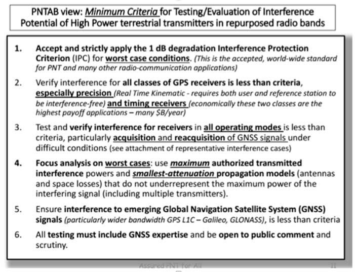
NASCTN’S response did not really address the points, or claimed that there were no funds to correct the problems. The PNTAB then developed a Six-Point Criteria for acceptable interference testing,summarized as:
Accept and strictly apply the 1-dB criterion.
Verify interference for all classes of receivers.
Test and verify for all operating modes.
Focus analysis on worst cases.
Include the new GNSS signals.
Include GNSS expertise and openly publish results.
Image: PNTAB
We believe it is a very reasonable set that aims to protect PNT users and our economic benefits. In its sponsored tests, and in representations to the FCC, Ligado has consistently overlooked a basic facet of radio ranging: it is ranging accuracy, not simply locking onto a signal, that is the fundamental objective for PNT.
Both Ligado test sets clearly failed on all six points.
DOT ABC tests
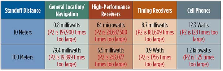
While the Ligado-sponsored tests were neither independent nor adequate, the Department of Transportation, led by Karen VanDyke, sponsored a very complete set of independent tests; these are the most credible estimates of harmful interference. The ABC results have been made public. The PNTAB’s six points were published after DOT testing had begun, but DOT expanded and modified their effort to satisfy the criteria. The DOT conclusions, based on modeling real-world antennas and propagation patterns, are shown in Table 1.
TABLE 1. DOT ABC test results. Maximum tolerable effective radiated power (EIRP) for classes of the most susceptible GPS receivers for modified Ligado proposal (P2) of 1.58 kilowatts. In red are the factors that Ligado P2 exceeds the maximum tolerable radiated power. (Chart: GPS World)
At 100 meters, all classes of receivers tested had results that would exceed the 1-dB threshold, even for the reduced power level (P2, 1580 Watts) that has been the most recent filing. The shaded square is particularly troublesome. It shows that, for the most susceptible high-precision receivers, the Ligado proposed power exceeds the 1-dB threshold by over 200,000. This result is particularly damning for the proposed repurposing, because it is this class that produced the highest payoff in the recent Department of Commerce Study — over $30 billion per year.
PNT operations at risk
These are examples of unintended and potentially hazardous consequences of repurposing.
UAVs. Unmanned aerial vehicles (drones) will fly very close to the dense array of transmitters that Ligado would deploy. They usually require GPS for flight control. Even more important, if we are to monitor them and keep them from collisions, GPS offers the only viable techniques with 3D accuracy and almost 100% availability.
Precision survey. This is routinely used in urban areas for building construction and is a major source of productivity gains. These survey receivers are all high precision and routinely make measurements to better than ¼ inch.
Helicopters. These are found in urban area at all altitudes. They are used for law enforcement, rescue and passenger transportation. GPS is mainly used for general navigation.
Public safety vehicles. Fire, police and ambulances use GPS for both navigation and dispatch tracking. In a city, they would drive in and out of susceptible high-interference zones.
The PNTAB believes the DOT results are representative, accurate and credible. The National Coordinating Office for PNT also sponsored an evaluation of all testing to date. A summary report is now in coordination, as a combined Department of Defense (DOD) and DOT effort.
The DoD, which uses GPS in the national airspace for routine flight, testing, training, guiding rocket launches, and for humanitarian rescue missions, has opposed repurposing. The Air Force reported, “Results from the DOD ABC Assessment support the conclusions drawn from Department of Transportation’s ABC Assessment.”
November PNTAB meeting
At our November meeting, the board invited Ligado to make a presentation on its repurposing proposal. The invitation said: “Specifically describe your implementation plan, with a corresponding test plan addressing the issues we have openly raised. We request you specifically focus on those regarding the potential for interfering with any GPS/GNSS services that operate in the protected space-to-Earth L-band (1559–1610 MHz). Included should be all modes of operation and the use of all current and future GNSS signals.”
Valerie Green, executive vice president and chief legal officer of Ligado Networks, represented Ligado. In the run-up to the meeting, the Six-Point Criteria had been sent to Ligado. Green did not address the six points at all.
She did offer to reduce initial power to “the safe power level in the 1526–1536 MHz channel ranges from 9 to 13 dBW EIRP nationwide,not just near airports.”
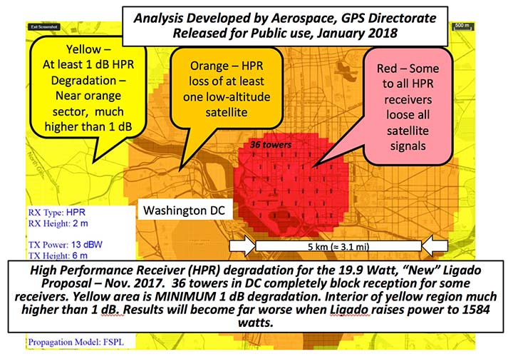
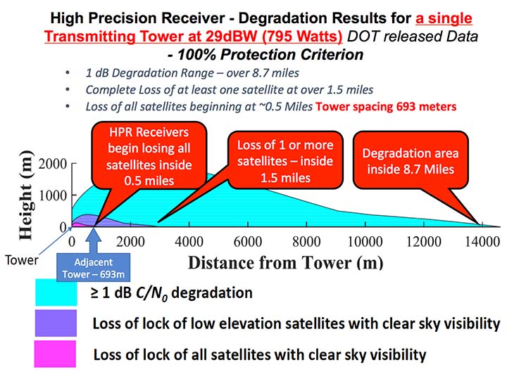
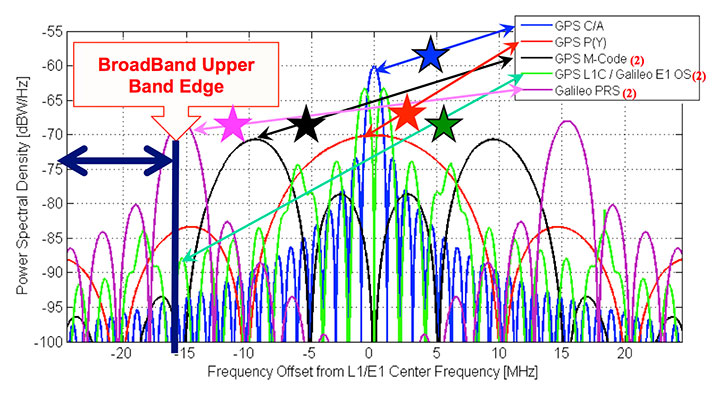
FIGURE 1. Potential impacts on high-performance receivers. Red: loss of lock of all satellites. Yellow: loss of lock of low-elevation satellites. Green: 1-dB degradation. (Chart: PNTAB)
The 13 dBW corresponds to initial power levels of 19.95 W. However, Ligado has made clear in its FCC filings that it ultimately still wants a full 32 dBW base-station transmit power level, consistent with typical 4G/LTE networks.
The initial reduced power sounds like a major move in the right direction, but further questioning revealed two major issues:
Tower Spacing. Green was very evasive on the spacing of transmitter towers. Clearly, at the reduced power level, greater density would be needed to carry the original data bandwidth. At about 1/100th the power, density would have to increase by a factor of 100, and the spacing would have to decrease to 1/10th for the same data output rate.
Green referred us to an earlier filing which specified 0.25 mile, but did not clearly state that this was the plan; she claimed the details were proprietary. If this fundamental parameter, spacing, is not specified, it is hard to see the basis for the FCC evaluation of any new proposal. If the transmitter spacing is reduced to less than 1/10th of a mile, the sources of potential harm would be multiplied in a very worrisome way.
Future power constraint.A public presentation does not ensure that Ligado will actually file and agree to abide by those power constraints indefinitely. Board members pressed Green on the permanence of the power constraint.
She suggested it would be tied to the RTCA Minimum Operational Performance Standard. Revising the MOPS takes many years, if not decades, both to formulate and to implement. Retrofitting the commercial aircraft fleet is very expensive and time-consuming.
Further, her statement focuses only on commercial aircraft, ignoring the high-precision classes as well as future signals.
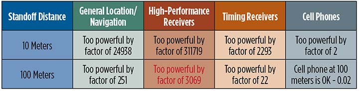
A modified summary chart (Table 2) for the lower power, based on the DOT ABC test results, shows that even at the lower power, the threshold for high-precision receivers is exceeded by a factor of over 3,000 at 100 meters. In fact, only cell phones, which are relatively inaccurate, could operate at 100 meters without exceeding the threshold.
TABLE 2. Results of DOT ABC test with Ligado transmitters constrained to 19.95 Watts (13 dBW). This illustrates that the International Interference Limit is exceeded many times over at 100 meters for certain high-precision receivers, highlighted in red. (Table: GPS World)
With these expectations and uncertainties, the PNTAB did not find the new revision acceptable to the PNT community.
Three fundamental issues
Ligado has steadfastly not accepted the realities of non-interference.
1 dB. Acceptance of the 1-dB (25.8% noise increase) International Interference standard is fundamental to protecting GPS applications throughout the country.
All current and future uses. Users of great concern are emergency services, helicopter and general aviation, UAVs, and precision survey and machine control. For example, many of the underground utilities in the U.S. have been mapped with precision, GPS-based, geographic information receivers. This application requires sub-meter accuracy and operates in both rural and urban environments.
Ligado has tended to simply focus on certified aviation, claiming that protecting that class of user is enough. The PNT community rejects that view. All current and future PNT users must be protected.
Worst–case interference. The recent round of testing was largely in a laboratory. Extrapolating to the real world must examine the situations with greatest interference. For example:
Number of simultaneous interfering transmitters. A single transmitter situation is not typical; three or more are apt to be in range. The additive power must be considered.
Propagation models. Propagation models for communications differ from those for evaluating potential interference to a navigation signal. For assured communication, a typical model assumes transmitted signal fall-off a little faster than 1/(distance squared). Ligado would naturally prefer to use this model, which is far from worst-case for interference. The early round of tests in Las Vegas verified the communications model would vastly underestimate interference levels, by factors of 10 or more. A more realistic model must be used.
Degradation Radius. This is the size of the circle within which the International Standard is violated for receivers in a specified class. If the spacing of transmitters is 400 meters, and the degradation radius is 200 meters, virtually all receivers are in the degradation zone. Ligado suggested an appropriate degradation radius is 250 feet for aviation (approximately 100 meters). Thus, they claim the PNT community should tolerate violation of the standard when closer than 100 meters to their transmitters. At 400 meters spacing, 25% of the area would be in violation.
But the ABC test results reveal a much graver situation. They show that, for the current Ligado proposal (1580 watts), the degradation radius is over 14 kilometers for high-precision receivers. See Figure 2.
The 1-dB criterion is the correct, accepted and somewhat generous allocation of interference that can be accepted by the PNT community. We would hope that the FCC would continue to insist on this standard.
PNT users must, yet again, defend the spectrum vigorously. Most of us are scientific and technical people. We are not used to discussions that deliberately avoid the technical issue or deny scientific evidence. We reject arguments that violate the fundamental laws of physics.
The currently filed proposal, 1580 Watts at spacing of ¼ mile, is unacceptable. It will do grave harm to many important PNT applications
We must be very leery of the new proposal by Ligado of 9–13 dBW. It still would violate the 1-dB criterion at 100 meters for many PNT users.
Moreover, the company history has been to bait and switch; it has an authorization for MSS Ancillary Terrestrial Component (MSS ATC) stations to fill the gaps in satellite coverage with ground transmitters. These must operate in conjunction with the space-to-ground link that made them effectively self-limiting. However, in 2011, it almost succeeded in switching this to a ground-only system, which would have achieved a huge financial windfall.
Open-air verification
If the FCC continues to consider this proposal, there is one step that it should take before granting it. It should require Ligado to deploy an array of transmitters in its advocated configuration, and run real-world, open-sky testing to assess the harm that may result, particularly to high-precision accuracy.
Such testing was done when the issue was first raised in 2011 and conclusively demonstrated unacceptable interference. Nothing has really changed from the baseline that was tested and found unacceptable then.
The company should carry the full financial burden of such a verification, under PNT supervision. The government, having already spent millions of dollars to defend the spectrum, should not bear the cost of such retesting.
Without this confirmation, it is hard to conceive of putting GPS and PNT at significant risk to satisfy investors who want to flip a company, after gaining “rezoning” permission for their spectrum.
From 20,000 feet altitude
If we examine the situation without the technical details, we have this: Fundamentally Ligado wants to provide service using its allocated frequency band for an unlimited number of Internet-of-Things installations.
It is not proposing a small, fixed number of transmitting towers located in isolated regions, but rather an accelerating deployment of private networks, many of which will be close to commercial and essential infrastructure where GPS use is critical.
It seems unrealistic that Ligado can or will reliably guarantee that these widespread installations will be continually adjusted and monitored to avoid GPS interference.
I believe the concept of allowing the installation of transmitting towers that, by design, will interfere with normal GPS use at some distance away opens the door to tacit approval of short-range (or not-so-short-range) GPS jammers.
While I can commend the entrepreneurial spirit, the Ligado proposal seems very reckless indeed. The incremental value of an additional broadband transmitting system when there are at least five already in existence seems trivial compared to the potential damage done to the modern utility named GPS.
I sincerely hope the FCC can find a spectrum swap or deny outright the current Ligado application.
Ligado Networks will appear and present at the National Space-Based Positioning, Navigation and Timing Advisory Board’s (PNTAB) meeting on Nov. 15 in Southern California.
Ligado and its predecessors have sought to install high-powered ground transmitters that have been shown to harm and overwhelm GPS signals and receivers in their general vicinity. The controversy has simmered for at least eight years without resolution.
That final resolution will ultimately be taken by the Federal Communications Commission (FCC), although congressional participation is also conceivable, since national infrastructure security is involved.
Meeting Locale. The PNTAB meeting will take place Wednesday, November 15, 2017, 9:00 a.m. to 5:00 p.m.; and Thursday, Nov. 16, 9 a.m. to 1 p.m., at the Crowne Plaza Redondo Beach & Marina Hotel, 300 North Harbor Drive, Redondo Beach, California, approximately a half hour’s drive south of Los Angeles International Airport. The meeting will be open to the public up to the seating capacity of the room. Visitors will be requested to sign a visitor’s register.
From June 28, 2017, PNTAB presentation by Brad Parkinson.
The central issue in this long-running fight is the as-yet unknown — though uniformly predicted by the various rounds of testing over the last eight years — effects of Ligado signals on a huge installed industrial and governmental base of GPS receivers, some of which are essential to the nation’s critical infrastructure.
Ligado Networks, the current-day incarnation of once-bankrupt LightSquared, seeks FCC permission to apply the satellite-based frequency licenses it owns to be broadcast from a ground-based network. This would put a powerful nearby signal immediately adjacent to the much weaker, more distantly emanating GPS signals, and by the way, those from other GNSS as well. Tests in 2011 and further testing in 2016 demonstrated these powerful signals interfering with GPS receivers.
Brad Parkinson
The Ligado appearance comes in response to an open letter, posted on Oct. 10 by PNTAB First Vice-Chair Brad Parkinson, inviting Ligado CEO Doug Smith to speak to the Advisory Board. That invitation itself emerged after a season of what have been termed “attack” statements issued in various forums by Ligado, which were in turn stimulated by two early-summer letters:
1. A June 27 letter from the American Geophysical Union, Aerospace Industries Association, American Meteorological Society, Aircraft Owners and Pilot s Association, Airlines for America, General Aviation Manufacturers Association, International Air Transport Association, Iridium Communications, Thales USA and other organizations (totaling 22) to the FCC opposing Ligado’s request.
“The undersigned organizations . . . write to reiterate that the threat of harmful interference from Ligado’s proposed ancillary terrestrial component (“ATC”) service remain real and persistent. Contra ry to the assertions in Ligado’s FCC advocacy and recent media blitz, its proposed terrestrial operations continue to pose a significant interference risk to numerous parties . . . . The risks to these critical services are very real and, consistent with the public interest, cannot be brushed aside.
That letter further notes that “Ligado seeks the ability to sell its spectrum to the highest bidder, underscoring the uncertainty of any prospective value of the services it has on previous occasions suggested it may provide. There is a clear effort by Ligado to downplay the significance of the technical concerns it continues to receive from numerous directions.”
2. A July 5 letter from the PNT Advisory Board to Deputy Secretary of Defense Robert O. Work and Deputy Secretary of Transportation Jeffrey A. Rosen, the co-chairs of the National Executive Committee for Space‐based Positioning, strongly opposing the Ligado proposal.
From June 28, 2017, PNTAB presentation by Brad Parkinson.
“The revised [Ligado] proposal to the FCC is fundamentally unchanged from a previous proposal reviewed in 2011. Extensive government testing in 2011 and in 2016, clearly shows that both proposals cause definitive harmful interference to many classes of GPS receivers.”
“All GPS stakeholders should be wary of any incremental approaches to deploying mobile broadband services in the mobile satellite systems (MSS) band. For example, initial services could operate at reduced power levels on a temporary basis to protect only a subset of GPS users, before moving to full — power levels that will cause widespread interference to many other classes of GPS users. Regulatory decisions must be based on the ultimate end-state of any systems proposed for operation in the bands adjacent to GPS, and must protect all classes of GPS users. Unfortunately, the latest industry proposal does not acknowledge the legitimacy of, and the need to protect, dozens of precise applications of great national importance.”
From June 28, 2017, PNTAB presentation by Brad Parkinson.
Round Two. The struggle has been a prolonged one, with many twists and turns, however coalescing into two main periods of activity:
2011-12, when the first round of tests showed then-LightSquared’s proposed network would overload the vast majority of GPS receivers. The Federal Communications Commission (FCC) tabled the proposal, and the company, holding spectrum licenses whose value could range far into the billions of dollars, filed for bankruptcy.
2016–18. LightSquared emerged from Chapter 11 in 2015 as Ligado Networks, positing a modified network plan, but one whose organizing concept remains unchanged, causing deep and continued alarm over GPS interference. 2017 tests, conducted by a firm and a government organization hired by Ligado, essentially reconfirmed the 2011 results. The tests found that the proposed ground towers would significantly interfere with GPS receivers as far away as 4 to 5 kilometers, “killing them dead” in the words of one expert who reviewed the test data.
Parkinson’s October 10 letter invites Ligado CEO Doug Scott “to provide the committee with clear up-to-date design information. . . . How might the system as now envisioned be deployed? How many ground terminals are needed, for example, and where would they be?”
Previous LightSquared and Ligado presentations have been long on promise but short on details. In fact, sound technical underpinning has not been communicated.
From June 28, 2017, PNTAB presentation by Brad Parkinson.
Parkinson writes “we would therefore encourage you to specifically describe your implementation plan , with a corresponding test plan address ing the issues we have openly raised . We request you specifically focus on those regarding the potential for interfering with any GPS /GNSS services that operate in the protected Space – to – Earth L band (1559 – 1610 MHz) . Included should be all modes of operation and the use of all current and future GNSS sign als. Without these specific technical details and corresponding evaluations, we can only conjecture as to what you are really proposing .”
Later, he affirms “our focus is to provide advice based on deep engineering and related expertise . As you know, interference to GPS/GNSS can adversely affect numerous safety – of – life systems , other vital national assets, and applications comprising over $60 billion of annual U.S. productivity benefits .”
Parkinson and the PNTAB have had better luck securing a Ligado appearance than did GPS World magazine. In August of this year, Ligado’s senior vice president and chief engineer for radio access technologies thrice declined an invitation to give a brief Expert Opinion for the September issue on the question: How can the safety, security, and full utility of GNSS applications be ensured while evolving best, most efficient use of limited, very valuable electromagnetic spectrum?
Just a Refresher. The PNTAB meeting will be held Wednesday, November 15, 2017, 9:00 a.m. to 5:00 p.m.; and Thursday, November 16, 2017, 9:00 a.m. to 1:00 p.m., at the Crowne Plaza Redondo Beach & Marina Hotel, 300 North Harbor Drive, Redondo Beach, CA, approximately a half hour’s drive south of Los Angeles International Airport. The meeting will be open to the public up to the seating capacity of the room. Visitors will be requested to sign a visitor’s register.
Ligado is by no means the only item on the Committee’s docket, but is very likely to be the pièce de résistance. The full agenda for the meeting includes:
Update on U.S. Space-Based Positioning, Navigation and Timing (PNT) Policy and Global Positioning System (GPS) modernization.
Prioritize current and planned GPS capabilities and services while assessing future PNT architecture alternatives with a focus on affordability.
Examine methods in which to Protect, Toughen, and Augment (PTA) access to GPS/Global Navigation Satellite Systems (GNSS) services in key domains for multiple user sectors.
Assess economic impacts of GPS/GNSS on the United States and in select international regions, with a consideration towards effects of potential PNT service disruptions if radio spectrum interference is introduced.
Review the potential benefits, perceived vulnerabilities, and any proposed regulatory constraints to accessing foreign Radio Navigation Satellite Service (RNSS) signals in the United States and subsequent impacts on multi-GNSS receiver markets.
Explore opportunities for enhancing the interoperability of GPS with other emerging international GNSS.
Examine emerging trends and requirements for PNT services in U.S. and international fora through PNT Board technical assessments, including back-up services for terrestrial, maritime, aviation, and space users.
Robots are way cool. Anyone three or older knows that. And agricultural robots were among the first envisioned civilian applications of GPS. When Brad Parkinson went to Stanford in 1984, one of the earliest demonstrations he and his bright new students conducted was fully automatic GPS control of farm tractors on a rough field to an accuracy of 2 inches. Now it’s a bazillion global industry. See “Agriculture robots market projected to reach US$5.7 billion by 2024” for a few figures on that.
The market report underpinning that story contained a couple unquantified yet provocative assertions. Here’s one: Rural flight to the cities is a big force in this market’s growth.
“Progress . . . has primarily driven a growing number of people towards the urban areas and the suburbs. . . . This, in turn, has caused a twofold need for the incorporation of agriculture robots in several countries. Firstly, the growing global population — a lot of it being urban — is pressuring countries to increase food production while steadily reducing the hands available for the agriculture industry. Secondly, the overall land slotted for agriculture in nearly all countries is reducing, thanks to the burgeoning industrial sector and residential construction projects.”
I find this a bit chilling, a bit 1984-ish, and goodness knows we’ve got enough of that going on already. Will our future trips through the countryside, the shrinking countryside, take us through landscapes populated by nothing by smoothly chuffing engines? Will the term “bucolic” lose all meaning?
A second factor driving the agricultural robots market is “the increasingly accepted modes of corporate farming.” Now, I know that multitudes must be fed. Still, personally, I buy my food from small, local farmers as much as possible. It simply tastes better. That is indisputable. Arguments rage about whether it’s better for you; I believe that it is.
I hope the small farmers that my family and neighbors depend on benefit from GPS even though they don’t have huge expensive pieces of equipment. I’ll have to ask them next time I go on a visit. Meanwhile if any GPS and/or robotics manufacturers supply products to the artisanal, shall we say, as opposed to the corporate side of farming, I’d like to hear from you.
Locatalite transceiver installation in the White Sands Missile Range Ultra High-Accuracy Reference System, provided by the U.S. Air Force for testing equipment under conditions of GPS jamming.
Provides high-accuracy PNT even when GNSS jammed
A critical capability to predict for GNSS chips and receivers —and for devices using alternative or back-up PNT technologies — is how they will actually perform without GPS.
Filling this need, the U.S. Air Force 746th Test Squadron has declared Initial Operational Capability (IOC) for its new truth reference, the Ultra High-Accuracy Reference System (UHARS) at the White Sands Missile Range in New Mexico. Even when GPS — or any other GNSS system — is being completely jammed, UHARS provides extremely accurate positioning, navigation and time (PNT) over the large area that the system was designed to cover.
“Initial testing shows that UHARS delivers accurate independent PNT as good as, or better than, the Air Force’s current Central Inertial and GPS Test Facility Reference System, so it is perfectly able to support current customer requirements,” said Jim Brewer, chief scientist of the 746th Test Squadron. “However, more data are required to tune the UHARS filter and optimize its accuracy to meet even tighter PNT requirements, which is our objective. When this is achieved, UHARS will deliver truth accuracy for next-generation military capabilities, and we will declare UHARS Full Operational Capability.”
“UHARS is a rack-mounted, tightly integrated system of improved navigation sensors, a data acquisition system and a new post-mission Kalman filter, all of which need to work together,” said John Cao, technical director of the 746th. “It’s working very well, but once we completely measure and characterize the individual components and then tune and validate the filter, the complete system will provide a significantly more accurate reference solution for future airborne and land-based test vehicles in navigation warfare environments where modernized and legacy GPS signals are jammed from friendly or hostile systems.”
LocataLite Transceivers. To achieve these accurate reference solutions, UHARS requires a core Non-GPS Based Positioning System (NGBPS) component capable of operating and providing sub-meter position accuracy in a GPS-denied (jamming) environment.
The NGBPS subsystem of the UHARS program employs a network of ground-based LocataLite transceivers and test vehicle receivers manufactured by the Locata Corporation. The Locata network delivers centimeter-level positioning and navigation as well as nanosecond-level synchronization, which may be useful for military applications requiring precise time transfer in GPS-denied environments.
White Sands is a U.S. Army rocket range of almost 3,200 square miles in parts of five counties in southern New Mexico. It is the largest military installation in the U.S.
The LocataNet truth reference system can also provide a 2D solution to support ground-vehicle testing. Reportedly, the 2D solution, while also very good, has not yet been fully characterized. Once the filter has been fully tuned in this respect, White Sands could serve as a test facility for autonomous driving. It has many miles of paved highway, possibly in the hundreds of miles.
The importance and uniqueness of White Sands as GPS test facility springs from the fact that it is illegal to jam GPS elsewhere without a special permit, making it extremely difficult to create a real-world test scenario to see how GPS and other PNT devices perform under denied or restricted circumstances. This is of critical importance for flight testing (UAVs and other avionics) for which the UHARS was primarily designed and optimized.
Ligado study flawed, says NovAtel
Method shows lack of understanding of GPS uses
NovAtel Inc. has submitted comments to the Federal Communications Commission (FCC) regarding Ligado Networks LLC’s (formerly LightSquared) License Modification Applications.
NovAtel raises deep concerns about the testing methodology used and conclusions presented by Ligado regarding the impact of its proposed usage of L-band frequencies for a terrestrial wireless network.
In its filing, NovAtel identified serious flaws in the testing methodology used to evaluate high-precision receivers. Although high-precision receivers were used during the testing, the high-precision position modes that are used to achieve centimeter-level positioning accuracy required by many professional and safety-critical applications were not evaluated.
The study shows a lack of understanding of the uses of the GPS by assuming that all applications require the same positioning accuracy, NovAtel said.
The filing also raises a number of concerns about the potential harmful interference impact on GPS receiver performance. NovAtel is particularly concerned that Ligado has moved away from what it understood to be an agreed-upon standard that interference tolerance should be limited to a received interference signal power level that causes no more than 1-dB degradation in the received C/N0 level.
NovAtel disagrees with the conclusion in the RAA Study that there is no meaningful correlation between a 1-dB change and GPS performance. NovAtel submits any interference must not exceed 1-dB degradation in received C/N0 if robust, precise positioning is to be maintained. Ligado has not yet proven that its use of the spectrum will not be detrimental to high-precision GNSS users, which is what the 1-dB C/N0 degradation metric ensures.
“To date, Ligado has not proven that its use of the proposed spectrum can be made compatible with high-precision GNSS,” NovAtel said in a press release. “The interference impact on the other GNSS constellations such as Galileo, GLONASS and BeiDou has not been addressed. These constellations are increasingly used in combination with GPS for many high-precision applications. Proposed, unverified mitigation methods such as narrowband antennas are presented in the Ligado filing without explanation of who will be responsible for the cost of such design modifications and retrofit programs.”
Galileo reaches teendom
Europe’s 13th and 14th Galileo satellites lifted off at 08:48 GMT from Europe’s Spaceport in French Guiana atop a Soyuz launcher. (Photo: ESA)
The Galileo constellation system now has 14 satellites in orbit after a May 24 double launch. Birds 13 and 14 lifted off together at 08:48 GMT (10:48 CEST, 05:48 local time) atop a Soyuz rocket from French Guiana. The twin Galileos were deployed into orbit close to 23,522 km altitude, inclined 57.394 degrees to the equator, 3 hours and 48 minutes after liftoff. Following days saw a careful sequence of orbital fine-tuning to bring them to their final working orbit, followed by a testing phase so that they can join the working constellation later this year.
Marconi Prize awarded to Brad Parkinson
The Marconi Society awarded its 2016 Marconi Prize to Bradford Parkinson. The annual prize recognizes major advances in information and communication science that benefit humanity: in this case, the difficult yet ultimately successful development of GPS. See gpsworld.com/marconi for details and a brief history.
The Marconi Society has awarded its 2016 Marconi Prize to Bradford Parkinson. The $100,000 prize, given annually, recognizes major advances in the field of information and communication science which benefit humanity.
Parkinson’s contributions to the development of GPS helped create the vast global utility that provides positioning, navigation, and timing (PNT) information to the world and is a vital part of today’s global information infrastructure. The early stages of GPS were very nearly derailed and the U.S. Air Force might have abandoned its development had it not been forced to fund it. In a historic decision, the Air Force selected a project leader uniquely qualified to make it a success.
A Bit of History. Lt. General Kenneth Schultz, Space and Missile System Office (SAMSO) Commander, called Colonel Parkinson to his office in November, 1972. The General’s purpose was to discuss a floundering USAF program called 621B, which was attempting to create a global navigation service using satellites. Parkinson wasn’t interested. “I already had a super job with a hundred million dollars of play money every year that I could spend on anything related to ballistic missile re-entry,” he recalls. Meanwhile, the incipient GPS program was mired in technical challenges and in competition with other ideas within the Dept. of Defense.
The General insisted. Parkinson, a rising star and perhaps the top military expert on inertial navigation, had one question. If he accepted the assignment, would he be in charge of it? When the General said, “I can’t promise that,” Parkinson said, “Then I don’t volunteer.”
Fortunately, Schultz went ahead anyway. By the time Parkinson was ten feet out the door, the General had called personnel and initiated his transfer — in the process giving the young colonel the authority he had requested. With sinking heart, Parkinson realized he had inherited a lot of good underlying thinking, but so much infighting that the program had ground to a halt.
Parkinson’s career had prepared him for this project, from his study of navigation at the U.S. Naval Academy to his Master of Science study at MIT, at a time when Charles Draper was making his mark on inertial navigation, to his subsequent PhD research at Stanford University. Parkinson had taught future astronauts about satellite design and operations, and he understood navigation from the inside, as a mission commander flying combat sorties in Southeast Asia.
An Amazing Coincidence. In what Parkinson calls “an amazing coincidence,” Dr. Mal Currie, the senior person in the Dept. of Defense for development, had just been appointed and was moving to Washington from Los Angeles. However, he needed to travel back and forth to Los Angeles for several weekends to organize his family’s move. To make it official, he would stop by the Space and Missile Systems Office for a briefing each weekend. General Schultz soon ran out of top-level discussion topics, so someone had the bright idea to send Dr. Currie down to discuss 621B with Parkinson.
“Here I am, a brand new colonel, given uninterrupted time with the senior-most development leader in the whole Defense Department, about five levels above me, and I have all afternoon. He is brilliant; he is a nuclear physicist. We soon got down to technical stuff. I brought out this big stack of charts and a small projector, using the wall as a screen,” Parkinson remembers. By the end of the afternoon, Parkinson had convinced Currie that GPS was a great idea. It just needed tweaking.
With Currie’s support, Parkinson kept plugging. He requested — and got — some of the brightest minds in the Air Force to help him. He encountered opposition everywhere, even veiled threats. Finally, in August of 1973 he stood before a sea of DoD General officers and officials in Washington. He presented GPS as it then stood, for a thumbs up or down vote. It was thumbs down. The Air Force preferred to build more planes.
Currie, who had chaired the meeting, immediately called Parkinson to his office. “You and I know you inherited this program, but there are some improvements you can make. I’d like you to make those improvements and come right back to another decision meeting,” Currie said.
Lonely Halls Meeting. Parkinson gathered a small group of his brightest team members. They met not in Los Angeles, where the group was based, but in the deserted Pentagon, over Labor Day weekend. The only occupants of the largest office building in the world were Parkinson’s band in a 5th floor conference room.
They worked nonstop to change the proposal. The 621B fundamentals were sound, but several technical details had to be modulated to make it the GPS we know today. The team confirmed the use of the then-unique digital signal structure called code-division multiple-access (CDMA) that had been tested by 621B. This allowed the signals used by all the satellites to broadcast on the same frequency and insured that location precision (eventually to millimeters) could be achieved. Equally important, they decided every satellite had to carry redundant atomic clocks, so that signal timing was accurate even when on the other side of the world. Use of such clocks had been advocated by both 621B and the Navy.
They also confirmed the over-all GPS system concept from 621B: the user would measure the range to four satellites, with knowledge of the exact time they broadcast their signal and their location, then the user could triangulate the receiver’s position as well as determine time to nanoseconds. GPS was built on this premise.
Parkinson went back to Currie with his revised proposal in December 1973, and this time received thumbs up. Just 44 months after contract award the Air Force launched the first GPS satellite — probably a record for any military program. Today, 30 operational GPS satellites circle the planet.
After retiring from military service as an Air Force colonel, Parkinson inspired a new generation of GPS scientists at Stanford, where he is a now a professor of aeronautics and astronautics, and other leading engineering schools, helping push hundreds of enhancements and new applications. At his Research Center, he and his allied faculty and students developed the concept and first demonstration of the FAA’s now-operational GPS integrity system, called WAAS. With his students (and sponsored by John Deere) they demonstrated the first GPS auto-guided farm tractor, now an $800 million world-wide GPS farming business. In 1992 they demonstrated the first completely blind landing of a commercial airline (and repeated it for 110 landings!).
“Today, there are billions of GPS receivers in the world,” says Marconi Society Vice Chairman Vint Cerf, “GPS is one of the most under-rated advances in the history of information science. It’s taken for granted, but Parkinson was on the ground floor of enabling air, space and terrestrial guidance and navigation with GPS. His vision for the use of timing signals resulted in cellular telephone improvements, better Internet traffic control, power grid management and a myriad of important financial applications. Dr. Parkinson’s achievements have been game-changing.”
“With immense dedication, Dr. Parkinson overcame technical and bureaucratic obstacles in order to champion the early development, and later enhancement through modernization, of GPS,” said Dr. Charles Elachi, director of the Jet Propulsion Laboratory. “We now take for granted GPS technology, whether our phone is providing turn-by-turn directions or enjoying GPS-time-synchronized communications. However, the concept of using an orbiting spacecraft’s transmitting radio signals as a solution for all-weather global navigation (positioning and timing) faced enormous obstacles during its development phase in the 1970s. As the program director for the Air Force, Dr. Parkinson and his fellow engineers were pushing the state of the art.”
Parkinson will receive the Marconi Prize at a private ceremony at the Computer History Museum in Mountain View, CA, on November 2, 2016. He joins a select group of scientists whose work in communications and information technology has led to major advances and provided social, economic and cultural benefits for humanity. Past winners of the prize, established in 1975 by Gioia Marconi Braga, daughter of Guglielmo Marconi, have included Internet pioneers Vint Cerf, Bob Kahn and Len Kleinrock, digital trailblazers Irwin Jacobs and Henry Samueli, encryption pioneers Ron Rivest, Marty Hellman and Whit Diffie, MIMO inventor A. J. Paulraj and cell phone pioneer Marty Cooper, among others.
GPS World is indebted to Ken Pesyna, a 2015 recipient of the Marconi Society’s Young Scholar award, for bringing this story to our attention. Pesyna co-authored the February 2015 cover story, “Accuracy in the Palm of Your Hand” and is currently CTO and co-founder at Radiosense.
The Marconi Society was established in 1974 through an endowment set up by Gioia Marconi Braga, daughter of Guglielmo Marconi, the Nobel laureate who invented radio (wireless telegraphy). It is best known for the Marconi Prize, awarded annually to an outstanding individual/s whose scope of work and influence emulate the principle of “creativity in service to humanity” that inspired Marconi. Through symposia, conferences, forums and publications, the Marconi Society promotes awareness of major innovations in communication theory, technology and applications with particular attention to understanding how they change and benefit society.
Registration is now open for the International Symposium on GNSS (IS-GNSS 2015), which will be held Nov. 16-19 in Kyoto, Japan. The early bird registration deadline has been extended and closes Aug. 31, and regular registration is Sept. 1-Oct. 31.
The International Symposium on GNSS is designed to bring together experts engaged in PNT and GNSS technologies — including industry professionals, practitioners, academics and researchers — to disseminate their latest research results and allow cross-disciplinary exchange of knowledge to further advance the fields.
Brad Parkinson will deliver the keynote address. Besides keynote addresses, the conference will feature oral presentations, interactive poster sessions, panel sessions, open interactive forums and an informative trade exhibition.
The Asia and Pacific Rim meeting of the CGIC (Civil GPS Service Interface Committee) will be co-located with ISGNSS 2015 to help improve understanding of world trends in developing and deploying GNSS.
Kyoto is the ancient capital of Japan and a top tourist destination, organizers said, with the conference scheduled during the best sightseeing season.
Registration will open April 1, along with a hotel booking page. The logistic information will be announced later.
A student scholarship is being offered to the student with the most promising paper. “If you have students, please encourage them to apply,” said Akio Yasuda, president of Institute of Positioning, Navigation and Timing of Japan.
In May 2011, Dinesh Manandhar and Hideyuki Torimoto of GNSS Technologies, Inc., Japan, penned a very interesting article in GPS World titled – Opening Up Indoors: Japan’s Indoor Messaging System, IMES. The opening paragraph of their lengthy article seemingly describes the Holy Grail for the indoor positioning lobby:
“An indoor messaging system (IMES) has been developed to meet the challenges of indoor and deep indoor positioning, as a system that can be implemented in any device that has a GPS/GNSS receiver without hardware modification. IMES can provide reliable 3D position data with a single transmitter device without performing range calculation[s].”
They go on to describe the IMES concept thusly:
“The main concept of IMES is to transmit position and floor ID of the transmitter with the same RF signal as GPS. IMES transmits latitude, longitude, height, and floor ID by replacing the ephemeris and clock data in the navigation message of GPS. A single unit of IMES is enough to get the position data, since the position itself is directly transmitted.”
Now, you don’t have to be a rocket scientist to start thinking about interference and spoofing issues or risks, especially when you read that the navigation message ephemeris and clock data are being replaced by data broadcast by IMES. To be fair, the authors address these issues briefly:
“Since IMES shares the same frequency as [the] GPS L1 band (1575.42 MHz), there is an interference level that IMES may have on GPS signals. This interference has been studied in detail by conducting experiments and simulations. Based on these studies and analysis, various methods have been considered to avoid harmful interference to GPS signal. To avoid such interference, IMES center frequency is shifted by +/– 8.2 KHz from GPS L1 band. This will have the least impact on the GPS L1 band signal. For example, if the IMES signal is –110 dBm (very strong) and the GPS signal is –142 dBm (very weak), the loss of GPS signal (C/N0) due to IMES is less than 2 db. If the IMES signal is –120 dBm and the GPS signal is –142 dBm, there is no loss of GPS signal (C/N0). Based on this analysis, the IMES transmitter power must be controlled such that the maximum power to the receiver does not exceed –110 dBm at a distance of 3 meters from the transmitter. [There are] guideline[s] specified in the QZSS IS document for setting the transmitter effective isotropic radiated power (EIRP) based on location.”
Let’s put these concerns in perspective. I thoroughly enjoyed the article and firmly believe that we desperately need to solve the indoor positioning and navigation problems, especially for our warfighters and first responders. While many of today’s excellent commercial receivers work well indoors near windows and doors, they are absolutely abysmal underground and deep inside large buildings with lots of metal, or in the middle of dense urban canyons such as Tokyo, Japan. Without a doubt, there is a dire need for a system like IMES — or maybe exactly like IMES — but there must be some caveats and stipulations as to how the IMES system is implemented.
Not Alone
Fortunately, I am far from being a lone wolf in voicing my concerns and my position, for once again the conspiracy theorists as well as renowned scientist and policy makers are concerned about IMES and the operating systems they supposedly desire to replace or augment. Chief among them is the Father of GPS, Dr. Bradford Parkinson, who has frequently described improperly operated in-band pseudolites as “…just another name for a legal jammer or spoofer.” Having known Brad for almost 40 years, I am convinced few GPS experts in the world today have as much experience with pseudolites as Dr. Parkinson. Consequently, the very reason that an indoor navigation system such as IMES is needed may well be a portent for why it may well fail, unless it is implemented properly.
It would be easy but extremely tedious to write about the numerous issues facing IMES in a complicated and technical manner. Certainly previous articles have become bogged down in minutia, and I want to avoid that. It is actually very simple. The issues are fairly straightforward and should be faced head on and not hidden in the midst of tech-speak lingo, legal jargon, policy minutia or politics. So lets dive straight in, shall w,e and make sure these issues see the light of day?
Interference
There can be no doubt that IMES has the potential to significantly interfere with GPS and QZSS signals. The authors of the IMES article are quite clear concerning the potential for interference, and in their own way attempt to mitigate it with signal power restrictions. Their example of a small three- to four-story building with IMES transmitters may indeed be adequate for signal power mitigations, but what happens in Tokyo where tall buildings — skyscrapers if you will — abound? When the Tokyo Skytree skyscraper opened to the public in 2012, it was then listed as the world’s tallest tower and Japan’s biggest new landmark. At over 2,080 feet tall, this is definitely the type of building where one would need an IMES system. With an average of 20 IMES transmitters per floor and weighing in with over 200 floors, we can quickly see that there would be over 4,000 IMES transmitters in this one building alone, all broadcasting simultaneously on or near the center frequency for GPS. Absent stringent regulations and infinite care (the IMES article authors propose that the pseudolite network operator will have the responsibility to continuously monitor each pseudolite and the pseudolite network to prevent interference), and perhaps even with those caveats in place, the GPS L-band noise floor would be such that GPS signals would be incapable of being received.
Now, put 20 such buildings in a ten-block area and the noise floor would be almost incalculable and certainly not predictable. Dr. Parkinson’s fears are realized; your legalized IMES system becomes a distributed network of jammers and/or spoofers. However, technically IMES is currently far from being a legal jammer or spoofer as currently IMES transmitters are not legal to operate in the GPS band at 1559-1610 MHz under the International Telecommunications Union (ITU) Treaty per the International Table of Frequency Allocations of the ITU Radio Regulations. The ITU further states that IMES currently operates on an interfering basis with the co-primary allocations (ARNS/RNSS) in this band, and therefore are in violation of the ITU Treaty. However, Japan’s frequency regulatory agency can develop and implement regulations that allow IMES operations. When this occurs, if not operated within stringent guidelines, IMES could then be considered a legalized jammer or spoofer.
Even the Joint Research Centre of the European Commission, the JRC, states in its Executive Summary on pseudolites that in-band pseudolites pose a significant jamming risk to GNSS receivers. Specifically they state:
Pseudolites or pseudo-satellites are an emerging technology with the potential of enabling satellite navigation indoors. This technology found several applications that are not limited to indoor navigation. Precise landing, emergency services in difficult environments and precise positioning and machine control are few examples where pseudolite technology can be employed.
Despite the great potential of this technology, severe interference problems with existing GNSS services can arise. The problem can be particularly severe when considering non-participating receivers — legacy devices not designed for pseudolite signals. The design of pseudolite signals is thus a complex problem that has to account for market requirements (modifications of existing receivers for enabling the use of pseudolite signals, measurement accuracy, target application), regulatory aspects (frequency bands to be allocated for pseudolite services) and interference problems.
JRC investigates the main aspects to be considered for the design of a pseudolite signal standard minimizing the interference problem without compromising the location capabilities of the system. The focus is on the signal characteristics and topics relevant for the signal design.
Pseudolite or Communications System
The second technical portion of the interference issue revolves around how exactly you define IMES, for when you are dealing with radio regulation agencies semantics matter. Think back to the first paragraph of this article where the IMES authors defined IMES as a messaging system. That certainly sounds like a communications system to me, and others agree. Consequently, the question has been raised and rightfully so: Is IMES a navigation and positioning system, a pseudolite or a communications system? Honestly, to me it sounds like a bit of all three, but if you define it as a communications system, then Japan is seeking to authorize the integration of a communications system with known significant interference issues with GPS signals right in the middle — indeed, potentially on the center frequency of the protected navigation band using terrestrial PRN codes assigned by the U.S. government. If IMES is deemed an indoor pseudolite, then the interference issues are still there. But it is defined as a bonafide PNT system using authorized terrestrial PRN codes. Talk about a bucket of worms!
The issues here are numerous, and they need to be fully addressed to ensure that all those who are potentially affected clearly understand what is being proposed and the risk for the public at large, including who owns responsibility if something goes wrong. I could go on for several pages on this issue alone, but suffice it to say, we do not want to authorize a communications system that is a known and acknowledged GPS interferer right in the middle of the band — or anywhere in the band for that matter. Remember all the issues GPS had in the past several years with a communications system in adjacent bands. So, do we really want a known communications system — or communications system masquerading as a pseudolite, for that matter — with known GPS signal interference issues in the restricted GPS frequency spectrum? The blaringly obvious answer is absolutely not! Yet this is exactly what the IMES authors are proposing not only for Japan, but eventually, if they receive authorization, for other countries around the globe as well. Japan has twice petitioned the U.S. government to make the assigned IMES terrestrial PRN code allocations global in nature. Fortunately, to date those request have been denied.
Dichotomy
Certainly, other countries and companies have noticed this apparent frequency authorization dichotomy and are following suit. For instance the Conference of European Postal and Telecommunications agencies, or CEPT, which is Europe’s regional representative to the World Radiocommunication Conference (WRC), has proposed adding several troubling IMES-related agenda items for the quadrennial WRCs coming up in 2015 and 2019. Even more importantly, these critical issues could be aired in the next three weeks, as the agenda for the 2015 WRC will be largely set at a plenipotentiary conference happening October 20 through November 8 in Busan, South Korea.
There are what I consider to be dangerous proposals under consideration by the ITU (International Telecommunication Union), which should concern GNSS users worldwide. The ITU is the United Nations’ specialized agency for information and communication technologies — ICTs. This is the ITU, where every member state (currently 193) gets one vote, whether they fully understand the technical issues or not and regardless of whether they are a space-faring nation or have a dog in the fight, so to speak. This means that the vote of tiny Saint Lucia counts the same as the United States or Canada or Australia. The ITU charter is to “…allocate global radio spectrum and satellite orbits, develop the technical standards that ensure networks and technologies seamlessly interconnect, and strive to improve access to ICTs to underserved communities worldwide.” Fortunately, the ITU regulations, unlike the CEPT or IMES proposals, wisely require new transmitters proposing to operate in the radio navigation spectrum to operate without causing interference to primary users. Meanwhile, there are member states, countries and companies that want to capitalize on this seeming dichotomy within the global safety-of-life, historically protected, radio bands. Those nefarious efforts, for the future of GPS and GNSS worldwide, need to be stopped in their tracks.
Spectrum is a limited and valuable resource, to say the least, and here fortunately the ITU regulations have it right and do not risk human life, by intruding and potentially interfering with the frequencies used globally by airliners to control, route and land aircraft. I am convinced there are solutions available to us through cooperative efforts with the ITU and other national organizations that will produce pseudolites without causing interference in the protected safety-of-life frequency bands.
When Is a PRN Code Not a PRN Code?
Some of you who are a bit more savvy or have been following this fiasco for some time may now be thinking, what’s the problem, the IMES authors are merely using and proposing further use of U.S. government-authorized terrestrial PRN codes for IMES. This indeed touches on the third thorny issue, which is not only technical but political as well — the use of and authorization to use PRN codes for what is ostensibly a communications system, if you believe the authors of the IMES article, who go to great lengths to differentiate IMES from pseudolites. They continually make the argument that IMES is not a pseudolite, but as we shall soon see, when the U.S. government authorized these specific PRN codes (173-182) for Japan, they were to be used solely for a low-power terrestrial pseudolite program, not an in-band communications system.
Technically, these specific PRN codes assigned to the Japanese for IMES expire in 2017. The authorization of these PRN codes come with numerous restrictions that legally make the codes useful only for the Japanese landmass. This is where the technical, political and operational issues come to a head. We are in for some tough sledding here. However, I will endeavor to make it as simple as possible.
History
In 2007, ten PRN codes were specifically assigned to the Japan Aerospace Exploration Agency or JAXA “for the Indoor Messaging System (IMES) terrestrial pseudolites of the Quasi-Zenith Satellite System (QZSS).” The Memorandum of Agreement from the GPS Wing at SMC (Space and Missile Systems Center) in Los Angeles at Los Angeles Air Force Base (LAAFB) clearly states that the codes are valid for ten years and expire on 19 November 2017, unless a renewal application is filed and approved. Hence, PRN codes 173-182 for IMES were assigned with several crucial caveats and restrictions by the U.S. government that are definitely pertinent to our discussion:
The codes are designated for low-power terrestrial regional applications limited to Japan only.
Although the GPS Wing conducts an initial check on PRN number requests with respect to potential interference issues, the issuance of a PRN number does not convey authority to radiate in the [GPS] band. In order to radiate in the GPS L1 band, the applicant [Japan] shall obtain a frequency assignment from the [Japanese] national authority.
The GPS Wing assumes no responsibility for ensuring systems using these spreading codes follow domestic radio frequency regulations or other applicable laws or regulations, or for ensuring that systems using GPS PRN codes do not cause radio frequency interference.
GPS PRN codes were developed for signals transmitted from satellites, and are not necessarily optimized for use by terrestrial transmitters.
The maximum effective isotropic power for each terrestrial transmitter will be less than -94 dBW.
The QZSS [organization] is responsible for the redistribution of these spreading codes throughout Japan and will limit their use to Japan only.
With all these restrictions, it is difficult to see how the IMES authors could legally use, distribute or promote authorization of IMES and the use of the PRN codes outside of Japan and at the power levels related in the GPS World IMES article. Regardless of the IMES author’s interpretation of the PRN code assignment, the GPS Wing 2007 Memorandum restrictions and caveats are clear, and it cannot be disputed that the codes expire in 2017 unless renewed by the USAF. The PRN codes are restricted to the landmass of Japan even if they are renewed, and if IMES wishes to broadcast anywhere in the GPS band, they need to have permission from their national frequency allocation authority (the Ministry of Internal Affairs and Communications, which is equivalent to the U.S. FCC –Federal Communications Commission) to do so.
The Way Ahead
This is the easy part from my perspective. See if you don’t agree. If the U.S. government is concerned about IMES and what Japan is planning to do with the assigned PRN codes for terrestrial use, the U.S. government through the USAF has the options to:
Rescind the PRN codes immediately.
Insure the Japanese adhere to the caveats and restrictions in the original Memorandum.
Simply refuse to renew or recertify the codes for future use and/or recommend for IMES frequencies that are outside the protected GPS band.
Update and clarify the footnote on the GPS Wing PRN Codes website pertaining to the Japanese IMES PRN Codes with all the restrictions listed in the GPS Wing Memorandum so other countries will realize this is not a global IMES PRN assignment.
Japan is a valuable ally and we need to work together cooperatively, but frankly, the plans laid out for IMES by the authors in the GPS World article must be troubling to those whose job it is protect the GPS spectrum and enforce mutual agreements with our allies. If we were just concerned about a Japanese IMES system, this whole discussion might be moot. However, other countries and commercial companies around the world are watching closely and laying the groundwork for similar IMES and pseudolite incursions into the GPS L-band spectrum — if the Japanese are allowed to proceed and the limited use of PRN codes for IMES is not clarified for all. No one, and I include the Japanese, wants to see this happen if it means interference with GPS, and QZSS for that matter.
Fortunately, where European countries are concerned, there are the ITU regulations. Specifically for GPS and pseudolites, the CEPT regulation has a license condition that requires the pseudolite network operator to submit to the European country regulator confirmation of the terrestrial PRN codes from the GNSS operator before operating pseudolites in the GPS band. So again, the U.S. government wields the hammer here.
Therefore, the U.S. government must act immediately and decisively to put an end to the threats against the protected GPS spectrum caused by the proposed in-band IMES system. At the same time, the Japanese government has an obligation and responsibility to adhere to the letter of the law where the original GPS Wing 2007 IMES Memorandum is concerned.
Finally, the U.S. government must urgently engage cooperatively with the European Union administration and Japan to prevent the authorization and proliferation of interfering devices in the GNSS frequency bands, and to work together to ensure the positive benefits to GNSS from commercializing pseudolite uses outside the GNSS radio frequency bands. GNSS manufacturers worldwide are successfully marketing commercial pseudolites that do not cause interference. In my opinion, this is the way to go both in terms of regulations and governance.
Until next time, happy navigating, and remember GPS is brought to you free of charge by the United States Air Force.
Actions Necessary to Reduce Vulnerability and Ensure Availability
By Brad Parkinson
(From the 25th Anniversary GNSS History Special Supplement)
Introduction
Brad Parkinson
About 40 years ago, we had a vision for positioning, navigation, and timing (PNT). That vision was more than successful, and became known as GPS. In some respects we have been almost too successful: PNT is frequently taken for granted. PNT, in the form of GPS, has become a powerful worldwide enabler for productivity and for safety. Estimated yearly value runs to many tens of billions of dollars.
For several years, I have been concerned about comments that denigrate GPS because the signal strength is relatively weak. The speakers have gone on to say it can be completely replaced with inertial or other techniques. Recently, comments by government officials further energized me to look at the full picture.
What can we do to reduce the vulnerability and ensure that the expectations of the users are going to be met? I summarize my solution as the PTA program and will elaborate in this article. At a top level, the term PTA means: Protect, Toughen, and Augment GPS to assure PNT. Note I say PNT, not GPS. The central issue is assuring access of PNT to the user, not the source of the information. I strongly believe that PTA is both achievable and absolutely necessary. Protecting PNT is particularly important to Europeans as they are just about to launch their fledgling Galileo system.
Speeches and travel only reach a limited number. When GPS World invited me to write a piece for the magazine’s 25th anniversary issue, it seemed an ideal opportunity to expand knowledge of the PTA program. The following is an edited form of a talk I have given a number of times, most recently at the European Navigation Conference in Rotterdam in April 2014.
GNSS initiatives and the GNSS community are growing rapidly, and certainly we are very enthusiastic about the progress of Galileo. But some places in the U.S. community are saying, “Well, this GPS band is underutilized; devoting all that bandwidth to a single system is not prudent.”
I beg to differ with that view. If you look at the separate signals in the L1 band around the world, by the year 2023 they will grow to be well more than 400 individual signals. Those signals service over 2 billion users, from emergency service providers to precision agriculture to crustal monitoring and many, many more. I have an entirely separate talk on “GPS for Humanity,” but that is not our subject today.
Calling the GPS frequency band “underutilized” simply points out ignorance, even among our supporters. For example, we say PNT to emphasize that GNSS provides four dimensions. Certainly, timing is the forgotten fourth dimension of GPS, and even our politician friends rarely understand the importance of this aspect. Yet we know that highly accurate timing, supplied by GPS, is absolutely critical for power distribution, for telecommunications, and for the financial sector.
It is instructive to summarize the penetration of the PNT “Stealth Utility” into the fabric of our society.
Market Size. Overall, GPS has more than 2 billion users worldwide. This represents a very diverse user group; we providers are continually seeing new and innovative ways to use GPS.
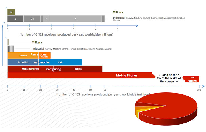
Figure 1, for which I am indebted to Frank van Diggelen, gives an estimate of the number of receivers currently fielded. Notice the number of military receivers: less than half a million. The gray bar depicts the industrial uses such as survey and machine control, which come in at about 4.5 million; these tend to be extremely high enhancers of industrial productivity.
Figure 1. GNSS market size, 2012.
We have to change the chart scale to depict bigger market segments. For example, recreation, automotive, and computing are shown on the lower half of the chart. In fact, mobile phones will still not fit on the chart. Attesting to the size of the estimated mobile phone base: one company alone will produce more than 900 million GPS-equipped smartphones this year. The pie diagram shows the dominance of mobile devices, but much higher productivity gains come from high-precision devices whose impact is very disproportionate to numbers of receivers.
We asked some economists, just what is all this worth? They looked at a subset of all the industries and concluded that GPS has a positive net effect to the tune of at least $32 billion annually. They had an expanded study that suggested about $90 billion annually. So, for those who question the value of GPS, the answer is that the net yearly returns to our national investment are more than 1000 percent. (Note: National investment is about $3 billion annually.)
To ensure these enormous economic benefits of PNT, there are two fundamental needs, and we providers must assure that they are met. The first and most important need is availability.
Availability. When we say availability, it is defined in a certain way; it means that PNT is available at the application-specified accuracy. We usually measure that accuracy at the 90th percentile: only 10 percent of the time can that error be exceeded.
Integrity. The second user need is the required integrity. That means that when the user expects a specific accuracy, the system is not lying to him. Integrity assurance is very much a focus of both the International Civil Aviation Organization (ICAO) and, in the United States, the Federal Aviation Administration (FAA). In many cases they require that PNT errors not exceed specified bounds more than once in 10 billion measurements (1 x 10⁻⁷). This integrity level requires so many samples, it is virtually impossible to verify experimentally; we have not had that many airplane landings, but it can be calculated. The metric we use is how many minutes GPS is not available — unavailability — at the specified accuracy and integrity. That is more easily understood than availability that aproaches 99.9XXX percent. The usual goal is that unavailability be zero.
We have an independent assessment of how well we are doing: FAA’s Wide Area Augmentation System (WAAS). They put out a report card with a lot of numbers. GPS clearly deserves a grade of A+.
And it will get better. The U.S. government’s PNT Advisory Board, which I co-chair, recently advocated that the full navigation message be added at the new civil frequencies, the L2C and L5C signals. The Air Force has now complied, thanks to strong support from General Willie Shelton. This makes two more civil signals fully available. They currently expect 2.9 meter ranging accuracy, but by the end of the year the Air Force operators expect the same full accuracy as the rest of the signals, on the order of 0.5 meter of ranging error.
This is an outstanding picture.
So What’s the Problem? A statement made by a high-level U.S. government official in my presence exemplifies the problem: “GPS is much too vulnerable. We must replace it with new inertials and chip-scale atomic clocks.”
I found this statement appalling. Unfortunately, it was a meeting where you don’t normally speak up, and I didn’t. Nonetheless, to me, that was totally wrong.
GPS indeed has a very weak signal, and it depends on having clear line-of-sight to four satellites. But in my opinion, a much better statement is what I call the PTA solution. Our goal should be to:
Protect the system and the signal.
Toughen the receiver and the system.
Augment GPS as needed to ensure users’ PNT requirements are met.
The focus is ensuring positioning, navigation, and timing (PNT), not merely ensuring GPS.
Fundamental Prerequisites for PNT
The first prerequisite for GPS-based PNT is a receivable, clear, and truthful(truthful implies full integrity) ranging signal. There are five main challenges to this.
Too-powerful authorized signalsnearby. This aspect snuck up on our community. The FCC authorizers were about to license a powerful signal in the frequency band adjacent to GPS, drowning out any hope of receiving the GPS signal. This can be called the authorized jammer. All PNT providers must be very vigilant about this; we have seen ignorant elements of the government poised to do great harm with well-intended but destructive actions, without knowledge of the unintended consequences.
Natural Interference. This interference, the cause of delays and attenuation, is reasonably well understood, and the subject of much research, dating back to when we first defined GPS. Random events such as solar flares can potentially cause great harm.
Inadvertent Natural or Manmade Jamming. A nearby device that creates spurious, destructive emissions can be a serious problem for GPS receivers. This class tends to be manageable by well-designed receivers.
Collateral Interference. An example is a person who wants to evade tracking but is inadvertently jamming nearby GNSS receivers in addition to his own local receiver.
Deliberate Jamming or Spoofing. This is perhaps the major concern for developers and users. I will discuss this further later.
There is a second major prerequisite: satellite geometry. The user who cannot see enough of the sky is called “sky-impaired.” There are two possible underlying problems:
The satellite constellation has “brown-out” because of failures or inadequate numbers; or
The user is operating in a mountainous or urban area with high, local shading angles.
Overcoming sky-impairment requires a denser constellation, or use of multiple GNSS.
Protect, Toughen, Augment
What can we — as developers, operators, and manufacturers — do to overcome the PNT availability challenges for our users? My solution is PTA. The good news is that quite a few of the actions I recommend are underway — in fact, many of GPS World’s readers are active participants.
I am going to examine these three PTA principles, expand on them a bit, and hopefully explain a few things that help focus on a broad solution.
Protect the System and the Signal
This can be organized into seven actions: three PreActions and four ReActions. PreActions are before there is serious interference, and ReActions obviously come after interference is occurring.
First, the PreActions.
Protect the Spectrum. The chart in Figure 2 represents the frequency plan for the L1 band, and displays some of the sources of the 400 signals I referenced earlier. The blue star, GPS L1 C/ A, is the only fully operational and reliable signal in the world right now. The red star is the U.S. GPS military signal. You can see it has important power lobes close to the band edge. The black star is M-code, the new military signal of the United States.
Figure 2. Frequency plan for the L1 band.
The Galileo power curve, which is pale green, has very significant nodes close to the band edge. Of course, the Galileo PRS (the magenta star) is right on the band edge. The imperative for these wider bandwidths is that they produce sharper correlation edges and consequently produce greater measurement precision. This leads to greater accuracy, and greater usefulness and utility for many PNT users.
Reallocation of radio bands adjacent to GNSS poses a significant threat. The band edge of the proposed high-power communication signal (sometimes called broadband) appears as the black vertical line. It is obviously very close to the edges of many of the colored PNT signals. Tests conclusively demonstrated unacceptable levels of interference with L1 C/A.
Consider the proposed, high-powered terrestrial signal one quarter-mile from a GPS receiver. This produces a power ratio of 5 billion (broadband) to one (GPS). To visualize that power ratio, consider Niagara Falls, which produces about a billion watts. Compared to that, GPS power is a tablespoon of water dropped from five feet, once per second (about 0.2 watts). This is the power ratio that was almost authorized with 40,000 ground-based transmitters in the U.S. At a city block away, the effect is 10 times worse.
To quantify interference effects, some initial tests were run and measured broadband effects used for analysis. Cell-tower locations near Las Vegas, Nevada, approximated the broadband transmitter locations. The nearby airport, McCarran Field, has three RNAV (GPS) approaches. As expected, GPS users on the ground would be significantly jammed, but the effect on aircraft would be nine times worse than the impact on ground receivers. This is due to altitude (line of sight), geometry, and the sensitivity of aircraft receivers.
The 12 broadband transmitters around McCarran Field would jam all of the RNAV GPS approaches to all three runways. Signals of this type would effectively shut down or severely limit operations at the airport.
Signals in the GPS band will increase in the next decade as the newer GNSS become operational. The proposed, adjacent broadband is even more incompatible with these newer signals since they will be closer in frequency. Note that the whole approach was rejected, solely on the basis of L1/CA. It was not even tested against the other, more susceptible, modern signals. The worst would have been yet to come, had they been authorized to broadcast in the adjacent band.
Adjacent bands can continue to broadcast non-GNSS signals originating in space because the power levels will be comparable with the PNT spectrum. But we must be very vigilant to stop any high-power terrestrial signals from being allowed. They would become, effectively, authorized jammers. There should be no spectrum reallocation to ground transmitters until technology has been thoroughly demonstrated to solve any problems, (particularly for the high-precision users) and there is enough time to re-equip the users.
Europeans should have two other important frequency authorization concerns. First, there is a legal barrier within the United States to using Galileo signals. They have not been formally authorized. I think it is a bureaucratic glitch, but it is something we in the United States have to solve; we do want to use all GNSS signals. Stay tuned!
There is another concern. A group at the Electronic Communications Committee, European Commission, recommends allowing pseudolites in the L1 GNSS band. As an experienced user of pseudolites for aircraft landing and some other applications, I believe this is a very risky idea; pseudolites can be very useful, but frequencies should be found elsewhere to avoid unexpected interference.
Stiff Legal Penalties for Interference. The second PreAction is to enact stiff legal penalties for GPS jamming, both in terms of jail time and fines. The goal is to deter the ubiquitous $33 GPS jammer that one can buy on the Internet.
On the U.S. FCC website, the agency lists the penalties for having a GPS jammer. Forfeitures range up to $16,000, and they might even put you in jail. The Australians take a much stronger view: up to five years imprisonment or $850,000 in some cases. Some people are alarmed by these heavy penalties and call them brutal. However, they are not always imposed, and if jamming and spoofing is intentional, especially where the landing of airplanes is concerned and lives are at stake, I think a strong deterrent is warranted.
Stop Jammer Manufacturing, Sales. The third pre-action is to prevent proliferation by shutting down manufacturing and web sales of jammers. What is the status?
The FCC website states that manufacturers should comply with the law: stop marketing these devices in the United States and stop selling and shipping to addresses in the United States. The loophole is you apparently can manufacture these devices if you sell them outside the U.S. Now, I have a little difficulty with this. I have pointed this out to the DHS and others; hopefully, stronger action will be taken.
The FCC told me in an open meeting a few months ago that they were shutting down the websites where these devices are sold. But about three weeks ago, I went online and immediately found a website that sells nine different devices to jam GPS and cellphone devices. Indeed, there were jammers, all very affordable, for jamming just about everything. More recently, the FCC assessed a multi-million dollar penalty against such a jammer manufacturer. We will see if this actually happens. I hope they accelerate these efforts.
Now for the ReActions.
Detect Jamming. To stop jamming, the first step is to know when it is occurring. There are a variety of ways to do this. Some devices or concepts are already on the table: for example, a Chronos CTL3510 GPS Jammer Detector, an Exelis Signal Sentry Jammer Detector, and the J911 cell phone detection and reporting of jamming, an example from NavSys.
The idea behind the NavSys J911 is that all GPS-equipped smartphones have the capability to detect jamming. This does not pinpoint jammer location, but alerts authorities to the problem. Phone location can be reported to a central database for the next two actions.
Pinpoint Jammer Location. Techniques range from directional antennas to time-difference-of-arrival using Fast Fourier Transforms. The latter was demonstrated for the FAA at Stanford more than 10 years ago: location pinpointed within five meters. Cell towers could implement such techniques, since they have accurate time and could run correlations. There are already commercial GPS jamming locators: something called a JLOC (NaySys Jammer Locator). The British are using similar techniques for jammer detection on some of their freeways.
Eliminate Jammer. Having pinpointed the jammer, the next step is to physically eliminate it. What is the status? At Newark Airport there is an FAA, ground-based GPS augmentation system antenna right next to the turnpike. They are part of a blind landing system. In early 2010, there was an infamous jammer interfering with the FAA GPS receiver. It took three months to locate the offending truck driver and shut down the jammer. The good news is that, more recently, in the same general location, they located a similar moving jammer within 24 hours after the interference started. However, these are very special locations. Recent studies have suggested that interference sources are much more widespread. Note: Only certain enforcement personnel are authorized to seize the jammer and arrest its operator.
Prosecute. Having located the offender, the law should then be applied to prosecute. Leeway should be applied, commensurate with the circumstances. In this New Jersey case, the authorities say the perpetrator is liable for a forfeiture of $31,875.
Toughen Receivers
There are at least five well-known ways to toughen receivers, thereby increasing jam resistance:
Increased satellite signal spreading (such as L1C, L5) allowing greater processing gain;
Integration with inertial navigation components;
Digital beam-steering or null-steering antennas;
Increased satellite power such as L5 (a difficult and fairly expensive technique);
Local antenna shading, for example, the top of an airplane, which is shaded from the jammer.
These improvements cascade and are cumulative, but a remaining issue is to make such techniques more affordable.
To illustrate these anti-jamming techniques, consider the effective area of a 1-kW jammer located on the Capitol building in Washington, D.C. A basic high-quality GPS receiver, within a line-of-sight range of 20 miles, will stop providing PNT. Simply using the newest L1C spread-spectrum GPS signal reduces the jamming area by about two thirds, allowing operation to about 10 miles from the Capitol. Adding inertial aiding allows PNT to within three miles, and adding digital beam-forming antennas and using aircraft natural shading brings the effective radius to about 0.1 mile, about the size of the capital building.
The point is toughening the PNT receiver with the technologies mentioned is an extremely effective strategy. It would require over 60,000 jammers to cover the same area as the original non-toughened GNSS receiver.
Some techniques are very affordable today, while others, such as digital beam-forming antennas, remain too expensive for the ordinary user. In addition, there is a potential U.S. problem of export restrictions. Unfortunately, many of these existing restrictions have simply incentivized non-U.S. development of equivalent capabilities.
Augment
The last element of the PTA construct is to augment or substitute PNT sources. We are all aware of the coming revolution in multiple PNT sources from new GNSS. An all-GNSS receiver diversifies the frequencies and the signals, thereby reducing vulnerability to interference. It also improves availability for the sky-impaired user because of densification of satellites sources. Using satellites from multiple constellations can significantly improve availability, provided integrity requirements are met.
With these additional GNSS constellations, there are three major levels of cooperation:
Compatible: no mutal interference;
Interoperable: working to allow common time and geodesy system;
Interchangeable: using accurately calibrated biases and offset. Any four SVs will suffice.
The major issue again is probably integrity, because to ensure economic value, availability requires known integrity. As far as the U.S. FAA and ICAO are concerned, for precision aircraft operations the integrity value should be that the system be “out of spec” less than once in 1 billion times. To be productive they also would like zero minutes of unavailability. That may seem extreme, but commercial aviation and public safety demand it. Regarding integrity, some new GNSS are clearly making faster progress than others.
It is useful to further examine the densifying opportunity of additional GNSS. The chart in Figure 3shows how densification can impact the user. The number of satellites (SVs) available in the sky (assumed optimal distribution) is shown. The colors refer to whether 0, 1, or 2 SVs are out of commission for maintenance or repositioning (typical maximum is 1 for GPS). The measure of effectiveness is minutes of outage per day. Consider a shading angle of 60 degrees, representing a user near a rugged mountain slope area or a city. With the nominal 24 SV GPS constellation (the GPS specification is 24 despite the U.S. having 31 active SVs), the outages, due to geometry alone, are six to ten hours. Improvement with additional satellites is dramatic and quite non-linear. With 33 satellites (about a 37% increase in density) outages are zero minutes per day to 33 minutes if one satellite is out for maintenance (reduction by a factor of over 10!). Of course, SVs could be from different GNSS constellations if they are truly interchangeable and have the required integrity. The clear message is that about 33 SVs are needed to cover reasonably high elevation angles.
Figure 3. How densification of additional GNSS can affect the user.
Integrity Monitoring. Currently, the U.S. GPS control segment continuously monitors GPS satellites. If a fault is found, they set the satellite inoperative until the problem is resolved, which may take many minutes. This alarm time is not fast enough for precision aircraft landing and approach (the requirement is six seconds to alarm). For these rapid integrity alarms, the United States relies on the FAA’s WAAS, and Europe uses EGNOS to monitor the basic GPS L1 C/A signal. Soon, the EGNOS message will include Galileo integrity alerts. Unfortunately, the United States does not yet have a plan for reciprocal WAAS monitoring of Galileo signals. In fact, formal approval to even use these signals has not yet been granted by the U.S. FCC.
Self Integrity (RAIM). If an all-GNSS receiver has more than six satellites in view, the user can use the Receiver Autonomous Integrity Monitoring (RAIM) technique. This allows the user to cross-check each measurement against others to find erroneous satellites and guard against spoofing. Take the recent GLONASS situation. With a good RAIM PNT receiver, the user could quickly isolate the large errors from the combined set of GPS/GLONASS measurements. In fact, some deployed receivers did just that. If all GNSS are totally interchangeable, it will be enormously helpful to implement RAIM.
The recent, prolonged GLONASS outage saddened us all because it reduced the credibility of all GNSSs. We hope the Russians will be forthcoming in announcing what happened and the corrections that are being made; hopefully, it won’t happen again.
Fortunately, there is a third independent, real-time tracking network of 200+ sites, known as the Global Differential System (GDGPS). Although NASA administers GDGPS, local-country scientists maintain and operate individual sites in near real time. GPS is monitored down to centimeter precision.
A central issue for GDGPS is whether the integrity monitor capability itself has integrity. Because of redundancy and independence, a form of inverse RAIM, hereby named System Autonomous Integrity Monitoring (SAIM), can be used. Figure 4 depicts the number of independent looks or ranging measurements to a single satellite over various points on the Earth. You can see in the dark areas the value is 60, and even in the relatively unmonitored areas around South America, the redundancy is 20. At a typical spot, perhaps off Spain, it depicts 50-fold redundancy. By cross-checking the dozens of GDGPS measurements for each satellite, a strong integrity cross-check can be created. The GDGPS plan is to also monitor Galileo as it becomes operational. Thus, GDGPS has excellent prospects to provide real-time integrity assessments for all users and all operational constellations. We need plans to connect all users to these potential integrity alarms.
Figure 4. The number of independent looks or ranging measurements to a single satellite over various points on the Earth.
There are three classes of ground-based augmentations:
Pseudolites. Ground augmentations could also include pseudolites broadcasting GPS-like signals for additional ranging. While somewhat helpful, this technique cannot cover large areas and can act as a strong interference source if the signal is in any GNSS frequency band. For this reason, in my opinion, pseudolites should never be authorized in GNSS frequencies.
Distance-Measuring Equipment. Modernized DME, planned as a GPS supplement by the U.S. FAA, is very valuable for the airborne users. Most ground users derive no benefit from DME because they do not have line of sight to the widely scattered transmitters. Ohio University’s Frank van Gras is working for the FAA on a DME plan should GPS not be available. It involves moving from the so-called legacy DME to the enhanced DME to ensure continuous aviation operations.
eLoran. eLoran, covering expandable local regions, uses a powerful signal at an entirely different frequency. It is two-dimensional, but in calibrated areas differential (eDLoran) is perhaps as accurate as 10 meters for harbor areas and similar purposes.
I chaired a study of eLoran for the FAA in 2006. Initially skeptical, the study members finally concluded (unanimously) that eLoran:
meets the needs of all identified critical applications: 10–20 meter navigation accuracy for harbor entrance; 0.3 mile required navigation performance (RNP 0.3); stratum 1 frequency precision and 50-ns time accuracy.
is a modern system: new infrastructure, solid state transmitters, state-of-the-art time and frequency equipment, uninterruptible power supplies; new operating concepts, time of transmission, all-in-view signals, message channel with differential corrections, integrity; new digital user equipment, processes eLoran and GPS signals interchangeably, compact H-field antennas eliminate p-static.
is affordable: Less than $143M to fully complete eLoran, avoid costs of decommissioning existing Loran-C infrastructure; operations and maintenance currently $37M/year, reduced with eLoran-enabled automation.
And our group concluded it was the most prudent and cost-effective general augmentation or backup to GPS.
The National PNT Advisory Board also unanimously recommended that we deploy eLoran. The departments of Transportation and Homeland Security supported it; then, after a change of administrations, in a budget crunch, it was defunded, and the dismantling of existing Loran C stations began. Congress now may be taking action, and the recent GLONASS outages should give an impetus to that.
Who Will Implement PTA?
To my knowledge, many elements are currently being pursued, some by GPS World readers. But I can identify no entity that has the authority, the knowledge, the breadth, and the resources to create a single, well-focused program. This reminds me of a fable from Aesop regarding ants. When no leadership emerges, the ants have to band together to solve the problem. Yes, I am suggesting that we are the ants and we all must contribute to the solution, as well as seeking governmental agencies to step up to the responsibility.
In that regard I have a “to do” list. We must:
Protect PNT.
Vigorously defend the spectrum.
Work with lawmakers to increase legal penalties for PNT interference.
Work with manufacturers and law enforcement to improve timeliness and accuracy of interference identification (crowd-sourcing, every cell phone a detector).
Field jammer location equipment.
Toughen PNT.
Develop industry (ICAO/RTCA/RTCM) standards for deep inertial integration and directional antennas.
Develop vector receivers (all GNSS).
Continue to implement ARAIM and inertial for integrity (+WAAS/EGNOS).
Encourage users to move to rugged receivers.
Augment PNT.
Expand integrity notifications to include GDGPS.
Develop RTCA standards for seamless DME and GPS/GNSS.
Implement eLoran and develop RTCM standards for seamless use.
Develop an international process for integrity certification of all GNSS (GLONASS, Galileo, and BeiDou).
In conclusion, the rumors of the death of GPS, in my opinion, are greatly exaggerated. Let’s not throw out the baby with the bath water. Instead let’s accelerate and expand PTA to Protect our band, and Toughen our receivers, and Augment GPS to ensure that PNT is available for all users now and in the future.
In the words of American poet Robert Frost,
The woods are lovely, dark and deep,
But we have promises to keep,
And miles to go before we sleep,
And miles to go before we sleep.
Thank you.
BRAD PARKINSON has been the Edward C. Wells Endowed Chair (emeritus) at Stanford University, where he is a recalled professor of aeronautics and astronautics.
He co-founded the well-known Stanford GPS Laboratory and led the development of many innovative uses of GPS, including blind aircraft landing, precision farm tractors, and the prototype of the FAA’s WAAS. He also directed development and was a co-PI for the successful test of Einstein known as Gravity Probe-B sponsored by NASA. He worked in various executive or board capacities at Trimble Navigation, Intermetrics, Rockwell International, and The Aerospace Corporation.
As an Air Force colonel, from 1972 to 1978, he was the chief architect and first director of the NAVSTAR GPS development program, retiring from the service after orbiting the first GPS satellites and proving GPS capabilities. He is a fellow of five professional societies and recipient of dozens of awards, including:sharing the 2003 Draper Prize with Ivan A. Getting for leading the development of the Global Positioning System.
The North Sea fairly boils with GNSS activity recently. Trials of the eLoran back-up for GNSS, Galileo maritime trials, Brad Parkinson’s Protect, Toughen, and Augment sermon at the European Navigation Conference in Rotterdam, and also at that conference, the dramatic release of news concerning an even newer Loran system, enhanced differential Loran, that not only backs up GNSS in the event of disruption or jamming, but delivers 5-meter accuracy in the process. Imagine that — the back-up matching the first team in performance!
Durk van Willigen, René Kellenbach, and Cees Dekker of the Dutch consulting firm Reelektronika, and Wim van Buuren of the Dutch Pilots’ Corporation authored the ENC presentation about enhanced differential Loran, with results that greatly — and pleasantly — surprised many in the audience. A full technical article by these authors, describing the equipment, methodology, and test results of eDLoran, will appear in the July issue of GPS World. This column delivers a brief summary of the highlights.
The new Loran project arose from the need of harbor pilots responsible for bringing large and super-large freight ships into dock. These pilots require GNSS-level accuracies of 5 meters for such work, and all parties concerned — pilots, captains, ship owners, harbor management — need some form of robustness, that is, back-up for the GNSS systems in case of jamming, unintentional interference, system failure, or other disruption.
As extensive research had established that 5-meter accuracy cannot be met by the currently tested DLoran system, which cannot get better than 10-meter accuracy. Reelektronika developed a new differential Loran system called enhanced differential Loran, or eDLoran. A full prototype eDLoran system was built and extensively tested in the Europort (Rotterdam) area. The tests achieved accuracies of 5 meters.
For maritime applications, eLoran is considered as the most promising backup for GNSS in case the use of satellite-based navigation signals is denied. The Dutch Pilots’ Corporation askedReelektronika to investigate whether differential Loran could meet the pilots’ 5-meter accuracy requirement for a harbor navigation. This proved to be an enormous challenge as preliminary tests showed that even 10 meters was difficult to achieve with differential Loran (DLoran) as promoted by the UK’s Trinity House/General Lighthouse Authority (see item below about Harwich UK tests by GLA and ACCESS). The challenge had led to a thorough investigation of all possible error sources of a complete differential Loran system.
Differential techniques developed and implemented for Loran are comparable with differential GPS. Although the error sources of GPS and Loran are quite different, the major common error source in both systems is the lack of accurate propagation models.
This led to a new research project to find a more accurate differential Loran technique. All possible error sources have been investigated again where possible, which resulted in some unexpected results regarding accuracies and costs.
Enhanced Differential Loran: eDLoran
The new concept of differential Loran had to fulfill two important primary improvements. The first is a significant reduction in the latency of the data in the data channel; the second is that a large number of reference stations should be capable of receiving the data channel, without saturating the data channel. The simple conclusion was that Eurofix could not meet these two improvements. However, Eurofix is still the prime GNSS backup candidate for distributing accurate UTC over very large parts of Europe. Further, Eurofix has the capability to send short messages that might be encrypted for secure communication purposes which might then form a terrestrial backup, for example, Galileo PRS.
Instead of using the Eurofix channel, eDLoran uses the public mobile GSM (Global System for Mobile) network to send the differential corrections to users. eDLoran receivers therefore contain a simple modem for connection to the GSM network. The eDLoran reference stations are also connected to the Internet which may be implemented via a cabled access or also via a GSM modem.Fortunately, today many GSM networks are robust in respect of GPS outages.
The eDLoran infrastructure is not connected with any eLoran transmitter station and operates completely autonomously. An eDLoran reference station is connected to a central eDLoran server by its connection to the network.
eDLoran Results
Both static and dynamic tests have been carried out. Here, only the final result of the dynamic test is presented. For full details on both sets of tests, see the upcoming full-length technical article in the July issue of GPS World magazine.
The results have been demonstrated to the harbor authorities in real-time on the laptop of the pilots on which the GPS-RTK and the eDLoran position were simultaneously shown. The logged GPS-RTK data is plotted on a Google Earth map shown in the accompanying figure. The track was widened to 10 metres as the accuracy requirements are 5 metres on either side of the track. The raw eLoran track is also shown, as well as the final white eDLoran track.
The red track is based on raw eLoran data without any corrections. The transparent blue line is made by GPS-RTK and is widened to 10 metres giving the required ± 5 metre limits of eDLoran. The white line is output from the eDLoran receiver which stays within the borders of the 10-meter-wide transparent blue line.
Conclusions
The outcome of the research opens some new and quite surprising possibilities for multiple applications. Only a few of the authors’ conclusions appear here:
eDLoran offers the best possible eLoran accuracy as it does not suffer from swaying wire antennas, sub-optimal timing control of the transmitter station and differential data latency.
There is no need to replace older Loran-C stations with eLoran transmitters saving large amounts of money. The existing Loran stations have a proven reliability track record. Further savings may be obtained by containerising the transmitter and operating the stations unmanned.
Installing eDLoran reference stations is fast, simple and very cost effective.
As there is no data channel bandwidth limitation, multiple reference stations can be installed which offers increased reliability and makes the system more robust against terrorism and lightning damage.
A single or multiple eDLoran servers can be installed in a protected area. There is hardly a practical limit in the number of differential reference stations to serve.
To round out our North Sea reporting, here is other recent news:
Enhanced Loran
In March, the UK General Lighthouse Authority (GLA) and Accessibility for Shipping, Efficiency Advantages and Sustainability (ACCSEA) announced that on several excursions aboard the THV Galatea out of Harwich, UK, they successfully demonstrated a prototype resilient positioning, navigation and timing (PNT) system using enhanced Loran (eLoran) technology to automatically and seamlessly step in to transmit mission-critical data in the event of GPS loss or failure. (Note that in the preceding Reelektronika section of this column, the GLA enhanced Loran is referred to as differential Loran, while the Dutch system is called enhanced differential Loran.)
Building on two previous trials conducted by the GLA in 2008 and 2010 which investigated the impact of GPS service denial, this latest demonstration is the first time that an automatic and seamless solution has been demonstrated in a real-world scenario. The prototype system was integrated into the bridge of the vessel and monitored the performance of independent PNT sources in order to provide the ‘best’ available. As such, when GPS was deliberately jammed, the system switched automatically to eLoran and provided eLoran-derived PNT information to the connected bridge systems, allowing them to maintain operation and enabling the mariner to continue to navigate safely and efficiently.
ACCSEAS is taking advantage of the availability of the prototype eLoran transmitter at Anthorn and eight other Loran stations around the North Sea Region, but few vessels currently have receivers. Most recently, in January 2013, a differential Loran station was installed at Dover, UK, one of the busiest shipping lanes in the world, enabling mariners to obtain port approach level accuracies using eLoran within this area; and a receiver was fitted on a P&O Ferries vessel. The successful demonstration of the prototype resilient PNT system is a significant step towards gaining traction for the technology in the shipping industry worldwide.
By 2014, eLoran Initial Operational Capability is expected in seven major ports along the East Coast of the UK, with full operational capability covering all major ports expected by 2019.
Galileo Maritime Trials
Results are being processed from the first Galileo maritime trials outside of mainland Europe. The long-range, high-latitude testing spanned the North Sea aboard Belgian frigate Leopold I-F930, carrying multiple Galileo receivers for both Galileo’s public Open Service (OS) and secure Public Regulated Service (PRS).
Protect, Toughen, Augment GNSS
“What can we do to reduce the vulnerability [of GPS] and ensure that the expectations of the public are going to be met?” asked Dr. Bradford Parkinson as he opened his keynote presentation at the European Navigation Conference, ENC-GNSS 2014 in Rotterdam, The Netherlands.
Parkinson went through his 61-slide, 50-minute briefing on what he called “PTA” — Protect, Toughen, and Augment — a proposal concerning not only GPS but PNT systems globally. An article by Parkinson based on this talk will highlight the special 25th Anniversary edition of GPS World, to appear in conjunction with this year’s July issue. A brief outline appears here.
“What can we do to reduce the vulnerability [of GPS] and ensure that the expectations of the public are going to be met?” asked Dr. Bradford Parkinson as he opened his presentation this morning (Tuesday, April 15) at the European Navigation Conference, ENC-GNSS 2014 in Rotterdam, The Netherlands.
Parkinson went through his 61-slide, 50-minute briefing on what he called “PTA” — Protect, Toughen, and Augment — a proposal concerning not only GPS but PNT systems globally. An article by Parkinson based on this talk will highlight the special 25th Anniversary edition of GPS World, to appear in conjunction with this year’s July issue.
Brad Parkinson
After briefly overviewing the many worldwide applications of GPS and its penetration and participation in several vital markets, Parkinson stated “If we want to ensure the economic benefits of GPS, there are some essential needs that a user has. The first need is availability, and I’m defining availability in a certain way. It’s at the required accuracy for the application involved, and it has a bound on the random events that happen out there.
“The second required aspect is integrity, as in ‘I know I’m getting this accuracy, the system is not lying to me.’ In many cases, it’s required that the system not lie to you more often than once in 10 to the seventh (10 million) times.”
Parkinson developed his Protect, Toughen, and Augment proposal in part in response to a remark he heard from a high U.S. government official who opined that “GPS is much too vulnerable, we need to replace it.” While agreeing that the system is vulnerable, Parkinson has strived for a more constructive approach to the problem.
At the end of his presentation, Parkinson introduced one of his colleagues in the audience, from his early days on the GPS Program, and stated that if it was not for Hugo Fruehauf’s expertise with atomic reference systems in 1973, there might never have been a GPS program.
Parkinson was among attendees at an ENC event at City Hall hosted by the Mayor of Rotterdam, The Netherlands. From left are Hugo Fruehauf, Mrs. Bradford “Ginny” Parkinson, Professor Bradford Parkinson, Don Jewell — GPS World Defense Editor, Jac Spaans — Chairman of the Organizing Commitee of the ENC, and Adrianna Spaans.
Nucleus of Four Now Operational: It “Works, and Works Well”
Dual-frequency Galileo positioning performance during the In-Orbit Validation phase: positioning accuracy is an average 8 m horizontal and 9 m vertical (95% of the time). Its average timing accuracy is 10 nanoseconds on average. Plot courtesy of ESA.
“IOV was required to demonstrate that the future performance that we want to meet when the system is deployed is effectively reachable,” said Sylvain Loddo, ESA’s Galileo Ground Segment manager. “It was an intermediate step with a reduced part of the system to effectively give evidence that we are on track.”
Following a March 2013 first determination of a ground location, jointly by Galileo’s space and ground segments, program managers undertook a wide variety of tests all across Europe.
“More than 10,000 kilometers were driven by test vehicles in the process of picking up signals, along with pedestrian and fixed receiver testing. Many terabytes of IOV data were gathered in all,” said Marco Falcone, ESA’s Galileo System manager.
According to ESA’s elaboration on the test results, the system has proved itself capable of solely performing positioning fixes across the planet.
Galileo’s observed dual-frequency positioning accuracy is an average of 8 meters horizontal and 9 meters vertical, 95 percent of the time. Its average timing accuracy is 10 billionths of a second. Its performance is expected to improve as more satellites are launched and ground stations come on line.
For Galileo’s search-and-rescue function — operating as part of the existing international Cospas–Sarsat programme — 77 percent of simulated distress locations can be pinpointed within 2 kilometers, and 95 percent within 5 kilometers. All alerts are detected and forwarded to the Mission Control Centre within a minute and a half, compared to a design requirement of 10 minutes.
“Europe has proven with IOV that in terms of performance we are at a par with the best international systems of navigation in the world,” said Didier Faivre, ESA director of Galileo and Navigation-related Activities.
Historically Speaking. In a February 2013 GPS World article, Peter Steigenberger, Urs Hugentobler, and Oliver Montenbruck discussed Galileo-only positioning. “Using an ionosphere-free dual-frequency linear combination of pseudorange measurements on the Galileo E1 and E5a frequencies, the position of the TUME reference station [at the Technische Universität München (TUM) in Munich, Germany] could be determined with a 3D position error of less than 1.5 meters,’” the authors said.
Crystal Ball Gazing. The next two Galileo satellites, of the full operational capability (FOC) class, currently complete their testing for flight clearance at ESA’s ESTEC facility.
Six such satellites are destined to rise into space in 2014, according to ESA’s master plan. Should all those launches occur as scheduled, Galileo’s initial services could start by the end of the year.
GNSS Vulnerable: What to Do?
Too Much Sensitivity, Not Enough Robustness, Says Parkinson
Brad Parkinson, the founding architect of GPS, told a UK conference that the system needs to be made more robust to ensure worldwide availability of services to users. His concerns over GPS availability relate to threats such as the loss of authorized frequency spectrum (implicitly creating licensed jammers), space weather due to hyperactive ionospheric conditions, and deliberate or inadvertent jamming of GPS signals.
He warned that GPS is more vulnerable to sabotage or disruption than ever before, and charged that politicians and security chiefs are ignoring the risk. Western governments are “in their infancy in recognizing the problem,” he remarked further in an interview with London’s Financial Times. “[In the United States] I don’t know anyone that is really in charge of it. The Department of Homeland Security should be [but] … they don’t have any people that understand it very well. They’ve got one person without any budget to speak of.”
He also warned that Europe’s €5 billion Galileo system is equally at risk.
Parkinson proposed a three-stage program to:
Protect (legally) the signal and physically eliminate jamming sources;
Toughen the GPS/Galileo receiver’s resistance to interference;
Augment the GPS signals with other satellites or with ground-based transmitters such as eLoran.
To support his proposal, Parkinson stated, “The number one need for all GPS or Galileo users is availability. Over the years, manufacturers of signal receiver technologies have focused too much on sensitivity and not enough on resilience or robustness. The maritime industry is a particular concern where users have taken GPS for granted. They must increase preparedness and backups as they do in aviation or other GNSS-using industries.
“Even today, most ships have only GPS and the vision of their crew to guide them when approaching harbors. As you can see from today’s conference, there are a wealth of solutions to toughen and back up GPS, many of which are not technologically difficult nor expensive, but still their adoption in sectors such as global shipping is certainly not adequate.”
As part of his protection program, Parkinson urged that penalties for jamming GPS networks be coordinated worldwide. “In Australia, if you cause interference likely to cause prejudice to the safe conduct of a vessel, it’s five years in the jug [jail] and $850,000.” Contrasting this with a U.S. case that may simply impose a forfeiture of the culprit’s jamming device, Parkinson added, “I’m calling for the community of nations to move to the Aussie-type penalties.”
In the toughening regard, Parkinson alluded to integration of GPS data with information derived from an inertial positioning system. “If you combine all of these things, a good set should be able to fly within 1 kilometer of a jammer with a 10-kilometer range,” said Parkinson. “That’s what I call toughening.”
Parkinson made his remarks as the keynote speech at GNSS Vulnerabilities and Resilient PNT 2014, hosted by the Royal Institute of Navigation. He will also deliver the keynote address, “Assured PNT: Assured World Economic Benefits,” for the European Navigation Conference on April 15 in The Netherlands.
Russia will deploy as many as seven ground monitoring and augmentation stations for GLONASS outside its national boundaries. GLONASS/GNSS Forum Association Executive Director Vladimir Klimov stated that “It is planned to deploy about six or seven stations on foreign territories this year.” Negotiations for the stations are now taking place with foreign nations.
Currently, there are 46 GLONASS ground stations on Russian territory, eight in neighboring countries, three in Antarctica, and one in Brazil. The United States recently spurned, with some Congressional trumpeting, a Russian tender to site one of the ground stations on U.S. soil.
New Instrument in Space. In mid-February, the most recent GLONASS-M satellite traveled to the Plesetsk cosmodrome for a probable mid-March launch. GLONASS-M 54 will carry a high-accuracy thermal stabilization unit, installed on the spacecraft for testing and flight qualification. The next-generation K-class of GLONASS spacecraft will loft this device to provide increased positioning accuracy.
Five GLONASS-M craft are planned for launch in 2014, in one triple and two single launches.