The hounds of spring are on winter’s traces. As Galileo emerges from its long, cold slumber, the energy of a new constellation radiates through the skies to encourage blossoms across Europe. ESA’s recent declaration of in-orbit validation means the downstream satnav market can now truly get going.
If a lot of demand has yet to be demonstrated, certainly a lot of pioneer applications have been developed, and the pent-up current is about to flow. Witness a plethora of GNSS and geospatial conferences in March, April, May, and June, from Munich to Rotterdam to Geneva to London, and on to Prague. The presentations at these gatherings no longer lean so heavily on academic and technical projections and predictions, but embody real-world applications and actual products. Long awaited, Europe’s GNSS spring has finally sprung.
Brad Parkinson, the chief and original architect of GPS, fittingly kicked off the season this month in London, where he told a UK conference that GNSS needs to be made more robust to ensure worldwide availability of services to users. His concerns over signal availability relate to threats such as the loss of authorized frequency spectrum (implicitly creating licensed jammers), space weather due to hyperactive ionospheric conditions, and deliberate or inadvertent jamming of GNSS signals. Parkinson made his remarks as the keynote speech at GNSS Vulnerabilities and Resilient PNT 2014, hosted by the Royal Institute of Navigation.
Coming up soon, Dr. Parkinson will also deliver the keynote address for the European Navigation Conference on April 15 in the Netherlands — but more on that anon.
Munich Satellite Navigation Summit, Munich, March 25–27
The scene now shifts southward to Bavaria, where the long-running Munich Summit gathers government, financial, industrial, and scientific dignitaries for high-level perspective on all GNSS, certainly with a Galileo emphasis but prominently featuring GPS, GLONASS, BeiDou, QZSS, IRNSS, and SBAS.
The technical program of the Munich Satellite Navigation Summit includes a multitude of panel discussions involving invited speakers on further topics such as the legal issues of privacy devices and GNSS re-transmitters, achieving precise point positioning (PPP) on a global scale, the role of other autonomous sensors in future navigation, monitoring of climate and natural disasters, and integrated applications of GNSS and Earth observation.
The summit will also officially open the European Satellite Navigation and provide a parallel track on Copernicus, the European Commission´s Earth observation program.
GPS World’s contributing editor Tony Murfin will file a complete report on the Munich Summit in the inaugural issue of EAGER, the European GNSS and Earth Observation Report. Subscriptions are free to this new quarterly email newsletter at the preceding link.
EAGER will feature news of European industry, agency, and scientific developments in satellite-based positioning, navigation, and timing; geospatial technology; Earth observation from space; digital mapping; and location-based services. EAGER focuses on the EU programs Galileo, EGNOS, and Copernicus along with their applications, but also encompasses European involvement in the other GNSSs and their geospatial applications of all kinds. Knowledgeable reporting from European sources, and interviews with and articles by European GNSS/geospatial community leaders. The latest technologies, launch schedules, applications, equipment, and industry and policy developments.
ENC GNSS 2014, Rotterdam, April 14–17
More than 120 technical papers will be presented at the European Navigation Conference (ENC 2014), under the thematic header Technology, Innovation, Business. As previously mentioned, Bradford Parkinson will deliver one of the two keynotes on “Assured PNT – Assured World Economic Benefits,” joined on the podium by Prof. Erik Theunissen of Delft Technical University, speaking on “So You Think You Are Safe.”
The program continues with a Galileo session, in which ESA will present the latest results of Galileo IOV and future plans for FOC.
Preliminary meetings will be held by the European Maritime Radionavigation Forum (EMRF), the Resilient PNT Forum, EUGIN, IAIN, and European Journal of Navigation. On Tuesday, another kick-off (!!) of the European Satellite Navigation Competition (ESNC) 2014 will take place.
The Netherlands Institute of Navigation’s organizing committee chair Jac Spaans (also a long-time Editorial Advisory Board member of this magazine, and furthermore a knight in the Order of Orange-Nassau) is pleased to invite all satnav enthusiasts to the conference, taking place the week before Easter, allowing you to extend your stay and enjoy the tulip fields, the windmills, and other objects of interest in The Netherlands. Host-city Rotterdam, one of the biggest ports in the world, gives proof the Dutch saying, “In Rotterdam they do not sell shirts with long sleeves, because they roll them up anyway.”
Another of GPS World’s contributing editors, Don Jewell, will attend and report on the conference, either in his Defense PNT newsletter in May or as a guest columnist in this GNSS Design & Test newsletter of that month. To be sure, his column will also appear prominently in the second (June) issue of EAGER, the European GNSS and Earth Observation Report. Subscriptions are free to this new quarterly email newsletter at the preceding link.
Geospatial World Forum, Geneva, May 5–9
Now in its sixth edition, the Geospatial World Forum concentrates on geographic information systems (GIS) in mapping, remote sensing, satellite navigation as applied to the electricity sector and energy distribution; architecture, engineering, and construction; sustainable agricultural industrialization; smart cities, municipal management; disaster preparedness and coping, natural hazard monitoring; big data as a competitive business asset, business intelligence, and market analysis; multi-sensor integration for monitoring; geospatial’s role in healthcare; global peace and prosperity; and last but by no means least, in fact probably the most important in our long term, climate change.
Next up on our busy travel schedule — and nothing says an industry is growing like the launch of another new conference — comes GEO Business, primarily an exhibition but also conference featuring industrial training and demonstrations featuring the technology and services used by those working with spatial data.
GEO Business boasts that it was born out of consultation with key industry leaders, and as a result the show is organized in collaboration with the Chartered Institution of Civil Engineering Surveyors (ICES), the Royal Institution of Chartered Surveyors (RICS), The Survey Association (TSA), and the Association for Geographic Information (AGI). This is a joint cooperative event involving major players, both organizational and industrial, in the geospatial community.
Presentations will be given by Leica Geosystems (Mobile GIS), Esri UK, Carlson Software, Fugro (Advanced airborne survey), Trimble, GeoPlace (spatial addressing), Altus Positioning Systems (single- and dual-frequency data collection), Topcon (global-scope monitoring), Spectra Precision, Ordnance Survey (geospatial data management), iXBlue, and others.
By this point, I should start charging a subscription fee to anyone who has failed to sign up for EAGER.
European Space Solutions 2014, Prague, June 11–13
photo: European Space Solutions
Finally, the European Space Solutions conference in Prague has yet to be formally announced by the European GNSS Agency, but a pre-registration page is open.
The 2013 generation of this conference featured sessions on indoor location-based services and solutions, environmental protection, emergency response and disaster management, mobile applications, sustainable energy, road and traffic management, and the future of the Galileo Public Regulated Service, an encrypted navigation service designed to be more resistant to jamming, involuntary interference and spoofing, designated for authorized users.
Tim Reynolds, GPS World’s newest contributing editor, will likely report from Prague on this, as he will from several of the earlier spring shows. Based in Brussels for the last decade-plus, Tim will provide in-depth and up-close perspective on Galileo, Copernicus, and all things Europe connected with space and satellite navigation. His main public forum will be EAGER, the European GNSS and Earth Observation Report, but he will also furnish regular stories for the Navigate! e-newsletter and this one.
Too Much Sensitivity, Not Enough Robustness, Says Parkinson
Brad Parkinson, the founding architect of GPS, told a UK conference that the system needs to be made more robust to ensure worldwide availability of services to users. His concerns over GPS availability relate to threats such as the loss of authorized frequency spectrum (implicitly creating licensed jammers), space weather due to hyperactive ionospheric conditions, and deliberate or inadvertent jamming of GPS signals.
He warned that GPS is more vulnerable to sabotage or disruption than ever before, and charged that politicians and security chiefs are ignoring the risk. Western governments are “in their infancy in recognizing the problem,” he remarked further in an interview with London’s Financial Times. “[In the United States] I don’t know anyone that is really in charge of it. The Department of Homeland Security should be [but] … they don’t have any people that understand it very well. They’ve got one person without any budget to speak of.”
He also warned that Europe’s €5 billion Galileo system is equally at risk.
Parkinson proposed a three-stage program to:
Protect (legally) the signal and physically eliminate jamming sources;
Toughen the GPS/Galileo receiver’s resistance to interference;
Augment the GPS signals with other satellites or with ground-based transmitters such as eLoran.
To support his proposal, Parkinson stated, “The number one need for all GPS or Galileo users is availability. Over the years, manufacturers of signal receiver technologies have focused too much on sensitivity and not enough on resilience or robustness. The maritime industry is a particular concern where users have taken GPS for granted. They must increase preparedness and backups as they do in aviation or other GNSS using industries.
“Even today, most ships have only GPS and the vision of their crew to guide them when approaching harbours. As you can see from today’s conference there are a wealth of solutions to toughen and backup GPS, many of which are not technologically difficult nor expensive, but still their adoption in sectors such as global shipping is certainly not adequate.”
As part of his protection program, Parkinson urged that penalties for jamming GPS networks be coordinated worldwide. “In Australia, if you cause interference likely to cause prejudice to the safe conduct of a vessel, it’s five years in the jug [jail] and $850,000.” Contrasting this with a U.S. case that may simply impose a forfeiture of the culprit’s jamming device, Parkinson added, “I’m calling for the community of nations to move to the Aussie-type penalties.”
In the toughening regard, Parkinson alluded to integration of GPS data with information derived from an inertial positioning system. “If you combine all of these things, a good set should be able to fly within 1 kilometer of a jammer with a 10-kilometer range,” said Parkinson. “That’s what I call toughening.”
Parkinson made his remarks as the keynote speech at GNSS Vulnerabilities and Resilient PNT 2014, hosted by the Royal Institute of Navigation. He will also deliver the keynote address, “Assured PNT: Assured World Economic Benefits,” for the European Navigation Conference on April 15 in the Netherlands.
In the wake of last month’s Expert Advice column on eLoran — “The Low Cost of Protecting America” by Dana Goward of the Resilient Navigation and Timing Foundation — come several positive comments and encouraging developments. Rather than rehearse all the arguments why we should care about this, I’ll repeat the one word that I heard most often in GNSS circles in 2013: jamming. Followed closely by: spoofing.
“I have been advocating strongly for reconsideration of the government’s domestic Loran decision for the last year or so,” writes one reader positioned on Washington’s Beltway, “and specifically working within the Department of Defense (DoD) to ensure it is aware of international developments for eLoran in the UK and South Korea, and the possibilities inherent in other former Loran chains.
“The DoD is beginning to recognize the value of eLoran as a complement to GPS, not only for international missions, but in cooperation with the departments of Transportation and Homeland Security for domestic critical infrastructure.”
Last fall, Don Jewell’s Defense PNT newsletter on the same subject drew this reply from another well-known expert:
“One of the key short-term actions is to prevent the decommissioned [Loran] sites from being sold off for subdivisions. These sites are a national treasure with unique properties: soil conductivity, water content, metal content, and more that are hugely important in siting low-frequency positioning systems. Those long-gone engineers of the 1940s and ’50s knew this and chose accordingly.”
Before last month’s issue appeared but after it had gone to press, President Obama signed the National Defense Authorization Act (NDAA) for 2014. It contained several favorable New Year’s auguries for positioners, navigators, and timers.The act evinced an acute awareness of the vulnerability of space systems to disruption. The act is also a law governing the land. Through it Congress requires the administration to, among other things, explain biennially in its “Space Protection Strategy” report exactly how, in the event space systems are disrupted, DOD and the intelligence community “plan to provide necessary national security capabilities through alternative space, airborne, or ground systems.”
Since said administration acted early in its first term to decommission Loran-C, the congressional directive is pointed.
The next big thing coming up on the GNSS international horizon takes place in Rotterdam, the Netherlands, April 15–17: the European Navigation Conference, ENC-GNSS 2014. It includes a track session on “eLoran and other Low-Frequency Systems,” and I’ll be there with pencil sharpened.
Brad Parkinson will give the ENC keynote, and he is on record as one of an august group of Institute for Defense Analyses experts who unanimously recommended that the existing Loran-C be greatly updated and modernized to eLoran. We should hear more from him on this subject amid the wharves, waterways, and docks of Europe’s largest port (world’s third busiest).
There’s barely room left to report the successful tests of Enhanced Differential Loran (eDLoran) by Dutch specialists Reelektronika: absolute accuracy of 5 meters in the North Sea and in the Rotterdam Europort harbor area.
Bradford Parkinson, who is known as “the father of GPS,” will give a keynote speech during the opening session of the European Navigation Conference 2014. The conference will be held April 15-17, 2014, in Rotterdam, The Netherlands.
Parkinson’s speech is titled “Assured PNT – Assured World Economic Benefits.” Representatives of the European Commission, the European GNSS Agency, and the European Space Agency will also present keynotes in the opening program.
The conference focuses on technology, innovation and business. Special sessions are scheduled on the Galileo IOV, Galileo PRS, alternatives and back-ups to GNSS ,and PNT applications in the various sectors of land, sea and air.
The conference program will be complemented with an icebreaker party on April 14 at WTC and a conference dinner on board the paddle steamer De Majesteit on April 16. The City of Rotterdam has invited conference delegates to a reception at Rotterdam City Hall on April 15. Accompanying persons are welcome to join these events, as well as the guided walking tour on Tuesday.
With Easter following the conference, there is a good opportunity to visit Rotterdam, tulip fields, windmills, museums and other attractions in The Netherlands.
Deadline for abstracts is December 31. Early bird registration is possible until February 15, 2014.
Bradford W. Parkinson, professor of Aeronautics and Astronautics Emeritus at Stanford University, discussed “GPS for Humanity — The Stealth Utility” at a special Smithsonian event Thursday, March 21. If you missed his talk, you can view it now on UStream.
According to the Smithsonian, for centuries, nations have invested enormous resources to determine time and place for geopolitical reasons, and their research has changed people’s view of the world. Advanced technology that was once available only to the military has become commonplace in car dashboards, cell phones and a growing number of other portable devices of daily life. The Time and Navigation exhibit explores how revolutions in timekeeping over three centuries have influenced how people find their way. It is organized into five sections: Navigating at Sea; Navigating in the Air; Navigating in Space; Inventing Satellite Navigation; and Navigation for Everyone.
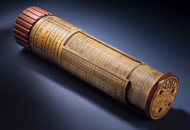
Bygrave Position-Line Slide Rule.
Andrew Johnston (geographer, Center for Earth and Planetary Studies, National Air and Space Museum) gave a presentation about the exhibit at ION GNSS in Nashville, Tennessee.
In the 1970s, Parkinson was the chief architect and original program director for GPS. In his lecture, he will present the history, applications, and future of GPS and the GNSS. Central to operation of GPS is the relationship between time and navigation, and GPS will be explored in the Time and Navigation exhibit.
Dr. Bradford W. Parkinson, professor of Aeronautics and Astronautics Emeritus at Stanford University will discuss “GPS for Humanity — The Stealth Utility” at a special Smithsonian event Thursday, March 21.
In the 1970s, Parkinson was the chief architect and original program director for GPS. In his lecture, he will present the history, applications, and future of GPS and the GNSS. Central to operation of GPS is the relationship between time and navigation, and GPS will be explored in the Time and Navigation exhibit.
Position, navigation, and time (PNT) are essential enablers for warfighter capabilities. They are used in virtually every weapons system of the Department of Defense. The GPS system has become the ubiquitous provider of this military service. In addition, GPS is the backbone of scores of civil applications that have provided startling improvements in safety, productivity, and convenience.
Credit for this achievement should go to the thousands of developers, researchers, and operators. In particular, Air Force Space Command under the leadership of Gen. Willie Shelton has consistently recognized its global stewardship for GPS, the stealth utility.
That said, the job is far from over. New threats, needs, and challenges must be met. The essential overarching goal is PNT Assurance. While GPS is an outstanding system, there are still areas for improvement. In providing PNT assurance, what should be the highest priorities for those improvements? Of course an answer to this question could involve many aspects or dimensions. The GPS Independent Review Team (IRT) focused on a number of attributes it designated as The Big Five.
Instead of the Big Five, for the purpose of this discussion, I would like to examine three key attributes. These could be applied to GPS or any other, alternative, PNT system.
I call these three essential attributes the Three As. They are:
Availability
Affordability
Accuracy
I will discuss each briefly and then add some improvement goals for each attribute. I call these improvements my personal Druthers.
Availability of Position, Navigation and Time
Without assured PNT availability, the warfighter cannot depend on the effectiveness of his weapon systems. Neither can civilian users count on their attendant benefits. To achieve GPS availability, the first requirement is adequate satellite geometry. Fewer than four satellites in view implies that the user will not have a PNT solution. A military user in the middle of a desert does not stress this geometry problem. More difficult is warrior support in mountainous or urban terrain. The steep mountains of Afghanistan can cause availability outages exceeding 10 hours per day for the currently specified 24-satellite constellation. The Department of Homeland Security has similar challenges in urban areas. Many effects-based studies have shown that 30 active satellites plus three spares are the knee in the availability curve.
A 30-satellite constellation plus three spares (optimally distributed) greatly increases availability for the sky-challenged user. Special Operation Forces in mountainous areas or Army forces in villages have precision location and can promptly designate fleeting targets of opportunity. A 30-satellite constellation assures civilian emergency service providers that they can meet their obligations in domestic urban canyons.
There are two new GNSS programs being developed that emulate GPS, named Galileo and Compass. They have made similar availability calculations and both are nominally sized at 30 satellites or more.
To maintain GPS as the gold standard, I therefore propose my first druther:
Druther One. The Department of Defense (DoD) should define the GPS constellation to be 30 satellites plus 3 spares distributed in an optimal manner.
The second aspect of availability is that the user must be able to receive the signal. Independent advisory groups have repeatedly called for increased interference-resistant solutions for the last 14 years. The technical solutions to produce virtually jam-impervious receivers are well-known. More than 33 years ago, the GPS Joint Program Office, allied with a creative program at Wright Patterson Air Force Base, demonstrated over 100 DB of J/S or anti-jam (AJ) resistance. This is enough resistance to defeat any jammer less than 1 kW in effective power. The techniques included deep integration with inertial units, controlled reception pattern antennas (CRPA), and averaging using low-phase noise clocks. To counter the problem of blinking jammers, the CRPA should be beam steering rather than null steering. This leads us to:
Druther Two. The installed GPS user equipment in both commercial and military aircraft should be able to fly directly over a 1 kW jamming source with no effect.
This is readily achievable with technology we understand. We need not employ high anti-jam techniques in all receivers; however, both the DoD and the Federal Aviation Administration (FAA) need to focus on GPS jamming resistance as a requirement. That said, the developers and manufacturers still must focus on affordability for these AJ solutions (see below).
To ensure availability, and to discourage the use of enemy jammers, the U.S. government should deploy augmentation, that is, backup systems. Recently, psuedolites (ground-based transmitters of GPS ranging signals) have become a focus for augmentation. I remain deeply skeptical concerning psuedolites in a fluid battlefield situation. Psuedolites do not perform well for attributes two and three: affordability (including operational complexity and support structure) and accuracy.
Alternatively, low-cost or navigation-grade inertial units are potentially viable augmentations, and the FAA is investigating enhanced versions of distance-measuring equipment (DME) and tactical area navigation systems (TACANs). In addition, a recent study highlighted the value of an enhanced long-range navigation (eLoran) system with its high-power, low-frequency signal. These augmentation alternatives deserve further study.
Spectrum Threats. Federal Communications Commission- (FCC-) licensed jammers are an emerging threat to GPS. Somehow, a myth has grown up that the GPS band is underutilized, and that additional services should be licensed in adjacent frequency bands. With well over a billion users, the GPS spectrum is definitely not underutilized.
An example of the licensing threat is the FCC tentative approval for high-powered, terrestrial, communication transmitters in the band immediately adjacent to GPS. This band had previously been reserved for quiet communication signals from satellites (including GPS corrections). Extensive independent testing has shown that high-powered terrestrial transmitters would have an immediate and devastating effect on military receivers, aviation and commercial receivers, including those used for precision applications such as farming. Fortunately this threat has been, at least temporarily, postponed. Many inquire why GPS is so fragile that it cannot tolerate high-powered transmitters in adjacent bands. Unfortunately, because the proposed 15 kW transmitters/jammers are not those of an enemy, we cannot bomb them. An enemy jammer of such magnitude would not get off so lightly. This leads to:
Druther Three. Ensure the Federal government, particularly the FCC, maintains the frequency bands adjacent to GPS as a quiet neighborhood as they are now.
Affordability of the PNT System
All Federal discretionary programs are under enormous budget pressure. With the threat of sequestration, the DoD is particularly susceptible. The doomsday budget may be rapidly approaching.
For GPS, the most visible segment is spacecraft. Many advocate dual-launch capability, for GPS launches. Launch costs are roughly half the cost of a satellite on orbit. Thus, dual launch could eliminate 25 percent of the cost for this capability. Of course, the real issue is the total cost of a satellite operationally deployed on orbit. A triple-launch capability, or satellite size reductions compatible with more affordable space launch vehicles, will help reduce this total on-orbit cost. This leads us to:
Druther Four. Total on-orbit GPS satellite cost should be less than $175 million.
The GPS program office recently initiated an affordable satellite design study to reduce satellite cost. The affordable satellite should broadcast all GPS signals, with no extra payloads except a laser reflector (a small passive device, added for accuracy).
Additionally, the radio frequency (RF) chain should be improved to create greater efficiency with either gallium nitride power amplifiers or traveling wave tube amplifiers (TWTAs). With the 30+3 orbital configuration, military power should be specified at a 15° Earth mask angle (rather than the standard 5°), which would significantly reduce the amount of RF power required. With an affordable 30+3 SV constellation, users should easily lock on to four, full-power satellites above a 15 degree elevation mask. No flex-power capability need be included since the advantages of the few DB that flex power offers are more easily obtained with user equipment modifications. The net result of these modifications could produce a reduction of approximately 75 percent in the power needs of an operational GPS satellite. Such reductions generate significant savings in satellite weight and cost, as well as making dual or triple launch much more easily achievable.
The military GPS user equipment (UE) program has come under considerable and warranted criticism because military UE does not afford the user the flexibility nor ease-of-use found in less-expensive commercial and/or civil GPS receivers. The current UE program office initiative to demonstrate the advanced design of front-end chips seems a good initial step. In addition to demonstrating representative military applications, the JPO should develop a simple, intuitive, GUI interface similar to existing commercial handheld devices such as Apple, Magellan, Trimble, Garmin, or TomTom. Further, to attain affordable jam resistance, the CRPA costs must be reduced using digital electronics and commercial practices.
This background leads to:
Druther Five. The military GPS user equipment (UE) program should include front-end interfaces conversant with the best commercial devices including small handheld receivers.
Druther Six. The AJ program should leverage modern advances in commercial digital electronics, producing more affordable CRPAs and using the state-of-the-art micro-electromechanical systems (MEMS).
Additionally, the GPS Control Segment should re-examine current and future requirements, particularly those related to training the relatively inexperienced military cadre. A shift to a more permanent, technically-sophisticated, civilian cadre is probably warranted, retaining a military operational commander to direct the essential warfighter capabilities.
Accuracy
In this discussion, accuracy includes bounded inaccuracy: limiting the probability of errant weapons and inaccurate positioning.
For the military, weapons delivery accuracy is usually parsed into three contributors:
target location error (TLE),
weapon location error (WLE), and
weapon guidance error (WGE).
All three components can be affected by GPS accuracy. Focusing on the Special Operations, Army, and Marine operators, the TLE today is limited by the ability of the target designator to determine azimuth. To ensure weapon delivery accuracy is 5 meters or better, we need:
Druther Seven. The DoD should develop and deploy an affordable azimuth-determination device for forward observers with an accuracy that is better than one milliradian.
For GPS, accuracy and bounded inaccuracy is a combination of geometry and user ranging error for all users. Druther One assures the geometry for virtually all users, but it bears repeating here:
Druther Eight. The GPS operational on-orbit constellation size requirement should be set at 30 satellites plus 3 spares. This repeat of Druther One greatly improves both accuracy and availability for many users.
Further improvements can be made in the inherent GPS ranging error through more accurate and sustainable atomic reference systems (clocks) and more accurate measurement of GPS satellite positions (ephemeris) by the user segment. This leads to:
Druther Nine. The GPS program office should pursue a vigorous effort to improve spacecraft atomic reference systems (clocks) and provide retroreflectors onboard all operational GPS satellites.
This will prove particularly beneficial to all users because long-range ephemeris accuracy and clock predictions will improve significantly.
As a longtime participant and observer of the GPS program, I would like to submit this wish list (see sidebar) of druthers to government decision-makers. In particular, if the Department of Defense were to act on these requests, I would regard it as a wonderful Christmas present for all users. Hopefully it will be for an immediate Christmas rather than a Christmas in the indefinite future, which I may not be around to see.
Thank you for your attention.
Brad Parkinson’s Wish List
Availability of PNT
1. The DOD should define the GPS constellation to be 30 satellites plus 3 spares distributed in an optimal manner.
2. The installed GPS user equipment in both commercial and military aircraft should be able to fly directly over a 1 kW jamming source with no effect.
3. Ensure that the federal government, particularly the FCC, maintains the frequency bands adjacent to GPS as a quiet neighborhood.
Affordability of PNT
4. Total on-orbit cost of a GPS satellite should be less than $175 million.
5. The user equipment program must include front end interfaces conversant with the best commercial devices including small handheld receivers
6. The AJ program should leverage modern advances in commercial digital electronics, producing more affordable CRPA’s and using the state-of-the-art MEMS.
Accuracy, Bounded Inaccuracy
7. DoD should develop and deploy an affordable azimuth determination device for forward observers with an accuracy that is better than one milliradian.
8. The GPS operational constellation requirement should be set at 30 satellites plus 3 spares.
9. The GPS program office should pursue a vigorous effort to improve spacecraft atomic reference systems (clocks) and provide retroreflectors on all operational GPS satellites.
Bradford w. Parkinson was the original chief architect, advocate and Program Director for GPS. His numerous awards include the Draper Prize, sometimes considered the Nobel for engineering.
He adds, “All thoughts are mine, and should not be assumed to be the views of the GPS Independent Review Team, the Department of Defense, or any GPS manufacturer.”
As part of the Stanford Engineering Hero Lecture Series, Brad Parkinson will present a talk on “GPS for Humanity” Monday, April 30, at 7 p.m. Pacific Time. The lecture will be broadcast online at no charge. If you would like to view the live broadcast, register at the Stanford University site.
In large part, Parkinson will present the story he told in GPS World, The Origins of GPS, Part 1 and Part 2. Here is the lecture description:
More than anything else, GPS has become the United States’ gift to humanity. Cell phones rely on GPS for timing. Ship and aircraft carry multiple GPS receivers to provide positioning information. Other applications range from earth movement to disease tracking to search and rescue. Dr. Bradford Parkinson, chief GPS architect and Stanford Professor Emeritus of Aeronautics and Astronautics, will describe the origins and applications of GPS and explore its future, including one application enabled when the world has more than 50 interchangeable civil signals.
Bradford Parkinson is chief architect of the now-ubiquitous Global Positioning System (GPS), which he led as a U.S. Air Force colonel in 1973. As a professor at Stanford, he pioneered GPS for aviation and other applications, including the Wide Area Augmentation System (WAAS) used by the FAA. More recently, he led the NASA/Stanford Gravity Probe B program that validated Einstein’s General Theory of Relativity to an unprecedented accuracy. Parkinson is co-editor and an author of the best-selling textbook, Global Positioning System: Theory and Applications.
So it has come to this. LightSquared officers want the FCC to investigate Brad Parkinson.
Senator Joe McCarthy is not a good look for them.
A young attorney of my acquaintance, who also happens to be a contributing editor to this magazine, wrote me in this regard:
“Lawyers have an old saying — when you don’t have the law on your side, pound on the facts; when you don’t have the facts on your side, pound on the law; and when you don’t have either, pound on the table.”
It appears that LightSquared has run out of technical solutions that it has variably proposed, without coming up with any to solve interference with the full range of GPS uses and users, and is now reduced to complaints about process. Engineering was never its strong suit, and there are many cautionary lessons to be learned from its near-run at GPS demolition. Financiers and lawyers can bring a whole heap of spectrum danger with just a little knowledge.
In coverage of this issue over the past year, I have tried to keep the magazine and its various newsletters away from the posturing and saber-rattling on both sides, the stock-market speculations and the wireless industry tea-leaves reading, and stick instead to the facts: test results, official statements by government agencies, and so on. You gentle readers have plenty of other outlets for hyperbole and flights of imagination that you can go to for that sort of thing, and it’s never in short supply. I hope we have served you well.
I had the honor of attending Colonel David Maddens’ retirement luncheon at the Space and Missile Systems Center (SMC) on Los Angeles Air Force Base (LAAFB) on June 16, and it was quite an event. Just prior to it, I asked Dave if he would like to conduct an exit interview after he took a short vacation with his family. He agreed it would be a good idea and a way to say some things he has wanted to say for awhile.
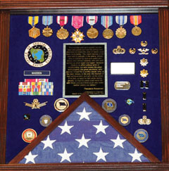
During the retirement luncheon, various people and organizations presented Dave with mementos of his time at the GPS Wing; I stopped counting at approximately 50 different presentations. This is an indication of the high regard in which Dave is held by those with whom he works on a daily basis. The military shadowbox he was presented (see photo), which is a typical military farewell presentation, had the following inscription, which is certainly not typical, and sums up the way those who work with Dave feel about him as a commander and as a person.
SHADOWBOX presented to Col. Madden on his retirement. The quote reads, in part,“The credit belongs to the man who is actually in the arena, whose face is marred by dust and sweat and blood, who strives valiantly, who errs and comes up short again and again, because there is no effort without error or shortcoming, but who knows the great enthusiasms, the great devotions, who spends himself for a worthy cause; who, at the best, knows, in the end, the triumph of high achievement, and who, at the worst, if he fails, at least he fails while daring greatly, so that his place shall never be with those cold and timid souls who knew neither victory nor defeat.” Theodore Roosevelt, 1910
“It is not the critic who counts: not the man who points out how the strong man stumbles or where the doer of deeds could have done better. The credit belongs to the man who is actually in the arena, whose face is marred by dust and sweat and blood, who strives valiantly, who errs and comes up short again and again, because there is no effort without error or shortcoming, but who knows the great enthusiasms, the great devotions, who spends himself for a worthy cause; who, at the best, knows, in the end, the triumph of high achievement, and who, at the worst, if he fails, at least he fails while daring greatly, so that his place shall never be with those cold and timid souls who knew neither victory nor defeat.”
Theodore Roosevelt
“Citizenship in a Republic,”
Speech at the Sorbonne, Paris, April 23, 1910
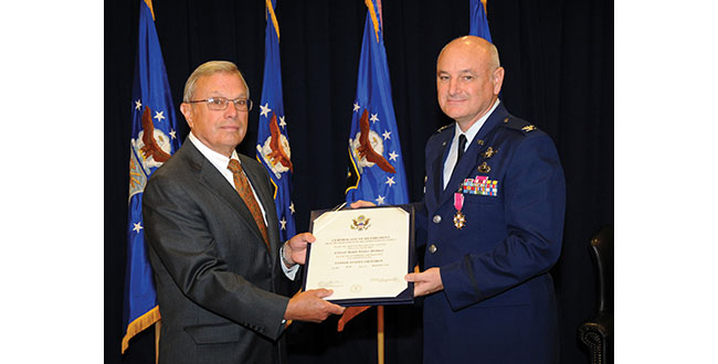
Dave was officially retired the next day by Colonel (USAF, retired) Bradford Parkinson. Dr. Parkinson was the first GPS Joint Program Office Director, in the early 1970s. He recently reviewed those early days and those responsible for the success of GPS with a two part series in the pages of GPS World.
Interview
Don Jewell (DJ): Dave, after almost four years first as the Vice Commander and then for the last three years the commander of the GPS Wing, of what are you most proud?
Colonel David Madden (DM): Overall, the GPS Wing has made significant progress over the years moving critical space system developments and acquisitions forward. The GPS Wing continues to lead with a “back-to-basics” foundation of rigorous system engineering, incorporated strategies like parallel risk reduction and capability insertion efforts, incremental delivery of timely and valuable capabilities to warfighters and civil users, and best business practices with solid cost estimates and contract incentives. Our new GPS III space vehicle, Next Generation Control Segment, and our GPS Modernized User Equipment programs incorporate our latest thinking of these innovations, and pave the path as a model for future acquisitions: low risk and high confidene associated with program execution (cost, schedule and technical performance).
The GPSW Team has had many specific accomplishments over the last four years. I would like to highlight just a few.
Space Segment. In the space segment, we accomplished a major milestone in GPS history with the launch of the final GPS IIR-M satellite in Aug 2009. GPS IIR-21 (M) marked a critical milestone in the GPS modernization program that was initiated in early 2000. The GPS IIR/IIR-M satellites are the cornerstone of the GPS constellation, and I expect them to perform well into the future. We’ve completed the development, testing and launch operations of the first GPS IIF Space Vehicle. The GPS IIF is the “Dawn of a New Era” of GPS services, providing new and improved capabilities that will continue to support not only the warfighter but commercial and civil users around the globe. IIF vehicles two and three will be delivered by early 2011, and two of the remaining nine fixed-priced vehicles are already proceeding down the Boeing Pulse Line.
Another noteworthy accomplishment was the award of the GPS III spacecraft contract. The GPS III will be developed in three increments with each increment to include more capabilities based on technical maturity. We successfully completed the GPS IIIA satellite Preliminary Design Review (PDR) in May 2009 and the GPS IIIA Critical Design Review (CDR) is scheduled for August 2010, two months ahead of schedule, which completes the detailed design and lays the foundation for fabrication. GPS IIIA is a back-to-basics spacecraft program with a strong focus on systems engineering, mission success, and acquisition excellence.
Ground Segment. In the GPS ground control segment, great lengths were taken to ensure the successful replacement of the decades-old command and control (C2) system with the new Architecture Evolution Plan (AEP) software, to improve GPS operator interfaces while providing a test capability for the new signals on the modernized satellites and to improve launch, anomaly, and disposal (LADO) operations. This new software will also provide robust security improvements to include “over-the-air” distribution (OTAD) of encryption keys to properly equipped military users.
I would also like to mention the successful award of the Next Generation Control Segment (OCX) back-to basics contract. The current acquisition strategy for fielding the OCX consists of four increments (commonly referred to as Blocks). The recently awarded OCX contract consists of Blocks one and two [while] Blocks three and four will be follow-on contracts that align with the future GPS IIIB and GPS IIIC spacecraft capabilities.
Colonel (USAF, retired) Bradford Parkinson congratulates Colonel Dave Madden on his fruitful career and retirement.
User Segment. In the GPS user equipment segment, we are actively working the development of a new generation of military user equipment to take advantage of the modernized M-Code [military only] signals. Currently we are conducting technical demonstrations and risk reduction for our next generation Military GPS User Equipment (MGUE) and defining a creative acquisition strategy.
USD-AT&L (the undersecretary of Defense for Acquisition, Technology and Logistics) signed an acquisition decision memorandum (ADM) on May 24, 2010, approving a material development decision for MGUE: the formal entry point for MGUE into the acquisition process. Currently, our three Military User Equipment (MUE) contractors are testing and delivering prototype cards this summer; government testing follows.
The foundation of our MGUE acquisition strategy is an incremental approach that leverages technology developed under the MUE program to move into engineering and manufacturing development of the first MGUE receivers as soon as possible. The strategy will be submitted to the Pentagon this summer after SMC coordination and PEO Space approval.
Our business strategy over the long term is to develop common GPS modules (CGMs) as the core engine for all DoD user equipment. We will develop CGMs incrementally as well, to support the form factors for the air, maritime, and ground domains. By early fall, we will have a final technical requirements document (TRD) for the MGUE form factors and CGM. We expect an RFP release in Feb 2011, and a Milestone A in May 2011. By early FY12, we should be on contract for Increment One of MGUE.
System Sustainment. From a systems sustainment standpoint, our GPS Wing detachment located at Peterson AFB has exceeded all expectation associated with ground (softwa
re and remote sites), user, and satellite systems sustainment. Even with all the system upgrades over the past year our sustainment team has kept the operational system performance well above the requirement: Read, no capability impact to civil or military users.
In fact, performance (availability, accuracy, and integrity) has been significantly improved over the last four years. Finally, they are normalizing sustainment of the current user equipment (DAGR-Defense Advanced GPS Receiver, MAGR-2K-Miniaturized Airborne GPS Receiver Version 2, and ADAP-Advanced Digital Antenna Production program) by transitioning sustainment responsibility to Air Force Material Command, specifically the Warner Robins Air Logistics Center depot at Robins AFB, Georgia.
Partnerships. The GPS Wing has established a close working relationship with Air Force Space Command Headquarters at Peterson AFB, Colorado for overall system operations, sustainment, and development responsibility; the 45th Space Wing (launch operations teams at Cape Canaveral Air Force Station in Florida), the 50th Space Wing (Overall System Operators at Schreiver AFB in Colorado), the Launch and Range Systems Wing (Los Angeles, California acquisition organization with responsibility for getting our GPS satellites successfully to orbit), the United Launch Alliance, the many government agencies (FAA, DOT, DOE, NSA, NGA, NASA, and so on), OSD organizations (PA&E, NII, AT&L, DOT&E), and our dedicated and professional prime contractors and major subcontractors to successfully sustain and enhance GPS mission capabilities — providing the highest overall daily system availability and the most robust GPS on-orbit constellation ever for war fighters and civil users worldwide. The constellation is healthier than it has ever been, and with the launch of the first IIF satellite and the on-track development of GPS IIIA, we are poised to maintain GPS as the gold standard for positioning, navigation, and timing well into the future.
The People. Finally and most importantly, I am proud of the men and women that make up the GPS Wing. They have molded many players (Aerospace, MITRE, service reps, international officers, government and civil agencies, SE&I and SETA (support) contractors, and U.S. Air Force military and civilians) into a finely tuned machine that is always focused on the number one priority: mission success. At the same time they have made the Wing a fun place to work. The GPS Wing members have made significant contributions to the quality of life in the GPSW, on LAAFB (Los Angeles Air Force Base), and the local community. Whether it was the great Company Grade Officer Association activities, tasty Tuesdays, the BBQs by the base gym, the holiday parties, the POW/MIA (Prisoner of War/Missing in Action) Run, the yearly toy contributions to the Marine Corp Toys for Tots program, regular food drives to support the Redondo Beach community, the yearly car show, the GPS Partnership Council, GPS University, or the many visits to local schools (just to name a few activities), they are truly a class act of which I was honored to be a small part.
DJ: Dave, how would you most like to be remembered?
DM: As the “AGER” guy. The one who put the enterprise back together, which will lead to better synchronization among the segments and ultimately deliver future warfighting capability to the U.S. and Allied forces. Senior AF, DoD, and Congressional leadership now look at GPSW execution as a enterprise rather than a collection of individual ACAT 1D (Acquisition Category 1D) programs. This has allowed the modernization program to move forward, significantly reducing the numbers of reviews, documents, and decision complexity.
DJ: Dave can you explain just where we are today in the ongoing GPS-IIF saga? Are we on track and on schedule to have IIF-1 activated sometime in late August? Will there be a second IIF launch this calendar year? Does Boeing finally have it all together?
DM: Don, I’m actually glad you asked the question that way, because it gives me an opportunity to address it squarely. It is completely fair to call the GPS IIF program a saga because of how long it took us to get to our first launch. But it is also important to ensure the credit and blame gets spread properly. The program did suffer from the sins of acquisition reform in the 1990s — on the government side and the industry side —- as well as major requirements changes years after program initiation. In hindsight, I’d have to say that we collectively failed again in the mid 2000s when we were overly optimistic about the time and funding needed for the challenges we would face in recovering from TSPR (Total System Performance Responsibility). On the flip side, during my tenure here I’ve had great support from my senior leadership — and from their Boeing counterparts — for taking the time necessary to ensure we have a quality program. We kept our eye on mission assurance and fixed quite a few end-of-life risks. We might not have had that luxury if the constellation weren’t so robust over the past few years.
In the end, the proof is in the on-orbit performance. So far, I’m proud to say that the checkout of SVN-62 has been proceeding very smoothly. My guys and Boeing have a great working relationship with the crews up at the 50th Space Wing, so the bird is in good hands. I expect we’ll find a few things we want to tweak before making the satellite available to users. Most space programs do that with the first satellite of a kind. In the end, the users will have a satellite that adds real benefit to the constellation performance.
Right now the teams are still pushing hard to get SV-2 ready to launch. There are still a few hurdles to clear, and the leadership needs to evaluate whether or not the constellation really needs another GPS IIF just yet or can it wait until next summer. I would love to watch another one go up this year, but it just won’t be the same watching from the sidelines!
DJ: I know it won’t be the same, Dave, but it should still be exciting. Now how about an update on the OCX program and how it is progressing?
DM: The OCX program is off to a great start. We awarded the contract to Raytheon in February 2010 and kicked off the integrated baseline review (IBR) in March. We are currently working side-by-side with Raytheon to solidify the program management baseline so we can jointly manage the program in a back-to-basics manner. Phase B software development for controlling modernized features is underway and builds on Phase A products, which we demonstrated with a prototype in December 2008. I have tremendous confidence that the OCX program will deliver promised capabilities on time to support modernized GPS.
DJ: Can you give us an update on where we are with the GPS IIIA program? Have you been successful in maintaining the no-changes mandate?
DM: GPS IIIA has maintained a stringent, back-to-basics approach since program inception. This has included significant investment in early systems engineering, and strict requirements discipline. To date, no new requirements have been levied on the GPS IIIA. Any new requirements for consideration are being addressed in future blocks as planned. The program is currently on track, and is forecasting the completion of Critical Design Review 60 days ahead of the baseline schedule.
DJ: We have satellites on orbit today that will reach their mean mission duration without broadcasting all resident signals or using all capabilities? Is there a plan to address this issue?
DM: Although there is some concern that the IIR-M satellites may reach their end of life before the L2C capability has been deployed, or that the IIF satellites may reach their end of life before L5 has gone operational, the concern is not justified by our reliability predictions and our current program plans. Current plans are for OCX Block 1 to provide L2C support, which is projected in the August 2015 timeframe, whereas the IIR-M satellites are expected to live well into the 2020 timeframe. Likewise, OCX Block 2 will provide L5 support in the 2016 timeframe, and our IIF satellites are expected to live into the 2025 timeframe. Therefore the likelihood that IIR-M or IIF satellites will be decommissioned before L2C or L5 have become operational, respectively, is very low.
Over the last couple of years, lots of discussion has gone into the integration issue, but I am not really sure what providing fully integrated GPS capability really means. What I do know is the user needs all three segments (satellite, ground command and control, and user equipment) to fully utilize new system capability. I also know that system integration comes in two forms. First and foremost from a technical design standpoint. This allows individual segments to be delivered independently but with high confidence the system will operate when all three elements arrive. This gives flexibility to the dynamics associated with budgets, policy decisions, requirements changes, unexpected technical hurdles, launch availability, and weapon platform availability for integration and testing (just to name a few variables). Rest assured the GPS enterprise is integrated at the technical level. However, it’s the second form of integration that gets all the attention: having all segments delivered in a reasonable proximity to each other. Not to make excuses, but as it relates to GPS, this is just hard to accomplish because it involves a span of control and accountability that is almost infinite. Many in the community recognize this reality, which has allowed the Air Force to set appropriate and realistic expectations so real capability can be delivered.
That being said, there are prudent things that can and are being done to speed the deployment of capability and set appropriate expectations. The most significant has been to broadcast the M-Code, L2C, and soon L5 signals from space to allow civil and military user equipment manufacturers to begin development and testing of their next generation of receivers. This gives industry a jump while the U.S. Air Force continues to develop the C2 capability and the next-generation signal monitoring capability (required to ensure signal in space performance integrity). Also, building the modernization programs with a strong mission assurance foundation is a major step forward. We understand the lessons learned that established the baseline for the current Block II systems delivery; the Block III systems are built on a solid acquisition strategy of reduced risk and increase execution confidence.
DJ: What do you see as one of the biggest GPS enterprise challenges, and what are some of your thoughts on the way ahead?
DM: That’s easy, Don: ensuring global PNT services are not interrupted as the United States continues to modernize GPS. If we don’t continue to develop a more robust means of ensuring user equipment compatibility, even a small number of non-system-compatible receivers (military or civilian) can significantly delay the delivery of critical modernized capability for everyone. Let me explain and provide some thoughts.
Since its initial design in the early 1970s, GPS has evolved in both capability and complexity. In the early days, systems engineering across the space, control, and user segments was relatively straightforward. The GPS Joint Program Office developed all military user equipment, and was able to rigorously ensure all specifications were verified prior to fielding. Over the past 20 years, however, GPS has become ubiquitous throughout the Department of Defense, with tailored satellite navigation solutions developed and acquired by dozens of program offices to support hundreds of unique requirements. Meanwhile, commercial GPS is one of the foundations of the Information Age, with GPS receivers produced in quantities approaching half a billion devices per year. The model of simply providing policies, standards, and interface control documents without providing a means to certify receiver compliance is becoming more challenging due to the continued growth in both military and civil applications for PNT, the competitive nature associated with user system applications and performance, and the increased complexity of GPS. Furthermore, it is especially difficult fielding upgrades to an established system like GPS while maintaining backwards compatibility with previously fielded equipment. These challenges are further exacerbated by difficulties associated with synchronizing the lengthy timelines associated with fielding ground-segment, satellite, and user equipment upgrades.
Recent highly isolated incidents, involving civilian and military receiver and other manufacturers, have highlighted the significant impact a very small number of receivers experiencing compatibility issues can have on the entire enterprise of worldwide users. In addition, a number of cases associated with improper receiver integration into major weapon systems have delayed system fielding as well not allowed the weapon system to best optimize GPS to the overall weapon systems performance.
Therefore, it is my opinion, to ensure worldwide PNT services are not interrupted as we continue to modernize the GPS, a more robust means of ensuring compatibility needs to be explored. (I would like to stop and make a note here: by “we” I mean all the DoD and civil agency stakeholders.) This means we need to not only continue to release “building codes” but we need to develop a capability to be more involved in the development, integration, and testing of new military and possibly civil user equipment.
We have recently taken a number of big steps in this direction.
First, we are currently significantly increasing the number of civil and military GPS receivers in our government testing labs. This will enable us to run tests against a wider variety of receivers, to gain higher confidence before we deploy system upgrades.
Second, we recognize that we need to ensure that our signal specifications, for both military and civil users, are as clear as we can make them. User-community representatives are already encouraged to be full participants in appropriate interface-control working groups. We further recognize that there is no substitute for thorough testing, and hence fully appreciate the importance of deploying signal-in-space capabilities as early as possible, on predictable schedules, so user equipment can be field-tested prior to market release or operational deployment.
Third, we are developing new upgrade fielding methodology whereby when we deploy system upgrades, we will take a more methodical approach and, whenever possible, field upgrades to smaller segments of receivers to prove compatibility without exposing all operational assets simultaneously. We will also apply a new software sustainment model to future military GPS user equipment, to ensure that inevitable system changes are systematically and rigorously executed with minimal impact on DOD programs.
Finally, we are investigating the establishment of something similar to an underwriters laboratory service to help support military programs with integrating GPS into their weapon systems during development. The teams associated with such lab services would support program design reviews as well as help develop the validation criteria for overall system acceptance. In addition, we are also starting discussions with key GPS civil receiver developers on how we might be able to provide a similar service to commercial receiver developers (potential fee-for-service type model).
Don, I highly recommend we continue to develop the four efforts I just mentioned but also dedicate significant time to critical thinking events to ensure we have minimized the risk of a widespread receiver issue, delays in delivering modernized capabilities, or sub-optimized weapon system performance. Manufacturers of equipment adversely affected by recent GPS upgrades have significantly stepped up their interactions with the GPS program office to resolve the compatibility issue and are playing a major role in providing an upgrade to their affected receivers to correct the issue. To date, no operational weapon systems have had to be grounded or civil capability degraded. I encourage the GPS community to treat recent events as a call to arms. GPS has become a critical national and international utility but it is much more complex than the electric or telephone services. How military or civil GPS receivers are designed, developed, and integrated into systems has a significant impact on the overall performance or lack of performance of the system. Don’t let recent events be a lesson not learned; let’s lead and solve the risk before it becomes an issue.
DJ: These are all excellent ideas, Dave, and many of them we have discussed in the past as concepts. It sounds like many of them are now a work in progress, but since you won’t be around to shepherd them into fruition, just what sort of prudent advice would you give Colonel Bernie Gruber as he assumes command of the GPS Wing?
DM: First and foremost, listen to your people — we have a great team! They are skilled professionals who really care about GPS. Second, keep the MGUE program focused and moving forward.
DJ: I certainly hope at a minimum that Bernie listens to your advice on MGUE. Now, Dave, when will the GPS Wing transition back to a Joint Program office, and what affect will this have on the military personnel working GPS? Will this re-designation be detrimental to their careers and future plans for the JPO? Will it lessen the GPS Wing’s/JPO’s influence in the GPS community and with other services?
DM: Don, we are scheduled to complete the transition and stand-up as the GPS Directorate on October 1, 2010. The Center is having one inactivation ceremony for all the Wings in SMC on September 8. The transition will be seamless and have a minimal effect on our military personnel. Our senior leadership is working on ensuring our materiel leader positions have group or squadron commander equivalency and will also be command-screened and boarded. There will not be very much difference within the Wing on a day-to-day basis. For the most part, the work, responsibility, and accountability will remain intact. The re-designation will have very little detriment upon the careers of the officers within the Wing. The officers’ records will show a transition and re-designation to explain the change, and that it is no cause of their own. As far as future plans for the organization, the strength of the leadership here in the Wing will still be in place and will be just as effective as it is now to lead each individual in our organization and to move forward and progress in GPS capabilities into the next era. Other services will still look to us to continue to forge advancements in GPS satellites so that our influence in the world’s GPS community will remain the standard: stronger than ever. Our organization will continue to acquire and sustain global navigation, positioning and timing services for our war fighters and civil users. We’ll still be the Green Monsters everyone knows and loves!
DJ: What message would you like to leave with our readers as you move on from GPS to the milsatcom community?
DM: GPS is in great hands. I look forward to the challenges ahead.
DJ: Any final comments, Dave?
DM: It has truly been a pleasure leading the GPS Team — my best job in 30 years of service. And you, Don, have also been a welcome friend.
GPS improves the quality of life for everyone on the planet. It saves lives both on the battlefield and in our cities and towns across the globe. The U.S Air Force and Air Force Space Command have been the diligent stewards of GPS since program inception in the 1970s and continue its commitment to this critical component of our national infrastructure. The current GPS constellation has the most satellites and the greatest capability ever. We are committed to maintaining our current level of service, as well as striving to improve service and capability through ongoing modernization efforts. The Air Force will continue to pursue an achievable path maintaining GPS as the premier provider of positioning, navigation and timing for military and civilian users around the world.
DJ: Dave, everyone at GPS World wishes you the best of luck in your future endeavors, and thank you for your honesty and candid responses to our inquiries through the years. You were the leader the GPS Wing needed for the last three plus years and you have left a legacy of which you can be justly proud. And in my opinion if the GPS Wing, Directorate or JPO thinks they have seen the last of Dave Madden, they should think again. Best of luck in milsatcom.
Brad Parkinson, the first GPS Program Office Director, chief architect and advocate for GPS, submitted written testimony to Congress on mitigation options for possible GPS brownouts. His presentation comes in reference to the recent GAO report highlighting the risk that the GPS constellation may fall below the minimum level of 24 satellites required for full operational capability. In his opening, Parkinson states that “GAO correctly points out the possibility that the GPS constellation will be reduced to less than the current number of 30 to 32 satellites. In fact, it is possible that the constellation will be at a level of less than 24 satellites. I would like to focus on the options that would help reduce this risk.”
Parkinson chides those who may not have been paying attention over the last two years, at least. “It should be noted that the risk of brownouts has been repeatedly pointed out by the independent review teams,” he states, referencing the the Defense Science Board, the GPS Independent Review Team, and the Pos-Nav Timing Advisory Board, who have all stated all that “30 satellites is the correct number.” He points out that the European Galileo program and the Chinese Compass system have also arrived at that number.
“Although brownouts would only be ‘officially’ declared at levels below 24, anything below the current level of 30 satellites is a cause for concern. The potential economic impact if the number were below 24 may be quite serious.”
To rectify the situation, Parkinson first gives a history lesson. The first GPS satellite went from contract award to launch in 44 months. “The keys to success were a streamlined approval chain (all the way up the OSD chain), severe restrictions on any contract changes, and an integrated product team.” He believes that GPS IIIA can achieve the same — given the same playing conditions.
Spartan. He does throw in one twist not currently in the plans: “To develop a simplified GPS IIIA based design, Spartan satellite (IIIS) that would not include the extra payloads, and, once designed, could be built quickly and launched into space with two satellites on a booster. This would be done in parallel with the current program.”
Parkinson appears to advocate complete abandonment of the IIF line. “The reason is simply that the satellite design is old and relies on parts that are no longer available. In addition, the satellite, while providing the older signals, does not meet current requirements.”
He closes with a final admonition. “Above all, the senior decision making chain has to become a part of the solution. This means that they do everything in their power to help the program office achieve the needed schedule.”
 The hounds of spring are on winter’s traces. As Galileo emerges from its long, cold slumber, the energy of a new constellation radiates through the skies to encourage blossoms across Europe. ESA’s recent declaration of in-orbit validation means the downstream satnav market can now truly get going.
 Now in its sixth edition, the Geospatial World Forum concentrates on geographic information systems (GIS) in mapping, remote sensing, satellite navigation as applied to the electricity sector and energy distribution; architecture, engineering, and construction; sustainable agricultural industrialization; smart cities, municipal management; disaster preparedness and coping, natural hazard monitoring; big data as a competitive business asset, business intelligence, and market analysis; multi-sensor integration for monitoring; geospatial’s role in healthcare; global peace and prosperity; and last but by no means least, in fact probably the most important in our long term, climate change.