I attended the China Satellite Navigation Conference in Nanjing in May, the fifth year of CSNC and my third time attending. Tremendous progress was evident this year in terms of BeiDou (BDS) deployment and China’s general openness and willingness to collaborate over those years. I have also seen a slowly growing international presence at the show and expect that to continue to increase as well. You may recall my column last year about Little Tigers. Well, they aren’t so little any more. As for the tycoons, you will have to read to the end.
The conference opened with the usual provider updates. Chenqi Ran, who runs the China Satellite Navigation Office, the lead government agency for BDS, started off. It’s always good to hear his update delivered in China, where the is a little more freedom to provide information beyond the standard pitch. China continues on pace to its plan for the third step of BDS with five geosynchronous-orbit, three inclined geosynchronous-orbit, and 27 mid-Earth orbit satellites for a worldwide system by 2020. They are meeting their stated goal of 10-meter accuracy regionally today, and as good as 5-meter near the Equator. Ran also provided interesting numbers for the fast-growing Chinese domestic market:
More than 2 million BDS chips sold in China in Q1
More than 300,000 vehicles equipped with BDS
20 domestic brands offering car navigation systems
First consumer tablet (Samsung Galaxy Note 3) with BDS.
First consumer smartphone (Huawei B199) with BDS
The updates from other providers (GPS, GLONASS, and Galileo) were relatively standard and did not contain much new information. I had hoped that maybe the Russian presentation would provide more information about the April outages, but nothing was forthcoming and I was not overly surprised.
The conference itself is very well organized and runs nine parallel technical tracks over two full days, with additional special-interest sessions. All of the presentations are in Chinese, however the conference provides headsets for simultaneous translation, and many presenters have dual slide sets in Chinese and English, so it is easy to attend anything that seems interesting.
I came as an invited speaker on the Institute of Navigation (ION) panel organized by Professor Jade Morton from Miami University, Ohio, and Professor Lu of the National Timing Service Center near Xian. The ION panel was well attended and included a short panel discussion at the end.
One of the most interesting outcomes was that both Broadcom and Trimble showed approximately 25 percent accuracy improvement by adding Beidou to their existing GPS/GLONASS solutions. It was interesting not just because they reached the same number, but because Broadcomm was talking in meters about urban-canyon performance and Trimble was talking in centimeters about precise positioning.
It became clear that everyone sees BDS as an important part of their roadmap at L1, regardless of how many frequencies they currently support. I must also note that both Professor Morton and Professor Lu were outstanding hosts and showed us some of the wonderful local sites.
Exhibit Hall
The biggest change from last year was in the exhibit hall. I would estimate the overall floor space grew by 50 percent, with 106 companies in specially designed booths (up from 56 last year) and another 44 in standard booths.
The content change was even more dramatic. Last year there were a lot of small booths with pretty basic displays, mostly of prototypes and slideshows. This year, there were many more extremely large booths that were very professionally created. They had evolved into displaying very polished-looking finished products with nicely edited videos. It was clear that this was all targeted at domestic buyers, as it was difficult to find anyone on the show floor who spoke English (except in the Spirent booth). These are no longer little tigers. These are now real companies, out hunting for new business.
Policy and Intellectual Property
My other favorite topic to listen to at this conference is on policy and intellectual property (IP). That is where I spent most of my time and was not disappointed. There was in fact an entire session dedicated to intellectual property, and several presentations on the global state of affairs of patents in GNSS.
Interestingly, most of the speakers were either lawyers or from government, but there were some corporate ones as well. Several speakers highlighted the recent disagreement and settlement of the patent dispute between the United States and the United Kingdom over complex modulation patents. There was a large element of underlying concern that although the U.S. had been able to settle the dispute, it might be very hard for China if either the U.S. or the UK came after them. They had several charts showing how far behind they were in GNSS patents, in an effort to encourage local companies to create more IP and patent it. They also showed they have made significant progress in recent years in domestic Chinese patents, though they still have a long way to go in international patents.
They were also very concerned about the largest holders of GNSS patents in China — Qualcomm and Broadcom — as a threat to domestic industry. They cited the GlobalLocate/Broadcom versus SiRF/CSR lawsuit as a cautionary tale. Several presenters showed the dominance of Broadcomm and Qualcomm in terms of domestic Chinese patent holdings and referred to them as the “Tycoons.” I envisioned Rich Uncle Moneybags, the guy from the Monopoly game wearing the top hat, walking around with patents instead of dollar bills hanging out of his hat.
Conclusion
The little tigers have definitely grown up. They are much bigger, have real teeth, and are definitely trying to stake out territory in the fast-growing domestic market. But the Tycoons still have the upper hand in the mass-market battle for consumer devices. For the moment, anyway.
The Tycoons are going to have to start spending some of their bounty in China if they want to maintain that market share against rapidly evolving domestic competition. I won’t be surprised if next year we see the Tycoons exhibiting at CSNC, and soon after that, the tigers looking to expand their hunting ground into nearby markets in Korea, India, and Japan.
Greg Turetzky is a principal engineer at Intel responsible for strategic business development in Intel’s Wireless Communication Group focusing on location. He has more than 25 years of experience in the GNSS industry at JHU-APL, Stanford Telecom, Trimble, SiRF, and CSR. He is a member of GPS World’s Editorial Advisory Board.
The statements, views, and opinions presented in this article are those of the author and are not endorsed by, nor do they necessarily reflect, the opinions of the author’s present and/or former employers or any other organization the author may be associated with.
Tri-Band Multi-Constellation GNSS in Smartphones and Tablets
This article presents a single-chip BeiDou/Galileo/GLONASS/
GPS/QZSS/SBAS architecture for use in cell phones and tablets. The authors explain the advantages to end users of multiple constellations. They also examine the details of system interchangeability, multi-system issues, and how assisted-GNSS data operates with all constellations, including BeiDou.
By Frank van Diggelen and Kathy Tan
With GPS, GLONASS, SBAS, BeiDou, QZSS, and Galileo there are over eighty operational satellites. Why do we need all these satellites in the first place? The answer is simple: in urban environments we want a few (six to eight) good satellites with an unobstructed line-of-sight (LoS) to the receiver and good horizontal dilution of precision (HDOP). In order to achieve this, we need many more satellites in space than any single constellation. In this article, we address the following issues.
Receiver intersystem RF bias with a tri-band front-end. BeiDou uses a different RF section than GPS/Galileo/QZSS/SBAS and GLONASS. As a result, there is a receiver intersystem bias between BeiDou and each of these other systems—not just because BeiDou is on a different frequency, but because of the different RF path through the receiver. We explain how this bias is calibrated and removed.
In the space segment there are intersystem biases primarily caused by differences in time standards. We discuss time management and show how the different systems can be made interoperable.
BeiDou Assistance. In order to realize the benefits mentioned, we need infrastructure deployment for BeiDou assistance in accordance with 3GPP standards. We will discuss what is available, and what is left to do.
Coverage outside of China. Europeans can see more BeiDou satellites than Galileos. At the time of writing (March 2014) they could see approximately twice as many. Thus, when used in a multi-GNSS receiver, BeiDou is far from being just a regional system. We will provide coverage analysis, and live-test data, including a focus on Europe.
Finally, we will demonstrate all of the above in practice, explaining and showing how interchangeability is achieved, and where first fixes can be computed with no more than one of each satellite type.
Figure 1 illustrates the point referenced at the beginning, that we need many more satellites in space than any single constellation.
All of the lines in Figure 1 show signals that were actively tracked by the receiver at the position shown on the right. The orange lines are to satellites that are blocked, but the reflected signal is tracked. We do not want to use these measurements if we can help it, so we need many satellites to provide enough LoS signals.
Let’s look at the HDOP of the LoS signals. In this example, the HDOP for the three LoS GPS satellites was 50. For the three LoS GLONASS satellites, the HDOP was 45. However, with the combined GNSS constellation, the HDOP for the six LoS satellites was 2.2. In other words, we expect about a 20x accuracy improvement by using the combined constellation.
There are many places and times in cities where we see just one or two direct LoS signals from a particular constellation, and we need more than just GPS and GLONASS to get the desired number of good signals, thus explaining the desire and need for all available constellations.
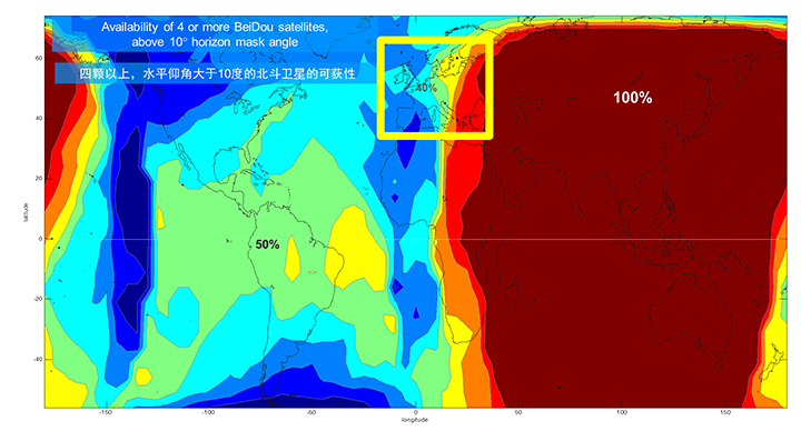
We’ll now look at the coverage provided by BeiDou2, which has five Geostationary satellites (GEOs), five inclined Geosynchronous satellites (GSOs), and four Medium Earth Orbit satellites (MEOs). With this 14-satellite constellation, the global coverage is as shown in Figure 2. This figure shows the percentage of time in a day that four or more BeiDou satellites are visible above a 10-degree mask angle. In the Asia-Pacific region, where the GEOs and GSOs are positioned, the coverage is predictably 100 percent. In fact, there are seven or eight BeiDou satellites visible in much of this region most of the time.
Figure 2. BeiDou2 global coverage.
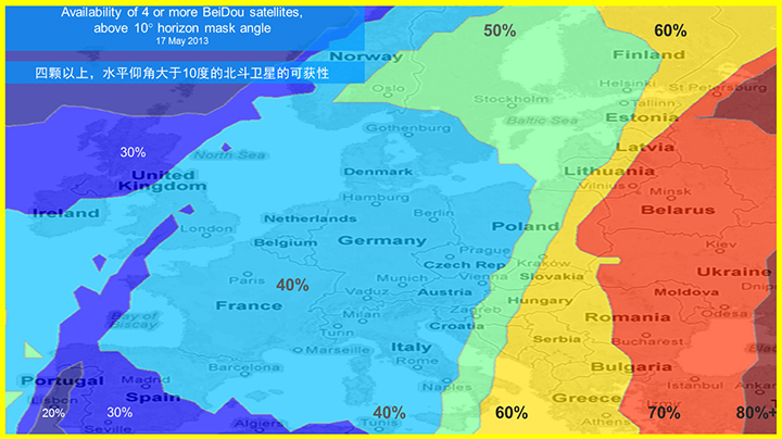
As shown in Figure 3, outside the Asia-Pacific region the coverage is also interesting. We see that at least four BeiDou satellites are available over Europe about half of the time. This is quite significant given the previous discussion; even one or two extra satellites can make all the difference in an urban environment. Another notable fact is that, for now at least, Europe can see more BeiDou than Galileo satellites.
Figure 3. BeiDou coverage over Europe. The different colors show the percent of time that four or more BeiDou satellites are visible above a 10° mask angle.
Technical Requirements
There are five significant technical requirements that we want to satisfy when creating a multi-GNSS receiver for consumer applications:
Three Separate RF Paths. To acquire and track all of the satellites already mentioned, we need three separate RF paths. Details follow in Section 3 (Front-End Architecture).
Search and Track capability for all visible GNSS satellites. The receiver must have the ability to search a very large number of code-frequency bins at once.
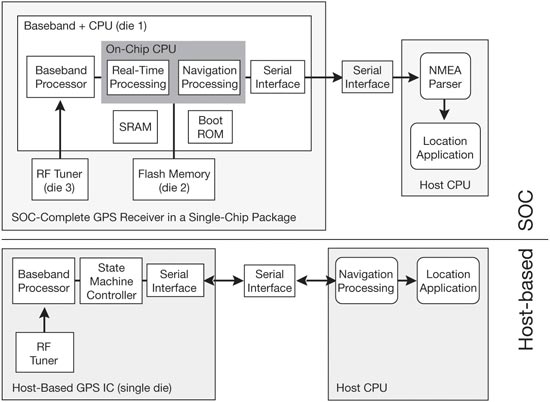
Host-Based. As much as possible, we want to make use of the host application processor (AP) and memory. This allows for tight integration with assistance data (which is coming from the host), other sensors, and other wireless data (such as Wi-Fi and Bluetooth for indoor locations). A host-based architecture also keeps size and cost as low as possible.
With Host-Offload. A significant trend in location applications is the need for “always-on low power” location. The host AP cannot be used for continuous position updates, since it draws too much power. So, while we want host-based location when the host AP is active (such as when navigating with turn-by-turn directions and a map), we also want a host-offload capability so that the GNSS chip can compute positions internally while the host is asleep.
Interchangeability. The ultimate requirement for multi-system GNSS is the ability to use any combinations of satellites as if they were all in the same constellation. This is summarized as “any four satellites will do.”
Front-End Architecture
From a cell phone/tablet perspective, the signals in space are all in the L1 band, with frequencies as shown in Figure 4. The key architecture feature of the GNSS front-end is that it should have three separate RF chains for the three separate frequencies-of-interest; see Figure 5.
Figure 4. Frequencies-of-interest for GNSS in cell phones.Figure 5. Front-end architecture showing three RF chains.
Baseband Architecture
The preferred architecture of a chip, as shown in Figure 6, is host-based to take advantage of the large host CPU when it is active. When the host CPU is asleep, a small, low-power, on-chip CPU is leveraged for background “always on” location. This enables applications such as geofencing to run without significantly reducing battery life.
Figure 6. Block diagram of the preferred architecture, showing a host-based configuration that includes a host-offload capability for geofencing and position caching on-chip when the host is asleep.
When the host is active, such as when you are actively using the phone for turn-by-turn navigation, the host AP is on and we want to make as much use as possible of the host AP and memory. This allows for tight integration with assistance data coming from the host, other sensors, and other wireless data (such as Wi-Fi and Bluetooth for indoor locations). A host-based architecture also keeps size and cost as low as possible, even with host-offload capability, which adds very little to the size of the chip.
Receiver Intersystem RF Biases
With the three different bands of frequencies, we will get RF group delays in the receiver front-end. These must be calibrated out by the receiver’s designer as part of the chip’s system design. If the group delay between BeiDou and GPS is not calibrated, it will lead to approximately three meters of bias between the two systems (Figure 7). Once it is calibrated, there is essentially no bias.
Figure 7. L1 frequency spectrum for BeiDou2, GPS, Galileo, QZSS, SBAS, and GLONASS.
Satellite Intersystem Biases
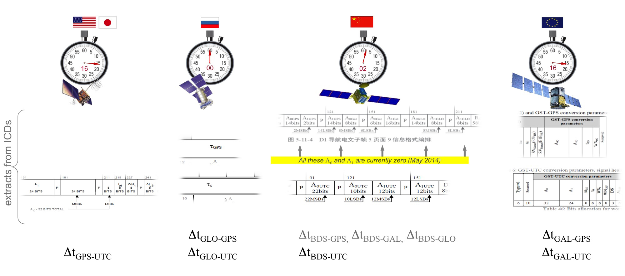
Different GNSS constellations run off their own master clocks; referenced to different realizations of UTC. GPS is referenced to UTC (USNO), QZSS is referenced to UTC (NICT), GLONASS to UTC (SU), BeiDou to UTC (NTSC), and Galileo to UTC (INRIM). GLONASS UTC (SU) differs from the others by 3 hours.
Furthermore, different systems treat leap seconds differently. This is indicated by the red arrows in the clocks in FIGURE 8. GPS, QZSS, BeiDou and Galileo system times are continuous and ignore leap seconds. Thus, each system time is ahead of UTC by a number of leap seconds. GPS time started in 1980 in synch with UTC; there have been 16 leap seconds since, so now GPS is 16 seconds ahead of UTC. QZSS and Galileo system times were started in synch with GPS. BeiDou system time was started in 2006 in synch with UTC; there have been 2 leap seconds since, so now BeiDou is 2 seconds ahead of UTC. GLONASS system time, on the other hand, includes leap seconds.
Apart from this, each of the different realizations of UTC is within several nanoseconds of the others.
To combine measurements from these different systems and avoid any time-induced intersystem biases, we need to resolve the time offsets. Each system transmits the delta-time between its system time and the systems that preceded it, as listed in Figure 8. To combine the systems, we either need to decode these data messages or obtain the delta-time values from Assisted GNSS.
Figure 8. Intersystem time differences and broadcast delta-time values from each system.
Note, however, that in the BeiDou broadcast Nav message the intersystem time-offset data values are all set to zero (even though the true offsets are not zero).
Assisted-GNSS Including BeiDou
Assisted GNSS, or A-GNSS, increases sensitivity and decreases the time-to-first-fix of a receiver by providing assistance data in the form of the receiver’s approximate position, time and frequency, as well as all data that the receiver might decode from the broadcast signals. The assistance data may also include data beyond what is broadcast, in particular, let’s focus on BeiDou time offsets. The BeiDou time offset to the other systems is included in the BeiDou broadcast Nav message as shown in Figure 8; however, at present these data values are all set to zero (even though the true offsets are not zero). Thus, in order to get these offsets and integrate BeiDou properly into a combined GNSS system, one must compute the offsets at a reference station and provide them as part of the assistance data, as shown in Figure 9.
Figure 9. A-GNSS provides broadcast satellite data over some other wireless network, as well as time-offsets between the different pairs of systems.
Commercial Implementation
The preferred architecture described in this article has been implemented in a commercial GNSS receiver that is now available for commercial host-based products, such as cell phones and tablets. The chip, Broadcom’s BCM47531, is the first consumer GNSS chip with a tri-band front-end capable of acquiring and tracking satellites from GPS, SBAS, QZSS, GLONASS, and BeiDou constellations, simultaneously; and operating in host-based mode for navigation and in host-offload mode for Always-On location.
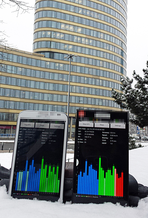
Broadcom has collaborated with leading smartphone manufacturers to launch the first wave of BeiDou enhanced consumer smartphones. Figure 10 shows one of these smartphones being tested in Europe. Note the number of BeiDou satellites in view. As predicted by the availability plots shown earlier, there are many BeiDou satellites in view (in this case, six).
Figure 10. GPS/GLONASS phone and GPS/GLONASS/BeiDou phone being tested in Warsaw, Poland. Note the six BeiDou satellites (red) that are seen and tracked by the BeiDou phone.
Interchangeability: Any Four
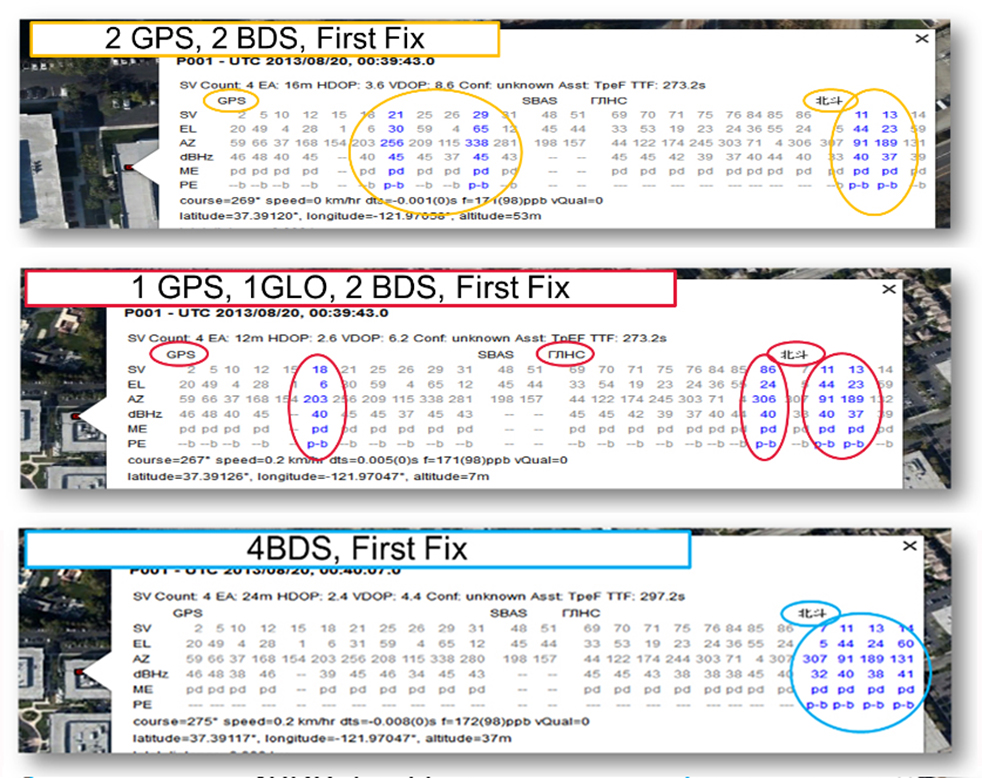
Now that we have addressed all of the major issues related to integrating different GNSS systems (in particular BeiDou), we can demonstrate the payoff.This is the achievement of interchangeability, where any GNSS satellites can be used together, as if they all belong to a single constellation. Figures 11 and 12 show assisted cold starts, where first fixes are obtained with no prior knowledge other than that provided by A-GNSS data. In each case, we show a different combination of satellites; including one satellite from each of four different constellations, and all four from BeiDou.
Figure 11. Interchangeability: Position fix with 1 GPS satellite, 1 GLONASS, 1 QZSS, and 1 BeiDou. The receiver is in Perth, Australia, where all of these constellations can be seen.Figure 12. Interchangeability: Assisted cold start, first fixes. Blue numbers show the satellites used in the position fix (top: two GPS and two BeiDou; middle: one GPS, one GLONASS, and two BeiDou; and bottom: four BeiDou only). The receiver is in San Jose, California, where four BeiDou satellites can be seen some of the time (some of the BeiDou GSOs can be seen and all the BeiDou MEOs can be seen for a few hours each day).
Multi-Constellation Robustness
While this article was being edited, the GLONASS system provided us with the most dramatic demonstration yet of the need for, and benefits of, multi-constellation receivers. On April 2, 2014, the GLONASS system failed spectacularly for a period of 11 hours. Receivers that used GPS and GLONASS had very large position errors, or no positions at all. While the receiver discussed in this article, the BCM47531, operated seamlessly. This receiver tracked GPS, GLONASS, QZSS and BeiDou satellites, correctly identified the faulty GLONASS satellites, and automatically stopped using them.
The details of the incident are as follows: The GLONASS control system uploaded incorrect orbit data to several satellites. When receivers used these satellites they had position errors of hundreds of meters, or no positions at all. At that time, the BCM47531 was being tested alongside a GPS/GLONASS receiver, and we have the data to show what happened. The receiver using only GPS/GLONASS suffered position errors of ten thousand meters, and long periods with no position at all; at the same time the multi-constellation receiver produced continual positions with normal accuracy. Figure 13 shows the test data — the left most image shows the route being driven, the middle image shows the data from the GPS/GLONASS receiver, and the right image shows the data from the BCM47531 multi-GNSS receiver. Figure 14 shows the details of the multi-GNSS receiver, you can see that no GLONASS satellites are being used.
FIGURE 13. Side-by-side tests of GPS/GLONASS receiver and multi-constellation receiver during the GLONASS incident of April 2, 2014. The GPS/GLONASS receiver produced errors of ten thousand meters and long periods with no position at all, while the multi-constellation BCM47531 operated seamlessly.FIGURE 14. Detail from the multi-constellation receiver when there is a problem with some satellites. The errors are recognized automatically by algorithms comparing the measurements to redundant measurements from the extra constellations, and the erroneous signals are not used.
This incident may raise the question: Why use GLONASS at all, why not just GPS? The answer is that in urban canyons, such as where this test was done, GPS alone does not have enough satellites to give the performance now expected in consumer products — for the reasons explained in the beginning of this article. Also, GPS, although it has been more reliable than GLONASS, is not immune to failures or jamming itself. The lesson of this incident is that reliability and accuracy comes from the combination of all the available constellations, with a receiver that can use the signals interchangeably.
Conclusion
We have shown the preferred architecture for a consumer GNSS receiver that includes all of the available constellations. We have addressed the major requirements of such a receiver for the consumer market, in particular, for cell phones and tablets. A receiver that meets these requirements is now available, the Broadcom BCM47531, has been designed into a new generation cell phones and tablets for 2014. Finally, we have shown how, with this receiver, the ultimate GNSS goal of interchangeability can be achieved.
Frank van Diggelen is vice president of technology at Broadcom Corporation, a consulting professor at Stanford University, and inventor of coarse-time GNSS navigation, co-inventor of Long Term Orbits for A-GNSS, and author of A-GPS: Assisted GPS, GNSS, and SBAS.
Kathy Tan is a senior principal engineer at Broadcom Corporation. She has worked on GNSS development and Assisted GNSS for Ashtech, Magellan, Global Locate and Broadcom. She received her MS and BS in electrical engineering from Fudan University, China.
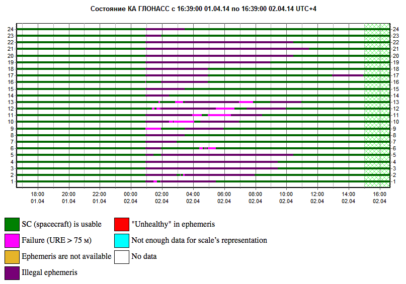
GLONASS PLOT from the Roscosmos GLONASS Information-Analytical Centre, showing the 12-hour outage, with full service eventually restored on April 2.
Two April Disruptions Furnish Fodder for Multi-GNSS Receivers and Alternative PNT
In an unprecedented total disruption of a fully operational GNSS constellation, all satellites in the Russian GLONASS broadcast corrupt information for 11 hours, from just past midnight until noon Russian time (UTC+4) on April 2 (or 5 p.m. on April 1 to 4 a.m. April 2, U.S. Eastern time). This rendered the system completely unusable to all worldwide GLONASS receivers. Full service was subsequently restored.
“Bad ephemerides were uploaded to satellites. Those bad ephemerides became active at 1:00 a.m. Moscow time,” reported one knowledgeable source. GLONASS navigation messages contain, as they do for every GNSS in orbit, ephemeris data used to calculate the position of each satellite in orbit, and information about the time and status of the entire satellite constellation (almanac); user receivers on the ground processed this data to compute their precise position.
The GLONASS fix could not take effect until each satellite in turn could be reset, during its pass over control stations in Russian territory, in the Northern Hemisphere, thus taking nearly 12 hours.
During the outage, CEO Neil Vancans of Altus Positioning Systems reported “We are currently experiencing calls from customers all over the world who are experiencing GLONASS ‘outages’ and we have advised customers to switch GLONASS tracking off on our receivers.”
Such a — possibly human, possibly computer-generated — error could conceivably occur with GPS, Galileo, or BeiDou. “Another reason to have backups,” mused Richard Langley of the University of New Brunswick. “And not just other GNSS.”
Trouble Chronolog. The constellation suffered a second failure two weeks later. On April 14, eight GLONASS satellites were simultaneously set unhealthy for about half an hour, meaning that most GLONASS or multi-constellation receivers would have ignored those satellites in positioning computations. In addition, one other satellite in the fleet was out of commission undergoing maintenance. This might have left too few healthy satellites to compute GLONASS-only receiver positions in some locations.
The two blackouts followed two other high-profile disasters: the destruction-upon-launch of three new GLONASS satellites in July 2013, and the Pacific drowning-upon-launch of three satellites in December 2010.
Internal Dialog. The semi-official Russian news daily Izvestia (“Truth”) reported that the loss of service was inconsequential for Russian users. Loose translation courtesy of Google:
“Temporary GLONASS failure has not led to tangible consequences for consumers of services because chip manufacturing exclusively with GLONASS for the mass market is practically nil: there are chips that work only with the GPS signals, and there are those that see both GPS and GLONASS.”
In other words, there are practically no mass-market devices, even in Russia, that use exclusively GLONASS.
“In any case, the failure of the entire system for a long period is a serious blow to the image of GLONASS, especially in a situation where Russia has made efforts to promote domestic navigation system to external markets. Plus in 2012, the Russian government officially promised to maintain the characteristics of the international community GLONASS at the proper level for 15 years.”
Industry View, Multi-GNSS. During the first outage, chip company Broadcom was conicidentally conducting multi-constellation receiver tests in Asia. Frank van Diggelen, the company’s chief GNSS scientist, stated, “We have definitive data to show how a multi-constellation receiver survives such an outage. Test data coincident with the GLONASS ephemeris disruption show how a GPS/GLONASS/QZSS/BeiDou receiver survives the complete disruption of one of the constellations.”
A Broadcom 47531receiver tracking GPS/GLONASS/QZSS/BeiDou signals simultaneously and using logic to analyze redundant measurements to check the validity of all measurements successfully identified and removed the bad GLONASS ephemeris, maintaining position continuity and accuracy. Another receiver under test at the same time, tracking only GPS and GLONASS, wandered significantly in its position reports.
Industry View, Back Up PNT. Calling it an “unprecedented and deeply worrying total disruption…[that] shook the industry,” Locata Corporation reiterated its call for redundant terrestrial systems to back up GNSS in the wake of the outage.
Nunzio Gambale, Locata CEO, said “We have been telling the industry for years that you cannot have a critically important capability like GPS without also having a backup! What is Plan B if the satellite systems fail? What replaces the space signal when there is a problem? This event should terrify every nation, government, and company that depends on navigation satellites for their business or, in some cases, their very lives.”
GNSS navigation and timing functions underpin the world’s banking systems, stock exchanges, digital TV and Internet, cell-phone networks, and, in some cases, the national electricity supply, Locata pointed out. GPS, in particular, plays a crucial role in transportation, shipping, and logistics, serving as the enabling technology for critical functions like air traffic control. Reliability is therefore not just important; it is essential across all applications.
“We ignore the possibility of these ‘Black Swan’ events at our own peril,” added Chris Rizos of the University of New South Wales.
eLoran Authorization in Progress
Russia’s April 1 GLONASS blackout occurred, ironically, only hours after the U.S. House of Representatives passed legislation to preserve infrastructure that could support a backup system for GPS that could be used for critical infrastructure and applications in the event of a similar disaster occurring in the United States.
The 2014 Coast Guard Authorization Act requires the Department of Homeland Security (DHS) to halt dismantling and disposal of infrastructure that could be used for a terrestrial system during times and in places where GPS is not available.
DHS had announced in 2008 that it would build such a backup system, but it never did so, and actually began dismantling, destroying, and divesting itself of Loran equipment and properties. The equipment, facilities, and sites could be used to implement a new generation eLoran system for GPS backup, among other applications. Despite strong recommendations to the contrary by its own panel of experts, the Obama administration, DHS, and the Coast Guard moved in 2009 to kill the Loran program.
Watchdogs. Congress has lately become more visibly concerned about the vulnerability of the nation’s space systems. The 2014 National Defense Authorization Act tasked the administration with reporting on how it was going to provide necessary national security capabilities when space systems were disrupted. More recently, Congressmen Duncan Hunter (Republican, California), chair of the House Coast Guard and Marine Transportation Subcommittee, held a hearing at which he expressed his concern that the nation has no backup for GPS. He also expressed his frustration with the Department of Homeland Security, reporting that “They said they need to do a study about their study.”
Congressman John Garamendi (Democrat, California), commented “GPS will go down one day. The question is, is there a backup?”
The legislation passed by the House authorizes DHS to partner with public or private entities to build a system that would not only back up GPS, but also work indoors, underground and underwater — all characteristics of long-wave Loran technology.
Resilient PNT. Dana Goward, president of the Resilient Navigation and Timing Foundation, said such a project would be relatively inexpensive. “If the existing equipment and infrastructure are preserved and reused, the system could be restored and put into operation for less than half the cost to dispose of it.”
“It isn’t an issue of money,” Goward continued. “It is a question of the government taking this problem seriously and acting on it.”
The foundation has as offered to partner with the government to build the system.
“Our government has known about this issue for a long time,” Goward said. “At least since 2001. And there has been a standing presidential direction to obtain backup capability since 2004. But for some reason, it hasn’t yet happened.”
The government’s official website about GPS (www.gps.gov) has recently updated its page on eLoran and Loran-C with a tracking log for Coast Guard and Maritime Transportation Act of 2014, which now goes to the Senate.
IRNSS’s Second of Seven
India’s Space Research Organisation launched a navigation satellite on April 4. IRNSS-1B is the second of seven that will comprise the first-generation Indian Regional Navigation Satellite System (IRNSS). It joins IRNSS-1A, already in orbit.
IRNSS will consist of three geostationary satellites and two pairs in inclined geosynchronous orbits. Each IRNSS satellite uses a rubidium-based atomic clock to keep time, transmitting signals on L and S-band frequencies at 1176.45 and 2492.028 megahertz respectively.
Lag in Recent GPS IIF’s Health Status
By Richard Langley
The GPS Block IIF satellite, IIF-5 or SVN64 (PRN30), launched on February 21, had not as of press time been set healthy. Typically, GPS satellites are checked out and made operational within about a month after launch.
The delay is due to an extended navigation test being performed by the GPS master control station. A navigation upload for SVN64 was performed in March with ephemeris and clock data as usual streching weeks in advance. However, unlike with operational satellites, no further updated uploads have been performed. The aging ephermis and clock data gradually becomes less and less accurate as time goes by, but should degrade gracefully.
Some observers will have noticed that the received navigation data from SNV64 changes infrequently. Currently, the navigation data changes once per day with an epoch of 13:00 GPS Time, unlike every two hours with operational satellites. And the data fit interval is 26 hours, compared to four hours.
Broadcom Corporation has announced the industry’s first 5G Wi-Fi (802.11ac) system-on-chip (SoC) to deliver pinpoint indoor positioning technology. The BCM43462 SoC, featuring Broadcom’s new AccuLocate technology, provides sub-meter accuracy on physical locations enabling retailers and public venue operators to deliver more personalized experiences to consumers.
Analysts predict the indoor location market to reach $4 billion in 2018, fueled by increasing demand for location-based services in public venues such as shopping malls, department stores, airports and stadiums. By leveraging location-based services, retailers and venue operators can offer discounts, promotions and personalized services to consumers based on exact locations while enterprise network IT staff can use the technology to track and manage assets, Broadcom said.
Broadcom’s latest 5G Wi-Fi SoC with on-chip AccuLocate technology operates using fine timing measurement (FTM) technology, resulting in highly accurate positioning regardless of environmental factors, Broadcom said. Previous versions of indoor positioning relied on received signal strength indicator (RSSI) technology, where signal strength and performance can vary depending on environmental factors such as crowd density or temperature.
“Broadcom’s latest 5G Wi-Fi innovation with integrated AccuLocate technology delivers highly accurate sub-meter pinpoint technology that rivals the capabilities of outdoor location based technology,” said Ed Redmond, Broadcom vice president and general manager, Compute and Connectivity. “In addition to providing a more customized user experience, this technology has the added benefit of allowing venue operators to monetize their investment in existing Wi-Fi infrastructure.”
“Location-based technology installations will break the 25,000 mark in 2014, while mobile devices capable of supporting indoor location will reach hundreds of millions within two years,” said Patrick Connolly, ABI Research senior analyst. “Rising demand for these services by the world’s leading venue operators and retailers is generating an immense opportunity for leading component suppliers, such as Broadcom, who are early to market with innovative solutions.”
About 5G Wi-Fi
Increased reliance on wireless networks, the explosion of video consumption and growing number of wireless devices are all putting tremendous stress on legacy 802.11a/b/g/n networks. With new innovations that allow for more reliable coverage, 5G Wi-Fi technology addresses these challenges, allowing mobile device users to stream digital content between devices faster, and simultaneously connect more wireless devices to home and enterprise networks, while conserving battery power.
Key Features of the Broadcom BCM43462 SoC
Dual-band (2.4 GHz and 5 GHz) complete 5G WiFi (11ac) SoC with integrated MAC, PHY and radio
Three-stream spatial multiplexing up to 1.3 Gbps
State-of-the-art security provided by industry standardized system support
Embedded hardware acceleration enables increased system performance
Full IEEE 802.11a/b/g/n legacy compatibility with enhanced performance
Support for FASTPATH® UAP, Broadcom’s enterprise class access point software
Availability
Broadcom’s BCM43462 SoC with integrated AccuLocate technology is now sampling. AccuLocate technology is also available on Broadcom’s BCM43520 5G Wi-Fi 2X2 SoC, BCM43460 5G Wi-Fi 3X3 SoC and BCM4354 5G Wi-Fi 2×2 MIMO Combo Chip.
Broadcom Corporation today introduced a GNSS system-on-chip (SoC) that will enable wearable location devices to operate with less power and more accuracy, Broadcom said. The Broadcom BCM4771 GNSS SoC is designed for low-power, mass-market wearable devices such as fitness trackers and smart watches. Broadcom will showcase its mobile innovations at Mobile World Congress in Barcelona, February 24-27.
The Broadcom BCM4771 GNSS SoC with on-chip sensor hub enables consumers to more accurately track and manage their health and well-being by delivering precision activity tracking and location data while consuming less power than traditional architectures. This enables location intelligence and the extended battery life needed by the growing wearable market.
Wearable wireless device revenues are projected to exceed $6 billion in 2018 with sports, fitness and wellness as the largest segment with 50 percent share of all device shipments1.
“Today’s wearables like fitness trackers have surged in popularity, but often miscalculate speed and distance,” said Mohamed Awad, Broadcom director of the Marketing, Mobile and Wireless Group. “As the largest supplier of discrete GNSS solutions, Broadcom brings its location expertise to deliver more precise fitness and health measurements to the accelerating wearable market.”
Broadcom’s new chip constantly monitors user activity levels and location history to improve accuracy while adding advanced features such as location batching. In addition, Broadcom’s BCM4771 significantly reduces power consumption and board area by combining its location capabilities with an integrated sensor hub, contextual awareness, and GNSS. The SoC is complimented by Broadcom’s Wireless Internet Connectivity for Embedded Devices (WICED) Smart and WICED Direct software development kits (SDKs) to provide additional wireless connectivity to the platform.
Key Features. Designed in 40 nanometer (nm) process technology, the BCM4771 GNSS SoC includes a sensor hub that integrates sensor inputs for its on-chip algorithms to detect the user’s context, accurately compute speed and distance traveled, and provide fitness applications with the GNSS track. Power savings and advanced accuracy are achieved by intelligently leveraging context detection through the tight coupling of sensor inputs and GNSS on a single SoC. Broadcom’s BCM4771 also realizes a lower overall bill of materials (BOM) cost through the integration of a multipurpose sensor hub, the company said.
The BCM4771 will be sampling by the end of Q1 2014.
The Broadcom BCM47531 GNSS chip generates positioning data from five satellite constellations simultaneously, including BeiDou.
Broadcom Corporation has introduced the BCM47531, a GNSS chip that generates positioning data from five satellite constellations simultaneously — GPS, GLONASS, QZSS, SBAS and BeiDou. The newly added BeiDou constellation increases the number of satellites available to a smartphone, enhancing navigation accuracy, particularly in urban settings where buildings and obstructions can affect performance.
More than 226 million mobile phones were sold to end users in Asia in the first quarter of 2013, increasing the region’s share of global mobile phones to 53.1 percent, according to Gartner (“Market Share Analysis: Mobile Phones, Worldwide,” 1Q13). As smartphone adoption continues to accelerate, users continue to identify location and mapping as a top requirement. Broadcom’s new GNSS system-on-chip (SoC) is based on its widely deployed architecture that reduces the time to first fix and allows smartphones to quickly establish location and rapidly deliver mapping data. The SoC also features a tri-band tuner that enables smartphones to receive signals from all major navigation bands (GPS, GLONASS, QZSS, SBAS, and BeiDou) simultaneously. By allowing use of any combination of satellites, users experience more accurate and consistent location performance in Asia and throughout the world.
“Broadcom’s new GNSS chip with BeiDou support provides OEMs with a cost-effective, low-power solution to deliver enhanced positioning capabilities for challenging city environments,” said Charles Abraham, Broadcom vice president & general manager, GPS. “Drawing on Broadcom’s long history of GNSS innovation, our new platform improves the navigation experience of smartphone users in most regions of the world and unlocks new location-aware applications.”
The BCM47531 platform is available with Broadcom’s location-based services (LBS) technology that delivers satellite assistance data to the device and provides an initial fix time within seconds, instead of the minutes that may be required to receive orbit data from the satellites themselves.
Key Features and Benefits:
Simultaneous support of five constellations (GPS, GLONASS, QZSS,SBAS and BeiDou) allows for position calculations based on measurements from any of 88 satellites.
Broadcom’s tri-band tuner brings the ability to receive all navigation bands, GPS (which includes QZSS and SBAS), GLONASS and BeiDou simultaneously to the commercial GNSS market without having to reconfigure and hop between bands.
Utilizes BeiDou signals for up to 2x improved positioning accuracy.
Best-in-class Assisted GNSS (AGNSS) data available worldwide from Broadcom’s hosted reference network.
Allows a device to interchangeably use the best signal from any satellite regardless of the constellation, ensuring better accuracy in urban and mountainous environments.
Features advanced digital signal processing for interference rejection that enables satellite signal search and tracking during LTE transmission.
Leverages Broadcom’s connectivity solutions including Wi-Fi, Bluetooth
Smart, Near Field Communications (NFC), Instant Messaging System (IMES) and handset inertial sensor data for best indoor/outdoor location.
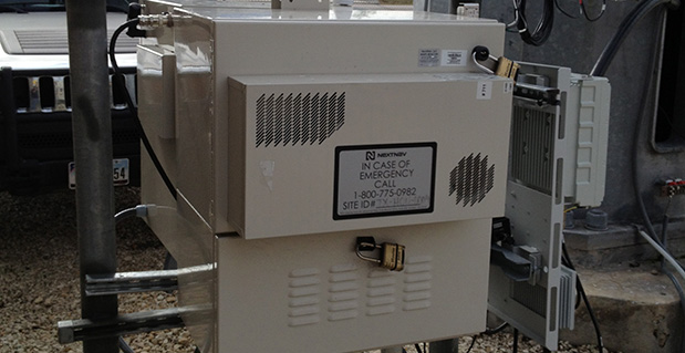
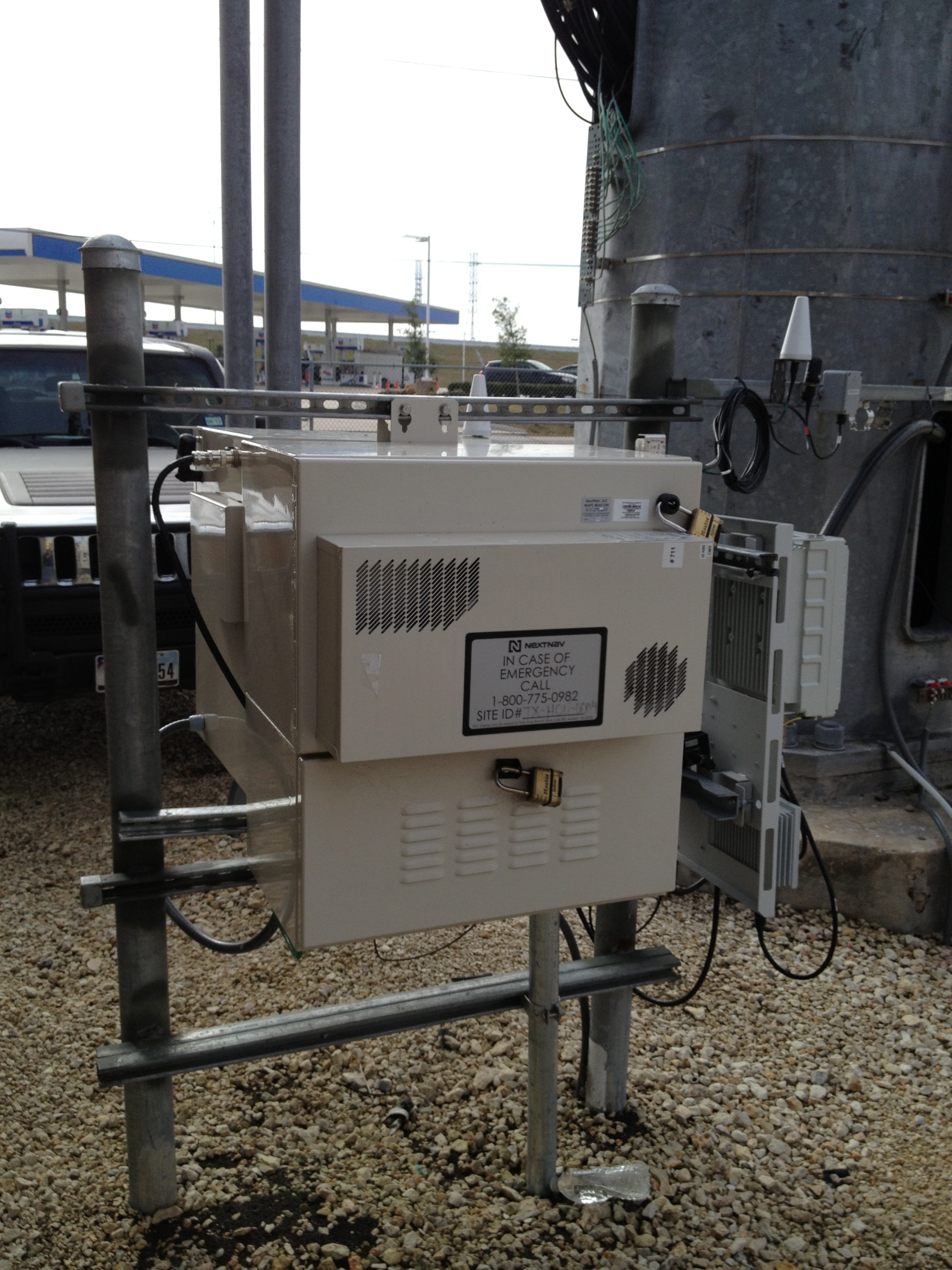
On October 2, NextNav announced that Broadcom Corporation acquired a commercial license to NextNav’s Metropolitan Beacon System (MBS) technology, a so-called terrestrial constellation that brings GNSS-like performance to indoor and urban environments where satellite-based positioning is either unavailable or significantly degraded.
The agreement enables Broadcom to integrate NextNav’s location technology into its mass-market GNSS connectivity and mobility platforms, used primarily in cell phones and tablets.
NextNav President and Founder Ganesh Pattabiraman characterized the deal in a conversation with GPS World: “This is a commercial license to a Tier 1 chipset provider, whose products are in a vast number of smart and feature phones in the country. The partnership enables our technology in a low-cost, high-volume form factor. This is important for us since we don’t make chips. We rely on partners such as Broadcom. This is the first of many such agreements; we’ll have more through the year.”
Most wireless companies have a mobility group addressing cellular modems, the central clearinghouse for so-called connectivity: the combination of Wi-Fi, Bluetooth, GNSS, and other technologies. Standard assisted GNSS (A-GNSS) packages to date in such cases generally consist of ephemeris from all GNSS satellite constellations supported by the wireless company’s chips, cell ID and Wi-Fi ID from base-station databases, and additional proprietary assistance mechanisms.
The NextNav MBS concept shares many operating principles with GNSS satellite constellations, but because the NextNav beacons are installed terrestrially instead of in space, they transmit sufficient signal strength for reliable reception indoors and in urban canyons where a clear view of the sky is unavailable. MBS is deployed much like a cellular network, to provide consistent indoor positioning to every building within a covered metropolitan area. MBS offers both accurate horizontal positioning and highly accurate altitude information, a particularly important capability for emergency responders in urban and indoor areas where GNSS systems tend to be most challenged.
NextNav built its MBS network across forty large U.S. markets (see list at end of story) with its own Federal Communications Commission (FCC) licensed spectrum. “We bring more a managed network providing consistency and reliability of position information,” continued Pattabiraman. “Also the vertical component that other systems do not provide.” He characterized Wi-Fi, for example, as “an unmanaged network,” subject to frequent changes without a centralized and continually updated source of certified data.
NextNav location performance was recently highlighted in side-by-side technology tests conducted by the Communications Security, Reliability, and Interoperability Council (CSRIC) of the FCC, and published in March of this year; see reportage and analysis of these tests at The Inner Edge: Who Holds the Key to Indoor Nav?
The trial compared the performance of location systems across urban, suburban, and rural areas in the San Francisco Bay Area for determining the location of callers during emergency calls (E911), a critical case for mobile-phone users. NextNav was the only technology capable of reporting a valid height or altitude estimate, enabling floor-level positioning. NextNav’s horizontal accuracy results also reduced first-responder “search rings” by 90 percent over its nearest competitor.
Don Fuchs, director of business development at Broadcom, added “Nextnav is a metropolitan area location system, which is typically a wider area than that covered by Wi-Fi. Wireless emergency assistance calling (E911) needs a wider venue covered. And across 40 metro areas. Nextnav is wide area, while Wi-Fi is essentially local area.”
Pattabiraman said that in a typical metro area, NextNav’s terrestrial constellation of beacons is deployed for maximum coverage and minimum GDOP, and is not constrained by capacity like a cellular network. He stated that the San Francisco Bay area covered by NextNav extends to 900 square miles, from South San Jose into Marin County and East Bay. “With a fraction of the beacons required for cellular coverage in the same area, which would be in the neighborhood of a few thousand antenna installations, our deploy and operating costs are much less. Less than 20 percent of that for a cellular network.”
In comparison with Locata, another recently rolled out terrestrial constellation designed to fill GNSS gaps, Pattabiraman said, “Locata and NextNav are two entirely different systems serving different needs. We are in the mass-market commercial cell phone wide area use case, filing that gap, providing 5–10 meter accuracy, with vertical as a critical component, and full market coverage.Locata covers centimeter-level precision application in localized environments. The two companies could both eventually get to the other side [of the market-sector spectrum], but currently each of us is focused on the particular requirements of our designated market areas.Also, we operate with licensed spectrum versus the Locata operation in 2.4 GHz unlicensed.”
“At the highest level, they are both multi-lateration systems. Time of arrival, time difference of arrival. We arrive at our core synchronization via GPS, which has its own synchronization, but we’ve got our IP on top of that to improve it. Each beacon is autonomous. You can drop it anywhere with a clear view of the sky, and it is synchronized to the rest of the network, it has its own self-synchronizing mechanisms. Locata is a synchronized network.
“Another way of looking at it, they have a replacement for GPS. We do more complementing for GPS, we count on GPS being there.”
Broadcom’s Fuchs added, “From the perspective of a company designing GPS and GNSS client-side semiconductors, we view NextNav as a terrestrial constellation, no more difficult or challenging than adding support for any new or legacy constellation like BeiDou or GLONASS. We see this integration as being very straightforward, we have lots of IP in the area of signal processing, these sort of signals, this sort of positioning algorithm. We add NextNav as a secondary technology for challenging urban conditions. We view this as a piece of location technology to develop and integrate as the market demands.
“In six years at Broadcom and seven before that at Global Locate (acquired by Broadcom in 2007), we have a history of turning support like this, we’ve been able to do this very quickly. Depending on market demand, in less than a year. I can’t lay out a roadmap at this point. We expect to see market demand for this, certainly expect regulatory demand. We wanted to get to the point where we can react to that in less than a year. That was the motivation to get this agreement into place, and we are now positioned.”
“We all operate under standard operating environments as specified by the FCC. We’re metro-wide just like paging towers or broadcast TV,” continued Pattabiraman. “We’re not necessarily doing anything different as regards the indoor environment. We’re not adding anything additional to the noise spectrum or floors. Our maximum transmission is 30 watts, very small compared to cell transmission in kilowatts. It is bits per second by the time it hits the receiver. Because it’s calibration for navigation, the network design is optimized for location. We take into account GDOP and coverage, maximizing the latter, minimize the former. There is a very low throughput. It’s a tradeoff between power and coding. We code the heck out of this thing. We just new a few bits to get our information through, not like cellular that needs to get megabits through.”
As to any data or issues about the human health impacts of an RF-rich indoor environment, Pattabiraman concluded, “There’s none of this concern about power into your head. We transmit only at the tower, receive only at the user. It is very, very heavily coded, like GPS, and very low-powered. It’s not even close [to cell transmission power]. We’re a feather, they’re a hammer.”
List of NextNav Covered Metro Areas
NextNav characterizes San Francisco as built to “commercial grade” and the other markets as “Initial Builds.”
Boston-Worcester-Lawrence, ME
Syracuse, NY-PA
New York-North New Jersey, NY-NJ
Philadelphia-Wilmington-Atlantic City, PA-NJ-DE-MD
This year, ION GNSS+ was once again in Nashville, Tennessee — with around 1,050 attendees and 63 exhibitors, show attendance was down from last year, maybe because of a reduced military presence and more constrained government budgets. But the conference was a good one. The CGSIC (Civil GPS Service Interface Committee) ran just before the ION conference, and provided an opportunity for better visibility of the ins and outs of the GPS program and enabled a degree of U.S. military-commercial exchange.
On Tuesday, CGSIC gave us an overview of the Navigation & Timing exhibit at the National Aerospace Museum in Washington, D.C., an insight into news of the evolving U.S. government’s PNT policy, State Department international activities (including estimates of GPS contributing $68-122 billion and 3.3 million jobs to the U.S. economy), a Homeland Security update on interference detection and enforcement, and of course the regular GPS Directorate program updates from the Air Force. Then we had subcommittee reports from various sectors, including timing, survey, and from the Federal Aviation Administration (Distance Measuring Equipment, or DME, is apparently the FAA’s chosen back-up for GPS in the National Airspace System). Finally, the GPS Directorate chief engineer provided an overview of GPS R&D activities and an opportunity for civilian attendee feedback and input.
The lone commercial presenter — Eric Gakstatter, a fellow contributor to GPS World — proposed that the Air Force make “PRED” (predicted ephemeris, regularly produced by the Air Force GPS system, but not available to commercial users) be unclassified and released for civilian use.
Both Broadcom and Rx Networks commented that they provide predicted ephemeris to their users, and post conference I let Eric know that Baseband Technologies has a software product providing predicted ephemeris which is good for 28 days without any intermediate updates. The Air Force said it would think about releasing PRED, but there seemed to be significant issues to doing that.
The ION GNSS+ conference got going on the Wednesday morning, with a whole slew of technical papers, panel sessions, and the opening of the exhibition floor. The papers tend to be quite technical and sometimes quite academic — for example, “Approaches to Obtaining Beidou Hazardous Bias with Ordered Weighted Aggregation Operators” — but these quite detailed presentations is what a subset of ION GNSS+ attendees come for, and they want to hear the results of the very latest research. One “technical session” allowed manufacturers to provide announcements and summaries of their new products and systems — a welcome opportunity for commercial and technical attendees alike. ION has also instituted panel sessions, which deal with more global subjects — for example, Program Updates or High Integrity Systems (such as WAAS), which tend to draw equal attention from a good number of attendees.
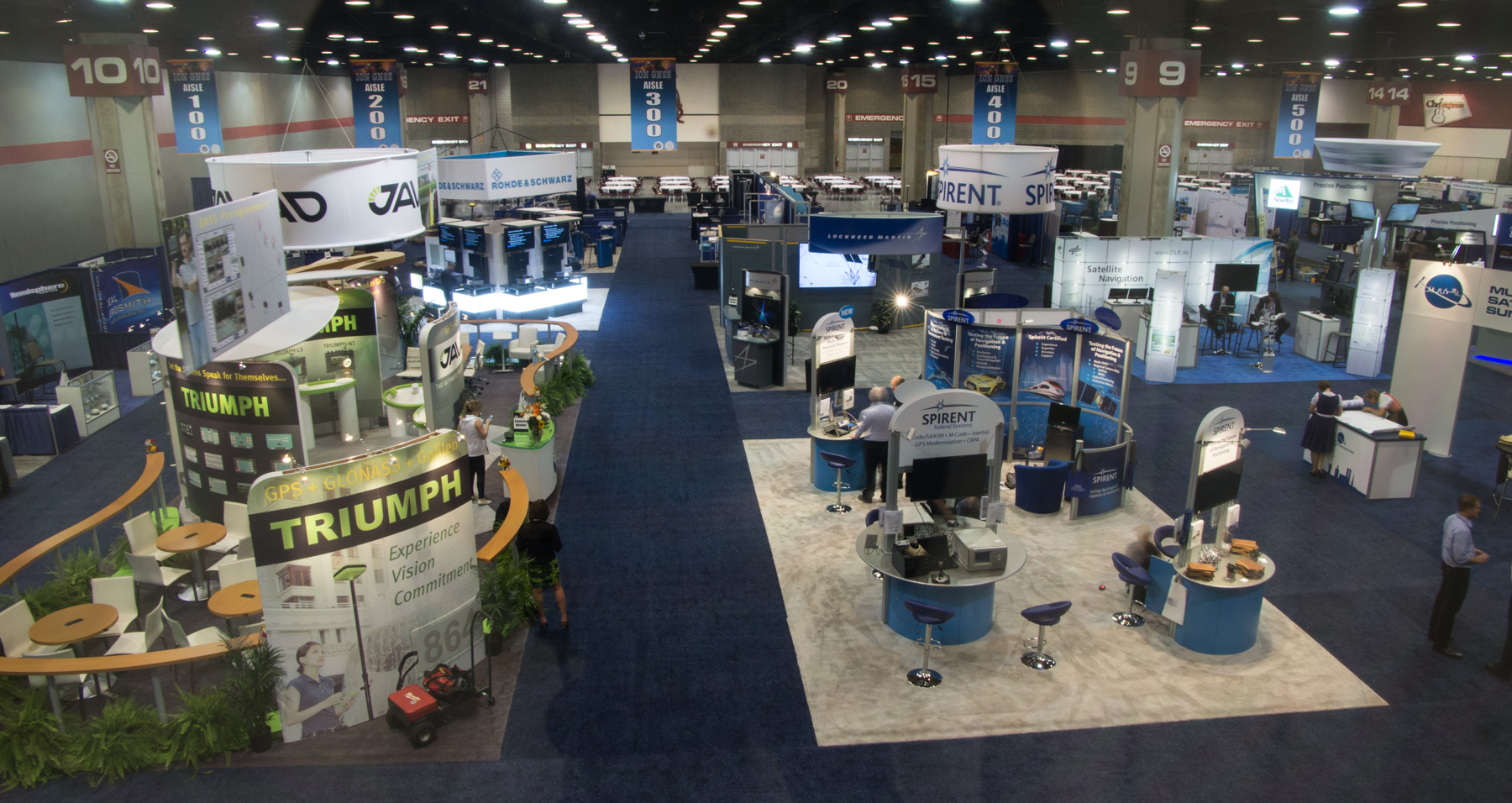
The ION GNSS+ 2013 show floor.
The show floor always seems to be the highlight of the conference, however, and its often packed at times when papers or panels are not running. With around 63 exhibitors this year, it seemed a little smaller than last year, but there were also a number of new companies with booths.
Panel Sessions
Panel sessions I sat in on included Program Updates, some of New Products, and High Integrity Systems. Program updates were provided by GPS, GLONASS, Galileo, Beidou, and QZSS:
GPS URE (pseudorange inaccuracy due to ephemeris and clock errors) is running around 80 cm and was 47 cm at one time recently, versus a “promise” of 4 meters for civil users. The average age of the older IIA satellites (SVs) is currently running around 2-2.5 time design life, and as the newer generation of satellites (SVs) comes on line, URE is expected to continue to drop.
GLONASS is performing up to expectations and is relatively stable, despite the odd jump in URE which is apparently due mostly to ground control issues. The loss of three SVs in the July Proton launch failure was a setback, but with several SVs built and in storage, Russia anticipates resuming the replenishment schedule soon. They will get to orbit mostly using Soyuz launchers, and a few Protons. There is a commitment to launch new SVs with CDMA (time division format, as per all other GNSS) on L3, while maintaining existing FDMA (unique GLONASS frequency format) signals and, indeed, one GEO SV is apparently already on orbit transmitting an L3 CDMA test signal. GLONASS has the objective of achieving 60 cm URE by 2020.
Galileo is moving along with four SVs on orbit and initial fixes achieved with both commercial and government PRS signals; 22 FOC (production) SVs are now ordered, and 16 ground reference stations and five uplink stations stations are up and running. Significant effort is anticipated on the next phases of Galileo and EGNOS, and a €6 billion budget for this work has been approved.
Beidou apparently has 14 operational SVs right now, which is adequate for regional coverage of China, but work is intended to continue towards a global constellation of five GEOs and 30 non-GEO SVs. Work is also shortly intended on a Wide Area Differential Service, chipsets are already available for receivers, and site surveys are planned for offshore reference stations. A five-year plan has been approved, and the next launch is possibly in 2014 for testing of the global (MEO) constellation.
Michibiki cartoon.
QZSS has successfully proven the concepts of operation with the first Michibiki satellite, and Japan has ordered the remaining three SVs for the constellation. The ground network contact was also let in March 2012.The intention is to achieve sub-meter service on L1 C/A, and the CLAS augmentation system is targeted to provide a ~10 cm service.
The New Products panel had way too much academic and agency content for me and virtually no commercial new products content, so quite disappointing.
The High-Integrity (WAAS-systems) panel was much more interesting for a guy who used to live in this space:
WAAS has achieved LPV-200 (aircraft landing ~200ft decisions height) across the U.S., including Alaska in 2013, and RNP 0.3 (positioning within 0.3 nautical miles) across the whole of North America and a good portion of South America. Plans are moving forward with the introduction of L5 into WAAS. If Initial Operational Capability (IOC) for GPS L5 is 2021, then WAAS IOC for L1/L5 capability should be two years later — also replacement of obsolescent elements, and doubling the comms network bandwidth.
EGNOS has another Version 3 future evolutionary stage planned, with more RIMS (reference stations) planned, and possible expansion into Africa is on the table.
MSAS has not got to the operational accuracy it wanted yet, but with the current two MTSAT GEOS, RNP 0.3 is available over Japan and area. Ten more reference sites are needed to get to LPV-200, but there is no budget yet allocated.
Gagan now has two GEOs (GSAT-8 and 10) and achieves RNP 0.1 over India and anticipates operational certification by 2014.
SDCM (Russia) is anticipated to be in place by 2016 for L1, and by 2018 expects to add L5. Currently working some interference issues between the second SDCM GEO (Luch-5B) and an Inmarsat GEO at 15.5 ̊ West, the contact for the SDCM ground network is anticipated before the end of this year, and a heavier (five-ton) GEO (called Enisey) is planned for the 95 ̊ Eastslot in 2017/18. This will carry not only L1, but also L5 and L3, both CDMA signals. There was a lot of interest at ION in when the GLONASS CDMA L3 signal would be fielded in the GLONASS constellation — no real predictions for when, but the L3 ICD release should be “before the next GLONASS K launch.”
Exhibit Hall
The exhibition was indeed a little smaller than last year, but there was plenty of activity on the floor. Most people I talked with had new products at the show, or had new information they were eager to discuss:
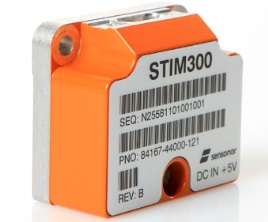
STIM300 MEMS Sensor.
Sensonor (Norway)has joined up with NovAtel,who is now offering its STIM300 MEMS inertial sensor as part of the NovAtel SPAN family. Sensonor apparently has a number of installs on unmanned aerial vehicles (UAVs).
Sysnav (France) has a sensor that cleverly uses Magnetic Variation with MEMS to do fairly accurate positioning in the absence of GNSS signals. Sysnav was looking for partners in North America.
Javad had his usual extensive line of surveying instruments, but his latest OEM receiver showed up with 864 channels! With three processors, program memory, multi-constellation (everything!) and monster channel tracking (100 of which scan for GNSS interference), this by far had the greatest receiver capacity at the show.
Trimble announced its latest tiny BD930 RTK capable OEM receiver — supporting both triple-frequency GPS and GLONASS, plus dual-frequency Beidou and Galileo. And it’s completely enclosed in an RF screening “can.”
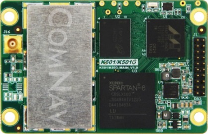
ComNav (China) showed up with a series of multi-frequency, GPS/Beidou/GLONASS RTK-capable OEM receivers, packaged receivers, and antennas. With 100 people based in Shanghai, ComNav claims to have captured 30% of the Chinese market, selling 15,000 receivers — derived from technology developed by Dr. Wong Yong Quan. Impressive capability on display — also seeking distribution in North America.
Surrey Satellite (UK) are apparently working on a number of R&D projects alongside building the nav payloads for the Galileo FOC SVs. TechDemoSat-1 is an innovative UK technology platform that includes a GPS reflectometry experiment to measure wave intensity for marine weather services. Apparently there is little weather information for large areas of the world’s oceans, and this may help to solve a major marine nav issue.
Nottingham University (UK) is working on predictive integrity for UAVs. GNSS signal outage/degradation in flight, caused by antenna obscuration, multipath, fading due to adverse geometry and Doppler shift, are critical for UAVs. Nottingham modeling is aimed at real-time avoidance of safety-critical flight conditions and fast recovery of navigation performance following GNSS data losses.
Trusted Positioning (Canada) is moving quickly down the indoor location path and has some neat software integration solutions for cell phones using signals of opportunity, pressure sensors and MEMS. The company sees the initial market being for things like mapping indoor locations, iteratively improving positioning, and location-based advertising.
Spirent GSS6425 record and playback system.
Spirent has released the GSS6425, which is a highly portable simulation system for recording live GPS L1/L2/L5, GLONASS L1/L2/L3, BeiDou-2 B1/B2, Galileo E1/E5, QZSS L1/L2/L5 and SBAS signals in the field — for repeated replay in the lab. BeiDou has been introduced across the Spirent simulation product line, and Spirent released information on sophisticated spoofing simulation.
IFEN (Germany) is also working on spoofing, has added BeiDou B1 and B2 signals, has added a four multi-RF output capability, and is working on automotive gyro and odometer testing capability.
R&S DDF007 Portable I/F Direction Finder.
Rohde & Schwarz had an extensive display of capability alongside its SMBV 100A GNSS simulator. An impressive array of spectrum analyzers and generators, with one set-up catching my eye — the DDF007 portable interference detection system used by government agencies for tracking down jammers.
I didn’t get to everyone’s booth, and I just didn’t have the space to cover everything, but I’d call this a reasonable cross section of the exhibitors; to some degree its a summary of the panels and includes some of the corridor discussions typical of ION.
So, I would call this another successful ION show, and I’m looking forward to next year’s ION GNSS+ conference in my neck of the woods in Tampa, Florida, in September. It would seem that the interest level remains high across academia, agencies and industry — but those of us who may still want to see new business as payback for the investment of attending and/or exhibiting, I think we would have preferred still more commercial content.
ION remains a place to meet and greet customers and people working across multiple market segments, where system providers can brief us and mix with users, and the intensity of technology development and research can be shared and sampled. It’s still an invaluable place to visit once a year if you are connected in any way to the GNSS industry and community.
GPS World contributing editor Eric Gakstatter gave a talk on predicted ephemeris at the Civil GPS Service Interface Committee (CGSIC) on Tuesday. The talk was invited and the topic was suggested by CGSIC coordinators. The 53rd meeting of the CGSIC was held Monday and Tuesday before the Institute of Navigation GNSS+ 2013 Conference. Here is Eric’s talk:
Whenever I point a critical finger at the GPS folks, I apologize before I do so because it’s really a wonderful system.
What I try to offer the community in general is a link between the GPS system operators and the civil community. It’s amazing when you think about it, two huge user bases of civil and military users, and a little strip called CGSIC that communicates between them. Rick [Hamilton of CGSIC] introduced me to this concept a couple months ago and asked me to investigate it and think about it. This is what I researched and talked to some folks and came up with.
First, I want to introduce you to some folks doing fascinating things with GPS.
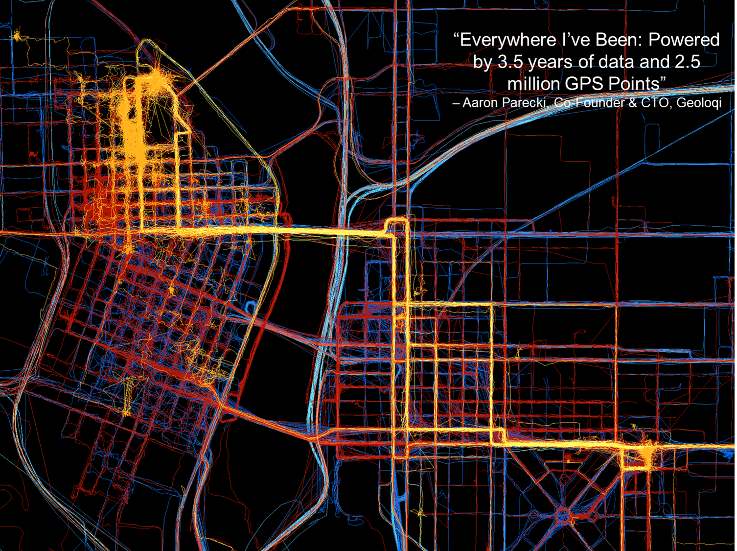
Here’s a young company, Geoloqi, doing really interesting things in Portland. They don’t have any clue where GPS came from; they just have it on their smartphones. One of the founders collected GPS data everywhere he went for the last three and a half years. This map shows 2.5 million data points, and I think it’s fascinating.
This map of Portland by Geoloqi has 2.5 million data points.
These folks interface between the GPS chipset in the mobile device and the apps that run on it. They sold their company to Esri last year.
“Geolocation has the potential to become an indispensable part of our lives. But to be a valuable service, the technology needs to be invisible yet opted into, private, and secure.” — Amber Case, Geoloqi founder
These kids just want to get things done, create ideas and create products: things like, check into a hotel when you get within 100 yards of the door; get your prescription prepared and ready for you when you come within a certain distance of a pharmacy. All these kinds of things are based on the geotrigger or geofence concept.
Now, talking about my work, primarily in surveying and mapping, with companies like utilities with 15 million customers and a lot of infrastructure. To put that at the fingertips of a maintenance person, that’s pretty amazing. I’ve been swimming in this soup for a long time, and I hadn’t heard of this concept — the predicted ephemeris (PRED) produced by GPSOC.
Take a PRED state vector data file, which is currently generated every 15 minutes by the GPS Operations Center under For Official Use Only (FOUO), currently designated unclassified, but not accessible to the general public. If it were made available for public use, it could decrease time to first fix from 40 seconds when you turn on your mobile device, to 5 to 10 seconds.
In the high-precision field like mine, surveying, it really doesn’t make too much difference because by the time you get out of your truck and set up your gear, 30 seconds has already gone by and it doesn’t make much difference.
Now it could be more of an issue with mobile devices in GPS-impaired environments such as urban canyons or indoor environments, where 30 seconds could make the difference between getting a fix or not.
If predicted ephemeris were available, developers could distribute it terrestrially via a wireless network to mobile devices.
Problem: How to transfer PRED from a U.S. government FOUO environment to make it available to application developers?
To me as a product developer or a product manager, interested in pushing products out to the community, that’s a really small speed bump. But when I talk to colleagues who operate in that (government) space, that’s a significant undertaking, a real obstacle. We’re talking about a big change, and a big process to go through to effect that change.
PRED from the horse’s mouth, so to speak, from the U.S. Air Force, really builds credibility. I can build it into a product, because I know it’s going to be there three or four or more years from now.
PRED can be made available, but Civil GPS app developers need to speak up — because civil users won’t. They don’t know about it. They don’t know what is possible.
“How does somebody know what they want if they haven’t even seen it?” — Steve Jobs
I’m trying to raise awareness here. I’ll probably write about soon in the magazine or in my [Survey Scene] email newsletter.
Frank van Diggelen, Broadcom. We’ve been doing this in the commercial world for over a decade. You all have it in your cellphones, with about 90% likelihood provided by Broadcom or someone who’s licensed our patents. It doesn’t work properly unless you have the source of the data and the client side working very cooperatively. The issue is the . . . gap between prediction and use. If the satellite is moved (in orbit or clock) then the prediction is wrong, and you need client-side software that is design cooperatively with the predictions. Our predictions are available in 2-, 4-, 7- or 30- day intervals. Think of a use case where you get a seven-day prediction, and then go away from network coverage for several days, meanwhile, say on Day 4, a satellite is moved or has its clock adjusted, on Day 5 it is set healthy, on Day 6 you turn on your handset and use the prediction from six days ago — it will be wrong and your client-side software has to catch that and know know how to invalidate the predictions.
We deliver these orbital predictions at about the rate of a billion per month. It’s been there for 10 years, and its been working so well most people aren’t even aware that it’s there. If the Air Force puts these out, that sounds great, but if you don’t have client-side software looking for erroneous predicitions — when a satellite is adjusted or moved — then things would be a lot worse for the user community than they have for the last 10 years.
Eric Gakstatter: I understand that, but that’s true for any technology. If a company implements it incorrectly, the market will reject it. Let the market decide.
There may be a need for a non-proprietary solution (PRED) that is publicly available so it could be implemented by other developers, and level the playing field to increase market adoption of GPS.
Broadcom Corporation introduced at the Mobile World Congress a highly integrated digital baseband processor and RF transceiver designed for 3G femtocell residential access points, the BCM61630 systems on chip. The Mobile World Congress is being held in Barcelona, Spain, this week.
The new devices integrate a multiband CMOS RF transceiver with GPS and full-time sniffing capability while maintaining software compatibility with all previous Broadcom WCDMA physical layer and backhauling interface architectures.
With the new chips, mobile operator OEMs and ODMs have a powerful, low-cost, power efficient device to support small cell strategies and meet growing mobile traffic demands. Embedding a high-speed CPU and Broadcom’s Layer 1 modem and peripherals, these devices provide a complete low-power single-chip solution for residential and small enterprise 3G small cell deployments, the company said.
“As on-the-go content consumption continues to drive traffic growth, mobile operators must meet consumers’ increasing demand for higher bandwidth without sacrificing quality of service,” said Greg Fischer, Broadcom’s vice president and general manager for Broadband Carrier Access. “Broadcom’s BCM61630 SoCs deliver a low-power, cost-efficient device for residential small cells to leverage existing mobile infrastructure and deliver faster data speeds through a smaller form factor.”
In December 2011, Grizzly Analytics released its first comprehensive report on indoor location positioning technology, predicting that indoor location services were ready to revolutionize the mobile market. The five months that followed have shown how true this was, with new initiatives announced on a regular basis and numerous demonstrations at industry conferences, Grizzly Analytics says.
In a fully revised and updated 163-page report, Grizzly Analytics gives an up-to-date analysis and comprehensive overview of indoor location positioning R&D. Included is information on the research activity of all the major mobile companies — Google, Microsoft, Samsung, Apple, Nokia, RIM, Cisco, Qualcomm, Broadcom, STMicroElectronics, Sony Ericsson and others — and also more than 30 start-up companies that are actively bringing indoor location services to market.
“These technologies are poised to revolutionize smartphone usage by enabling GPS-style mapping, navigation, local search, check-ins, location-sharing and other location-based services to work indoors in malls, megastores, offices, airports, casinos and other big indoor places,” according to a statement by Grizzly Analytics. “Indoor location will also transform commerce, enabling searching for items on store shelves, sending deals and promotions to nearby customers, advertisements for nearby stores in malls, and more. Location services are also entering the enterprise, with indoor asset tracking, employee search, and more.
“In this updated technology trend report, Indoor Location Positioning: Research Pipelines, Start-ups and Predictions, Grizzly Analytics answers the questions you have about this new technology. What approaches are being researched by different companies? Which companies have mature research? What are the gaps in each company’s research that they are likely to fill by acquiring start-up companies? Which start-up companies are likely to be acquired or to emerge successful in the market? What areas of technology are not yet addressed by start-ups, and remain open to new entrepreneurs and investors?”
Seven technologies that put GPS in mobile phones around the world — the how and why of location’s entry into modern consumer mobile communications.
By Frank van Diggelen, Broadcom Corporation
Exactly a decade has passed since the first major milestone of the GPS-mobile phone success story, the E-911 legislation enacted in 1999. Ensuing developments in that history include:
Snaptrack bought by Qualcomm in 2000 for $1 billion, and many other A-GPS startups are spawned.
Commercial GPS receiver sensitivity increases roughly 30 times, to 2150 dBm (1998), then another 10 times, to 2160 dBm in 2006, and perhaps another three times to date, for a total of almost 1,000 times extra sensitivity. We thought the main benefit of this would be indoor GPS, but perhaps even more importantly it has meant very, very cheap antennas in mobile phones. Meanwhile:
Host-based GPS became the norm, radically simplifying the GPS chip, so that, with the cheap antenna, the total bill of materials (BOM) cost for adding GPS to a phone is now just a few dollars!
Thus we see GPS penetration increasing in all mobile phones and, in particular, going towards 100 percent in smartphones.
This article covers the technology revolution behind GPS in mobile phones; but first, let’s take a brief look at the market growth. This montage gives a snapshot of 28 of the 228 distinct Global System for Mobile Communications (GSM) smartphone models (as of this writing) that carry GPS.
Back in 1999, there were no smartphones with GPS; five years later still fewer than 10 different models; and in the last few years that number has grown above 200. This is that rare thing, often predicted and promised, seldom seen: the hockey stick!
The catalyst was E-911 — abetted by seven different technology enablers, as well as the dominant spin-off technology (long-term orbits) that has taken this revolution beyond the cell phone.
In 1999, the Federal Communications Commission (FCC) adopted the E-911 rules that were also legislated by the U.S. Congress. Remember, however, that E-911 wasn’t all about GPS at first.
It was initially assumed that most of the location function would be network-based. Then, in September 1999, the FCC modified the rules for handset technologies. Even then, assisted GPS (A-GPS) was only adopted in the mobile networks synchronized to GPS time, namely code-division multiple access (CDMA) and integrated digital enhanced network (iDEN, a variant of time-division multiple access).
The largest networks in the world, GSM and now 3G, are not synchronized to GPS time, and, at first, this meant that other technologies (such as enhanced observed time difference, now extinct) would be the E-911 winners. As we all now know, GPS and GNSS are the big winners for handset location. E-911 became the major driver for GPS in the United States, and indirectly throughout the world, but only after GPS technology evolved far enough, thanks to the seven technologies I will now discuss.
Technology #1. Assisted GPS
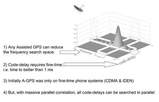
There are three things to remember about A-GPS: “faster, longer, higher.” The Olympic motto is “faster, stronger, higher,” so just think of that, but remember “faster, longer, higher.”
The most obvious feature of A-GPS is that it replaces the orbit data transmitted by the satellite. A cell tower can transmit the same (or equivalent) data, and so the A-GPS receiver operates — faster.
The receiver has to search over a two-dimensional code/frequency space to find each GPS satellite signal in the first place. Assistance data reduces this search space, allowing the receiver to spend longer doing signal integration, and this in turn means higher sensitivity (Figure 1). Longer, higher.
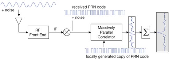
FIGURE 1. A-GPS: reduced search space allows longer integration for higher sensitivity.
Now let’s look at this code/frequency search in more detail, and introduce the concepts of fine time, coarse time, and massive parallel correlation. Any assistance data helps reduce the frequency search. The frequency search is just as you might scan the dial on a car radio looking for a radio station — but the different GPS frequencies are affected by the satellite motion, their Doppler effect. If you know in advance whether the satellite is rising or setting, then you can narrow the frequency-search window.
The code-delay is more subtle. The entire C/A code repeats every millisecond. So narrowing the code-delay search space requires knowledge of GPS time to better than one millisecond, before you have acquired the signal. We call this “fine-time.”
Only two phone systems had this time accuracy: CDMA and iDEN, both synchronized to GPS time. The largest networks (GSM, and now 3G) are not synchronized to GPS time. They are within 62 seconds of GPS time; we call this “coarse-time.” Initially, only the two fine-time systems adopted A-GPS. Then came massive parallel correlation, technology number two, and high sensitivity, technology number three.
#2, #3. MPC, High Sensitivity
A simplified block diagram of a GPS receiver appears in Figure 2. Traditional GPS (prior to 1999) had just two or three correlators per channel. They would search the code-delay space until they found the signal, and then track the signal by keeping one correlator slightly ahead (early) and one slightly behind (late) the correlation peak. These are the so-called “early-late”correlators.
FIGURE 2. Massive parallel correllation.
Massive parallel correlation is defined as enough correlators to search all C/A code delays simultaneously on multiple channels. In hardware, this means tens of thousands of correlators. The effect of massive parallel correlation is that all code-delays are searched in parallel, so the receiver can spend longer integrating the signal whether or not fine-time is available.
So now we can be faster, longer, higher, regardless of the phone system on which we implement A-GPS.
Major milestones of massive parallel correlation (MPC):
In 1999, MPC was done in software, the most prominent example being by Snaptrack, who did this with a fast Fourier transform (FFT) running on a digital signal processor (DSP). The first chip with MPC in hardware was the GL16000, produced by Global Locate, then a small startup (now owned by Broadcom).
In 2005, the first smartphone implementation of MPC: the HP iPaq used the GL20000 GPS chip. Today MPC is standard on GPS chips found in mobile phones.
#4. Coarse-Time Navigation
We have seen that A-GPS assistance relieves the receiver from decoding orbit data (making it faster), and MPC means it can operate with coarse-time (longer, higher).
But the time-of-week (TOW) still needed to be decoded for the position computation and navigation: for unambiguous pseudoranges, and to know the time of transmission. Coarse-time navigation is a technique for solving for TOW, instead of decoding it. A key part of the technique involves adding an extra state to the standard navigation equation, and a corresponding extra column to the well known line-of-sight matrix.
The technical consequence of this technique is that you can get a position faster than it is possible to decode TOW (for example, in one, two, or three seconds), or you can get a position when the signals are too weak to decode TOW. And a practical consequence is longer battery life: since you can get fast time-to-first-fix (TTFF) always, without frequently waking and running the receiver to maintain it in a hot-start state.
#5. Low Time-of-Week
A parallel effort to coarse-time navigation is low TOW decode, that is, lowering the threshold at which
it is possible to decode the TOW data. In 1999, it was widely accepted that -142 dBm was the lower limit of signal strength at which you could decode TOW. This is because -142 dBm is where the energy in a single data bit is just observable if all you do is integrate for 20 ms.
However, there have evolved better and better ways of decoding the TOW message, so that now it can be done down to -152 dBm. Today, different manufacturers will quote you different levels for achievable TOW decode, anywhere from -142 to -152 dBm, depending on who you talk to. But they will all tell you that they are at the theoretical minimum!
#6, #7. Host-Based GPS, RF-CMOS
Host-based GPS and RF-CMOS are technologies six and seven, if you’re still counting with me. We can understand the host-based architecture best by starting with traditional system-on-chip (SOC) architecture. An SOC GPS may come in a single package, but inside that package you would find three separate die, three separate silicon chips packaged together: A baseband die, including the central processing unit (CPU); a separate radio frequency tuner; and flash memory. The only cost-effective way of avoiding the flash memory is to have read-only memory (ROM), which could be part of the baseband die — but that means you cannot update the receiver software and keep up with the technological developments we’ve been talking about. Hence state-of-the-art SOCs throughout the last decade, and to date, looked like Figure 3.
FIGURE 3. Host-based architecture, compared to SOC.
The host-based architecture, by contrast, needs no CPU in the GPS. Instead, GPS software runs on the CPU and flash memory already present on the host device (for example, the smartphone). Meanwhile, radio-frequency complementary metal-oxide semi-conductor (RF-CMOS) technology allowed the RF tuner to be implemented on the same die as the baseband. Host-based GPS and RF- CMOS together allowed us to make single die GPS chips.
The effect of this was that the cost of the chip went down dramatically without any loss in performance.
Figure 4 shows the relative scales of some of largest-selling SOC and host- based chips, to give a comparative idea of silicon size (and cost). The SOC chip (on the left) is typically found in devices that need a CPU, while the host-based chip is found in devices that already have a CPU.
FIGURE 4. Relative sizes of host-based, compared to SOC.
In 2005, the world’s first single-die GPS receiver appeared. Thanks to the single die, it had a very low bill of materials (BOM) cost, and has sold more than 50 million into major-brand smartphones and feature phones on the market.
Review
We have seen that E-911 was the big catalyst for getting GPS into phones, although initially only in CDMA and iDEN phones. E-911 became the driver for all phones once GPS evolved far enough, thanks to the seven technology enablers:
A-GPS >> faster, longer, higher
Massive parallel correlation >> longer, higher with coarse-time
High-sensitivity >> cheap antennas
Coarse time navigation >> fast TTFF without periodic wakeup
Low TOW >> decode from weak signals
Host-based GPS, together with
RF-CMOS g single die.
Meanwhile, as all this developed, several important spin-off technologies evolved to take this technology beyond the mobile phone. The most significant of all of these was long-term orbits (LTO), conceived on May 2, 2000, and now an industry standard.
Long-Term Orbits
Why May 2, 2000? Remember what happened on May 1, 2000: the U.S. government turned off selective availability (SA) on all GPS satellites. Suddenly it became much easier to predict future satellite orbits (and clocks) from the observations made by a civilian GPS network. At Global Locate, we had just such a network for doing A-GPS, as illustrated in Figure 5. On May 2 we said, “SA is off — wow! What does that mean for us?”And that’s where LTO for A-GPS came from.
FIGURE 5. Broadcast ephemeris and long-term orbits.
Figure 5 shows the A-GPS environment with and without LTO. The left half shows the situation with broadcast ephemeris only. An A-GPS reference station observes the broadcast ephemeris and provides it (or derived data) to the mobile A-GPS receiver in your mobile phone. The satellite has the orbits for many hours into the future; the problem is that you can’t get them.
The blue and yellow blocks in the diagram represent how the ephemeris is stored and transmitted by the GPS satellite. The current ephemeris (yellow) is transmitted; the future ephemeris (blue) is stored in the satellite memory until it becomes current. So, frustratingly, even though the future ephemeris exists, you cannot ordinarily get it from the GPS system itself.
The right half of the figure shows the situation with LTO. If a network of reference stations observes all the satellites all the time, then a server can compute the future orbits, and provide future ephemeris to any A-GPS receiver. Using the same color scheme as before, we show here that there are no unavailable future orbits; as soon as they are computed, they can be provided. And if the mobile device has a fast-enough CPU, it can compute future orbits itself, at least for the subset of satellites it has tracked.
Beyond Phones. This idea of LTO has moved A-GPS from the mobile phone into almost any GPS device. Two of most interesting examples are personal navigation devices (PNDs) in cars, and smartphones themselves that continue to be useful gadgets once they roam away from the network. Now, of course, people were predicting orbits before 2000 — all the way back to Newton and Kepler, in fact. It’s just that in the year 2000, accurate future GPS orbits weren’t available to mobile receivers. At that time, the International GNSS Service (IGS) had, as it does now, a global network of reference stations, and provided precise GPS orbits organized into groups called Final, Rapid and Ultra-Rapid. The Ultra-Rapid orbit had the least latency of the three, but, in 2000, Ultra-Rapid meant the recent past, not the future.
So for LTO we see that the last 10 years have taken us from a situation of nothing available to the mobile device, to today where these long-term orbits have become codified in the 3rd Generation Partnership Project (3GPP) and Secure User Plane Location (SUPL) wireless standards, where they are known as “ephemeris extension.”
Imagine
GPS is now reaching 100 percent penetration in smartphones, and has a strong and growing presence in feature phones as well. GPS is now in more than 300 million mobile phones, at the very least; credible estimates range above 500 million.
Now, imagine every receiver ever made since GPS was created 30 years ago: military and civilian, smart-bomb, boat, plane, hiking, survey, precision farming, GIS, Bluetooth-puck, personal digital assistant, and PND. In the last three years, we have put more GPS chips into mobile phones than the cumulative number of all other GPS receivers that have been built, ever!
Frank van Diggelen has worked on GPS, GLONASS, and A-GPS for Navsys, Ashtech, Magellan, Global Locate, and now as a senior technical director and chief navigation officer of Broadcom Corporation. He has a Ph.D. in electrical engineering from Cambridge University, holds more than 45 issued U.S. patents on A-GPS, and is the author of the textbook A-GPS: Assisted GPS, GNSS, and SBAS.

 I attended the China Satellite Navigation Conference in Nanjing in May, the fifth year of CSNC and my third time attending. Tremendous progress was evident this year in terms of BeiDou (BDS) deployment and China’s general openness and willingness to collaborate over those years. I have also seen a slowly growing international presence at the show and expect that to continue to increase as well. You may recall my column last year about Little Tigers. Well, they aren’t so little any more. As for the tycoons, you will have to read to the end.
 The conference itself is very well organized and runs nine parallel technical tracks over two full days, with additional special-interest sessions. All of the presentations are in Chinese, however the conference provides headsets for simultaneous translation, and many presenters have dual slide sets in Chinese and English, so it is easy to attend anything that seems interesting.
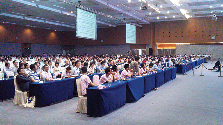
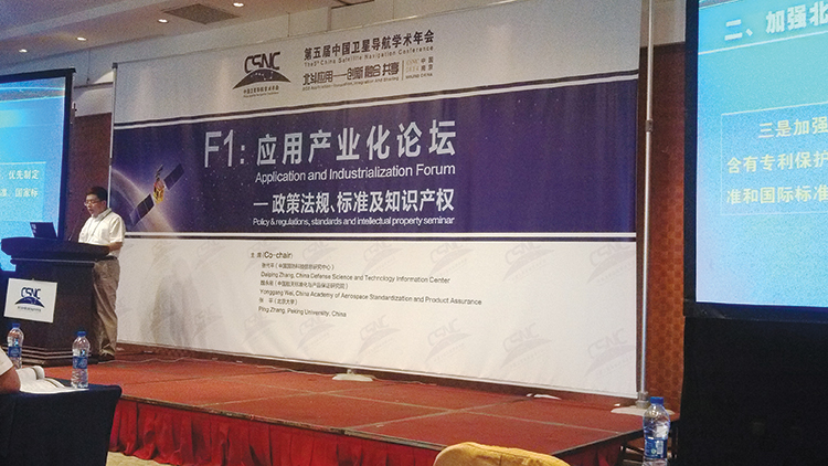 Conclusion