Tag: coronavirus

  • COVID-19 impact revealed through the lens of GPS

    COVID-19 impact revealed through the lens of GPS

    Movement, closeness, privacy — many things we took for granted a few months ago have become luxuries after the onset of COVID-19. To get an understanding of the scale and impact of the virus, we can look at global movement trends of people and merchandise using GNSS technology.

    Marine

    Before the coronavirus pandemic, globalization seemed to be increasing endlessly. Now, we face new trade restrictions, protectionist policies, and a global economic downturn that threatens to stunt growth for years to come.

    In April, the World Trade Organization (WTO) forecast that global trade would fall by between 13% and 32% in 2020, surpassing the “great trade collapse” of 2009 spurred by the global financial crisis.

    World merchandise trade volume, 2000-2022. (Source: World Trade Organization)

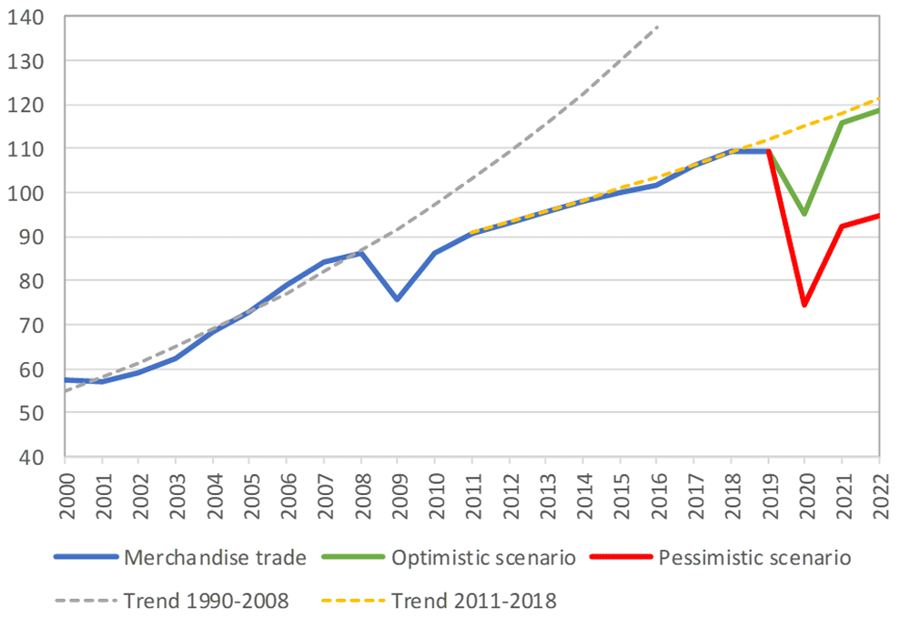
    However, the situation isn’t completely bleak. According to a recent Tradeshift report, global trade decreased by 14.8% in the second quarter of 2020, putting us on the optimistic end of the WTO estimate. June saw a rise in trade activity, suggesting that we may be recovering from the initial effects of the pandemic.

    Cargo vessels, tankers, tugs, and other kinds of commercial ships are equipped with satellite navigation devices that can receive information from GNSS satellites to compute precise location and time. Maritime tracking insights obtained via GNSS/GPS signals are a great method for measuring the impact of the coronavirus on trade.

    Photo: shaunl/E+/Getty Images
    Photo: shaunl/E+/Getty Images

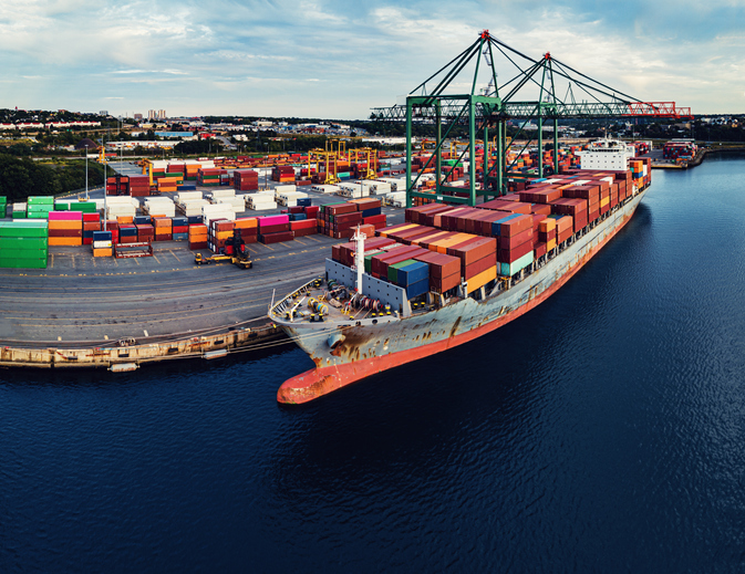
    GPS data from MarineTraffic shows that ship arrivals decreased in nearly all of China’s ports from January to March.

    Source: MarineTraffic
    Source: MarineTraffic

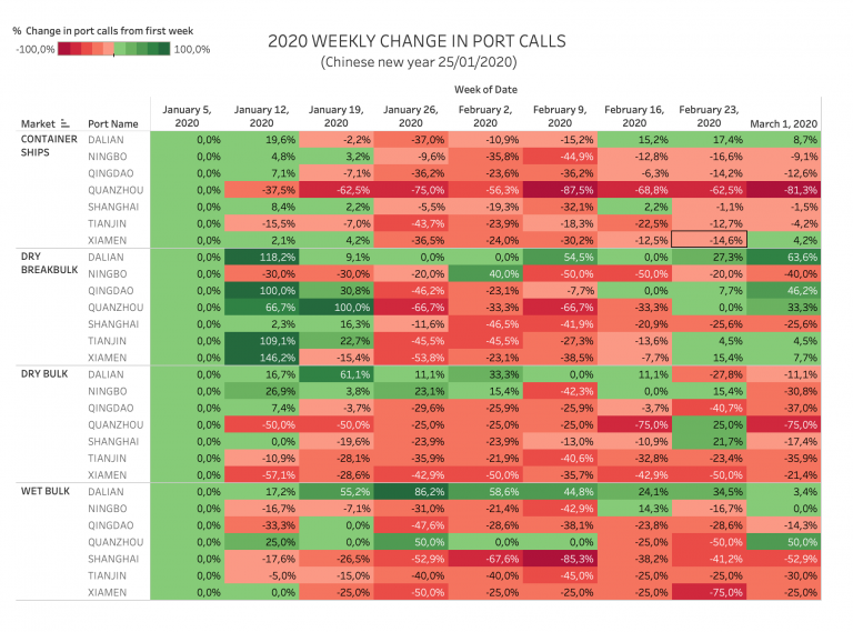
    Just as trade shipping began to pick up in China, the United States and Europe were hit hard by the pandemic. However, shipments have now begun to climb worldwide to compensate for cancellations earlier this year.

    The cruise industry, on the other hand, shows little indication of recovery. Cruises were the fastest growing segment of the travel industry over the past five years — until the pandemic hit.

    On June 19, the Cruise Line International Association (CLIA) and Centers for Disease Control and Prevention (CDC) announced a “no sail order” for cruise ships. The order has been extended through Sept. 30. Furthermore, the cruise industry’s reputation has been damaged by multiple outbreaks on ships, most recently the MS Roald Amundsen of Norway. At least 43 people were infected on the MS Roald Amundsen, and Norway has now banned cruise ships with more than 100 passengers from disembarking at Norwegian ports.

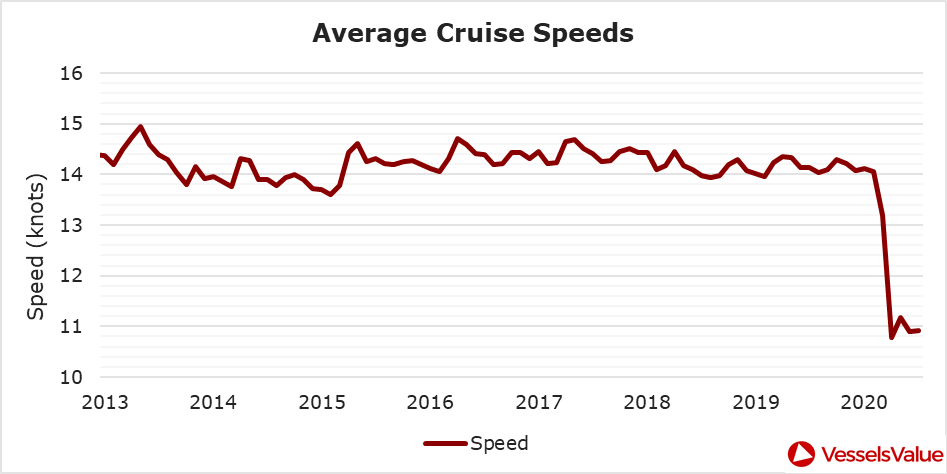
    Maritime intelligence company VesselsValue is using AIS data to map cruise ship activity throughout the pandemic. They have noted that while cruise ships typically sail at 13.5 knots to 15 knots, average speed has dropped to 11 knots in 2020 as ships attempt to lower fuel costs. Port-to-port sailings have declined for the 10 most popular cruise routes.

    Source: VesselsValue
    Source: VesselsValue
    Source: VesselsValue
    Source: VesselsValue

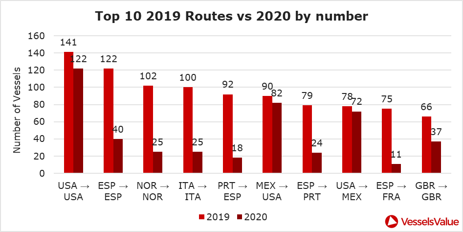
    Most of the port-to-port sailings that constitute the 2020 columns in the above graph actually represent ships being repositioned for a break in service, also called a “layup.” Layups can cost cruise companies millions of dollars per month, but with no sail orders and port closures, they are a necessary expense.

    According to the Oxford COVID-19 Government Response Tracker, a real-time monitoring system that evaluates government policies, April marked the strictest lockdown measures across all 133 available coastal countries. The tracker uses a stringency index between 0 and 100 based on national containment and closure policies.

    Source: Oxford COVID-19 Government Response Tracker
    Source: Oxford COVID-19 Government Response Tracker

    Air

    Commercial air traffic has decreased as well. According to GPS flight tracking service Flightradar24, the number of global daily flights was slashed by nearly two thirds between March and April. While there were 15,012 flights in the air at 15:00 UTC on March 7, there were only 5,275 at the same time on April 7.

    Global air traffic March 7, 2020. (Source: Flightradar24)
    Global air traffic March 7, 2020. (Source: Flightradar24)
    Global air traffic April 7, 2020. (Source: Flightradar24)
    Global air traffic April 7, 2020. (Source: Flightradar24)

    There were 55% fewer flights in the last week of March 2020 than in the last week of March 2019. While all types of air traffic have been reduced for fears of infection, the coronavirus has especially decimated demand for passenger flights. Passenger airlines across the world have canceled flights and cut capacity for the foreseeable future. Some passenger airlines have even switched to transporting cargo in a desperate attempt to avoid bankruptcy.

    Looking at regional tracking data can further illuminate the impact of COVID-19 on air travel. Travel restrictions and border closures were enacted en masse in late March, though some nations adopted more stringent policies than others.
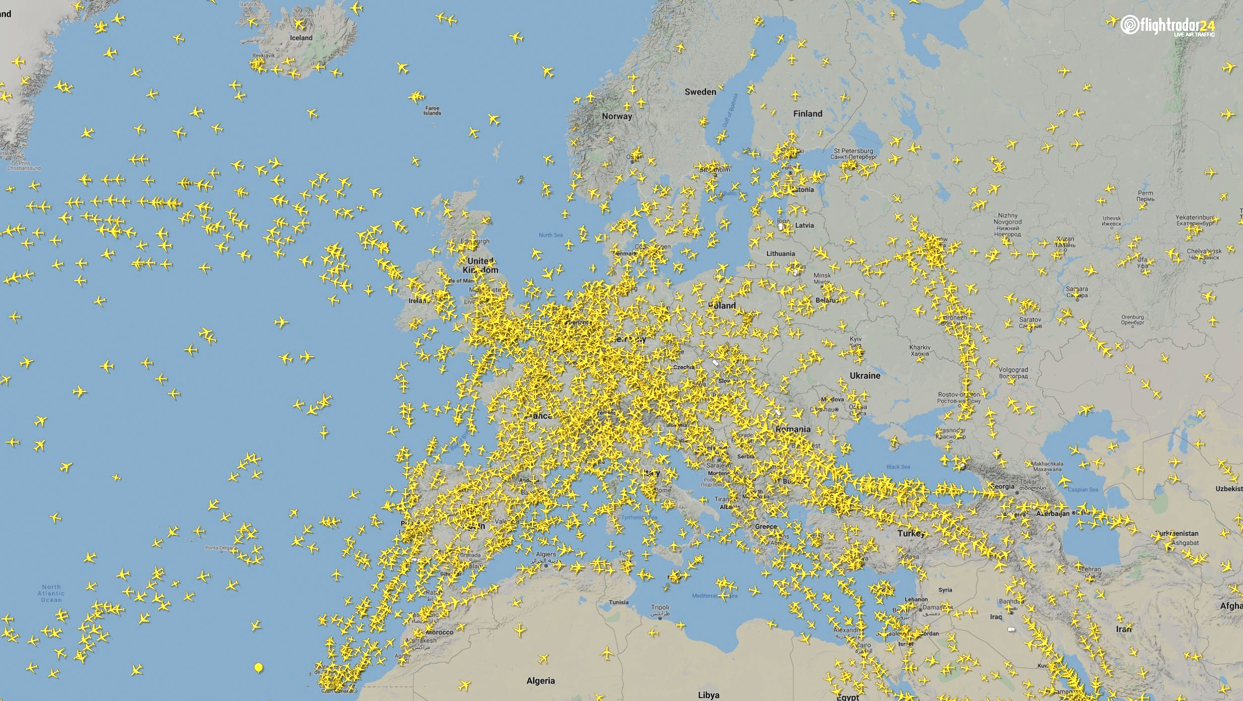
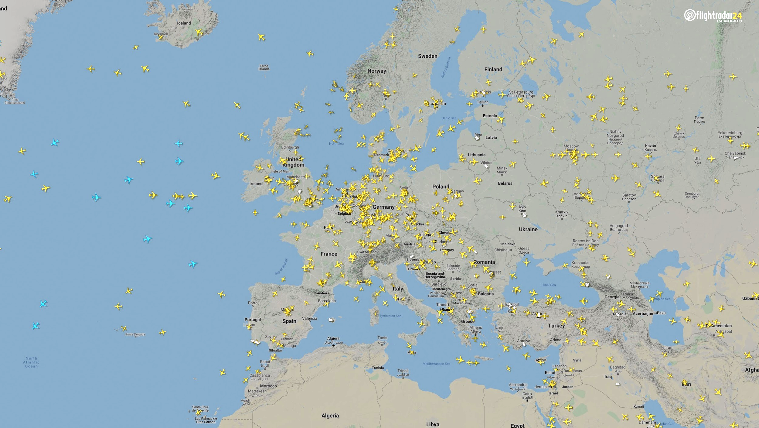
    Europe

    The number of flights in Europe has plummeted since the onset of the coronavirus pandemic. There were 2,400 fewer flights in Europe on April 7 than March 7.
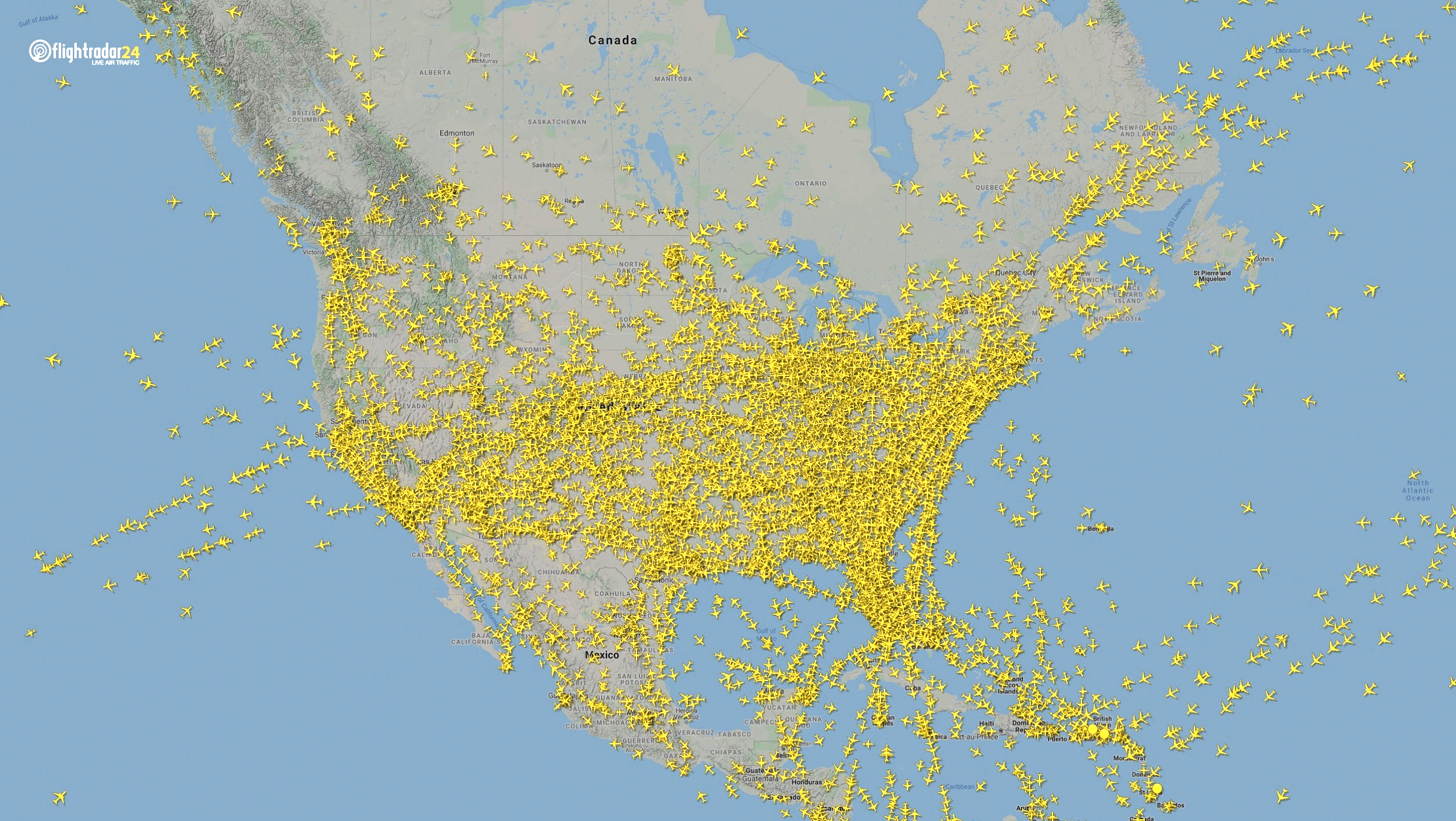
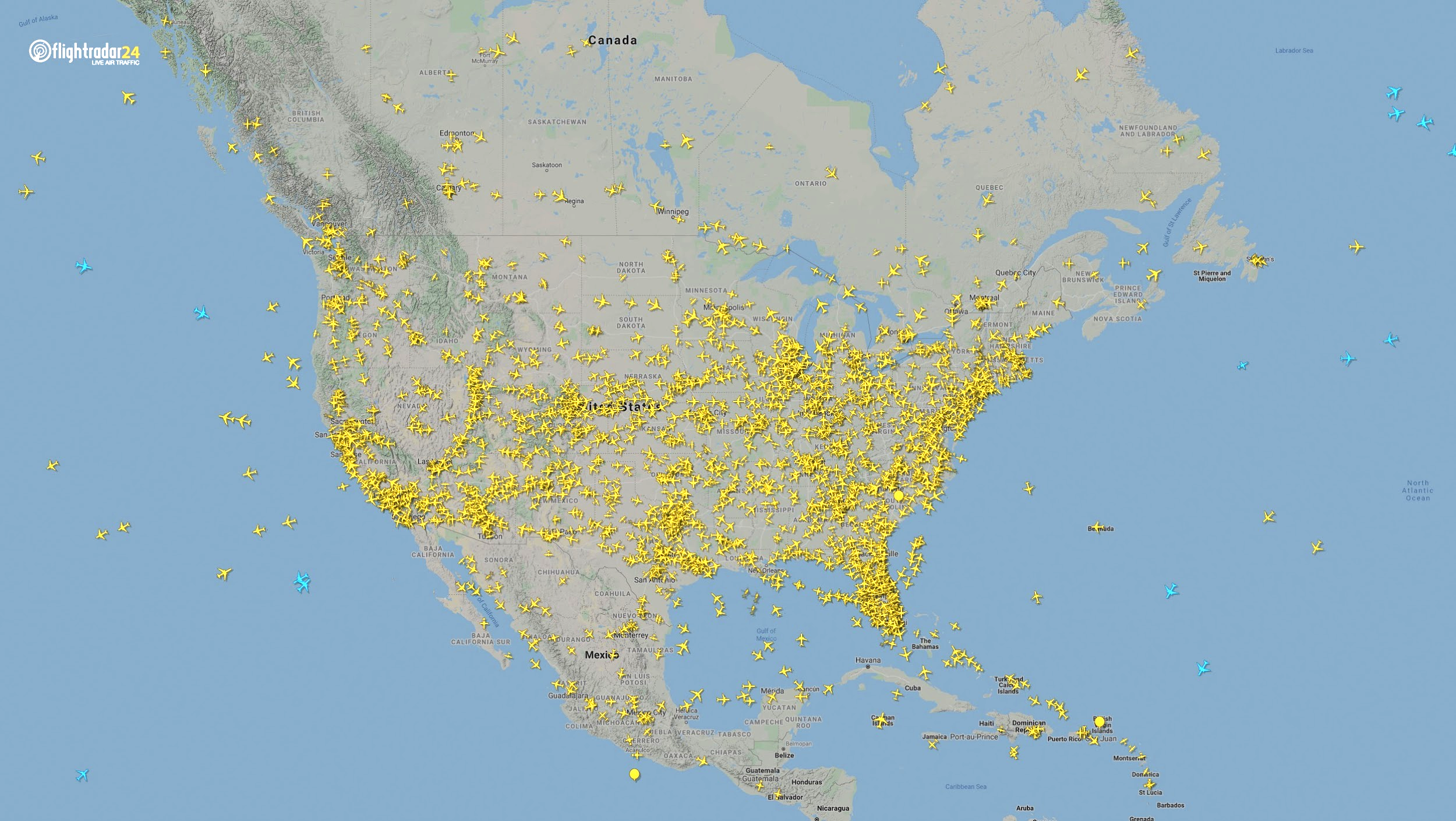
    Air traffic over Europe March 7, 2020. (Source: Flightradar24)
    Air traffic over Europe March 7, 2020. (Source: Flightradar24)
    Air traffic over Europe April 7, 2020. (Source: Flightradar24)
    Air traffic over Europe April 7, 2020. (Source: Flightradar24)

    North America

    Though air travel has been disrupted across North America, the United States remains significantly more busy than its neighbors. The March 7 image shows 8,400 flights while the April 7 image shows 2,950 flights, most of them concentrated over the United States.
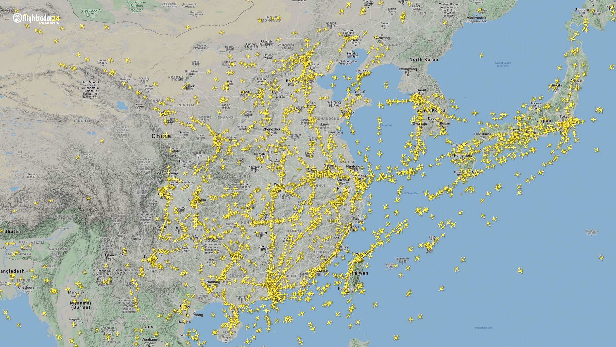
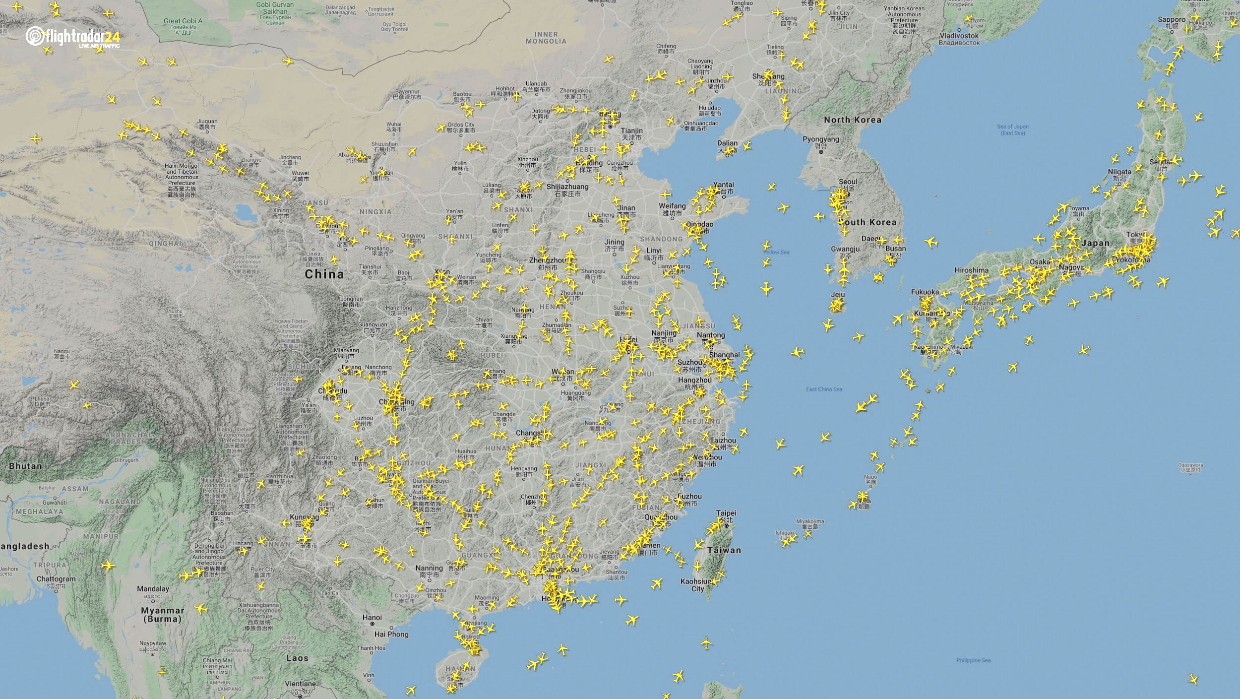
    Air traffic over North America March 7, 2020. (Source: Flightradar24)
    Air traffic over North America March 7, 2020. (Source: Flightradar24)
    Air traffic over North America April 7, 2020. (Source: Flightradar24)
    Air traffic over North America April 7, 2020. (Source: Flightradar24)

    East Asia

    The decrease in air traffic over East Asia has been severe and persistent. Since China and its neighbors began to experience a trade downturn as early as the third week of January, we can compare January 7 to April 7 to capture the effects of the coronavirus. As of late July, air traffic at China’s busiest airports was still down approximately 60% from normal levels.

    Air traffic over East Asia January 7. (Source: Flightradar24)
    Air traffic over East Asia January 7. (Source: Flightradar24)
    Air traffic over East Asia April 7. (Source: Flightradar24)
    Air traffic over East Asia April 7. (Source: Flightradar24)

    Ground

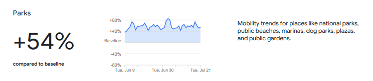
    Google has released — and continues to update — a series of community mobility reports that chart movement trends in public spaces. The reports are a compilation of GPS data for Google users across the world.

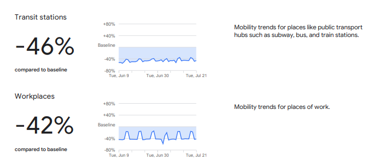
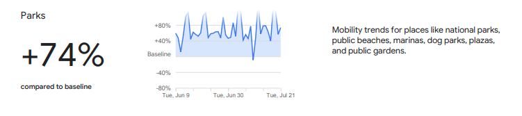
    Mobility changes are particularly stark for regions hit hard by the coronavirus. New York state showed a 46% reduction in visits to transit stations and a 42% reduction in visits to workplaces in June and July compared to pre-pandemic baseline levels. New Yorkers are also visiting parks 74% more often.

    Screenshot: Google
    Screenshot: Google
    Screenshot: Google
    Screenshot: Google

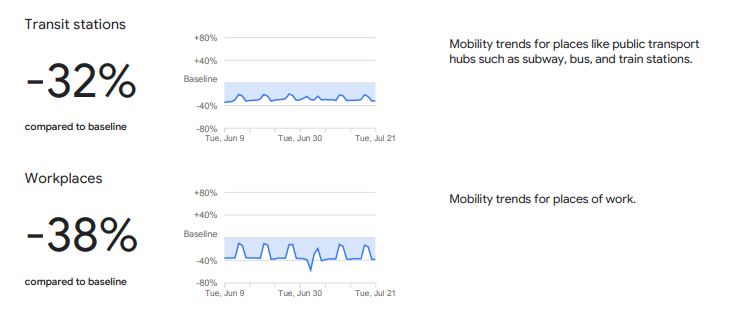
    Trends in the United States as a whole are also dramatic.

    Screenshot: Google
    Screenshot: Google
    Screenshot: Google
    Screenshot: Google

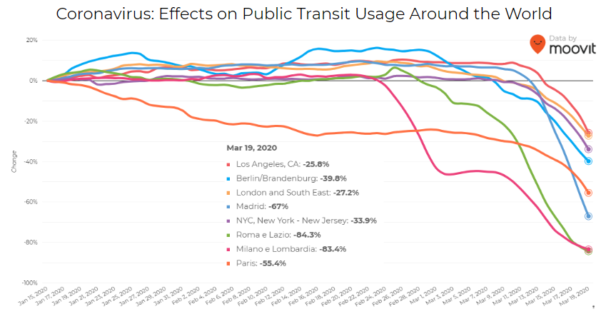
    Israeli journey-planning app Moovit is using mobile phone data to document trends in public transit ridership. Many of the world’s largest metropolitan cities experienced a steep decline in ridership between mid-January and late March. Millions of people that rely on mass transit have had to cope with cumbersome rules and the danger of catching the virus itself. Efforts to reduce overcrowding on trains and buses have translated into reduced capacity requirements and therefore, lengthy wait times. The rise of remote work has also lowered public transit ridership.

    Screenshot: Moovit
    Screenshot: Moovit

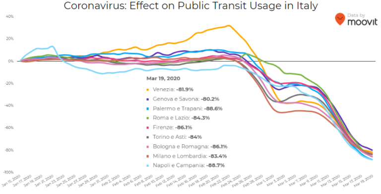
    Italy was hit particularly hard – and early – by the pandemic. Two large outbreaks occurred in Northern Italy in late February, prompting widespread closures and government-mandated quarantines in Lombardy and 14 neighboring provinces. Public transit ridership plummeted when the quarantine took effect in early March.

    Screenshot: Moovit
    Screenshot: Moovit

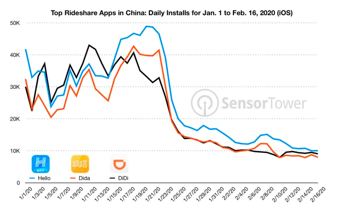
    Usage of GPS-reliant ride-hailing apps has also dropped severely. Daily installs of China’s three biggest ride-hailing apps were down 75% the week of February 10 compared to the same week in 2019.

    Source: Sensor Tower
    Source: Sensor Tower

    American ride-hailing giants Uber and Lyft have seen similar losses. However, business for food delivery apps like Uber Eats and Grubhub are on the rise as more people stay home instead of grocery shopping.

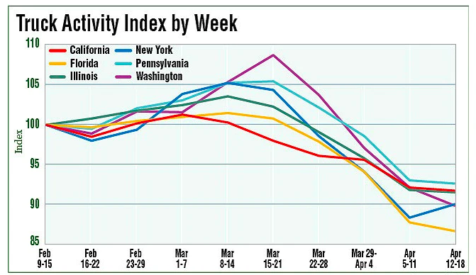
    The impacts of COVID-19 have been less severe — but still significant — for the trucking industry. The U.S. trucking industry is an economic powerhouse, typically generating over 700 billion in annual revenue and transporting 72.5% of American freight. The American Transportation Research Institute generated a truck activity index based on GPS data across six states from the week of February 9 to the week of February 12. The data shows an initial spike in trucking operations due to increased demand for consumer goods and medical supplies. However, as stay-at-home orders and restrictions ceased business operations across the country, truck activity declined.

    Source: American Transportation Research Institute
    Source: American Transportation Research Institute

    Coronavirus safety restrictions adopted by countries across the world have generally begun to loosen up, for better or for worse. It will be interesting to see how the coming months unfold through the lens of GNSS data.


    Roi Mitt works for Regulus Cyber, a company researching GPS cybersecurity and offering various software products to protect the integrity, reliability and security of GNSS devices. The company’s products are designed for multiple industries using GPS-based time and location, in order to ensure a future in which GNSS technology is safe and reliable to use.

    Sources

    https://www.mhlnews.com/global-supply-chain/article/21136753/global-trade-activity-falls-in-q2-but-moving-up

    https://www.businesswire.com/news/home/20200715005157/en/Global-Trade-Activity-Falls-14.8-Q2-Tradeshift

    https://www.wto.org/english/news_e/pres20_e/pr855_e.htm

    https://www.theguardian.com/science/2020/jun/25/spacewatch-china-launches-final-beidou-satellite-rival-gps-navigation-system

    https://thediplomat.com/2020/06/chinas-answer-to-gps-is-now-fully-complete/

    https://www.reuters.com/article/us-space-exploration-china-satellite/china-puts-final-satellite-into-orbit-to-try-to-rival-gps-network-idUSKBN23U08P

    Then and now: visualizing COVID-19’s impact on air traffic

    https://www.gstatic.com/covid19/mobility/2020-07-21_US_Mobility_Report_en.pdf

    https://www.gstatic.com/covid19/mobility/2020-07-21_US_New_York_Mobility_Report_en.pdf

    https://www.ttnews.com/articles/trucking-industry-revenue-topped-700-billion-2017-ata-report-shows

    https://www.trucking.org/news-insights

    https://www.refrigeratedtransporter.com/covid-19-coverage/article/21129910/atri-new-data-show-covid19-impacts-on-trucking

    This Week in Apps: Coronavirus impacts app stores, Facebook sues mobile SDK maker, Apple kicks out a cloud gaming app

    https://www.researchgate.net/figure/Figures_fig1_343271722

    https://www.nytimes.com/aponline/2020/08/04/world/europe/ap-eu-virus-outbreak-norway-cruise-ship.html

    https://www.cdc.gov/media/releases/2020/s0716-cruise-ship-no-sail-order.html

    The Cruise industry’s COVID-19 crisis: how bad is it really?

  • Global trends in the mapping industry during the pandemic

    Photo: SimActive
    Photo: SimActive

    By Philippe Simard, Ph.D.
    President, SimActive Inc.

    The COVID-19 pandemic has brought uncertainties to all businesses, and the mapping industry has been no exception.

    Slowdowns were observed during the first few months of 2020 as lockdowns were gradually enforced in Asia, then Europe, and finally the Americas.

    As expected, projects were delayed during that initial period as companies were reorganizing their operations to allow for remote work.

    Once that transition was overcome, a great number of projects resumed, and the geospatial field has been gradually coming back to normal since then. That can be explained by different factors, including, for example, several governments accelerating infrastructure projects to stimulate the economy.

    A lot of mapping firms have turned the pandemic into an opportunity to improve their processes. Slower times allow reviewing production workflows and assessing bottlenecks. Once identified, new hardware and software solutions can be evaluated to optimize production.

    Interestingly, the resulting investments into new solutions has been significant. Companies are seeing a quick payoff as their workload is rapidly accelerating, leading to an increase in their bottom line.

    Overall, the mapping industry was able to rapidly adjust to the new reality caused by the pandemic. The changes that are being made in performing projects not only allow us to minimize risks in the short term, but also to increase profitability in the longer term.


    SimActive is the developer of Correlator3D software, a patented end-to-end photogrammetry solution for the generation of high-quality geospatial data from satellite and aerial imagery, including drones. Correlator3D performs aerial triangulation (AT) and produces dense digital surface models (DSM), digital terrain models (DTM), point clouds, orthomosaics, 3D models and vectorized 3D features.

    Powered by GPU technology and multi-core CPUs, Correlator3D ensures high processing speed to support rapid production of large datasets.

    SimActive has been selling Correlator3D to leading mapping firms and government organizations around the world, offering cutting-edge photogrammetry software backed by exceptional customer support.

  • An overview of GPS/GNSS shows canceled or postponed because of COVID-19

    GPS/GNSS-related trade shows and conferences have been canceled or postponed because of the coronavirus pandemic. Below is an overview of these shows so far, starting with the most recent updates.


    AUVSI Xponential 2020: Virtual

    AUVSI Xponential 2020 logo

    The Association for Unmanned Vehicle Systems International (AUVSI) decided to convert AUVSI Xponential 2020 to a virtual event. It will still take place Oct. 5-8.

    Xponential 2020 was originally scheduled to take place May 4-7 at the Boston Convention and Exhibition Center. It was then rescheduled to take place Oct. 5-8 at the Kay Bailey Hutchison Convention Center in Dallas.

    “While we are disappointed to not be convening in person this year, the health and safety of Xponential exhibitors and attendees is our utmost priority,” Wynne said. “It may not look like the Xponential we are used to, but we look forward to offering attendees the opportunity to virtually network, learn from and collaborate with one another just as they have in years past.”


    Logo: ION JNC

    ION 2020 Joint Navigation Conference: Canceled

    The Institute of Navigation (ION) canceled its 2020 Joint Navigation Conference, which was scheduled to take place Sept. 8-11 in Covington, Kentucky/Cincinnati, Ohio.

    According to show organizers, the decision was made because of COVID-19 and the current U.S. Department of Defense and government travel restrictions that are limiting travel.

    ION JNC 2021 will be held June 7-10 at the Northern Kentucky Convention Center in Covington, Kentucky/Cincinnati, Ohio, with the classified session hosted at the Air Force Institute of Technology.


    Logo: ITSF Online

    ITSF 2020: Virtual

    The International Timing and Sync Forum (ITSF) is a time and synchronization conference and exhibition showcasing solutions for 4G/5G, finance, broadcast, automotive, smart grids, IoT, distributed datacenters, transport and defense. The 2020 event will be held virtually Nov. 3-5.

    “In the light of the current global situation, we are please to announce that ITSF 2020 will now be a fully virtual event — #ITSFOnline,” show organizers said.


    TU-Automotive: Virtual

    TU-Automotive will be held Aug. 18-20 in a virtual format.

    “After continuously reviewing the best ways to serve the Automotive community, we are thrilled to announce the launch of the Virtual edition of TU-Automotive Detroit, ADAS & Autonomous Vehicles, WardsAuto Interiors Conference and WardsAuto UX Conference,” show organizers said.

    The virtual event will feature keynotes, conference tracks, workshops, roundtables and working groups.


    Logo: Commercial UAV Expo Americas

    Commercial UAV Expos (America and Europe): Virtual

    Commercial UAV Expo Americas 2020 is going virtual, according to event organizer Diversified Communications. The event is slated to take place Sept. 15-17.

    “Due to ongoing health and safety concerns stemming from the COVID-19 pandemic, members of the commercial drone community we serve have made it clear that it would be impossible to hold the live event as originally planned. In the interests of ensuring our community still has an opportunity learn from and connect with each other, we have reimagined Commercial UAV Expo Americas as a fully virtual event taking place September 15-17, 2020,” said Lisa Murray, group director at Diversified Communications, organizer of Commercial UAV Expo Americas.

    Commercial UAV Expo Europe also will take place as a virtual event Dec. 1-3.

    “Due to ongoing concerns caused by the COVID-19 pandemic, and for the health and safety of the members of the commercial drone community we serve, we have made the decision to reimagine Commercial UAV Expo Europe as a fully virtual event this year which will take place as part of a hybrid live-virtual Amsterdam Drone Week 1-3 December, 2020,” Murray added.


    Logo: Intergeo 2020

    Intergeo 2020: Virtual

    Intergeo 2020, originally slated to take place Oct. 13-15 in Berlin, Germany, will now take place entirely virtually. Organizers announced in early June that the show would take place partially in person and partially virtually, but made the decision in early July to move the entire show to a digital platform.


    Logo: GEO Business

    GEO Business 2020: Postponed

    The venue and date have both been changed for GEO Business 2020. The show, organized by Diversified Communications U.K., will now take place May 19-20, 2021 at ExCel London. This event aims to connect those involved in the gathering, storing, processing and delivery of geospatial information.

    Read more about the conference here.


    5th annual FAA UAS Symposium: Virtual conference

    Logo: FAA UAS SymposiumThe Federal Aviation Administration (FAA) and the Association for Unmanned Vehicle Systems International (AUVSI) will host the 5th annual FAA UAS Symposium virtually, rather than in-person in Baltimore. The event will take place June 16-18.

    The FAA and AUVSI also will be hosting a series of virtual events that will address the content already planned for this year’s program. The fist will take place in early summer and will focus on UTM and international UAS integration. The second will take place in late summer with a focus on updates to the Integration Pilot Program and public safety operations.

    Learn more about the show here.


    AUVSI Xponential: Postponed

    AUVSI Xponential 2020 logoThe AUVSI Xponential trade show, originally scheduled to take place May 4-7 in Boston, has been rescheduled to take place Oct. 5-8 in Dallas.

    Because of the rescheduled conference, AUVSI will be hosting Xponential Virtual Sessions, a week-long webinar series, May 4-8. Find out how you can participate here.

    Read more about the conference here.


    Logo: Trimble Dimensions 2020

    Trimble Dimensions 2020: Canceled

    Trimble Dimensions 2020, which was scheduled to take place Nov. 2-4 at the Gaylord Opryland Resort and Convention Center in Nashville, Tennessee, has been canceled.

    “Unfortunately, the overwhelming concerns and ongoing impact of COVID-19 inhibit our ability to deliver a conference that meets the high standards of safety and excellence our attendees expect and deserve,” Trimble said in a press release.

    Read more about the show here.


    Logo: IAC 2020

    International Astronautical Congress 2020: Virtual conference

    The 71st International Astronautical Congress (IAC): The CyberSpace Edition will take place virtually Oct. 12-14. The show, originally scheduled to take place in Dubai, brings together stakeholders from space agencies and institutions around the world to exchange information and ideas, share developments and advancements, and swap insights and rising trends.

    According to show organizers, the IAC is a one-of-a-kind assemblage, unmatched in scale and in scope, unequalled in its reach and its attendance.

    Read more about the virtual conference here.


    Esri User Conference: Virtual conference

    Logo: Esri

    The Esri User Conference, which typically takes place every July in San Diego, will be held virtually July 13-15. The plenary session, technical workshops and Esri Showcase will be virtual, featuring demonstrations and live discussions during the conference.

    Read more about the virtual conference here.


    AIxSPACE: Postponed

    AIxSPACE will now be taking place Nov. 2 in Montreal, Québec, Canada. According to show organizers, AIxSPACE brings together stakeholders in space and artificial intelligence industries to allow everyone to obtain concrete information on these markets and connect with potential business partners.

    Read more about the conference here.


    ENC logo

    European Navigation Conference: Postponed

    The European Navigation Conference has been rescheduled to take place Nov. 22-25 at the Maritim Hotel & Internationales Congress Center in Dresden, Germany. The conference, hosted by the German Society for Positioning and Navigation, brings together scientists, engineers and international experts to discuss new ideas, latest research results, future developments and new applications.

    Read more about the conference here.


    Connected & Autonomous Vehicles Conference: Postponed

    The Connected & Autonomous Vehicles Conference has been postponed and will now be taking place Aug. 10-13 at the San Jose Convention Center in California. The conference aims to highlight the latest automotive industry developments, as well as allow participants to engage with experts and form strategic alliances.

    Read more about the conference here.


    Logo: ION

    ION Joint Navigation Conference: Postponed

    The Institute of Navigation’s (ION) Joint Navigation Conference (JNC) has been rescheduled for Sept. 8-11 at the Northern Kentucky Convention Center. JNC is a U.S. military positioning, navigation and timing conference with joint service and government participation. According to ION, the rescheduled conference will host the original program, which was scheduled to take place in June.

    Read more about the conference here.


    36th Space Symposium: Postponed

    The 36th Space Symposium will now take place Oct. 31 to Nov. 2 at The Broadmoor in Colorado Springs. According to the Space Foundation, the 36th Space Symposium will gather leaders, innovators and entrepreneurs from the civil, commercial, military, research and international sectors to share, explore and partner on efforts that will impact our lives beyond Earth and upon it.

    Read more about the conference here.


    IEEE/ION PLANS Conference: Canceled

    The IEEE/ION PLANS Conference, originally scheduled to take place April 20-23 in Portland, Oregon, was canceled.

    Read more about the cancellation here.


    Munich Satellite Navigation Summit: Canceled

    Logo: Munich Satellite Navigation Summit

    The Munich Satellite Navigation Summit, originally scheduled to take place March 16-18, was canceled.

    “In light of the current situation caused by the coronavirus as well as related travel restrictions and resulting cancellations we unfortunately are forced to cancel the Munich Satellite Navigation Summit 2020 as we are no longer able to provide a well-ordered and appropriate program,” show organizers said in a press release.

    Read more about the cancellation here.


    Logo: Mobile World Congress 2020

    Mobile World Congress: Canceled

    Mobile World Congress, which was slated to take place Feb. 24-27 in Barcelona, Spain, was canceled.

    “With due regard to the safe and healthy environment in Barcelona and the host country today, the GSMA has cancelled MWC Barcelona 2020 because the global concern regarding the coronavirus outbreak, travel concern and other circumstances, make it impossible for the GSMA to hold the event,” said GSMA CEO John Hoffman in a statement.

    Read more about the cancellation here.


    Read more of GPS World‘s coronavirus coverage here.


    Featured image: rclassenlayouts/iStock / Getty Images Plus/Getty Images

  • Using contact tracing and GPS to fight spread of COVID-19

    Using contact tracing and GPS to fight spread of COVID-19

    Tracing Location

    Contact tracing can help stem the spread of the COVID-19 pandemic. It involves tracking the movement and interactions of infected individuals to identify others at risk.

    National and regional responses to the COVID-19 pandemic have included containment through quarantine and restriction of movement. When properly implemented, these solutions limit spread of the contagion to prevent it from overwhelming healthcare and emergency management systems.

    According to the World Health Organization, the Centers for Disease Control and Prevention, and virtually all medical professionals, any effective strategy to return the world to normal requires three components: testing, contact tracing and isolation.

    While testing to find the people who are infected is the absolute top priority, contact tracing is vital for stopping a disease from spreading out of control. It involves tracking the movement and interactions of infected individuals to identify others at risk. Any positive test without contact tracing is bad public health — it misses an opportunity to reduce the spread of the virus.

    While the concept of contact tracing has just entered popular consciousness, it has been a standard public health tool for a century. For example, in the 1930s, Great Britain used it to contain the incidence of sexually transmitted infections. In the 1960s and 1970s, South American, African and Asian countries used it to eradicate smallpox. Additional diseases for which contact tracing is performed include tuberculosis, measles, HIV, Ebola, bloodborne infections, serious bacterial infections and novel infections.


    What Is Contact Tracing?

    The World Health Organization describes three basic steps:

    • Contact identification. Those who have been in contact with someone who has been confirmed to be infected are identified, by asking about their activities and those of the people around them.
    • Contact listing. All persons who have had contact with the infected person are informed of their status and told to receive early care if they develop symptoms.
    • Follow-up. Contacts are monitored for symptoms and tested for signs of infection.

    In some cases, quarantine or isolation is required for high-risk contacts.


    The enormous dimensions of the current pandemic, however, challenge traditional models of contact tracing, which are very resource intensive. In search of a technological assist, several Asian countries already have been taking advantage of the functionalities of smartphones to scale up contact tracing to match the pandemic’s rate of growth, such as the Trace Together app built by the Singapore government. Companies and organizations around the world are following suit, including Britain’s National Health Service, a pan-European initiative, and an unprecedented joint venture by Apple and Google.

    Automating Contact Tracing

    A study published on March 31 in Science concluded that “viral spread is too fast to be contained by manual contact tracing but could be controlled if this process [were] faster, more efficient and happened at scale.” A contact-tracing app that memorizes close contacts and immediately notifies users if they have had contact with infected individuals, prompting them to self-isolate, could control the pandemic without need for mass quarantines if enough people used it, the study argues.

    Privacy versus Protection. A similar app has been deployed in China, where people are required to use it to be allowed to move beyond their neighborhood, enter public spaces, or use public transport. A central database collects data on each user’s movement and coronavirus diagnosis, artificial intelligence analyzes these data, then the app displays a red, amber or green code that determines the user’s freedom of movement. This app has been credited with significantly helping China suppress the pandemic, but has been criticized for its disregard for data protection and privacy.

    Relying on fundamental epidemiological principles and common smartphone functionality, the Science study authors designed a simple algorithm to replace manual contact tracing. “Coronavirus diagnoses are communicated to the server, enabling recommendation of risk-stratified quarantine and physical distancing measures in those now known to be possible contacts, while preserving the anonymity of the infected individual.” Symptomatic individuals could use the app to request testing, and everyone could use it to access COVID-19-related health services, information and instructions, or even to request deliveries of food or medicine during self-isolation.

    Public trust in the app and how the gathered data are used would be critical to its success. The study’s authors lay out a series of requirements for its ethical implementation, then point out that “the algorithmic approach we propose avoids the need for coercive surveillance, since the system can have very large impacts and achieve sustained epidemic suppression, even with partial uptake.”

    The authors of a similar article in the journal JMIR mHealth and uHealth write that a contact-tracing system can limit any central coordination to notifying users who have been in contact with an infected person. Their core idea is that it does not matter where someone contacts an infected person, only that they were in close enough contact to risk infection. Particularly sensitive location data, such as GPS or phone cell data, “is actually neither necessary nor useful.” No one learns who the user is because the app is not linked to an identity, and it neither records nor stores location data.

    The authors argue their proposed app is the most effective epidemiologically because it would determine which people were in close proximity, and it would receive user cooperation. “Only if people trust a system — because it does not spy on them — will the system find broad support in the population.”

    GPS, Bluetooth or Both?

    Technologically, the concepts of location and proximity are embodied in two standard smartphone components: GPS receivers and Bluetooth transceivers. GPS-derived location data makes it possible to map and analyze the movements of individuals and of large numbers of people; for example, it is how we know that many in this country have begun relaxing social distancing rules ahead of the lifting of legal mandates. Bluetooth’s use of low energy, generally a drawback, becomes an advantage here because it can tell us whether two or more people have been within 1.5 to 2 meters of an infected person for at least 10 to 15 minutes — when the risk of infection is highest. This knowledge can enable newly infected, pre-symptomatic people to self-isolate and not infect others.

    Numerous companies are developing and proposing smartphone-based contact tracing apps.

    Vesedia Mobile Technologies proposes that people who test positive to COVID-19 be asked to provide information about public places they visited in the preceding days and at what times, using their phone location history for verification. The information would be anonymized by healthcare officials, and entered into a database that would be publicly accessible via a website and mobile app.

    Ramesh Raskar. (Photo: MIT/John Werner)
    Ramesh Raskar. (Photo: MIT/John Werner)

    Intersections. The COVID Safe Paths phone app and the Safe Places browser tool for contact tracers were created by Ramesh Raskar and other researchers at the MIT Media Lab. If a user tests positive and consents, his or her data is uploaded, redacted by healthcare authorities to remove any personally identifiable information, and downloaded by the app.

    The app then performs “intersections” — it identifies and notifies people with whom the infected person has crossed paths. By clicking on intersections, users can display their timeline for the past 14 days, in a calendar view, which tells them how many intersections have occurred each day.

    The app also provides news reports from authorized local news channels, based on each user’s position or if they tap the URL for their local healthcare authority, said Abhishek Singh, the program’s tech lead, who is helping with the app’s development.

    “We are also building an interoperable architecture,” Singh said. “Because there are many contact tracing apps already in the wild, we want to make sure that they have some common standards and guidelines that enable them to utilize data from other apps securely and through consent.” More than 1,200 people are voluntarily contributing to the project. “It is being led by the open-source community, and all our source code is out there and anybody can contribute,” Singh said.

    Safe Places is helping health authorities by making the data and insights visible, enabling them to make the right decisions such as targeting resources to areas that need them most, helping them impose restrictions such as lockdowns, or reopen the economy. “The economy will not reopen in a single burst, but step by step.” Singh said. “A dashboard that allows them to monitor where the infection is spreading and where it has been contained helps them decide where to take which steps.”

    The GPS Advantage. The uptake required for GPS-enabled contact tracing to be successful is generally lower than for Bluetooth-based contact tracing, Singh argues, citing an Oxford University simulation. “With GPS, you do not need people to have the app already downloaded for it to be effective,” he points out. A person who tests positive for the virus can use the Safe Place web tool to manually create a GPS trail and help healthy people. This is one of the biggest advantages of GPS compared to Bluetooth, because the latter requires exchanging information directly through the hardware, which cannot be done after the fact.

    Because the app is open source, any government can deploy it using its own IT infrastructure. However, a government that wants to adopt Safe Paths must sign a letter that commits it to complying with privacy and ethical guidelines. Preventing authoritarian governments and nosy employers from requiring people to use this app and reveal their data requires stringent guidelines as to how it is deployed and who can access the data, Singh said.

    Apple and Google Join Forces

    Apple and Google have joined in an unprecedented alliance to develop a system for notifying people who have been near others who have tested positive for COVID-19. Eight out of 10 people in the United States own smartphones, and the two companies’ operating systems run more than 99% of them. Apps built directly into iOS and Android, especially if interoperable, could dramatically increase the reach of public health authorities (the only organizations that would receive the data). To avoid fragmentation and encourage wider adoption, Apple and Google will allow only one app per country to use their system, but will allow U.S. states to use it and support countries that opt for a state or regional approach.

    The system will use Bluetooth signals from phones to detect encounters rather than GPS location data. It will not run ads, will require users to opt-in, be decentralized, and use randomized IDs not tied to a user’s actual identity to communicate potential contacts with individuals with a confirmed positive COVID-19 diagnosis.


    With GPS, you do not need people to have the app already downloaded for it to be effective.


    API Coming. On May 20, Apple and Google released an API to developers. Next, they will issue a system update to build in contact tracing at the OS level. Should a user’s phone notify them of a possible contact, they will be prompted to download and install a public health app from their local health authority to obtain trusted instructions.

    Developers of coronavirus-related apps for several U.S. states have argued that GPS location data is vital to identify infection hotspots and track outbreaks. However, for various technical reasons, workarounds designed to bypass the decision by Apple and Google and collect GPS data in connection with their contact tracing system would work poorly.

    Ethical and Equity Concerns

    “The work that we are doing for COVID-19 is pretty similar to work that we do on a routine basis with other reportable communicable diseases,” said Lisa Ferguson, nursing supervisor for Communicable Disease Investigations and Case Management for Multnomah County, Oregon, which includes the city of Portland. Most commonly, her unit is notified of illnesses by the state database, which receives electronic lab reports. “We assign that as a case to somebody on our team, and they call the person, interview them, ask some questions about their illness, their symptoms and where they could have possibly been exposed,” Ferguson explained. “Then, they talk about who that person might have exposed and where they were from two days before they became sick up until the time of the interview or the time that their symptoms were resolved.”

    The Multnomah County, Oregon, Disease Detection Team. (Photo: Multnomah County, Oregon)
    The Multnomah County, Oregon, Disease Detection Team. (Photo: Multnomah County, Oregon)

    How could technology — such as smartphone location data — best help Ferguson’s team conduct contact tracing for COVID-19? “In the public health world, we are not used to having access to technology in that way,” she said. “We need to have some ethical discussions before we are prepared to utilize something like a technology that can track people.” Also, unlike tracking measles, which requires knowing whether someone was in an airspace and who was there after them, “We do not automatically consider someone to have been exposed if they were in the same airspace as someone who tested positive.”

    If the privacy concerns could be adequately addressed, receiving a list of all the people who were less than six feet away for at least 10 minutes from someone who had tested positive could help her team scale up, Ferguson said. Her team would then reach out to those people, using such language as “You may have been exposed,” and “Please watch yourself closely.”

    Ferguson’s team always has “equity concerns,” fearing they might under-identify groups that do not have access to the technology. “It is a supplemental tool, but it certainly would not replace the work that we are doing,” she said.

    Help Wanted

    Safely reopening the United States will require a new workforce of at least 100,000 contact tracers, according to a report from the Johns Hopkins Center for Health Security and other experts. Any technological assist to contact tracing does not diminish this need. For example, smartphone alerts can help filter out those at low or no risk so that human tracers can focus on genuine cases, people at higher risk, or those who are harder to contact.

    Two out of 10 people in the United States do not own a smartphone, and only 42% of those above the age of 65 — who suffer 80% of the deaths from COVID-19 — do, according to a 2017 Pew Research Center poll. Hardly any homeless people own a smartphone. Among those most vulnerable to the pandemic are immigrants who do not speak English and are fearful of efforts to collect their personal information, strengthening the need for this to be done in person by trusted community members.

    Finally, even if Google and Apple’s automated service is widely adopted and works well, it will require many thousands of health workers to conduct tests and follow-ups.


    Feature photo: da-kuk / iStock / Getty Images Plus / Getty Images

  • Javad Ashjaee, founder of Javad GNSS, succumbs to coronavirus

    Javad Ashjaee, founder of Javad GNSS, succumbs to coronavirus

    Javad Ashjaee (Photo: Javad GNSS)
    Javad Ashjaee (Photo: Javad GNSS)

    Javad Ashjaee, founder of Javad GNSS, has died in Moscow, Russia. He died on May 30 after a three-week fight with COVID-19.

    The news was first reported by a family member on social media. Ashjaee was born in 1949.

    “It is with heavy hearts that we share the news of the passing of our founder Javad Ashjaee, a GPS/GNSS pioneer and visionary, on the morning of May 30, 2020, due to COVID-19 in Moscow, Russia,” reports a statement on the JAVAD GNSS website.

    The website continues, “Over the course of 37 years, Javad made an incredible and far-reaching impact in the GNSS community. He pioneered the world’s most advanced GNSS technology through a multi-national effort that combined GPS and GLONASS and established more than a quarter century of partnership between Silicon Valley and Moscow. He was always proud of this ‘success story of cooperation.’ Javad was a true industry disrupter long before the term and concept became popular. His whole way of doing business was challenging and disrupting to the status quo.”

    Read more about Ashjaee in his own words on the Javad GNSS website, where he describes the founding of his company:

    “In 1998 I founded Javad Positioning Systems (JPS) and introduced Legacy, Odyssey and Regency products, followed by HiPer. It was a 76-channel geodetic receiver. Other companies later copied HiPer. Today, many of GNSS receivers look like it. I sold JPS to Topcon, who changed its name to Topcon Positioning System and is a very successful company.

    “In 2007, after my obligations to Topcon ended and according to the provisions of our agreement, I founded Javad GNSS and introduced Triumph products. These were 216-channel receivers, integrated with several communication channels. We also introduced their Alpha, Delta, and Sigma versions. We were again the first to offer European Galileo and Japanese QZSS tracking in mass production. Triumph technology has been shown to have the best signal quality and best multipath reduction capabilities against all others tested by the German Aerospace. We also introduced GLONASS inter-channel (group/carrier delay) calibration to 0.2 millimeter which made GLONASS FDMA as good as GPS CDMA. Javad GNSS is growing fast and gaining market share.”


    Articles, insight provided by Ashjaee to GPS World

    June 2011, p. 60, “How GPS and GLONASS Got Together — and Other Recent Events
    December 2012, p. 30, “Dealing with Interference: A Proactive Approach for More Efficient Spectrum Use
    January 2018, p. 8, “What is the biggest challenge facing designers of multi-constellation GNSS receivers today?
    February 2019, p. 40, “The Key to Accuracy for High-Precision Applications


    More on Ashjaee throughout the years


    A word from Ashjaee’s nephew

    Ashjaee’s nephew Sol Adibnejad provided this biography on his uncle via social media:

    Javad was born in 1949 in Qom, Iran. After finishing his bachelor’s degree in electronic physics from the University of Teheran in Iran, he left Iran in 1972 to continue his education at the University of Iowa and got his graduate degrees, a doctorate in 1976. He went back to his native country Iran to teach at the university. He became the chairman of the Department of Computer Engineering at the Aryamehr University of Technology where he founded and managed a UNIVAC-100 computer centre. There, he created the first Iranian microprocessor lab. In 1978 he created one of the earliest student online and interactive registration systems in the world. In a few years and after the 1978 revolution and the political turmoil, things happened and he had to flee the country in 1981.

    He went straight back to the U.S. and started the next chapter of his journey in life which led to the pioneering of GPS. He spent the rest of his life designing and manufacturing of many generations of his GPS and JPS products at JAVAD GNSS, JAVAD ArWest and JAVAD EMS in the Silicon Valley. Javad Ashjaee is listed as the primary inventor in 102 granted patents, the last one in April 2020.

    Products: http://javad.com/jgnss/javad/news/pr20111228.html
    Inventions: https://patents.justia.com/inventor/javad-ashjaee
    Early life: http://archive.amerisurv.com/PDF/Professional_Surveyor_Magazine_Javad_Interview.pdf

    Below is his post on Facebook.

  • GPS World coverage of COVID-19

    GPS World coverage of COVID-19

    GPS World is offering the latest news and updates concerning the coronavirus (COVID-19) pandemic as it affects the GNSS/PNT industry. Read a message from GPS World here.

    Features

    COVID-19 impact revealed through the lens of GPS (12/1/20)
    GNSS helps fight coronavirus while companies adapt (11/3/20)
    COVER STORY: Indoor location could mitigate COVID-19 (6/25/20)
    Skyports joins Thales in COVID-19 drone-delivery trial (6/25/20)
    Taking to the field during the coronavirus pandemic (6/25/20)
    TopXGun Robotics uses drones to fight COVID-19 from above (6/25/20)
    Using location data in the fight against COVID-19 (6/25/20)
    Survey Scene Insights: Surveying and COVID-19: A lesson in essential services (5/6/20)
    COVER STORY: GNSS industry adapts during COVID-19 pandemic (4/13/20)
    Seen & Heard: Drones and robots fight coronavirus (3/5/20)
    Coronavirus, organ transport top medical drone uses (2/19/20)

    NEWS

    GNSS-RO measurements improved with COVID-19 pandemic (9/24/20)
    Drone payloads to become vital in supplying medicines, test results in COVID-19 pandemic (7/30/20)
    GMV leads development of ESA COVID-19 Space Hunting Platform (7/20/20)
    Garmin offers insights on active lifestyles during COVID-19 (5/1/20)
    How is COVID-19 affecting you? Take part in our survey (4/22/20)
    US small business loans a challenge due to COVID-19 (4/20/20)
    Plans to reopen after COVID-19 vary widely (4/20/20)
    Airbus to produce 3D-printed visors in fight against COVID-19 (4/17/20)
    Galileo Masters 2020 open for submissions (4/16/20)
    Martek Marine launches COVID-19 tests for crew changes (4/15/20)
    Robotic Research innovates to help fight COVID-19 (4/15/20)
    New Topcon Talks aimed at professionals at home during COVID-19 (4/9/20)
    Coronavirus delays GPS III SV03 launch until June (4/8/20)
    Schriever stays operational despite COVID-19 (4/3/20)
    PCTEL terminates share repurchase program (4/2/20)
    U.S. Space Force accepts control of GPS III SV02 amidst global pandemic (4/1/20)
    Testing suspended on Galileo Batch 3 satellites (3/30/20)
    GPS tracking shows critical truck deliveries continue despite COVID-19 (3/26/20)
    China adds to BeiDou as satnav service helps fight coronavirus (3/10/20)

    Mapping & geospatial

    GIS tool provides updates on open businesses amid COVID-19 (4/22/20)
    NSGIC issues joint statement on value of GIS during COVID-19 pandemic (4/17/20)
    How to prepare and organize a fleet during the COVID-19 pandemic (4/13/20)
    Dashboard graphs those working from home during COVID-19 (4/10/20)
    Georgia county provides grocery store app for residents (4/8/20)
    Esri releases resources for businesses during COVID-19 (4/3/20)
    Esri to provide mapping resources to WHO Member States (4/1/20)
    Analysis of satellite imagery shows reduced NO2 in China, Italy (3/23/20)
    Esri supports John Hopkins COVID-19 Design Challenge (3/27/20)
    Genasys releases COVID-19 interactive map layer service (3/19/20)
    Esri ArcGIS map tracks global coronavirus cases (3/13/20)

    Mobile apps & location intelligence

    Esri offers COVID-19 resources for nonprofits (5/8/20)
    Galileo positioning aids with COVID-19 tracking apps (4/29/20)
    Vesedia proposes COVID-19 contact tracing platform (4/27/20)
    Traxens offers smart-container tracking to manage COVID-19 supplies (4/21/20)
    Radius Telematics sees spike in vehicle theft during coronavirus crisis (4/15/20)
    GPS tracking need not sit out COVID-19 because of privacy laws (4/8/20)
    Esri to provide US school data during COVID-19 pandemic (4/8/20)
    InnerSpace location platform supports public safety, COVID-19 response (4/1/20)
    Sewio helps fight COVID-19 with ‘smart quarantining’ (4/1/20)
    European GNSS Agency provides list of COVID-19 apps (3/30/20)
    19 countries track mobile location to fight COVID-19 (3/26/20)
    Coronavirus and location: Is there a line? (3/23/20)
    WHO Health Alert brings COVID-19 facts to billions via WhatsApp (3/21/20)
    COVID-19: Israel’s citizens now tracked by their smartphones (3/19/20)
    Oxford University explores feasibility of coronavirus tracing mobile app (3/18/20)

    UAVs

    How drones are helping with COVID-19, first response applications (10/21/20)
    Drone payloads to become vital in supplying medicines, test results in COVID-19 pandemic (7/30/20)
    Benefits of commercial drones and upcoming major trends (7/30/20)
    Long-endurance drones prove their value against COVID-19 (5/6/20)
    Parrot helps design MakAir respirators for COVID-19 support (4/28/20)
    NCDOT initiative use drones for COVID-19 relief efforts (4/24/20)
    Draganfly conducts pandemic drone tests in US (4/21/20)
    AUVSI report: Demand growing for expanded drone operations (4/21/20)
    UAVOS completes tests for drone delivery of humanitarian relief (4/17/20)
    Kazakhstan uses drones to patrol capital during COVID-19 lockdown (4/9/20)
    Drone Delivery Canada asks for COVID-19 use cases (3/30/20)
    DJI joins with firefighting provider Rosenbauer on digital emergency response (3/30/20)
    ARPAS-UK coordinates COVID-19 drone capability task force (3/30/20)
    Pandemic drones to monitor, detect those with COVID-19 (3/26/20)
    China fights coronavirus with delivery drones (3/6/20)
    Xag creates fund for drones disinfection program to fight coronavirus (2/11/20)

    Show Updates

    Postponed 2021 IGS Workshop now to take place in 2022 (1/5/21)
    ION changes date for 2021 Joint Navigation Conference (12/17/20)
    GEO Business 2021 moved to the fall (12/17/20)
    NAVCEN hosts 60th CGSIC meeting virtually before ION GNSS+ 2020 (8/13/20)
    AUVSI Xponential 2020 goes virtual (7/24/20)
    ION cancels 2020 Joint Navigation Conference (7/20/20)
    Intergeo 2020 to take place virtually only (7/8/20)
    5th annual FAA UAS Symposium goes virtual because of COVID-19 (5/13/20)
    AUVSI Xponential postponed until October because of COVID-19 (5/5/20)
    Trimble Dimensions 2020 canceled because of COVID-19 (5/1/20)
    An overview of GPS/GNSS shows canceled or postponed because of COVID-19 (4/23/20)
    Esri User Conference goes virtual because of COVID-19 (4/22/20)
    3 more conferences postponed due to COVID-19 (4/20/20)
    ION 2020 Joint Navigation Conference rescheduled over COVID-19 concerns (4/9/20)
    36th Space Symposium rescheduled due to COVID-19 (4/9/20)
    GEO Business 2020 rescheduled amid coronavirus concerns (3/18/20)
    IEEE/ION PLANS Conference canceled due to COVID-19 concerns (3/13/20)
    AUVSI Xponential show postponed until August (3/13/20)
    Munich Satellite Navigation Summit canceled due to coronavirus (3/10/20)
    Mobile World Congress 2020 canceled due to coronavirus concerns (2/12/20)


    Featured image: NicoElNino/iStock / Getty Images Plus/Getty Images

  • Geospatial Solutions coverage of COVID-19

    Photo: NicoElNino/iStock / Getty Images Plus/Getty Images
    Photo: NicoElNino/iStock / Getty Images Plus/Getty Images

    Geospatial Solutions and GPS World are offering the latest news and updates concerning the coronavirus (COVID-19) pandemic as it affects the geospatial, mapping and GNSS/PNT industries. Read a message from GPS World here.

    NEWS

    GMV leads development of ESA COVID-19 Space Hunting Platformy (7/20/20)
    How is COVID-19 affecting you? Take part in our survey (4/22/20)
    US small business loans a challenge due to COVID-19 (4/20/20)
    Plans to reopen after COVID-19 vary widely (4/20/20)
    Airbus to produce 3D-printed visors in fight against COVID-19 (4/17/20)
    Galileo Masters 2020 open for submissions (4/16/20)
    Martek Marine launches COVID-19 tests for crew changes (4/15/20)
    Robotic Research innovates to help fight COVID-19 (4/15/20)
    New Topcon Talks aimed at professionals at home during COVID-19 (4/9/20)
    Coronavirus delays GPS III SV03 launch until June (4/8/20)
    Schriever stays operational despite COVID-19 (4/3/20)
    PCTEL terminates share repurchase program (4/2/20)
    U.S. Space Force accepts control of GPS III SV02 amidst global pandemic (4/1/20)
    Testing suspended on Galileo Batch 3 satellites (3/30/20)
    GPS tracking shows critical truck deliveries continue despite COVID-19 (3/26/20)
    China adds to BeiDou as satnav service helps fight coronavirus (3/10/20)

    Mapping & geospatial

    Esri offers COVID-19 resources for nonprofits (5/8/20)
    GIS tool provides updates on open businesses amid COVID-19 (4/22/20)
    NSGIC issues joint statement on value of GIS during COVID-19 pandemic (4/17/20)
    How to prepare and organize a fleet during the COVID-19 pandemic (4/13/20)
    Dashboard graphs those working from home during COVID-19 (4/10/20)
    Georgia county provides grocery store app for residents (4/8/20)
    Esri releases resources for businesses during COVID-19 (4/3/20)
    Esri to provide mapping resources to WHO Member States (4/1/20)
    Analysis of satellite imagery shows reduced NO2 in China, Italy (3/23/20)
    Esri supports John Hopkins COVID-19 Design Challenge (3/27/20)
    Genasys releases COVID-19 interactive map layer service (3/19/20)
    Esri ArcGIS map tracks global coronavirus cases (3/13/20)

    Mobile apps & location intelligence

    WGIC: Geospatial analytics at forefront of COVID-19 fight (4/27/20)
    Traxens offers smart-container tracking to manage COVID-19 supplies (4/21/20)
    Radius Telematics sees spike in vehicle theft during coronavirus crisis (4/15/20)
    GPS tracking need not sit out COVID-19 because of privacy laws (4/8/20)
    Esri to provide US school data during COVID-19 pandemic (4/8/20)
    InnerSpace location platform supports public safety, COVID-19 response (4/1/20)
    Sewio helps fight COVID-19 with ‘smart quarantining’ (4/1/20)
    European GNSS Agency provides list of COVID-19 apps (3/30/20)
    19 countries track mobile location to fight COVID-19 (3/26/20)
    Coronavirus and location: Is there a line? (3/23/20)
    WHO Health Alert brings COVID-19 facts to billions via WhatsApp (3/21/20)
    COVID-19: Israel’s citizens now tracked by their smartphones (3/19/20)
    Oxford University explores feasibility of coronavirus tracing mobile app (3/18/20)

    UAVs

    Draganfly conducts pandemic drone tests in US (4/21/20)
    AUVSI report: Demand growing for expanded drone operations (4/21/20)
    UAVOS completes tests for drone delivery of humanitarian relief (4/17/20)
    Kazakhstan uses drones to patrol capital during COVID-19 lockdown (4/9/20)
    Drone Delivery Canada asks for COVID-19 use cases (3/30/20)
    DJI joins with firefighting provider Rosenbauer on digital emergency response (3/30/20)
    ARPAS-UK coordinates COVID-19 drone capability task force (3/30/20)
    Pandemic drones to monitor, detect those with COVID-19 (3/26/20)
    China fights coronavirus with delivery drones (3/6/20)
    Xag creates fund for drones disinfection program to fight coronavirus (2/11/20)

    Show updates

    Esri User Conference goes virtual because of COVID-19 (4/22/20)
    3 more conferences postponed due to COVID-19 (4/20/20)
    ION 2020 Joint Navigation Conference rescheduled over COVID-19 concerns (4/9/20)
    36th Space Symposium rescheduled due to COVID-19 (4/9/20)
    GEO Business 2020 rescheduled amid coronavirus concerns (3/18/20)
    IEEE/ION PLANS Conference canceled due to COVID-19 concerns (3/13/20)
    AUVSI Xponential show postponed until August (3/13/20)
    Munich Satellite Navigation Summit canceled due to coronavirus (3/10/20)
    Mobile World Congress 2020 canceled due to coronavirus concerns (2/12/20)

    Features

    Seen & Heard: Drones and robots fight coronavirus (3/5/20)
    Coronavirus, organ transport top medical drone uses (2/19/20)

  • At-home crowdsourcing and citizen science for mapping enthusiasts

    The world so close has never seemed so far away. Locked up and adrift, somewhere between the comfort of the past and the anxiety of the future, the present slowly passes by in a procession of nameless days. The living room has become a sundial. Shadows pass from one wall in the morning to the far side by day’s end. Outside, spring has sprung, but inside, winter lingers on.

    Alone, we can do so little. Together, we can do so much.
    —Helen Keller


    Times like these, detached and disruptive, are opportunities in disguise. Ironically, while the world is confined and socially distanced from one another, humanity is more connected than it has ever been. Hard to believe, but smart mobile devices began just over a decade ago; and we are in the midst of a growing tsunami of connected devices, cloud computing, big data and open source. These events, coinciding with the exponential growth of geographic information systems and data analytics, have set the stage for crowdsourcing and citizen science. The era of empowering individual contributors has begun.

    It has probably gone unnoticed due to all the political wrangling in Washington, D.C., but over the last two administrations, with bi-partisan support, without recognition or renown, a monument to American ingenuity was christened. Beginning in 2010, the America COMPETES Reauthorization Act was passed. Then, in 2014, the White House elevated homegrown inventors and creators calling it the Maker Movement and hosted the first-ever National Maker Faire. In 2015, the STEM Education Act became law and in the same year the Senate introduced The Crowdsourcing and Citizen Science Act. In 2017, the American Innovation Competitiveness Act became law formally coining the term, crowdsourcing. In 2019, the White House Office of Science and Technology Policy (OSTP) delivered the first-ever comprehensive report to Congress about federal agencies activities involving crowdsourcing and citizen science (FedCCS). Also in 2019, OSTP along with the General Services Administration (GSA) hosted the U.S. Government Open Innovation Summit.

    The OSTP FedCCS report to Congress titled, “Implementation of Federal Prize and Citizen Science Authority,” cites 169 FedCCS prize competitions conducted by 18 federal agencies, such as the National Aeronautics and Space Administration (NASA), the Centers for Disease Control (CDC), and the National Institute of Science and Technology (NIST). However, the number of FedCCS projects is much greater than what is covered in the report. On Challenge.gov the amount of competitions rose from 744 in 2016 to 875 in 2018, and the prize awards ranged from $0 to $20 million with an average payout of $75,000 in FY2018. The next report is due in 2021.

    Governments tapping into the resources of its citizens for innovation is not new, but it has never been on this scale and granted such authority. One of the first official attempts was the United Kingdom’s Longitude Prize in 1719 offering a King’s ransom of £20,000 [see article: From the Pyramids to GIS/GPS] to solve positioning at sea. Great Britain still honors the original Longitude Prize using the name for their national grand crowdsource competition. Similarly, in the United States the grand challenge is the X-Prize, the most famous one being the Ansari X prize. You may not know the prize by its name, but as NASA’s Space Shuttle Program phased down, the Ansari X-Prize kicked-off the space race among private companies. Scaled Composites won the $10 million prize in 2004 reaching space in a reusable craft, which became Virgin Galactic.

    The term “crowdsourcing” means a method to obtain needed services, ideas, or content by soliciting voluntary contributions from a group of individuals or organizations, especially from an online community.
    —15 USC Chapter 63 §3724 (2): Crowdsourcing and Citizen Science

    The U.S. Federal Government already relies on the public for information to help improve and maintain its products and better serve the country. The National Oceanic & Atmospheric Administration (NOAA) has had an ongoing cooperative with the U.S. Power Squadrons since 1963 to report safety hazards to navigation and help maintain the information on maritime nautical charts. The agreement to support NOAA was renewed in 2013 for another 50 years.

    Image: U.S. Geological Survey
    Image: U.S. Geological Survey

    The Federal Aviation Administration (FAA) accepts reports from the general public, especially aircraft pilots regarding the accuracy of information in the products it publishes which can affect changes to aeronautical charts and flight operations.

    The U.S. Geological Survey (USGS) has The National Map Corps (TNMCorps), which began in 1994 with the Earth Science Corps and the Adopt-a-Quad program. These two programs consolidated into a single online crowdsourcing effort to support USGS in 2013. TNM Corps helps maintain USGS’s maps and allows private citizens to do feature collection activities. It is easy to join and simple to use making it a way for all ages to join the crowdsource movement. What is also significant about USGS is that Dr. Sophia Liu, Co-Chair of the Federal Community of Practice for Crowdsourcing and Citizen Science resides there. Dr. Liu helped stand-up FEMA’s crowdsourcing and citizen science unit in 2007. She is now the coordinator of FedCCS activities and helped co-write the 2019 OSTP FedCCS report to Congress.

    Crowdsourcing is about actively engaging people in a certain task, sometimes a very specific micro-task that includes a two-way feedback loop with the public. We need to leverage the human power that is better at understanding, processing, and communicating information.
    —Dr. Sophia B Liu, Innovation Specialist, USGS


    Some of the most popular sites for GIS enthusiasts to get involved are Open Street Maps (OSM), GISCorps, GeoHIVE and Zooniverse. OSM has more than 2 million contributors worldwide and has been on the front line of international disasters beginning with the 2010 Haiti Earthquake. Through its Humanitarian OpenStreetMap Team (HOT) it has supported operations of the Red Cross, FEMA, and United Nations. Through the power of the crowd, OSM contributors rapidly map transportation networks in disaster areas to show the most accessible routes in order for rescue operations and emergency supplies to reach the most impacted communities.

    The GIS Corps, founded in 2003, operates under URISA and coordinates short-term mapping volunteer projects for humanitarian relief, human rights, disaster response, and other important efforts. Over 4,500 volunteers have helped support 195 missions around the world such as Hurricane Katrina, Ebola outbreaks in Sierra Leone, and the Nepal earthquake, in fact, if there is a crisis somewhere in the world, GISCorps is most likely going to have an effort in place to support it.

    GeoHIVE (Geospatial Human Imagery Verification Effort) is an imagery based geospatial crowdsource platform which began in 2015 eventually replacing Tomnod in 2018. Digital Globe formed a collaboration with Radiant Solutions, SSL and MDA combining efforts and resources creating a more robust crowdsourcing platform. GeoHIVE’s 3,000 volunteers have contributed to nearly 700 campaigns. Registering for GeoHIVE requires an Amazon Mechanical Turk account, which allows contributors to be compensated for crowdsource tasks.

    Zooniverse began as an astronomy site to enable hobbyists to help classify galaxy types but quickly grew into a crowdsource platform that encompasses all sorts of projects in addition to its cosmic origins including art, biology, literature and there are several spatially related projects to be found, as well. With Zooniverse you can contribute to science by studying gravitational waves or categorizing auroras as the ionized plasma washes up onto our cosmic shore.

    90% of all the scientists who have ever lived are alive today.
    —Steven N. Rader, Deputy Manager, NASA, Center of Excellence


    That quote by Steven Rader of NASA is accredited to Derek de Solla Price in 1961 referring to the exponential growth in the number of PhD’s and patents throughout the world. But now, science is in the hands of the Makers — those with 3D printers or those who can program a virtual world, or design an augmented reality, or those who can extract patterns from data and provide meaningful intelligence in geography, demographics, genetics, biology, and every field of study.

    Citizen scientists are making a significant mark upon the world. Take for example CeCe Moore, a genealogy hobbyist who became a self-taught expert and now tracks down killers solving several cases using her laptop and open source DNA records. Gary Hug, a backyard astronomer, who built his own observatory in Topeka, Kansas, has discovered over 300 asteroids in near Earth orbits, and in March, Michael Mattiazzo, a citizen scientist astronomy enthusiast, discovered comet (C/2020 F8) SWAN which will make its closest approach to Earth on May 13th inside Earth’s orbit. Then there is Ted Ground, a citizen scientist hero. Ted is a winner in multiple citizen science competitions winning the NASA ideation challenge for the Mars ballast payload, the Bureau of Land Reclamation challenge for identifying insect invertebrates in rivers and estuaries, and the INNOcentive challenge for identifying trace minerals in livestock.

    The day before something is truly a breakthrough, it’s a crazy idea.
    —Peter Diamandis, executive chairman of the X Prize Foundation


    Logo: Challenge.govChallenges are competitions sponsored by governments, private industry, non-profits and international entities. At the end of this article are listed several challenge sites. Agencies of the U.S. government post their challenges on Challenge.gov and CitizenScience.gov. Challenges are opportunities to work on projects for NASA, DOD, EPA, NOAA, FEMA, USGS, DARPA, and a growing list of agencies and companies. Most of these projects can be worked on at home with a laptop. Some challenges are for money or other prizes and some are just for the recognition, but all of them are ways to improve skills, build connections, and enhance a resume.

    Logo: Citizen ScienceIn closing, the legislation signed into law since 2010 culminating in the America Innovation and Competitiveness Act of 2017 requiring bi-annual reports to Congress directs federal agencies to use Crowdsourcing and Citizen Science. This movement empowers the individual. There has never been a better time for an idea whose time has come.

    All achievements, all earned riches, have their beginning in an idea.
    —Napoleon Hill, Author of Think and Grow Rich


    A final note: The four-part television series, “The Crowd & the Cloud,” sponsored by the National Science Foundation (NSF) and hosted by Waleed Abdalati, former NASA chief scientist, can be seen here.

  • GSA, European Commission leverage Sixfold expertise to develop Galileo Green Lane app

    GSA, European Commission leverage Sixfold expertise to develop Galileo Green Lane app

    Photo: shotbydave/E+/Getty Images
    Photo: shotbydave/E+/Getty Images

    The European GNSS Agency (GSA) has collaborated with the European Commission to develop the Galileo Green Lane app, a mobile solution designed to facilitate the free movement of freight, reduce waiting times at European Union (EU) borders and prioritize essential goods during the COVID-19 pandemic response.

    According to GSA, for border control authorities, the app provides a real-time visualization of the situation at border crossings, along with regular updates on the traffic flow situation.

    For truck drivers, the app provides a real-time visualization of borders, through an EU-wide map indicating crossing times. This enables logistic companies and drivers to better prepare their routes, having advance knowledge of the waiting time at each border crossing, GSA said.

    The Galileo Green Lane app being used for the border of Ratja, Hungary, and Bratislava, Slovakia. (Screenshot: ©European GNSS Agency)
    The Galileo Green Lane app being used for the border of Ratja, Hungary, and Bratislava, Slovakia. (Screenshot: ©European GNSS Agency)

    The app also offers a real-time overview of border traffic hold-ups, built on the foundation of Sixfold’s COVID-19 map. In mid-March, Sixfold began to provide supply chains, retailers and shippers with a free live border crossing map, which is updated in real-time.

    “With the Galileo Green Lane app, the GSA is fulfilling its mission to address economic and societal challenges by leveraging the European GNSS capabilities,” said Pascal Claudel, acting executive director at the GSA.

    The app has been tested at border crossings in Hungary and the Czech Republic, while other countries, including France, Greece, Italy, Romania and Spain, are about to start testing, GSA added.

  • Esri offers COVID-19 resources for nonprofits

    Esri offers COVID-19 resources for nonprofits

    Logo: Esri

    Esri will be providing a COVID-19 Response Package for free to all nonprofit organizations responding to the pandemic. According to Esri, this includes data, templates and solutions that are accessible through Esri’s Disaster Response Program.

    By mapping data with capabilities such as spatial analysis, Esri’s software allows organizations to track where COVID-19 cases are spreading, and — through predictive modeling — determine where additional capacity will be needed. Using data visualization in maps and dashboards, nonprofits can see affected populations, share information with stakeholders virtually and measure the impact of their response efforts, Esri said.

    “Esri enables us to identify vulnerable communities, whether they currently have unmet needs or appear to have a thin cushion with which to absorb a crisis,” said Raj Kamachee, Team Rubicon CTO and CIO. “Thanks to this wealth of location-based data, we have responded not only reactively, but have also been able to reach out proactively to these vulnerable communities, establishing a relationship during ‘blue skies’ so they have someone to call when disaster strikes.”

    According to Esri, it has supported more than 10,000 nonprofits to advance their missions with geospatial data and tools through the Esri Nonprofit Program, which was launched in 2010.

    “It’s never been more critical to ensure that nonprofits have the solutions that will enable them to target and serve vulnerable populations, understand disease spread, gauge their effectiveness and engage their communities,” said Jack Dangermond, Esri founder and president. “Our company was founded as a nonprofit, and so we share a deep commitment to the goals and mission that these organizations pursue.”

    Founded in 1969, Esri provides geographic information system software, location intelligence, and mapping.

  • Long-endurance drones prove their value against COVID-19

    Long-endurance drones prove their value against COVID-19

    With more than 3 million people infected around the world, the coronavirus pandemic is pushing health authorities to research and develop new ways to react to critical situations, according to drone company Quaternium.

    Public and private organizations are racing to develop experimental treatments and vaccines to fight COVID-19. At the same time, many local companies are trying to think outside the box to find ways to minimize the effects of the crisis. “Our current situation has opened up opportunities for innovative solutions, and we are best seeing them within the drone industry,” said Alicia Fuentes, CEO at Quaternium.

    Photo: Quaternium
    Photo: Quaternium

    Drones have been deployed in the effort to contain the spread of the pandemic. “We’ve seen drones distributing public information, like voice messages, to those not following social distancing measures as well as delivering medical samples and spraying disinfectants to urban areas,” Fuentes said.

    Unmanned solutions are easy to operate and can be quickly mobilized. “In addition to reducing the risk of health of sanitary workers, drones also get to unreachable places; they have become a versatile tool for managing this health catastrophe,” Fuentes said.

    In Europe, several startups like Quaternium, Drone Tools and Manna Aero, and in the U.S. and Canada, companies such as Zipline and Draganfly are all exploring how they can help in their regions and neighboring countries to decrease the aftermaths of the pandemic and save more lives.

    Quaternium demonstrates drone spraying

    Quaternium has successfully been testing its hybrid drone, HYBRiX, to spray disinfectant products in Spain, showing how drone technology may serve in critical situations and how the company can support public authorities to help end the spread of the virus.

    The company has also demonstrated aerial logistics solutions by delivering essential items to people in critical situations. Long-endurance drones can deliver supplies specifically for COVID-19 efforts, such as masks and gloves to first responders. HYBRiX can also deliver medicine to patients who can’t safely get to a pharmacy.

    In the U.S., police departments are using drones from Impossible Aerospace to limit personal contact and share COVID-19 information, to reach out to homeless people (who are particularly at risk for coronavirus) and to monitor and enforce social distancing.

    These are some of the areas where drones are being used to fight COVID-19.

    Delivery drones

    Due to COVID-19 being so contagious, it’s safer if human-to-human contact is minimized. UAVs are proving to be a valuable tool when delivering medical samples and essential items to health personnel. Several drone companies have made tests showing the crucial role that unmanned logistics can play against the spread of COVID-19.

    Inform and prevent

    “In the last weeks, we have seen speakers being mounted on drones to help inform people outdoors and prevent public gatherings. Drones can also be found flying with banners advising people on how to be more precautious when going outside,” Fuentes said. The mobility and flexible use of these UAVs make the mission of security agencies simpler, while avoiding close contact with the population, she said.

    Aerial spraying and disinfection

    First in China and now in Europe and the U.S., agriculture drones — originally designed to spray liquids on crops — are being adapted to spray disinfecting chemicals in public spaces and impacted areas. Experts have discovered that coronavirus is mainly transmitted by touching contaminated surfaces. This new virus has shown to be very contagious and resistant, staying on some surfaces up to 30 days, which makes disinfectant spray vital to helping reduce transmission mechanisms.

    The battle with COVID-19 has just begun. Cases are continuing to rise in and outside of Europe. “Now more than ever, public authorities and private companies need to join forces in order to grow stronger and overcome this pandemic together,” Fuentes said.

    Photo: Quaternium
    Photo: Quaternium
    Photo: Quaternium
    Photo: Quaternium


  • Surveying and COVID-19: A lesson in essential services

    Surveying and COVID-19: A lesson in essential services

    Open space: the final frontier. These are the voyages of the professional surveyor and their crew. Their mission: to explore and survey strange new lands. To retrace old boundaries and to create new parcels and subdivisions. To boldly go where no one has gone before (unless it has been previously surveyed and platted…)!

    With a nod to Star Trek fans (and apologies to Mr. Roddenberry), the surveyor has been the terrestrial version of the Captain Kirk and Science Officer Spock, exploring existing and uncharted territories. While most surveys completed in the modern day are retracements of previous parcels, there are still areas where surveyors are completing various tasks where no one has been before.

    There are very few instances where a survey is performed near others. By this simple fact, one can argue that the surveyor is the original social distancer. The real question, however, lies within the determination of the value of the surveyor and if the work we perform is an “essential service.”

    This article is not attempting to debate the value of the surveyor versus all the first responders, doctors, nurses, healthcare personnel and the hardworking employees doing their best to keep up with our basic needs. We are here to discuss the challenges faced by the surveyor and how technology has provided much-needed tools for crossing this abyss of doom and despair called COVID-19.

    But first, let us talk about how we arrived at this extraordinary time for nearly everyone on the planet.

    Photo: LeoPatrizi/E+/Getty Images
    Photo: LeoPatrizi/E+/Getty Images

    Worldwide upheaval or some close facsimile thereof

    Every generation has a historical event, moment or era for which they remember exactly what they were doing:

    • “Greatest” generation (born before 1924): the Stock Market crash of 1929 and subsequent depression
    • “Silent” generation (born 1925-1945): Pearl Harbor and World War II
    • Baby Boomers (born 1946-1964): Korean War, the Kennedy assassination, the Moon landing and the Vietnam War
    • Generation X (born 1965-1980): Reagan assassination attempt, Challenger explosion, death of Princess Diana
    • Millennials (born 1981-1996): 9/11, Aurora and Sandy Hook shootings

    Unfortunately, the series of events leading up to the nationwide shutdown because of the COVID-19 pandemic will unseat most of those events and eras. While previous pandemics (for instance, the Spanish flu of 1918) struck and killed many more people, the mobility of today’s population coupled with instantaneous media coverage provides a much different environment for this situation.

    Image: CDC.gov
    Image: CDC.gov

    Obviously, we are not alone, and this virus has spared few countries and races. Different cultures across the globe have adapted for the pandemic in a variety of ways, and the U.S. has faced the same challenges across our diverse environments.

    Depending on where one is located, they face a different set of challenges due to the pandemic. Several heavily populated urban areas are subject to a strict lockdown while states with mostly rural areas are less restrictive. One size does not fit all when dealing with limiting public exposure to others, but let us leave the debate of how much restriction is needed to the scientists and public officials. Many today do not agree with the rules we have been dealt with in going about with our lives. That is a discussion for another time and different forum.

    Instead, let us discuss what we face going forward with our “new reality” of some form of social distancing and how the need for surveying and geospatial information remains for a large portion of this world. We must simply adapt to this situation with the adoption of new technologies and a revamped workflow.

    Everything changes, whether we like it or not

    The surveying profession is not unlike many other service-oriented and public-serving occupations, even with most of the field work being performed in solitude. We still deal with clients, governmental agencies, other consultants and the public.

    The COVID-19 pandemic has changed the way we are now interacting with those outside partners with technological advances and modified communication conduits. Many of these methods existed well before this situation, but the rapid advancement of the pandemic forced many companies and employees into adapting very quickly.

    Surveyors are no different, so let us run through the changes we have seen within the industry.

    Project communication

    The biggest challenge facing most surveyors in dealing with the pandemic atmosphere has been communication. Whether it is with employees, clients, government agencies or other consultants, communication has been affected mostly because of the elimination of face-to-face opportunities.

    Technology to allow remote communication has existed for many years, but not many of us have taken advantage of it because of the convenience of in-person interaction. Who does not want to leave the office to meet with a client, shake their hand and close the deal? Or have the client come to your office and go over the intricacies of a complex survey?

    Regardless of whether one is introverted or extroverted, human contact has always helped establish and solidify relationships. For most of us, this is how business has always been done, be it your client or your employees.

    Obviously, the biggest area affected has been daily interaction with employees. Controlling workflow, handling projects and troubleshooting any situation is more difficult when the team is not physically in the same location. If a team member is overwhelmed, another one can immediate meet with them and help. Work is easily passed between teammates with little effort.

    But working remotely? That takes more effort, consideration and technology to accomplish. Yes, video conferencing has been in place for many years, but mostly in large companies and only implemented it in a dedicated conference room. Not many employees were previously afforded a webcam, microphone and speakers along with the necessary software; all of these components are now standard issue. For many, programs like Zoom, Skype and Microsoft Teams are now a critical communication tool for timely and efficient sharing of information.

    What about communication with field crews? Many would say that even a pandemic would not change how we stay in touch with field crews, but even these relationships have been affected. While there are survey companies operating with limited physical contact as a norm (large firms with projects regionally or nationwide), most surveyors still have a substantial amount of direct communication between field and office. This situation has forced many firms to take precautions, with crew members only handling specific pieces of equipment or performing a thorough cleaning if sharing during a project.

    Project documents and files have typically been been handled manually with some electronic data files being transferred via email or internet. Depending on the size of the original document, having a full-size paper copy of a previous survey or subdivision plat has advantages to looking at a PDF image on a tablet or computer screen while in the field. Many companies outfit their field crews with 11 x 17-inch printers to be able to print larger detailed areas of bigger documents. Additional care must be taken if these items will still be used for field operations.

    Image: Tim Burch
    Image: Tim Burch

    The transfer of data between office and field has become faster, more efficient and safer with technology. As data collectors have become more capable, direct connections via the internet to cloud storage is making transfer of project files and photos faster and more secure by providing immediate backup to guard against data loss. What used to take a trip to the office, connecting to a computer and downloading is now done in a matter of minutes without leaving the job site.

    Field personnel are also benefiting from technology within our devices. Apps like FaceTime and programs like Microsoft Teams provide a gateway to video chatting so teammates can discuss projects in real time. Shared pictures, computer screens and face-to-face interaction provides an avenue to more effective communication and enhancing relationships between team members.

    The pandemic has forced many surveyors to adapt and learn several new apps and programs to connect in new ways; however, this pandemic has also affected how we go about our field operations, too.

    Enhanced data collection

    Not many of the surveyor’s field activities are affected because of social distancing requirements, but the pandemic has forced our profession to be compliant with the new rules in case we are in proximity with others. Newer technology, using both terrestrial and aerial platforms, are now being utilized by more surveyors for their data collection needs.

    Train employees now. As many companies have seen a slowdown in work due to pullbacks from projects moving forward, now is the time to get employees trained with the new technology and software to be better prepared for when the market comes back.

    Using photogrammetry tools. Photogrammetry, lidar and laser-scanning systems are being purchased and implemented for everyday use and not just “special” projects with larger budgets. Not only are surveyors finding it keeps them further away from other people, it also allows for more efficient data collection and representation of existing conditions.

    Flying unmanned aerial vehicles. UAVs continue to grow in popularity, and like the other technology discussed above, many firms are investing in becoming remote pilots and implementing aerial photography and lidar into their workflow. Previously, most surveyors (and the general public) would use Google Earth, Bing and other resources for aerial imagery to gain a better perspective on their project sites. Vendors are coming out with aerial products with more recent flights at a higher resolution, but do not offer the ability to extract reliable topographic data easily. In-house UAVs provide more flexibility and control over the information needed, and many are using their downtime to become familiar with aerial products.

    Photo: GPS World
    Photo: GPS World

    Dipping toes into remote sensing. Another sector of surveying equipment seeing increased use during this situation are new total stations with remote-sensing capability. Many surveyors may not have the need for a standalone laser or lidar scanner, so several manufacturers have introduced a total station that provides limited remote sensing for everyday use. While the built-in scanner is not nearly as robust as a traditional remote-sensing unit, it provides enough capability and accuracy for most users. This intermediate step of remote sensing helps a firm decide how much scanning they will produce and if an investment in a full function unit is right for them.

    Upgrading GNSS receivers. We would be amiss if we did not mention that more surveyors are now upgrading their GNSS receivers to take advantage of more constellations, integration with IMUs and increased computing power of the latest data collectors. Some surveyors who are not as economically affected during this pandemic are taking advantage of great deals on new equipment and using this time to increase their capability and efficiency. As more satellite vehicles become available, the ability to gain accurate and precise locations is better than ever, so staying ahead of technology is still important in these times. We will continue to see more gains with L5 and L1C signals from the new GPS Block III satellites within the next few years, so staying current now is very important.

    QA/QC — The electronic method

    One trouble spot seen within the new paradigm is the ability to provide a thorough quality assurance/quality control (QA/QC) process on all surveying operations. Without the ability to print/plot original surveys at full scale, it becomes a more difficult procedure to review and analyze information on a computer screen.

    The monitors used for drafting and calculations are getting bigger, but studies have shown the human eye will focus differently on an electronic screen compared to a survey on paper. There must be many other professions and occupations using similar technology who have yet to solve the QA/QC dilemma. Hopefully, our industry will find a way to help address this issue and provide guidance.

    Image: Tim Burch
    Image: Tim Burch

    More connected than ever, yet still so alone

    The COVID-19 pandemic of 2020 (let us hope that is all it encumbers) will be forever etched in our memories as frightening and unbelievable. More than 100 years has past since the last pandemic of this proportion has overwhelmed our population. We are much more advanced in our education of health, medicines and technology than the previous event, yet we were caught off-guard by the speed in which the virus spread throughout our lands. It taxed most of our health infrastructure beyond its limits and took its toll emotionally and financially to most of the population.

    We were forced to adapt very quickly to a new norm of working remotely and independently of our co-workers and teammates. Did it hurt our productivity and profitability initially? Absolutely. Were our employees forced to learn new ways of doing their work and communicating by other means. Yes, they did. Was there a need for rapid troubleshooting of new procedures and task management? Of course. Has every transition of remote work been a success story? I doubt it, but it was not for lack of trying.

    We are doing the best we can, and the surveying profession is rapidly trying to adapt. Like the rest of the world, the surveying profession will not be the same coming out of the restrictions placed upon us because of the pandemic. We have learned more about ourselves and how capable we are with tools we have. We also learned how we will transition with these skills into new technology not invented yet.

    Surveyors are a tough bunch, so the social distancing and adaptation required to survive the COVID-19 pandemic of 2020 — while not easy by any stretch — has been handled with grace and professionalism. I would say to bring on the next one, but would rather this pandemic be in our rearview mirror quickly and not see anything like it ever again.