The show was originally scheduled to take place May 4-7 in Boston. It was then postponed to tentatively take place Aug. 10-12 in Boston. Because AUVSI was unable to secure the original location for the new dates, the trade show has been moved to the Kay Bailey Hutchison Convention Center in Dallas.
“While we are disappointed to leave Boston, we are excited to confirm that we will be once again hosting Xponential in Dallas, Texas,” said Brian Wynne, president and CEO of AUVSI. “We anticipate great participation based on the attendance and engagement we experienced there in 2017, and our AUVSI Lone Star Chapter has already extended a warm welcome on behalf of the Texas unmanned systems community.”
According to AUVSI, it based its decision to reschedule to the fall on concerns for the health and safety of the attendees of the trade show because of the coronavirus pandemic.
“For 48 years we have witnessed how innovation and resolve meet challenges head-on to reshape critical missions and business operations for the better,” Wynne said. “Our commitment to supporting the unmanned systems community remains unwavering, so amidst the current global health crisis we, too, must adapt to fulfill that mission.”
AUVSI also will implement a health and safety plan to address social distancing and other measures to help keep participants safe, the association said.
The AUVSI Xponential trade show highlights advancement of businesses and technologies in the unmanned systems industry.
According to the company, the week President Donald Trump declared a national state of emergency marked a major shift in human activity.
Garmin data pointed to a massive decline in the overall number of steps taken during the second two weeks of March in the U.S. This trend is consistent with the company’s global trend data in China, Italy and other countries where the coronavirus pandemic struck first.
“We’re observing a remarkable shift in the types of activities people are doing, reflecting an unprecedented about-face when it comes to typical springtime exercise and activity,” Garmin said in a blog post.
To paint a clear picture of the initial trends, Garmin engineers and data analysts looked at the percent change in activity levels in the United States for specific sports and exercises and compared the first half of March with the second half of March to determine increases and decreases. The results also are baselined against the same time period in 2019.
Here’s an overview of how activity has changed.
Skiing and snowboarding: These activities are down 96%. This aligns with resorts closing because of the pandemic.
Cycling: Virtual cycling activity was up 64% in the second half of the month, a shift that appears even more atypical when comparing it to the same time period last year. March 2019 saw a 20% decline in the activity as cyclists naturally began to take their rides outside to enjoy the warmer weather, Garmin said.
Indoor/treadmill running: Indoor/treadmill running is down 44%. According to Garmin, this doesn’t mean this activity has come to a halt. Because gyms across the country are closed, a number of treadmills aren’t being used. In fact, virtual running saw a steep increase in the second half of March, and despite gym closures, overall indoor cardio is holding strong over 2019 levels and showing an 18% week-over-week increase from March 16 to March 30. This suggests more people are exercising, and they’re finding ways to do it from home, with and without their own equipment, Garmin said.
Lap swimming: Lap swimming is down 88%.
Walking: Walking is up 36% when comparing the front half of March to the back half of March. This surge is double the 18% increase observed over the same time period last year, Garmin reported.
Yoga: Garmin wearable device data shows an 11% increase in yoga activity, when comparing the front and back halves of the month. This is an increase in 2019 data, as well.
Golf: Golf has seen a 20% decline in activity for the second half of March. When comparing the same two time periods last year, golfing activity increased by 53%.
According to the company, Trimble Dimensions is the signature event for Trimble’s global user community spanning agriculture, construction, geospatial, transportation, utilities and more. The show highlights technology and how it transforms the way professionals work to achieve success.
“Unfortunately, the overwhelming concerns and ongoing impact of COVID-19 inhibit our ability to deliver a conference that meets the high standards of safety and excellence our attendees expect and deserve,” Trimble said in a press release.
The event was scheduled to take place Nov. 2-4 at the Gaylord Opryland Resort and Convention Center in Nashville, Tennessee. Trimble Dimensions is a biennial event.
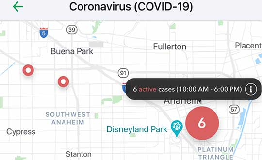
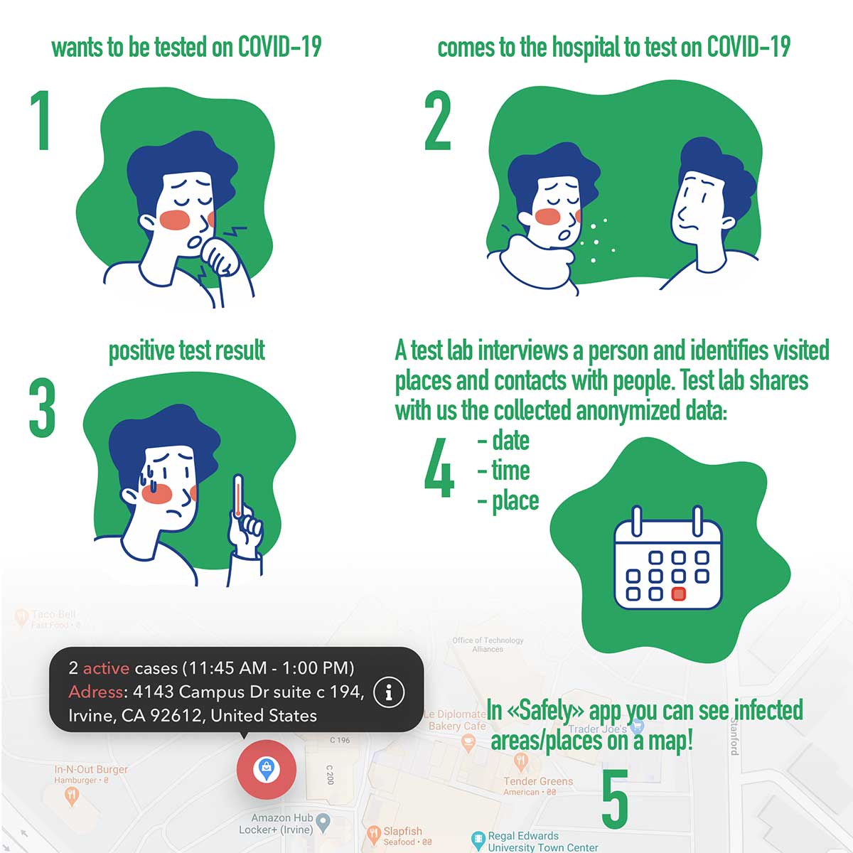
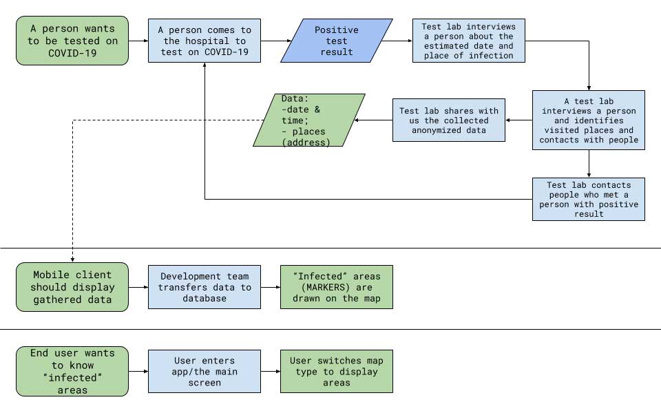
Vesedia Mobile Technologies is offering to deploy its location platform to help control the COVID-19 pandemic through tracking and dissemination of information about “at risk” infection areas and places, and times when they were known to have infection — a process referred to as contact tracing.
Vesedia is a technology startup with a suite of mobile apps for children and family safety based on a location-sharing platform and location-tracking artificial intelligence (AI).
“The platform would warn people that passed through these places at matching times,” explained Ruslan Shalaev, co-founder and team leader, Vesedia. Shalaev developed a popular app for family safety: Safely – Family Location; and serves as a lead research on user-location monitoring AI in an academic partnership with Binghamton University and Lviv National University.
The Safely – Family Location app could be used to disseminate data on infection areas, and access to the API would be provided for other application developers and sites, Shalaev said.
The platform would be applicable after the initial pandemic is contained. “It would help with restarting the economy and resuming normal business operations by providing a mechanism to track, control and suppress new outbreaks,” Shalaev said.
Data Sources
Under the plan, people that test positive to COVID-19 would be asked to provide information about public places they visited in the preceding days, and at what times. Individuals that provide the information can confirm that it’s accurate from their phone location history.
The information would be anonymized by healthcare officials, and entered into a database that would be publicly accessible via a website and mobile app.
Image: Vesedia
Mobile App
The mobile app aspect is especially valuable from information dissemination standpoint, because other people in “at risk” areas can receive automated alerts to self-quarantine and get tested based on their device location history.
The app is ready and available for download in Google Play and Apple App Store.
Image: Vesedia
Image: Vesedia
Workflow diagram
Workflow diagram. (Image: Vesedia)
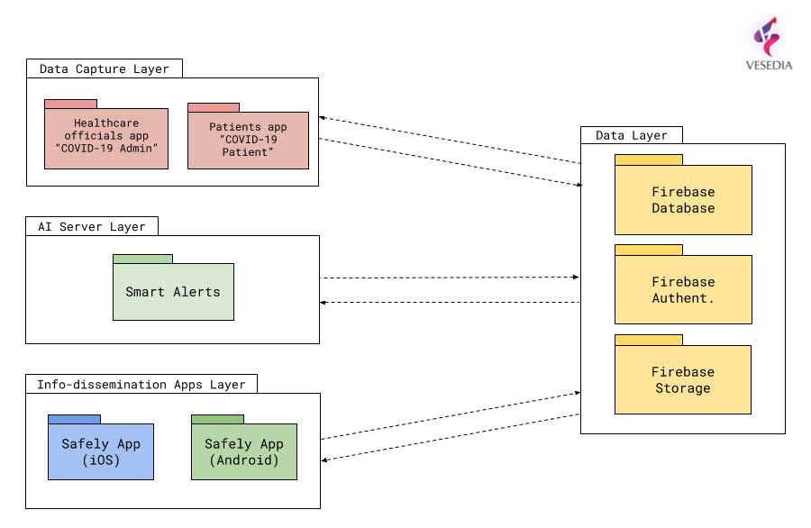
System architecture
System architecture. (Image: Vesedia)
Approach validity
The approach has been successfully applied in Singapore, but without active alerts, with dissemination of information being done manually. The Singapore government was able to contain the virus without shutting down businesses, schools, public transit and restaurants.
Vesedia location apps
Vesedia is a tech startup founded in 2016 by SUNY Binghamton Computer Science graduates. It developed SmartAI location tracking and sharing platform. Its apps include Safely – Family Location, Virtual Nanny, MeetCity – Live Events, Blind Date, Sponter – Social Network in partnership with Lviv National University and Binghamton University. The apps are available for download in the Google Play and Apple App stores.
Vesedia research on “Location-Based Behavioral Patterns Modeling” was published at Institute of Electrical and Electronics Engineers – Intelligent Data Acquisition and Advanced Computing Systems (IEEE/IDAACS) conference in Metz, France in 2019.
The North Carolina Department of Transportation (NCDOT) is working with public and private partners to launch three projects using drones to aid in COVID-19 relief efforts. According to NCDOT, the initiative will be launched in May.
For the first project, Novant Health and Zipline are proposing to deliver personal protective equipment and other medical equipment across Novant Health’s medical campuses in the Charlotte area.
For the second project, UPS Flight Forward and Matternet are proposing to work with a Winston-Salem hospital on an operation to use drones to take healthcare equipment, medicine and personal protective equipment to medical providers. UPS Flight Forward, which earned the necessary federal certifications to operate a drone airline, has an ongoing drone delivery service at WakeMed’s main campus in Raleigh, NCDOT said.
Finally, for the third project, Flytrex is proposing to deliver food from multiple restaurants in a shopping center to neighborhoods in the Holly Springs area.
The first two programs are aimed at reducing the strain on medical supply chains, and the third will make it easier for people to follow the stay-at-home order. According to NCDOT, officials will use data collected during the project to determine how this technology can be used in other areas of the country.
“North Carolina has been a leader in demonstrating how drones can help people in times of crisis,” said State Transportation Secretary Eric Boyette. “We look forward to putting this technology into productive use as we work to help citizens and medical professionals during the COVID-19 pandemic.”
Funding for the individual drone missions is coming from private partners, while NCODT is coordinating the initiative.
New hyperlocal business directory ZoomBusiness designed to help Main Street businesses across North America engage with local residents
GIS Planning has launched an online tool that enables local businesses across North America to communicate with customers for free in real time.
ZoomBusiness, created in response to the COVID-19 pandemic, is an interactive, mobile-responsive mapping directory for communities that ensures customers can find open restaurants, stores and services in their region at no charge.
Businesses can list themselves for free on their local ZoomBusiness site, hosted by economic development organizations like cities, towns, counties or chambers of commerce. The businesses can provide customized details including websites, modified hours, delivery or curbside pickup options, promotions and gift card stimulus programs.
Residents can search for area businesses by categories, including grocery stores, pharmacies, banks, health facilities, hardware stores, pet stores and automotive shops, among others.
North America deployment
Local ZoomBusiness sites have already been deployed in more than 20 communities across North America during its soft launch, including regions of eastern Pennsylvania;, the City of Columbia, South Carolina; the state of Wyoming (which has listed more than 600 businesses on the directory); and Abbotsford, British Columbia.
“We created ZoomBusiness after realizing that small businesses need new, accurate ways to communicate that they are still open to their customers, given that social distancing requirements, product availability and operating hours are changing by the day,” said Pablo Monzon, managing director and co-founder, GIS Planning. “Our development team has created an intuitive tool to index and map business information across North America in real-time, and we believe it will be an enormous resource for the communities we serve.”
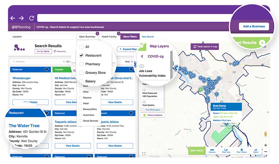
ZoomBusiness is a simple-to-use data tool, powered by Google Maps, using various layers for precise queries. Businesses are prompted to directly enter information on their current status and the content is verified by the organization hosting the GIS tool.
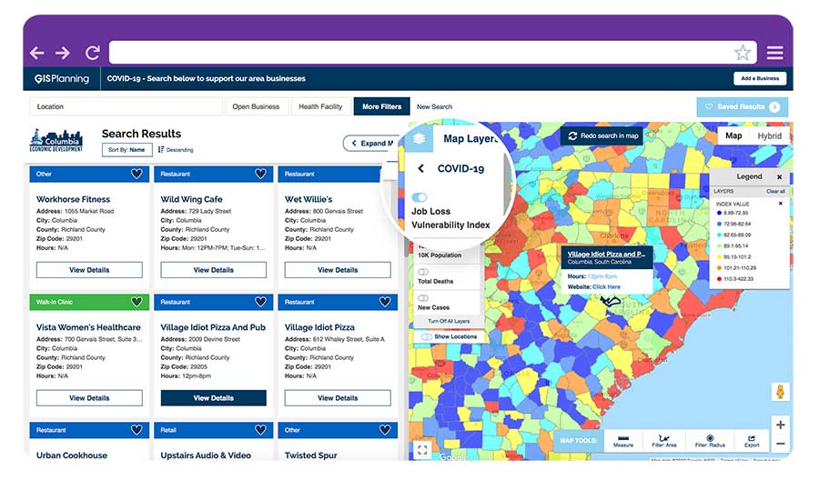
GIS Planning also added free map layers, including a COVID-19 case map updated daily by the New York Times, and a job-loss vulnerability index using recent employment data from Chmura.
Screenshot: GIS Planning
Columbia, South Carolina
The city of Columbia features 180 businesses on ZoomBusiness, helping residents discover delivery and curbside food options. That number is expected to quickly rise to more than 300 as business owners input data. Columbia will continue to promote safe and responsible “Shop Local” practices, Coleman added, in hopes that residents will take advantage of the service and support local businesses.
“Through our work with GIS Planning, we’ve been able to take our list of open restaurants and businesses and integrate it into the available properties map on our website,” said Ryan Coleman, director of the City of Columbia Office of Economic Development. “During this crisis, local businesses need every advantage we can give them, and this is another tool in their arsenal in helping to mitigate the negative impact of COVID-19.”
Abbotsford, British Columbia
The new solution has also made an impact in Canada, including the City of Abbotsford, British Columbia, which is promoting 130 businesses ranging from grocers to auto shops and medical suppliers.
“This is a resource that fills an urgent need. The long-term health and security of our businesses depend, in part, on the decisions we’re making right now,” said Kim O’Sullivan, City of Abbotsford’s economic development coordinator. “ZoomBusiness allows owners to communicate directly with their customers, many of whom would frequent these businesses, even online, if they knew they were able to do so.”
ZoomBusiness clients are given a unique link to their region which is then shared across organizational websites and social media to reach residents.
“Main Street businesses are truly the lifeblood of a community,” said Alissa Sklar, vice president of marketing for GIS Planning. “According to FEMA, up to 40% of small businesses never reopen after a major disaster. With ZoomBusiness, we want to help make sure the local restaurants, retailers and service providers that define local communities are still there to serve area residents when this pandemic is over.”
GIS Planning has made its ZoomBusiness tool free for its existing economic development clients (those using its investment attraction map, ZoomProspector); it is also available to new clients for a nominal fee. Prices are indexed to population size to keep them affordable for all communities. New clients can also be set up and ready to launch the tool within one day.
Following the COVID-19 recovery, data experts at GIS Planning forecast continued use of the directory to promote small and medium-sized businesses across North America.
New hyperlocal business directory ZoomBusiness designed to help Main Street businesses across North America engage with local residents
GIS Planning has launched an online tool that enables local businesses across North America to communicate with customers for free in real time.
ZoomBusiness, created in response to the COVID-19 pandemic, is an interactive, mobile-responsive mapping directory for communities that ensures customers can find open restaurants, stores and services in their region at no charge.
Businesses can list themselves for free on their local ZoomBusiness site, hosted by economic development organizations like cities, towns, counties or chambers of commerce. The businesses can provide customized details including websites, modified hours, delivery or curbside pickup options, promotions and gift card stimulus programs.
Residents can search for area businesses by categories, including grocery stores, pharmacies, banks, health facilities, hardware stores, pet stores and automotive shops, among others.
North America deployment
Local ZoomBusiness sites have already been deployed in more than 20 communities across North America during its soft launch, including regions of eastern Pennsylvania;, the City of Columbia, South Carolina; the state of Wyoming (which has listed more than 600 businesses on the directory); and Abbotsford, British Columbia.
“We created ZoomBusiness after realizing that small businesses need new, accurate ways to communicate that they are still open to their customers, given that social distancing requirements, product availability and operating hours are changing by the day,” said Pablo Monzon, managing director and co-founder, GIS Planning. “Our development team has created an intuitive tool to index and map business information across North America in real-time, and we believe it will be an enormous resource for the communities we serve.”
ZoomBusiness is a simple-to-use data tool, powered by Google Maps, using various layers for precise queries. Businesses are prompted to directly enter information on their current status and the content is verified by the organization hosting the GIS tool.
GIS Planning also added free map layers, including a COVID-19 case map updated daily by the New York Times, and a job-loss vulnerability index using recent employment data from Chmura.
Screenshot: GIS Planning
Columbia, South Carolina
The city of Columbia features 180 businesses on ZoomBusiness, helping residents discover delivery and curbside food options. That number is expected to quickly rise to more than 300 as business owners input data. Columbia will continue to promote safe and responsible “Shop Local” practices, Coleman added, in hopes that residents will take advantage of the service and support local businesses.
“Through our work with GIS Planning, we’ve been able to take our list of open restaurants and businesses and integrate it into the available properties map on our website,” said Ryan Coleman, director of the City of Columbia Office of Economic Development. “During this crisis, local businesses need every advantage we can give them, and this is another tool in their arsenal in helping to mitigate the negative impact of COVID-19.”
Abbotsford, British Columbia
The new solution has also made an impact in Canada, including the City of Abbotsford, British Columbia, which is promoting 130 businesses ranging from grocers to auto shops and medical suppliers.
“This is a resource that fills an urgent need. The long-term health and security of our businesses depend, in part, on the decisions we’re making right now,” said Kim O’Sullivan, City of Abbotsford’s economic development coordinator. “ZoomBusiness allows owners to communicate directly with their customers, many of whom would frequent these businesses, even online, if they knew they were able to do so.”
ZoomBusiness clients are given a unique link to their region which is then shared across organizational websites and social media to reach residents.
“Main Street businesses are truly the lifeblood of a community,” said Alissa Sklar, vice president of marketing for GIS Planning. “According to FEMA, up to 40% of small businesses never reopen after a major disaster. With ZoomBusiness, we want to help make sure the local restaurants, retailers and service providers that define local communities are still there to serve area residents when this pandemic is over.”
GIS Planning has made its ZoomBusiness tool free for its existing economic development clients (those using its investment attraction map, ZoomProspector); it is also available to new clients for a nominal fee. Prices are indexed to population size to keep them affordable for all communities. New clients can also be set up and ready to launch the tool within one day.
Following the COVID-19 recovery, data experts at GIS Planning forecast continued use of the directory to promote small and medium-sized businesses across North America.
The Esri User Conference, which usually takes place in San Diego in July, will this year be held virtually.
“As a result of the coronavirus disease 2019 (COVID-19) crisis, we are making the decision to move the 2020 Esri User Conference in San Diego to a virtual format. This is a great disappointment to me personally, as I know it will be for many of you,” Esri CEO Jack Dangermond told those planning to attend in an April 22 e-mail.
The following is an outline of Esri’s current plan, with more information available in the Esri UC FAQs:
The event will take place July 13–15, 2020.
The plenary session, technical workshops and Esri Showcase will be virtual, featuring many demonstrations and live discussions during the conference.
There will be many opportunities for networking, collaboration and real-time interaction with Esri experts and staff.
User presentations and the map gallery will be featured digitally.
A library of recorded sessions and demos will be created and kept available as an ongoing resource.
Registration will be complimentary for all Esri customers who are current on their maintenance or subscription.
“Forty years ago this month, we had our first User Conference in Redlands, California, with only a handful of participants,” Dangermond wrote. “While initially no one was quite sure of what the outcome would be, the event started an ongoing tradition where Esri and our users would come together, share our work, learn and create a community of common interests.
“That first meeting on the Esri campus provided the groundwork for the annual event at which thousands of professionals from every corner of the globe meet one another, share inspiring examples of work and learn from each other’s experiences.
“While we can’t replicate the experience of being together in person, we will do our best to create an amazing event that will continue to move you and our community forward. One of the benefits of going with a virtual format will be that organizations will be able to send an unlimited number of attendees.”
Sand Studio, a mobile device management (MDM) solution provider, is offering AirDroid Business Geofencing, a location-based solution for businesses to monitor and track device location, automate tasks and receive notification alerts in one place.
With geofencing, organizations that have vehicles, personnel or valuable assets in the field can use tracking data and workflows to enhance security and optimize operational efficiency.
Geofencing integrates seamlessly with AirDroid Business’ easy-to-use yet powerful device management solution, enabling IT managers to apply different configurations to existing or newly created device groups at any time.
Adding to the existing location tracking feature, AirDroid Business Geofencing brings new capabilities like geofencing, path tracking, automated workflow, logs, and notification management.
Geofencing: Location-based technology where a customizable virtual fencing zone can be created for devices that are coming in and out of a predefined area on a map. Single devices or groups of devices can be added to multiple profile zones for different scenarios, which provides flexibility and more control over deployed devices.
Path Tracking: Admins can track a device and see its extensive path history. This allows for an in-depth analysis by combining time and location. For instance, admins can track a delivery truck and see if it has deviated from the assigned route, analyze the data, and improve operational efficiency.
Workflow, Logs and Notifications: Workflows work together with geofences. Triggered by a device entering or exiting a geofence, workflow will activate automated tasks such as device locking and factory reset. Working side-by-side with workflow is log management, where point of time, device activity, device status and events can be filtered to spot abnormal activities or insights for improvements.
“With mobile transformation continuing to take place in every industry, more businesses and organizations are deploying mobile devices in the field. However, they are also faced with the challenge of managing these devices,” said Anson Shiong, CEO of Sand Studio. “To help with this transition, AirDroid Business’ focus on remote device management and the new geofencing solution will help businesses maintain security and operational efficiency. These new features are designed to monitor and track remote devices with precision from anywhere in the world.”
Geofencing is beneficial to a range of industries such as medical and health institutions, public agencies who need to track people at risk in situations like the coronavirus outbreak, transportation and logistics companies that need specific details on fleet activity, corporations that disseminate company devices with confidential information, food delivery services and more.
The new tracking capabilities ensure consistent employee productivity levels as well as enhance security by knowing where the employees and devices are while also enabling confidential materials to be remotely wiped from a device when outside of the safety zone.
GPS World is conducting a short survey to shed light on the impact of COVID-19 on the GNSS/PNT industry.
The short survey covers topics such as
changes in daily work habits
communication methods with staff, technology partners and clients
how each core sector is responding to the coronavirus pandemic
how we are all trying to remain productive despite social-distancing directives.
GPS World is committed to providing the most up-to-date coronavirus resources for the GNSS/PNT industry. We value your thoughts and opinions and would love to include your thoughts on the subject through our survey.
Results of the survey will be shared in the June issue of GPS World magazine.
With impacts related to the coronavirus developing on a daily basis, GPS World may reach out again in the near future to hear how you’re doing. As always, thank you for your continued support.
Draganfly conducted its first series of U.S. pandemic drone test flights in Westport, Connecticut.
Draganfly’s pandemic drone technology is being tested by the Westport Police Department as a new “Flatten the Curve Pilot Program.” According to Draganfly, this initiative is a collaboration of technologies developed by Draganfly, Vital Intelligence, a healthcare data services and deep learning company, and the University of South Australia.
Westport is located in Fairfield County, which has more than 17,550 confirmed cases of COVID-19. Fairfield County is adjacent to New York City, which has the most confirmed cases of coronavirus in the United States.
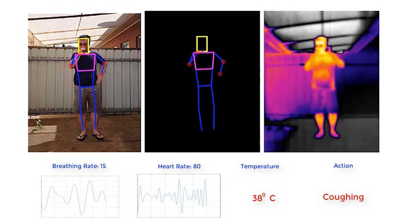
Image: Draganfly
Westport is deploying the technology and data tools to enhance town services, advance public safety, promote the efficient use of taxpayer dollars, engage residents and encourage growth in the local economy.
The pandemic drone will be equipped with a specialized sensor and computer vision systems that can display fever/temperature, heart and respiratory rates, as well as detect people sneezing and coughing in crowds, and wherever groups of people may work or congregate. The technology can accurately detect infectious conditions from a distance of 190 feet, as well as measure social distancing for proactive public safety practices, Draganfly said.
Westport specifically plans to use the drone technology to help protect potential at-risk groups, crowds gathering at the town and state-owned beaches, train stations, parks and recreation areas, shopping centers and other areas where people tend to gather.
“One of the major problems for cities and towns like Westport in managing and responding to a pandemic like the COVID-19 virus, is finding out who could be infected and how widespread the disease has spread,” said Jim Marpe, Westport first selectman. “One way to do this is to look for underlying symptoms. By teaming up with Draganfly and the UniSA team, led by Defence Chair of Sensor Systems Professor Javaan Chahl, we are able to remotely look at valuable lifesaving data and better manage current and future health emergencies.”
Draganfly‘s pandemic drone software uses biometric readings in its analysis process. The software can be used to understand patterns within a population to allow users to react quicker to ongoing events or new potential health threats, Draganfly added.
Draganfly manufactures UAVs and UAS, serving the public safety, agriculture, industrial inspections and mapping and surveying markets.
Small businesses, including many surveyors, are being hit particularly hard by the current economic situation caused by the measures required to fight the COVID-19 pandemic because most of them do not have large cash reserves.
The CARES Act, signed into law on March 27, contains $349 billion to keep small businesses afloat. The funds are administered by the Small Business Administration (SBA) through participating banks.
Hundreds of thousands of borrowers have been approved for, or received, aid under the so-called Paycheck Protection Program, meant to give small businesses loans that would be forgiven if they were used to pay employees, rent, or mortgage principal. The program is one of four that the SBA is administering as part of the CARES Act.
The other three are the Economic Injury Disaster Loan (EIDL) loan advance, which will provide up to $10,000 of economic relief to businesses that are currently experiencing temporary difficulties; the SBA Express Bridge Loans, which enables small businesses who currently have a business relationship with an SBA Express Lender to access up to $25,000 quickly; and the SBA Debt Relief, which provides a financial reprieve to small businesses during the pandemic.
These programs — an unprecedented challenge for the SBA, which is already struggling with a surge in coronavirus-related loan applications through other programs such as its disaster loan program — were marred by technical and logistical glitches from the start.
On April 16, while many small-business owners were desperately trying to apply for loans, the SBA ran out of the relief money. Its website’s COVID-19 page announced: “SBA is unable to accept new applications at this time for the Paycheck Protection Program or the Economic Injury Disaster Loan (EIDL)-COVID-19 related assistance program (including EIDL Advances) based on available appropriations funding. EIDL applicants who have already submitted their applications will continue to be processed on a first-come, first-served basis.”
As of press time, Congress and the White House are negotiating the possible release of additional rescue funds.