Trimble continues to increase its footprint to deliver high-accuracy positioning correction services
Photo: Trimble
Trimble has acquired MidStates VRS, a network previously owned by Butler Machinery and Frontier Precision. The addition of the network, in North and South Dakota, increases the footprint of Trimble’s VRS Now GNSS corrections service to cover more than one million square miles in North America. Financial terms were not disclosed.
As part of an ongoing expansion strategy, the new coverage for the VRS Now subscription service helps users in more places achieve high-accuracy positioning to increase productivity, reduce operational costs and improve safety.
The correction service is designed for professionals in agriculture, geospatial and construction as well as emerging autonomous applications including lane-keeping for passenger vehicles, vehicle-to-everything (V2X) position identification and unmanned aerial system guidance.
Adding 105,000 square miles of coverage, the acquisition expands Trimble’s VRS Now network to be one of the largest in North America — over one million square miles, contributing to Trimble’s shift toward a software, services and subscription business emphasis.
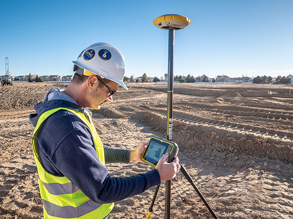
When using the Trimble VRS Now service, land and construction surveyors, GIS professionals and farmers — with a Trimble or third-party commercial GNSS receiver — can leverage instant high-accuracy corrections delivered via cellular network to improve productivity.
Enabling users to work without a GNSS base station, the service is cost-effective and simple to use. It is ideal for a variety of applications that require sub-inch level accuracy and is an important component of the connected construction site and connected farm workflows.
“The MidStates VRS network covers significant farmland, oil fields and rapidly developing urban areas, providing farmers and surveyors in the region with the real-time GNSS correction services they need to improve their day-to-day work,” said Patricia Boothe, senior vice president of Trimble’s Autonomy Sector. “The purchase of the MidStates network demonstrates Trimble’s ongoing commitment to provide a wide range of correction services for autonomous solutions — delivering unmatched access to fast, reliable and highly accurate positioning in more areas than ever before.”
Trimble networks are supported by a global network operations team made up of GNSS system engineers, geodesy experts and IT professionals. The team monitors the networks 24/7 from operation centers located on three continents, providing consistent and reliable service uptime and performance integrity.
Trimble VRS Now. The correction service offers instant access to centimeter-level positioning tailored to the users’ geographic location; the service is always on wherever and whenever needed within the network coverage area. With no base station or setup required, it is cost-effective, efficient and simple to use.
VRS provides positioning professionals with instant access to real-time kinematic (RTK) and post-processing (PP) corrections utilizing a network of permanent (fixed) continuously operating reference stations (CORS).
Trimble-owned VRS networks are accessible now in areas throughout the U.S. and Canada as well as Eastern Australia and Tasmania, France, Belgium, the Czech Republic, Estonia, Germany, Great Britain, Ireland, Luxembourg, the Netherlands, Sweden and New Zealand.
Thirty years ago, more than a decade before most people had even heard of GPS, receiver manufacturers and surveyors were already improving on it by providing and using correction services to compensate for errors in the system—including clock drift, orbit errors, signal errors, atmospheric errors and multipath.
Today, dozens of public and commercial correction services enable users to achieve accuracies of decimeters, centimeters or even millimeters. Also, many GNSS processing services correct measurements taken in the field using data from reference points. Increasing positioning accuracy has become the cornerstone of modern GNSS practice.
The current boom for correction services is driven mostly by the demand for high accuracy from the automotive industry (including the development of self-driving cars), as well as smart consumer devices and various forms of automation. Automotive companies and telecoms are deploying infrastructure around the globe to provide centimeter-level positioning. GNSS satellites also can transmit corrections directly, as the Japanese CLAS service from the QZSS constellation does, and Galileo’s High-Accuracy Service (HAS) soon will. To compensate for receiver-side issues — multipath, jamming and spoofing — some GNSS receivers also incorporate advanced positioning algorithms.
Clock and orbit errors are specific to each satellite; they do not depend on the position of the receiver. But atmospheric errors are introduced when the signal travels from the satellites to the user. Reference stations (base stations) of GNSS receivers installed at fixed and precisely surveyed positions provide corrections that compensate for both sets of errors to the rovers carried by field crews. When connected, reference receivers spread over a geographic area form reference networks, such as that of continuously operating reference stations (CORS). Achieving maximum accuracy requires initializing the receiver, which can take a few seconds to several minutes, depending on the type of corrections.
Established and new methods
Two established methods have been used for decades.
Real-time kinematic (RTK). In RTK, a receiver obtains correction data from a single base station or a local reference network in the same area.
Precise point positioning (PPP). While accessible from anywhere in the world, receiver initialization for PPP can take up to 30 minutes. Also, a few PPP correction services only provide corrections for satellite clock and orbit errors and not for atmospheric errors, limiting users to a lower accuracy level than with RTK.
Hybrid PPP-RTK. In recent years, new methods have emerged. Hybrid PPP-RTK combines near-RTK accuracy and quick initialization times with the global access of PPP. It relies on a network of reference stations within about 150 kilometers of each other. The stations collect GNSS data and calculate both satellite and atmospheric correction models. The network then broadcasts these corrections via internet, satellites or cellphone towers to subscribers, who can use them to achieve sub-decimeter accuracy.
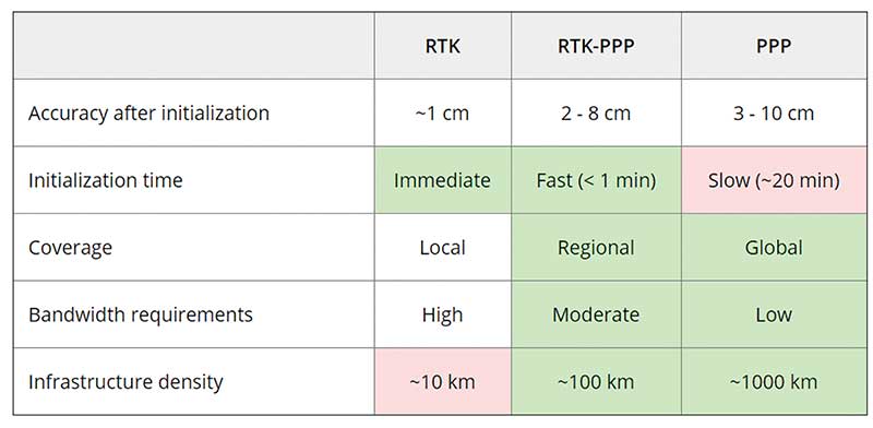
Each of these methods has advantages and disadvantages (see table 1). RTK, which relies on communication between the user and the local correction service, provides centimeter accuracy over small areas. PPP-RTK and PPP broadcast corrections and require a lighter infrastructure, making them scalable for mass-market and industrial applications. The new services are cheaper and more user-friendly than traditional correction services.
TABLE 1: Differences of various correction methods. (Chart: Septentrio)
CORS/VRS
Traditional reference networks — often called CORS or virtual reference station (VRS) networks — have long been a source of differential GPS (DGPS) and RTK corrections, mainly for surveying and mapping applications, which require high accuracies.
“Most CORS in the United States are strictly for providing high-accuracy correction data to GNSS users who need to know their position to less than an inch,” said Alex Ngu, applications engineer at Trimble. “However, some — like Utah’s TurnGPS network and the North Carolina Geodetic Survey (NCGS) — have considered dabbling in using them to double up for weather monitoring.” In some regions, such as Japan and Washington state, CORS are also used to study plate tectonics and provide early warning of earthquakes.
CORS receivers often operate in remote locations and may be powered by solar panels. Therefore, they require low power consumption and the ability to configure, run and update remotely. They also need to archive on-board measurements and withstand harsh environments.
Changes in the market
As the market for GNSS corrections changes, so does the role of CORS networks. They are increasingly used for industrial automation that needs centimeter accuracy, including construction and agriculture. “Now, due to the growth in autonomous systems, such as autonomous cars, people are looking at corrections in a completely different way and with more focus on mass markets,” said Gustavo Lopez, market access manager at Septentrio. Septentrio lets customers choose which correction service to use.
“CORS/VRS networks will keep focus on performance and on adding constellations and signals, but nothing major is expected to happen in these traditional systems,” Lopez said. They will continue to exist because they focus on centimeter-level accuracy for survey, construction, mining, machine control and precision agriculture. “What will really change the market are these new services with 10-cm to 20-cm accuracies, which also offer a new way of delivering the data, namely broadcasting rather than using two-way communication methods.” This helps with adoption by emerging applications, Lopez said.
He predicts that applications needing 10- to 50-centimeter acurcy will migrate to cheaper services, including new consumer applications, advanced driver-assistance systems (ADAS), professional applications such as robotics, UAVs, logistics and internet of things (IoT) applications.
Mobile technologies adopting dual-frequency chipsets also will need correction services. “We will see more and more telecoms interested in providing GNSS corrections as a service, as is already the case in Asia and Europe,” Lopez said. “A few CORS/VRS networks will try to capture part of this emerging applications market by reusing their technology or partnering with other companies to provide a more transparent solution.”
One might think that the rapid expansion of the market for corrections would make it possible for traditional CORS networks to make 1-cm accuracy available at a much lower price. The roadblock is high infrastructure costs, Lopez explained. CORS/VRS networks are expensive to maintain because they require a high density of stations. New services that use broadcasting technology and PPP-RTK positioning modes rely on less dense networks.
New uses for old CORS
A key benefit of a VRS is that performing RTK positioning across the area it covers does not require guarding a separate GPS base station. Using VRS, the CORS network acts essentially as a continuous reference station within the entire network, enabling RTK positioning using a single rover in the field.
Randy Osborne, VRS network manager at Louisiana State University’s Center for GeoInformatics, reports a growth in new applications beyond surveyors. VRS expanded to precision agriculture, and then into applications such as lidar and UAVs. “We are also seeing strange applications that we never thought of. For example, plumbing companies use it to navigate underground from a truck that has a position on the network, and then they vector from the truck underground into pipelines,” Osborne said. Subscribers also include companies performing survey work for fracking and petrochemical projects.
OSR vs. SSR
Most GNSS correction services are based either on the observation state representation (OSR) or on a state space representation (SSR) of the errors. OSR and SSR use different techniques, delivery mechanisms and core technologies.
OSR. Legacy GNSS correction service providers supply OSR correction services; examples are RTK and networked RTK (RTN). They rely on transferring corrected GNSS observations from the nearest reference station to the rover using a standardized format. They focus on a geographic region and target surveying, machine control and precision agriculture, providing centimeter-level accuracy up to about 30 kilometers of the nearest reference station. Because these services require bi-directional communications and large bandwidth, it is hard to ramp them up for mass-market applications.
SSR. By contrast, new players in the market for correction services, as well as some of the larger legacy ones, provide SSR correction services. SSR uses a network of reference stations to model major errors over large areas. They then transfer this model to the rovers, which create local error models and apply them to their GNSS observations. Depending on the service, accuracy ranges from less than 5 cm to 20 cm, convergence times from 10 seconds to 30 minutes, and coverage from continental to global. Because SSR corrections are broadcast, they can be more easily distributed through internet connections and L-band satellite channels. Because all the rovers rely on the same stream of GNSS correction data, SSR services work well for mass-market applications. The growth in SSR technology is driven mainly by the needs of the automotive industry but is sufficiently generic for adoption in other markets.
The challenge of vertical accuracy
A CORS receiver stands atop the Old River Auxiliary Control Structure, a floodgate system in a branch of the Mississippi in central Louisiana. (Photo: Trimble)
While OSR and SSR have comparable accuracies on a horizontal plane, they differ greatly in their vertical accuracy and initialization times, Osborne said. “When we look at CORS for active control and positioning in the National Spatial Reference System, we are mainly trying to get a handle on the vertical part, as it is the hard problem to solve,” he said.
High-precision vertical accuracy is a challenge for any GNSS-based method. Conventional surveying is still the gold standard. With differential leveling, like with digital levels, results in millimeters are possible. Post-processed GNSS, using data from a good geometry of CORS or base data, can yield results under 2 cm vertical, as can real-time OSR methods like RTK and RTN. SSR solutions, like PPP and hybrids, are presently achieving 5 cm at best. An Achilles heel for SSR vertical solutions is the lack of data for localized sources of error, like tropospheric conditions. Semi-dense networks of CORS can feed ionospheric data to speed PPP convergence, but not the level of tropospheric data needed to match the vertical results that OSR and conventional methods can.
Trimble
Trimble GNSS base-station receivers have been used for 40 years on every continent, according to the company. Today, products in use as CORS stations typically are Alloys, NetR9s and NetR5s. The company operates more than 300 networks worldwide, incorporating more than 5,000 CORS receivers.
Trimble offers a full spectrum of solutions, services and subscriptions related to CORS networks. They range from supplying CORS software, hardware and services, to providing network management services to run a secondary backup system for a network, or even operating a network on behalf of its owner. For those who just want a high-accuracy correction to support their surveying, GIS or machine guidance and control work, “Trimble operates one of the largest CORS networks in the world to which users can subscribe — Trimble VRS Now, Trimble RTX and OmniSTAR services,” Ngu said.
Feature photo:
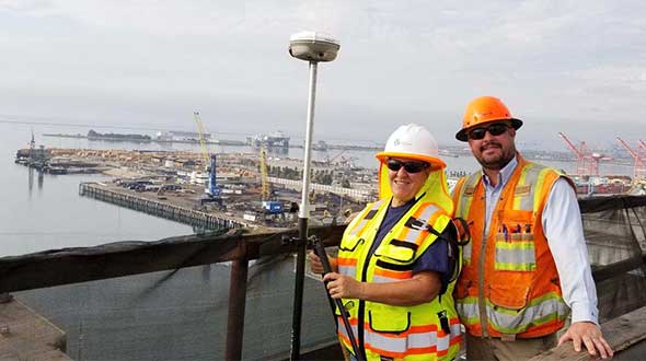
In Long Beach, California, correction services support the 250-foot-high Gerald Desmond Bridge project. Trevor Rice (left), president of D. Woolley & Associates, joins Kimberley Holtz, director of survey, Port of Long Beach. (Photo: Trimble)
When someone imagines the Australian outback, they’re picturing Australia’s largest state, Western Australia (WA), which occupies an entire third of the continent.
Nearly all WA residents live in Perth, with the rest of WA reminiscent of the United States’ historic Wild West — sparsely populated towns with little infrastructure. That wild beauty and remoteness can also make surveying a less-than-beautiful experience.
“The outback of WA is a real test on my adaptability and logistics skills,” said Phil Richards, a professional surveyor and associate director with Perth-based RM Surveys. “It can take 1.5 days to get to your first site and once there, you’re totally isolated with no resources — and climate conditions that can range from 0 to 50 degrees Celsius. The sparse, rugged road systems make navigating anywhere a long journey. And if the weather turns bad on your job and you didn’t plan well, you could be completely stranded.”
Technological challenges that add to the complexity: limited mobile phone service, time-consuming RTK base station setups, inconsistent RTK cellular or radio communication, and geodetic control points that are difficult to access.
Advances in precise point positioning (PPP) technology, however, have been helping to resolve these obstacles and enable surveyors to optimize their real-time productivity without sacrificing accuracy. For Richards, who specializes in remote surveying work, this modern GNSS enhancement has helped bring a little tameness to the wilds of WA, enabling him to increase data collection efficiencies, reduce costs and boost the company’s bottom line.
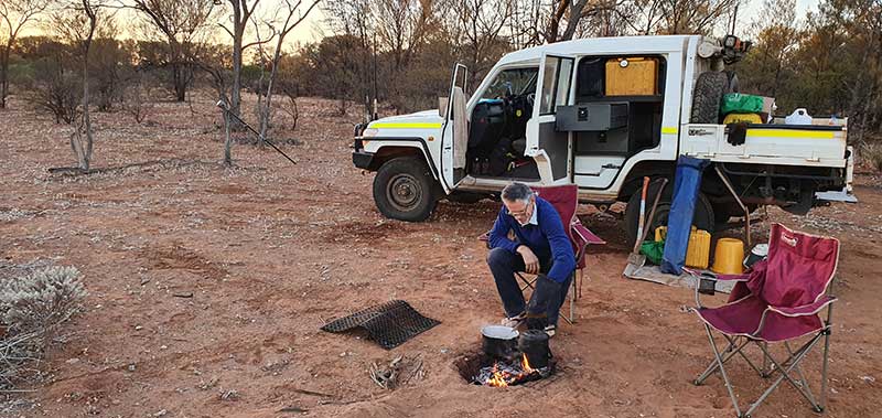
Camp breakfast: The R10 receiver rests on a spur while Phil Richards dines out. (Photo: Trimble)
The case for a new approach
With his aptitude for remote surveying, much of Richards’ project work in WA has been in support of heavily active mining companies. For example, for the past 15 years, one iron ore producer has contracted him to travel more than 600 kilometers from Perth to measure exploratory drill hole collars. Drill collars, the remnants of drilling activity, are 3-millimeter-thick segments of PVC, about 150 mm in diameter, which protrude about 300 mm out of the ground, typically at a 60-degree angle. Measuring the center of that above-surface collar is a crucial stage in the exploration process to enable the client to develop a geological model of the mineral resource underground.
Managing 10 prospect sites across 300 km, the number of drill holes can vary from year to year, but there can be as many as 100 holes spread out over a few prospects at a time. Since 2007, Richards has been using Trimble R8 and, more recently, Trimble R10 GNSS receivers and RTK technology to acquire the drill-collar measurements.
On average, each prospect is 5 km by 2 km and has its own coordinate network. Depending on the number of collars and the distance to each, Richards would set up between two and nine RTK base stations on known control points to set project control. Using his Trimble GNSS receiver, he’d either drive or walk to each drill collar, set the foot of the range pole on the center of the collar at ground level, take a reading and record the measurement in Trimble Access field software on a Trimble TSC3 controller. Although the need for multiple base stations had added hours onto the projects, the RTK method consistently provided the needed accuracy.
X hits the spot
In 2015, the iron ore company restructured its mineral exploration program. Rather than drill numerous exploratory holes across a few prospects, the new focus was to drill fewer holes spread over the entire project area. That was going to be problematic for Richards’ traditional RTK routine.
“Previously, when it was predominantly surveying and less traveling, the RTK approach worked well for the project, even though setting up base stations is time consuming,” said Richards. “But when that switched to less surveying and more traveling, continuing with RTK was going to increase costs because each time I have to set up my base station, that’s an extra hour. If I have 10 drill-collar zones, that’s 10 hours. And if my base station is 10 minutes away, it adds more time and expense if I have a problem with it, or I can’t get a reliable signal, and I have to travel back to it to fix it or move it. The reduced number of collars and the increased distances between them required a more efficient method to make the project profitable.”
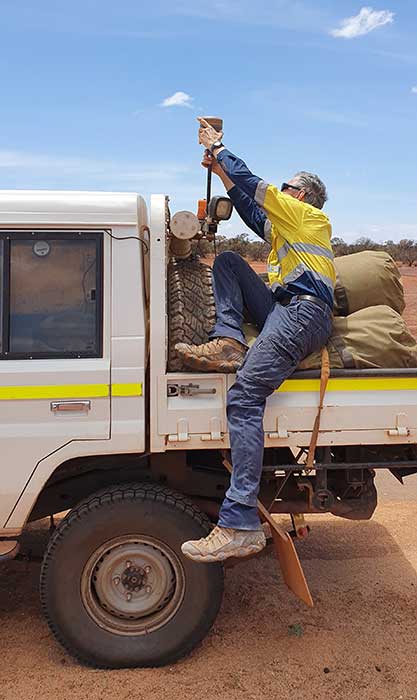
Taking the R10 off the vehicle mount. (Photo: Trimble)
Richards decided to test Trimble’s CenterPoint RTX correction service as an alternative. CenterPoint RTX is built on a network of GNSS tracking stations around the world that stream multi-frequency, multi-constellation data to the company’s network control centers. Advanced data processing algorithms analyze the three main error sources: satellite orbits, clock offsets and atmospheric effects, and develop models and correction data. This information is delivered to GNSS rovers via L-band satellite communications. The rover combines the correction data with its own satellite observations to produce accurate positions.
Richards ran five trials in conjunction with varied exploration surveys at test sites across 1,000 km of terrain. He took RTX measurements of survey control points with his R10 and compared them to the same positions acquired with RTK. Although the CenterPoint RTX can take up to 15 minutes to reach sub-2-centimeter horizontal accuracy in WA, Richards said the technology regularly delivered on performance. Most importantly, this technique enabled him to work without a base station and obtain real-time GNSS positions with centimeter accuracy even in isolated WA.
Integrating Trimble’s CenterPoint RTX into his workflows enabled Richard to use a single GNSS receiver system, much like working within the VRS networks available in the more populated areas of Australia.
Into the Outback
For the 2019 campaign, Richards and a colleague were contracted to acquire accurate 3D positions for 13 drill-collar holes stretched across two major prospects about 150 km apart. Their area of interest was 700 km northeast of Perth.
Within a 15-km-wide area, they had to acquire measurements for eight drill-collar holes. They calibrated the R10 receiver to the nearest control point to tie into the site’s coordinate system and moved through the area, methodically recording the positions of each collar hole. Despite the rough terrain, they finished both prospect sites in 1.5 days, compared to 2.5 days had they used RTK.
“Given the project format, with so much travel time and less surveying time, RTX is really the only way to do it,” Richards said. “It’s far quicker than setting up base stations — I saved 50% of the time using RTX on this campaign. I’m more efficient; I’m able to keep costs down; and I have the confidence in the system that I know I’ll deliver on accuracy. It’s hard to justify using any other method.”
Septentrio has unveiled the AsteRx-m2 Sx OEM board, which provides a GPS/GNSS receiver with always-on sub-decimeter accuracy without the need for additional correction service subscriptions.
With the AsteRx-m2 Sx, Septentrio is pioneering a novel approach to high-accuracy positioning. Its latest core GNSS technology is integrated with a sub-decimeter correction service enabling simple plug-and-play positioning solutions.
High-accuracy positioning is available directly out of the box as GNSS corrections are automatically streamed to the receiver. This significantly simplifies the receiver set-up process and eliminates the hassle of corrections service subscription and maintenance.
“This product marks a new step for GNSS technology towards convenience and ease-of-use,” said Danilo Sabbatini, product manager at Septentrio. “By integrating the correction service directly into the GNSS receiver, we are removing the hassle of positioning service set-up and maintenance from the user. This means faster set-up times for our customers and worry-free, always-on high-accuracy positioning throughout the receiver lifetime.”
The AsteRx-m2 Sx is an efficient positioning solution for small robots, aerial drones and automation applications. Its optimized size, weight and power (SWaP) means longer operation on a single battery charge and better value in the field, according to Septentrio.
Advanced anti-jamming technology AIM+ ensures robust and reliable operation in challenging environments, even in the presence of RF interference.
Septentrio is offering a free GNSS corrections webinar on July 8 at 5 p.m. CEST/ 8 p.m. PST.
Septentrio has entered into a commercial agreement with Sapcorda, a global provider of sub-decimeter GNSS corrections.
Through the collaboration with Sapcorda, Septentrio will pioneer an no-hassle corrections integration into a new line of products for the high-accuracy industrial market.
These new products will consist of Sapcorda’s SAPA Premium corrections integrated directly into Septentrio’s latest GNSS receiver technology. The result is sub-decimeter accuracy, which is available to users right out of the box. This significantly simplifies the user’s GNSS receiver set-up process and eliminates the hassle of corrections service subscription and maintenance.
Such GNSS receivers acquire corrections via internet as well as via satellite broadcast and deliver reliable, broadly available sub-decimeter positioning to high-volume industrial applications.
Sapcorda integration program
Sapcorda release its SAPA augmentation service integration program on May 14, following the launch of its SAPA Premium service. The integration program targets companies integrating GNSS chips or receivers and looking to enable their systems to perform in high-accuracy mode.
The program offers step by step service integration and proof of concept guidance for upgrading the integrators’ GNSS systems to deliver down to centimeter-level positioning accuracy.
The program also includes the offering of free service data, used to validate positioning performance on the target application. The program participants also receive commercial support for introducing the correction data on their marketed products.
The SAPA service is delivered using optimized data format and can be integrated by modern or traditional high-accuracy receivers compatible with open standards such as SPARTN and RTCM.
Sapcorda’s SAPA services are designed to bring high-precision GNSS positioning to mass market, as well as general industrial and automotive applications. The correction data stream is optimized for homogeneous performance and end-to-end data security with continental coverage in the United States and Europe.
The service data transmission also provides unmatched low bandwidth consumption, with broadcast transmission via direct IP connection or geostationary satellite signal (L-band).
Sapcorda was established in 2017 to provide an open approach to a safe, broadly available and scalable corrections service. By adding Sapcorda’s SAPA service to its corrections portfolio, Septentrio begins offering sub-decimeter accuracy with quick convergence time anywhere in the U.S. and Europe.
Autonomous vehicles, robots
“This collaboration allows both companies to bring innovative solutions, inspired by the growing market of autonomous vehicles and robots, to the high-accuracy industrial markets,” said Jan van Hees, business development director at Septentrio. “By integrating Sapcorda’s SAPA service into our products, we are completely removing the hassle of managing corrections for the customers. This means faster set-up times and worry-free, always-on high-accuracy positioning throughout the whole receiver lifetime.”
“At Sapcorda our focus is on providing a high-accuracy service suitable for demanding applications where both performance and safety is critical. This includes land robots, UAVs, logistic applications and autonomous vehicles,” said Botho Graf zu Eulenburg, CEO at Sapcorda. “Septentrio’s field-proven high-precision GNSS receivers and their focus on reliability and robustness aligns perfectly with our mission and the capabilities of our SAPA services.”
This broadens the range of Septentrio’s existing GNSS solutions, allowing the company to serve a wide range of customers with various requirements in terms of accuracy, operation location and scalability. Read Septentrio demystifies GNSS corrections for more about GNSS corrections and correction methods such as Sapcorda SAPA (PPP-RTK) service.
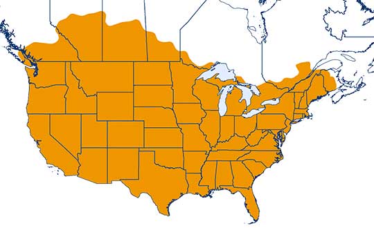
One-inch GNSS accuracy in under a minute, delivering seamless high-precision performance across the U.S. and southern Canada
Trimble has completed expanding its CenterPoint RTX Fast correction service, with coverage now spanning the contiguous U.S. and southern Canada. This expansion is central to Trimble’s vision to transform how and where users can leverage precision and accuracy.
Coverage of Centerpoint RTX Fast. (Image: Trimble)
Designed for autonomous applications in both on-road and off-road markets, the coverage and performance of the service enables industry professionals to re-think what is possible when using augmented positioning for improving safety, performance, productivity and operational efficiency.
The CenterPoint RTX Fast subscription service delivers horizontal positioning accuracy of 1 inch (2 centimeters) or less in under a minute, with the versatility of satellite or cellular delivery. This expanded coverage makes it the largest, high-performance GNSS correction network in the world, according to Trimble.
Base stations not required. The service encompasses more than 5 million square miles across North America and Europe. By using the service, said Trimble, farmers, land surveyors and GIS professionals can untether from the cost and complexities of GNSS base stations.
In addition, Trimble RTX Fast offers a single, continuous correction technology platform for enabling a broad range of safety-critical autonomous applications in markets such as automotive, agriculture and construction.
“This achievement is a major milestone in the continuous evolution of our correction service and autonomy strategy. We are delivering unmatched access to fast, reliable, highly accurate positioning in more areas than ever before,” said Patricia Boothe, senior vice president of Trimble’s Autonomy Sector. “Whether enhancing performance in the autonomy ecosystem or simplifying traditional mapping and surveying workflows, RTX Fast users can gain greater accuracy to improve productivity and operate safely — ultimately transforming the way they work and drive.”
CenterPoint RTX Fast subscriptions for Trimble RTX-compatible GNSS receivers are available through Trimble’s Authorized Business Partners or Trimble’s online store.
Klau Geomatics has launched MakeItAccurate, a global GNSS data correction and processing service.
MakeItAccurate takes data from any GNSS receiver on drone or survey equipment and makes it accurate. Users can now achieve centimeter (cm)-level accuracy without the need for base stations, real-time kinematic (RTK) links, data from Continuously Operating Reference Station (CORS) or other external inputs.
MakeItAccurate requires only the raw GNSS data from a drone to produce a highly precise trajectory and turn the traditional autonomous 3-5m GPS accuracy to 3-5 cm anywhere in the world.
In many parts of the United States, Europe, Japan, Australia and New Zealand, absolute accuracy of 2-3 cm XYZ will be achieved. In these areas, the KlauPPK processing engine applies sophisticated hybrid PPK/PPP algorithms, merging global PPP clock and orbit corrections with many distant CORS stations to achieve this high absolute accuracy.
The service enables enterprise drone operations to achieve high accuracy across their entire global operations with one repeatable workflow.
Sectors such as insurance, telecommunications and utilities can scale their operations without additional survey expertise and site-specific data constraints. The same process works for multiple operators on thousands of sites enabling consistent, high accuracy every time, the company said.
MakeItAccurate supports data from all GNSS manufacturers. Native support for DJI M 210v2 RTK or Phantom 4 RTK drones returns precise camera positions with centimeter-level accuracy. Other drones using external PPK GNSS products also can achieve highly accurate kinematic trajectories and camera coordinates.
A MakeItAccurate application programming interface (API) is available to push raw GNSS data to the processing engine and return highly accurate coordinates, with full reporting on the accuracy achieved for the entire trajectory or each camera event. GNSS hardware manufacturers can offer a custom service to add value to their products. Software developers offering artificial intelligence technology, photogrammetry processing or other outcomes that benefit from high accuracy can use the MakeItAccurate API.
GPS World spoke with Guillermo Perez-Iturbe, Trimble’s marketing director – agriculture, about the challenges for farms in adopting precision agriculture, including time, cost and connectivity issues in rural areas.
What technical challenges are faced in applying GNSS?
GNSS technology is at the center of precision agriculture and is one of the key enablers for the farm of the future. GNSS helps boost productivity, environmental sustainability and economic competitiveness.
Trimble’s GNSS agriculture solutions provide reliable, accurate positioning that can be tailored to meet specific needs, including different crops (broadacre vs. row crops) and activities (such as tilling, planting or fertilization). Trimble’s portfolio connects farming operations and includes guidance and steering; grade control, leveling and drainage; flow and application control; irrigation; harvest solutions; desktop and cloud-based data management; and correction services.
However, one of the challenges to fully realize the benefits of the future farm is connectivity. Typically, ag customers are in rural areas, where the available communications infrastructure to support Wi-Fi or cellular data communications varies widely. This can impact the ability to share information between field and office as well as between machines in the field.
But connectivity challenges have a lower impact on GNSS positioning. For example, farmers can leverage satellite-delivered corrections provided by Trimble RTX correction services using a compatible GNSS receiver and subscription service. This plays an important role in areas such as rural North America, Latin America and Australia. In many areas in Europe, farms can utilize a virtual reference station (VRS) for precise GNSS. There are also farms globally that operate their own GNSS reference networks or base stations to support accurate, high-precision, real-time positioning.
What are the remaining obstacles to adoption?
There is little resistance to the technology per se. The performance and value of precision farming are well known. Adoption rates can range from 80% to less than 40%, depending on geographic location, farm size (small family or large corporate farm), types of machines or crops, and etc.
Obstacles can come from multiple forms. For example, in some parts of the world farm staff may lack the skills or qualifications needed to operate the systems efficiently. To lower the barrier to entry, Trimble has designed intuitive user interfaces and displays based on an Android operating system. In some regions, taxation and import restrictions hinder attempts to implement GNSS into precise farming. There are also business-related issues. For example, a smaller farm must prioritize its investments, and improving or repairing a planting machine might be more important than installing GNSS technologies.
What does VerticalPoint RTK offer?
Trimble developed VerticalPoint RTK Grade Control to help farmers mitigate issues in water management and land forming. It provides centimeter accuracy in the vertical component. This accuracy level enables the precise grading needed to provide shallow flow and slow water movement.
When using VerticalPoint RTK, the GNSS rover receives and combines data from multiple reference stations to develop precise vertical measurements. It provides high confidence and can be used for grading, levees and berms, tile applications, and ditches. For larger-scale land forming based on precise terrain mapping, machines using VerticalPoint RTK can reduce the number of passes needed to bring the land to the designed grade and shape.
Do you have any other RTK services for precision ag?
The RTK technology used in Trimble agriculture solutions is consistent with RTK across other segments (construction, surveying, mapping and more). The differences are in the application and location, where we provide a variety of receivers, user displays, machine interfaces and software to produce accurate, reliable performance. The activities can range from tillage and grading to planting, adding inputs such as fertilizer or weed control — all the way through harvest. It is just a matter of talking with the farmers to understand their operations; we can then select and integrate components to optimize the solution.
As part of this, farms using Trimble RTX correction services can choose different levels of service based on their needs. This approach enables farmers to achieve (and pay for) only the accuracy they need. For example, some basic tillage operations can use RangePoint RTX with good results. Other applications, such as fertilizing row crops, may require the 2.5-centimeter accuracy provided by Trimble CenterPoint RTX corrections service.
Sapcorda Services GmbH has released its SAPA (Safe And Precise Augmentation) Premium GNSS positioning service.
The SAPA service enables mass-market GNSS devices to operate with increased accuracy and reliability across Europe and the continental United States. The service’s technology unlocks advanced performance with instantaneous sub-decimeter position accuracy for devices used in all market applications.
SAPA is delivered using the open industry-recognized SPARTN format, which allows efficiently delivery of the correction data via internet and satellite broadcast. “When using our service, users across Europe and the United States can experience homogeneous, gap-free, advanced positioning performance with any GNSS hardware designed for high precision positioning,” CTO Rodrigo Leandro said.
The SAPA service is tailored for mass-market applications including innovative mobility solutions, IoT applications, and traditional markets such as maritime.
SAPA was designed from ground up to support safety-critical applications such as autonomous driving.
SPARTN (Safe Position Augmentation for Real-Time Navigation) is a high-accuracy, open- and free-to-use GNSS format tailored for broadcast distribution in mass-market applications.
Sapcorda Services GmbH is a GNSS service provider focusing on the emerging high-precision GNSS mass markets. The company has designed its technology and service offering to serve high volume automotive, industrial and consumer markets.
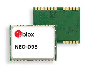
U-blox said its new NEO-D9S GNSS correction data receiver module provides an affordable approach to bringing centimeter-level accuracy to GNSS receivers.
The NEO-D9S receives from correction service providers broadcast on the L-band (1525-1559 MHz). A host processor can then decrypt this correction data and provide it to a high-precision GNSS receiver, combining corrections directly with readings from the satellite constellations to enable much more accurate position readings than those offered by GNSS signals alone.
Use of the NEO-D9S will also increase the availability of high-precision GNSS positioning data in areas with limited connectivity and reduce the amount of cellular data consumed by positioning receivers.
Customers are expected to include carmakers, both Tier 1 and OEMs, industrial system integrators that offer position-correction services, and any other applications that rely on very accurate positioning at low cost.
The NEO-D9S module is a correction-only receiver, based on the latest u-blox ninth-generation (D9) platform. This means that it will integrate easily with the u-blox F9 RTK GNSS receivers from u-blox, or can be used as part of a modular product roadmap. The module also integrates a TCXO and SAW filter to ensure good RF sensitivity and resilience to interference from adjacent channels.
The module includes the algorithms necessary to decode satellite data broadcasts. It is configured to work initially with whichever correction service has been set as default, but can be configured for any L-band data broadcast. It stores its configuration settings in non-volatile memory.
Trimble has acquired Cansel Survey Equipment’s Can-Net and AllTerra New Zealand’s iBase networks. The acquisitions significantly increase the global footprint of Trimble-owned Virtual Reference Station (VRS) networks by adding key geographies in North America and New Zealand.
Subscription-based VRS correction services are now accessible to more customers around the world who rely on high-accuracy corrections to increase productivity and reduce operational costs. The correction services are designed for professionals in agriculture, geospatial and construction as well as emerging high-accuracy applications, such as on-road positioning for passenger vehicles. Financial terms were not disclosed.
The Can-Net and iBase acquisitions add over 1.1 million square kilometers (over 425,000 square miles) to Trimble’s correction services coverage that has grown robustly over the past eight years, contributing to Trimble’s shift toward software, services and subscription business emphasis.
Can-Net Network. The Can-Net network comprises multiple VRS networks and single-base solutions offering GNSS corrections across Canada. The acquisition provides Trimble with the largest VRS footprint in Canada, covering more than one million square kilometers (386,000 square miles).
Subscribers primarily work in the agriculture, survey and construction industries. In addition, the Can-Net network enables Trimble corrections technology to be used by automotive stakeholders deploying ADAS systems along the Trans-Canadian Highway.
iBase Network. The iBase network expands Trimble’s VRS footprint across both the north and south islands of New Zealand, totaling more than 100,000 square kilometers (39,000 square miles).
“The high-accuracy precision provided by VRS technology is a powerful tool in driving operational and financial efficiency for industries that require easy access to positioning services,” said Patricia Boothe, vice president of Trimble’s Advanced Positioning Division. “We are aggressively expanding the accessibility of VRS corrections around the globe. Our vision is to make high-accuracy positioning available to the broadest base of commercial users worldwide for applications in agriculture, construction, automotive, autonomy and others where precise positioning is a critical part of the solution. Trimble will continue to invest in technology and infrastructure to push the boundaries of performance and accessibility for our portfolio of services.”
Trimble networks are supported by a global network operations team made up of GNSS system engineers, geodesy experts and IT professionals. The team monitors the networks 24/7 from operation centers located on three continents, ensuring consistent and reliable service uptime and performance integrity.
NovAtel, part of Hexagon’s Positioning Intelligence division, now brings users greatly improved processing speed and accuracy as well as significantly reduced signal acquisition time through the latest 7.07.03 firmware release.
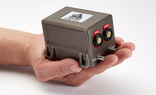
The SPAN CPT7. (Photo: NovAtel)
The firmware works best with the recently launched TerraStar-X correction service, which delivers accuracy and reliability, as well as the OEM7, SPAN CPT7 and PwrPak7 products, which use signals from all GNSS constellations and frequencies to provide users with reliable autonomy and exceptional positioning availability.
The 7.07.03 firmware offers a significant improvement to the SPAN GNSS + INS (inertial navigation system) technology. SPAN with 7.07.03 shows improvements of up to 20% in the horizontal position over the entire SPAN IMU catalog and across various industry use cases including agriculture and marine. SPAN with 7.07.03 also provides improved motion detection, resulting in more robust time to convergence.
“The 7.07.03 firmware features improvements to both our SPAN Marine and SPAN Rail profiles that will greatly impact application performance and consistency,” noted NovAtel Director of Product Management, Neil Gerein, “The SPAN Marine Profile sees improvements to the heave performance and will allow users to start their work significantly faster thanks to a simplified setup for applications in marine dynamics. The SPAN Rail Profile improves position accuracy over long GNSS outages, which is crucial for applications in rail environments that often deal with potential signal obstructions such as trees, tunnels and dense urban areas.”
To download the 7.07.03 firmware update for your platform, click here.