As a valued member of GPS World‘s family, we’d like to share with you a short update. COVID-19 is impacting all of us — individuals, businesses and communities — in unprecedented ways. GPS World continues to be here for you, and while working remotely, will deliver the same information resources across our print and web-based platforms. Consider bookmarking GPSWorld.com and GPSWorld.com/gps-world-coverage-of-COVID-19 or subscribe to GPS World‘s free resources, if you aren’t already receiving them.
Along with delivering the most relevant information GPS/GNSS professionals need to run their businesses, we will continue to share ideas and information to keep our industry moving forward. This moment in history affords us the opportunity to look at new ways to operate and stay connected with each other. With that said, we always welcome your inquiries, insights and ideas, so please reach out. We’d love to hear from you.
Sincerely, Marty Whitford Publisher & Editorial Director
UPDATE: Israel’s High Court of Justice put a stop to the tracking on Thursday, March 19. The court declared that the Shin Bet security service may not track confirmed and suspected coronavirus patients if a Knesset panel to oversee this practice isn’t set up by noon Tuesday, according to Israel news agency Haaretz.
Israel’s internal security agency Shin Bet is using citizens’ smartphones to track the locations of people infected with the novel coronavirus (COVID-19) as well as anyone they might have had contact with, news agencies are reporting. Some citizens report receiving smartphone alerts when they have been near an infected person.
Privacy concerns. The tracking doesn’t require a court order and records will be kept until the regulations expire, according to Israeli news source Haaretz. The regulation can be renewed, and the country’s Health Ministry can keep the location records for 60 days after the regulation expires.
Israeli Prime Minister Benjamin Netanyahu told The New York Times that the government would approve the plan Monay night. “We have to maintain the balance between the rights of the individual and needs of general society, and we are doing that,” he told the newspaper.
No legislature involved. The plan was reportedly approved by cabinet members without approval of the Knesset, the Israeli legislature, which has just been sworn into office and has not yet convened.
Genasys Inc., a global provider of critical communications solutions, has released an interactive map layer service for daily monitoring of Coronavirus – COVID-19 cases.
The company-created Web Map Service (WMS) displays daily spatial data from Johns Hopkins University. The data from reporting countries, which includes U.S. states and territories, tracks confirmed cases and other information.
“As a global provider of critical communications solutions, Genasys is strongly committed to providing information to help keep people safe during emergencies and crisis situations,” said Richard Danforth, chief executive officer, Genasys. “We are providing free use of our WMS feature to keep people informed and assist businesses with decisions regarding employee safety. Additional Genasys COVID-19 response initiatives are planned.”
Follow this link for more information and access to the interactive Genasys WMS: genasys.com/corona/
The unified Genasys Public Safety Mass Notification Platform provides a multi-channel approach to deliver geo-targeted alerts, notifications, instructions and information before, during and after public safety threats and critical business events. The Company’s end-to-end critical communications solution includes SMS, cell broadcast, email, social media and other mobile device emergency messaging.
Genasys systems are in service in 72 countries around the world in diverse applications, including public safety, national emergency warning systems, mass notification, defense, law enforcement and critical infrastructure protection.
GEO Business 2020 organizer Diversified Communications U.K. has decided to change both the venue and date for the event. The event will now be taking place Sept. 24-25 at ExCeL London.
According to show organizers, GEO Business is the U.K.’s largest geospatial event designed for those involved in the gathering, storing, processing and delivering of geospatial information.
“GEO Business is one of the most important business events for the geospatial industry,” said Carsten Holm, managing director of Diversified Communications U.K. “A lot of companies rely on it to meet new and current customers, so this decision has not been taken lightly. However, the response to the outbreak is unprecedented and I think many would agree that it is not a climate in which we want to hold the show. The success, as well as the safety of our exhibitors and visitors, have always been our priority and this continues to be the case. We have been overwhelmed with support on the decision to move the show to new dates, including from our show partners AGI, CICES, TSA, ICE and RICS.”
Portfolio Director Caroline Hobden also addressed the location change.
“After six successful years at the Business Design Centre, we have taken the decision to move GEO Business to the new venue ExCeL London,” she said. “As the show has continued to grow, we have been looking to move to an alternative venue in 2021. However, the current situation presented an opportunity to make the move ahead of plan this year. Best of all, this new tenancy keeps the show in the heart of London.”
A team of medical research and bioethics experts at Oxford University is supporting several European governments to explore the feasibility of a coronavirus (COVID-19) mobile app for instant contact tracing.
According to Oxford, the team has provided European governments, including the U.K., with evidence to support the feasibility of developing a contact tracing mobile app that is instant, could be widely deployed and should be implemented with appropriate ethical considerations.
“Coronavirus is unlike previous epidemics and requires multiple inter-dependent containment strategies,” said Professor Christophe Fraser from Oxford University’s Big Data Institute, Nuffield Department of Medicine. “Our analysis suggests that almost half of coronavirus transmissions occur in the very early phase of infection, before symptoms appear, so we need a fast and effective mobile app for alerting people who have been exposed. Our mathematical modeling suggests that traditional public health contact tracing methods are too slow to keep up with this virus.”
Fraser’s team at Oxford University’s Big Data Institute are continuing to simulate performance of the application so it can be adjusted to include mobile app guided coronavirus testing, and/or provide targeted responses in areas with particularly high rates of transmission, the university said.
“Current strategies are not working fast enough to intercept transmission of coronavirus,” Fraser said. “To effectively tackle this pandemic, we need to harness 21st century technology. Our research makes the case for a mobile application that accelerates our ability to trace infected people and provides vital information that keeps communities safe from this pandemic.”
The AUVSI Xponential trade show has been postponed due to COVID-19, with a tentative reschedule date planned for August.
AUVSI Xponential 2020 was scheduled be held at the Boston Convention and Exhibition Center May 4-7. AUVSI has identified Aug. 9-12 as tentative dates to reschedule the event.
AUVSI Xponential is a large event for the unmanned aerial vehicle (UAV) and unmanned, autonomous industries. Held for the past 47 years, the conference attracts more than 8,500 attendees and 700 exhibitors from around the world.
“Based on currently available information, and with the best interests of our members, exhibitors, attendees and the global community in mind, the AUVSI Board of Directors has made the difficult but necessary decision to postpone AUVSI Xponential 2020,” said Brian Wynne, president and CEO of AUVSI.
Plans to conduct Xponential 2020 in August may change given how rapidly the COVID-19 situation is evolving. In the meantime, AUVSI will provide updates as information becomes available.
“We will continue to actively assess all potential opportunities to best serve the needs of our community while delivering the world-class event you have come to expect from AUVSI,” Wynne said.
AUVSI has created an email address, [email protected], for submitting inquiries about the plans to reschedule Xponential 2020. The association’s staff will respond to questions and concerns about the conference as quickly as possible.
“We appreciate the incredible support, cooperation and patience we have received from the unmanned systems community as we work through this evolving global issue,” Wynne said.
The IEEE/ION PLANS Conference has been canceled. The conference — officially the IEEE/ION Position Location and Navigation Symposium (PLANS) — was scheduled to take place April 20-23 in Portland, Oregon.
“After careful consideration, the ION Executive Committee, in cooperation with the IEEE/ION PLANS program committee, made the decision this afternoon to cancel,” said ION Executive Director Lisa Beaty in an email sent March 12.
The Institute of Navigation’s (ION’s) official position has been posted here.
The ION National Office has notified PLANS authors, exhibitors and vendors and provided each with additional information pertaining to their particular relationship or circumstance.
“The ION Executive Committee will be discussing additional follow-up considerations later this month,” Beaty said.
The Center for Systems Science and Engineering at Johns Hopkins University is tracking the coronavirus, COVID-19, via an Esri ArcGIS map.
The map is updated in almost real time, and it includes a zoomable map identifying confirmed cases of the virus throughout the world. It also includes numerical data on how many cases have been confirmed in each country, as well as deaths and recoveries.
“In response to this ongoing public health emergency, we developed an interactive web-based dashboard hosted by the Center for Systems Science and Engineering at Johns Hopkins University, to visualize and track reported cases in real-time,” John Hopkins stated on its website. “The dashboard, first shared publicly on Jan. 22, illustrates the location and number of confirmed COVID-19 cases, deaths and recoveries for all affected countries. It was developed to provide researchers, public health authorities and the general public with a user-friendly tool to track the outbreak as it unfolds.”
Men wearing white bio-suits entered the market from the main entrance. A panic ensued at the sight, and a commotion quickly spread through the crowd.
Shop keepers, sensing the worst, hurriedly gathered their belongings. People rushed towards the exits. More armed soldiers in white bio-suits pressed in, sealing off escape. Screams and weeping filled the market with the din of anxiety and fear. The Huanan Seafood Market was under lock down. The order was not to hurt anyone, but no one was to leave. The quarantine had begun.
Empty semi-trucks lined the main road. The trucks entered the parking lot one by one, and masked soldiers guided people into the backs of the empty trucks. Once filled, the trucks drove away until the market was empty. The people were transported to “isolation centers” several hundred kilometers outside the city.
Image: Duncan A Smith, CASA UCL. Data from Global Human Settlement Layer, https://ghsl.jrc.ec.europa.eu/index.php
In Wuhan, the situation had deteriorated rapidly. A month earlier videos went viral about a mysterious flu with pneumonia-like symptoms. Most of the information was coming from citizen journalists. People speculated the Huanan Seafood Market was the source of the illness, but no official statements had been made.
Anxiety spread. People began fleeing Wuhan ahead of the Chinese New Year, which is the world’s largest annual human migration. Making matters worse, Wuhan is a major transportation hub in Central China, servicing 400,000 commuters per day through the Hankou Railway Station, a short, 15-minute walk to the Huanan Seafood Market.
Alerting the world
On Dec. 31, 2019, China notified the World Health Organization (WHO) of the infection. The cause was a new strain of coronavirus along the same viral spectrum as the severe acute respiratory syndrome (SARS) and the Middle East respiratory syndrome (MERS). The next morning, on Wednesday, Jan. 1, 2020, the WHO declared the novel coronavirus 2019 (COVID-19) a public health emergency. It was also that morning that the seafood market was shutdown.
Above: One of the first and only videos coming out of China that covers the outbreak. Copyright: DW News, posted 23-JAN-2020
Twenty-three days after China notified the WHO, the city of Wuhan and the entire province of Hubei were quarantined and cut off from the rest of the world — an area comprising 57 million people, unprecedented in the history of public health.
Still, even with such extraordinary measures, it was already too late. The people moved faster than the system could adjust. Five million people, almost half the residents of Wuhan, had already evacuated. Many traveled to other parts of China to stay with family while others left China altogether, some finding themselves in countries they were banned from entering.
Containment and quarantine
China is now dealing with a containment issue at some level in every one of its provinces. In total, 174 million people in China are under some level of travel restriction. By comparison, that is equal to more than half the population of the United States.
China immediately began leaning on its massive surveillance network and facial recognition technologies to control the outbreak. Using these technologies, Chinese authorities could narrow the search for those most likely to carry the virus. The situation transitioned from a medical emergency to a national security emergency on Tuesday, Feb. 11, when China fired its two highest ranking medical officials in Hubei province, replacing them with a senior Chinese government party official.
Additionally, China continues working with the three cellular phone carriers in the country to gain access to users’ location data. This information will enable China to conduct geospatial analysis at an individual scale to identify those who have come into contact with infected areas. This practice is very controversial, placing privacy and human rights in conflict with public health security.
Roots of GIS in epidemiology
Epidemiology is the study of people, place and disease, perfectly suited for geospatial technologies. Not surprisingly then, the true origins of geographic information systems (GIS) are founded in epidemiology, harkening back to John Snow’s Cholera map in 1854. The location of infected people clearly pointed to the Broad Street water pump as the cause. That changed the scientific understanding of the time from believing cholera was transmitted in the air to realizing it was a waterborne disease.
John Snow’s 1854 map of the London Broad Street Cholera outbreak. (Image: public domain)
Similarly, the scientific consensus of COVID-19 has also changed since it first emerged. When the outbreak began, it was believed to be zoonotic, meaning the virus originated from animals and transmitted to humans. It was then believed the virus could only be transmitted directly from person to person. Now, it is known to be carried through the air or by touching infected surfaces.
Each of these modes changes the transmission rate of the disease. This is known as the reproduction number, written as R0 and referred to as the R-naught number. The larger the R-naught, the more infectious the disease. COVID-19 is estimated to have an R-naught between 1.4 and 6.6, which is similar to its cousin the SARS virus; however, SARS only infected 8,096 people and this virus is already more than 10 times that amount.
In terms of GIS, the higher the R0, the greater the geographic area potentially infected. Narrowing the area to concentrate resources more efficiently requires improved modeling and collecting more data, both of which increase the time required before effective measures can be taken. This creates a dilemma between acting swiftly and acting accurately. This explains some of the images coming out of China showing people forcibly removed from their homes and placed in quarantine.
Image: John Hopkins CSSE, https://systems.jhu.edu/research/public-health/ncov/
Controlling the spread of the virus also requires knowing the source of each outbreak. The originating source, called the reservoir, once discovered can be cordoned off. Afterwards, through a process called “contact tracing,” all potentially infected people are tracked down and monitored or quarantined if necessary.
Probability models based on geospatial analysis use factors such as age, sex, pre-existing health conditions and distance from the reservoir overlaid with data such as population density to create an intensity map showing the areas most favorable to the spread of infection. People in the defined areas can be isolated and monitored, preempting further spread.
Click to enlarge. (Maps: Centers for Disease Control and Prevention)
In the United States, the Health Insurance Portability and Accountability Act (HIPPA) requires data be aggregated at the zip code or county level, which is useful in defining regional trends, such as the CDC maps above of heart disease (red) and the areas of least physical activity (teal). Comparing the two visualizes the premise that exercise and good health go together. However, at this scale the information is not useful in fighting a dynamic and evolving situation like an infectious outbreak.
Ultimately, the goal is real-time feedback at a high-scale resolution. Smartphones and other mobile devices offer unique opportunities to combat epidemics. South Korea is using location information to help contain the outbreak. People use a special number to text where they have traveled. This is to assist in contact tracing if necessary.
Mobile devices can also report location data along with vital signs to monitor overall health and instantly identify individuals who may be a risk. The mobile device can also alert individuals if they are nearing an infected area and show the infected zones on their phones.
COVID-19 reporting via GIS
Systems can be established to report live events like Waze does for reporting traffic hazards, which have proven to report accidents faster than 911 calls. Also, the use of social media live feeds can help identify evolving situations and monitor existing ones.
Perhaps the government, working with mobile application mapping companies, should create a layer specifically for the epidemic that provides critical information, such as healthcare centers, some of which might be established specifically for the care of the disease outbreak.
Also, included in that public health layer would be high-risk areas, prohibited entry locations, areas under quarantine, and more, in order to provide an integrated interface to communicate with the general public. This is similar to how the departments of transportation, public works, and emergency response units provide information to the public to reroute traffic around congestion, accidents or closed-off areas.
Image: Coronavirus story map by Maria Laturnas, University of Potomac
A former U.S. Navy healthcare executive, Ben Boccuzzi, Ph.D., shared his thoughts on the matter with me. “The actual mortality rate of COVID-19 (in the U.S.) is hard to determine until mass testing can be done,” Boccuzzi said. “As of now, the true denominator (all people that would test positive for the virus) we only know of symptomatically and those that died from the disease. So, with these small numbers, the real mortality rate is not fully known. When testing begins on a grander scale, and more people are known to have the virus and do well, the actual rate of mortality will become much smaller.”
It is now more than two full months since the WHO declared a public health emergency. The number of known cases worldwide stands at 105,941 with 3,569 deaths affecting 100 countries.
Image: Coronavirus story map by Gangesh Khadka, University of Potomac
If you have read this far, thank you. I would like to leave you with the most important information in this article.
When I began covering this story it was early January, the virus was just beginning to make the news. Fear was in the air. I began to worry. As I immersed myself deeper into the topic, I became even more concerned; so much so, I bought two months of supplies preparing for a long-term self-quarantine situation.
If you’ve been watching the news, you may be nearing the same state of mind I found myself in. If so, I’ve got good news for you.
Paradoxically, people are attracted to fear. Fear is a potent biochemical rush. The horror movie industry rakes in $11.7 billion per year. Most media’s primary business is not information. It is using information to increase its readers and viewers, and fear captures people and holds their attention. The media is a profit-driven business. Facts tell. Fear sells.
The following is what is reported by the WHO based on 55,924 laboratory-confirmed cases since the coronavirus began. The study was published on Feb. 28. At that time, there were 86,992 confirmed cases of COVID-19 and 2,979 deaths, equating to a mortality rate of 3.4%, but those numbers were mostly in China, specifically Hubei province. Outside of China, the number of cases were only 7,166 with 109 deaths having a fatality rate of 1.5%.
Image: Coronavirus story map by Zaid Alshaboul & Kush Shah, University of Potomac
These numbers do not reflect the whole story. If you are below age 50 and in good health, recovery is 99.1%, so there is almost no reason to be concerned. For those older than age 50 the mortality rate is 1.3%, and over age 60 it increases to 3.6%. For those over age 70 it doubles to 8.0%. The most vulnerable populations are those over age 80 with a mortality rate of 14.8%.
Additionally, those with pre-existing conditions, such as cardiovascular disease, diabetes, or respiratory disease are also at high risk. If you fall into either of those categories, take great care with your hygiene and personal protection. However, if you are below 60 and in moderately good health, there is less than a 1.3% reason to be concerned and more than 98.7% reason not to be concerned.
Unless something significant changes, the virus is a reason for caution, but should not be a cause for panic. The fearmongering has gotten out of control. We may or may not get COVID-19, but for those of us who do, most of us will only experience muscle aches, fever and a dry cough, about the same as catching a bad cold.
Ironically, be grateful in times like these. They give us reasons to take pause, love our family, appreciate what we have, realize life is worth living, and get our house in order. The truth is not the story we are being sold.
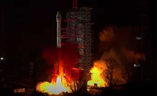
China successfully launched the penultimate Beidou navigation satellite on March 9. An official Xinhuanet news release has not yet been issued, but CGTN — a television station partially funded by the Chinese government — posted a video of the launch.
China launched the new satellite from the Xichang Satellite Launch Center in southwest China’s Sichuan Province at 19:55 Monday (Beijing Time), paving the way for its completion and full global coverage in May.
The Long March 3B/E rocket lifted off from Xichang Satellite Launch Center at 7:55 a.m. ET. The Beidou GEO-2 satellite was sent into a geosynchronous transfer orbit.
Coronavirus Fight
China has touted the BeiDou constellation’s role in helping the country fight the novel coronavirus (COVID-19) epidemic with high precision from space.
“When China was building the two makeshift hospitals — Huoshenshan (Fire God Mountain) and Leishenshan (Thunder God Mountain) in Wuhan, the epicenter of the epidemic — equipment based on the BeiDou Navigation Satellite System (BDS) provided high-precision positioning service and accelerated the construction,” stated a press release from the China Aerospace Science and Technology Corp. (CASC).
Drones based on the BDS have been utilized to spray disinfectant, according to the press release. Police in Ruichang, east China’s Jiangxi Province, used BDS-based drones to patrol crowded places to prevent intensive contact between people.
China’s Ministry of Transport sent epidemic prevention and transportation service information to more than 6 million vehicles via the BDS terminals, and provided services for the transportation of emergency materials to the areas most affected by the epidemic.
China Post Group Co. Ltd. has installed 5,000 BDS terminals on its trunk line vehicles, and used the vehicle positioning information to conduct real-time supervision and allocation, so as to ensure timely delivery of epidemic prevention materials.
In Wuhan, the BDS-based robots of the e-commerce and logistics company JD.com delivered medical materials to hospital isolation areas with high speed.
China began to construct its navigation system, named after the Chinese term for the Big Dipper constellation, in the 1990s and started serving the Asia-Pacific Region in 2012.
Over the past two years, China has successfully sent 28 BDS-3 satellites and two BDS-2 satellites into orbit.
With the system’s upgraded intelligent operation and maintenance capabilities, the BDS-3 has provided stable and accurate services, boasting a positioning accuracy of better than five meters.
China plans to launch more BDS satellites in March and May to complete the global network.
Organizers stated, “In light of the current situation caused by the coronavirus as well as related travel restrictions and resulting cancellations we unfortunately are forced to cancel the Munich Satellite Navigation Summit 2020 as we are no longer able to provide a well-ordered and appropriate program.”
Those who were attending are asked to be patient as the event organizers proceed to “sort out all necessary administrative issues.”
The summit brings together experts in industry and government; this year, it was go take place in Alte Kongresshalle, Munich, Germany.
Attendees are also told it may be possible to transfer their registration to the 2021 conference.
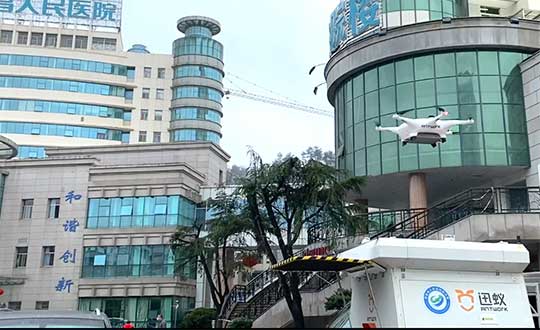
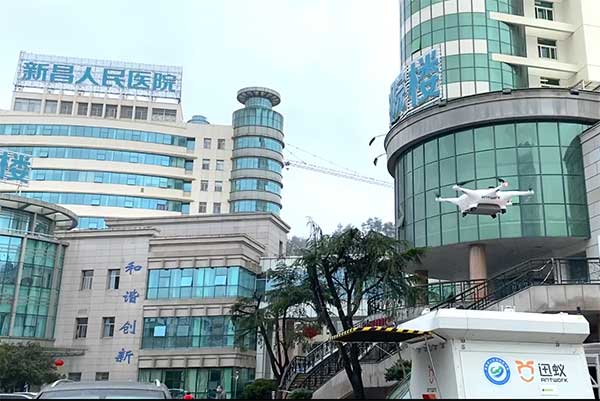
Through its group company Antwork, Japanese company Terra Drone is employing its UAV system to transport medical samples and quarantine supplies in China to fight the coronavirus.
At 9 a.m. on Feb. 6, a medical delivery drone flew from the People’s Hospital of Xinchang County to the disease control center of Xinchang County, marking the launch of the first urban-air transportation channel to help to fight the novel coronavirus (COVID-19 ), a global health emergency.
Take off and landing point of Xinchang people’s Hospital. (Photo: Terra Drone)
The World Health Organization reports at least 95,270 people are infected and at least 3,280 have died. China, where COVID-19 originated, is in a tense period of epidemic prevention and control. Xinchang County is in Zhejiang province — one of the areas most severely hit by the virus.
As soon as the Wuhan quarantine began on Jan. 23, Antwork petitioned to provide drone technical support.
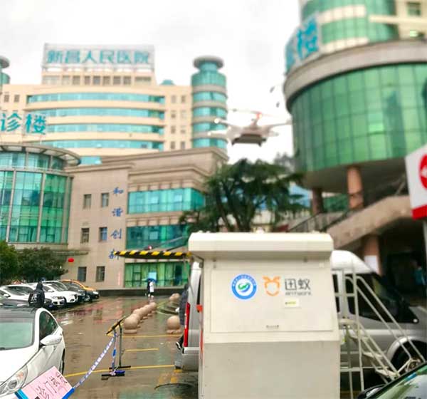
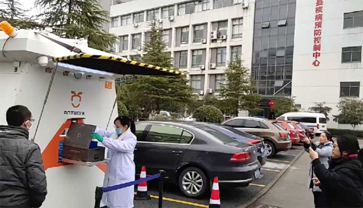
Antwork’s RA3 and tr7s drones and unmanned RH1 station are ensuring that medical samples and quarantine materials can travel with minimal risk between Xinchang County People’s Hospital and Xinchang County’s disease control center. The automatic, unmanned air delivery system significantly reduces contact between samples and personnel, as well as improves delivery speed.
Antwork branch company Aerodeli, which undertook the operation, obtained the first urban drone delivery license issued by the Civil Aviation Administration of China (CAAC) in October 2019. The sample delivery work is carried out in strict accordance with certified operation procedures to ensure the safety of medical samples during transportation.
Take off and landing point of disease control center of Xinchang County. (Photo: Terra Drone)
Using drones has increased the speed of transport by more than 50% compared to road transportation, proving to be a more efficient means of transportation for epidemic prevention and control. The drones also relieve the personnel shortage as more and more medical staff and ambulances are transferred to the front lines — making the best use of human and material resources.
After the project for Xinchang People’s Hospital was put into operation, Antwork began assisting more medical institutions in China to deploy drone transport services for the anti-epidemic effort.
A drone departs from the disease control center of Xinchang County. (Photo: Terra Drone)