Modernized communications lines were installed at seven locations worldwide in an overhaul of the global communications network that provides command and control of the GPS constellation.
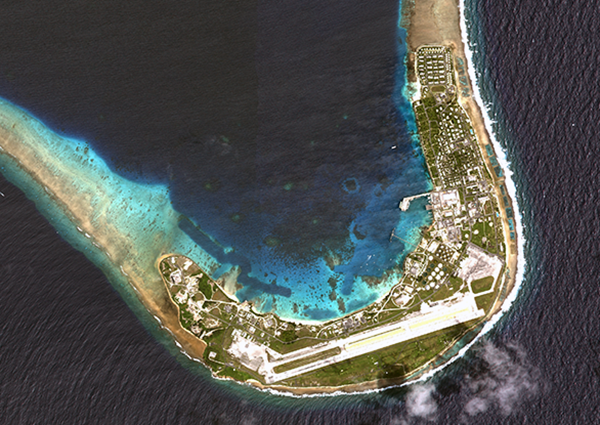
Kwajalein Atoll in the Marshall Islands is one of seven locations that received a GPS communications network overhaul.(Photo: USGS)
From 2018 to 2022, GPS Product Support Delta — in conjunction with the Defense Information Systems Agency (DISA) — performed a complete overhaul of the global communications network required to provide command and control of the GPS satellite constellation. GPS Product Support Delta is under Space Systems Command of the U.S. Space Force.
The project, called GPS Operations Network Enhancements (GONE), connected multi-protocol label switching internet protocol (IP)-based routers to modernized communications lines at seven key GPS facilities, replacing older serial lines.
“With the GONE project completed, we are seeing a 75 percent reduction in communication line interruptions.”
The GONE initiative “has significantly enhanced communications for GPS weapon systems,” said Brian Botka, Product Support Delta GPS program manager.
“These upgrades not only increase communications speed and reduce overall down-time and adding a new paradigm in network resiliency with the networks capable of recovering in mere seconds from an outage or issue,” said Sean Foley, DISA technical project manager. “The system upgrades will continue to improve service to the warfighter as well as enable increased resiliency and network diversity for DISA.”
The modernized communications lines were installed at
Schriever Space Force Base, Colorado
Vandenberg SFB, California
Cape Canaveral Space Force Station, Florida
Facilities in Hawaii, Ascension Island, Diego Garcia and Kwajalein Atoll.
Throughout the COVID-19 pandemic, many of these locations were under strict lockdown or required long quarantine periods, making coordination and travel to remote locations more challenging.
Lockheed Martin was the contractor who supported Product Support Delta GPS on the GONE project. “This was a collaborative effort with Product Support Delta GPS and DISA that required significant logistical efforts due to the COVID-19 pandemic,” said Christina Mancinelli, Lockheed Martin GPS Ground Programs director.
“With the GONE project completed, we are seeing a 75 percent reduction in communication line interruptions, and we expect that metric to continue to improve,” Mancinelli said. “The migration of the GPS communication lines to the modern MPLS [multiprotocol label switching] routers and Ethernet-based connections continues the significant improvements in GPS ground capability, cybersecurity and reliability.”
SSC is the USSF field command responsible for rapidly identifying, prototyping, and fielding resilient space capabilities for joint warfighters. It delivers sustainable joint space warfighting capabilities to defend the nation and its allies while disrupting adversaries in the contested space domain.
SSC mission areas include launch acquisition and operations; space domain awareness; positioning, navigation, and timing; missile warning; satellite communication; and cross-mission ground, command and control and data.
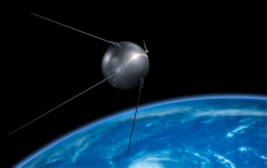
The world watched in awe and a bit of terror as the 23-inch polished metal sphere arced across the sky. Its elliptical, 65-degree declination low-Earth orbit covered virtually the entire planet. Its beep, beep, beeping could be easily heard by professional and armature radio operators alike.
The Soviet Union had just put the world’s first artificial satellite, Sputnik I, in space. It was Friday, the 4th of October, 1957.
The Soviets had gained the high ground, quite literally. The Space Race had begun. As had the West’s greatly increased focus on education in science and engineering. School children in the United States would never lack for homework again.
On Monday, the 7th of October, scientists William Guier and George Weiffenbach arrived to work at the Johns Hopkins University Applied Physics Laboratory in Laurel, Maryland. To their surprise, they found no one had been listening in on Sputnik’s signal over the weekend. So, they decided to do just that. Just for good measure, they also recorded it.
Thus began a series of events that led directly to every satellite navigation system that has come since.
Guier and Weiffenbach’s story was documented in the Johns Hopkins Technical Digest in 1997. It is a fascinating tale of discovery. I highly recommend it.
And it may be a good reason for October 7 to become “World SatNav Day.”
The Drone Tournament has relaunched following the COVID pandemic, and will take place June 8-10 in Helsinki, Finland.
In the competition, drones will compete to prove precision-control drones over land and sea. GNSS companies Septentrio, Spirent and u-blox will take part.
Sponsored by Ultrahack, the competition seeks to boost use of drone technology, including for 5G networks and satellites. The challenges are especially related to landing and precision flight in demanding and changing environments. Contestant drones will use a wide spectrum of navigation and sensor technology, including GNSS.
U-blox, Spirent and Septentrio are offering their GNSS technology for the participants.
Septentrio and u-blox will provide GNSS services that teams can use to increase performance as they land their drones on a moving boat. To help improve performance, Septentrio and u-blox will provide access to data streams from a base station on the shore and on the boat.
The streams will provide raw observations in RTCM3 format via NTRIP (which can be used to compute a real-time kinematic, or RTK, position of the drone). The stream from the boat will also provide position, heading and speed of the boat over an IP connection in NMEA or binary format.
Using these streams can help to obtain an RTK solution on the drone or to know the relative position between the drone and the boat.
The winners will receive monetary prizes and the possibility of negotiating commercial agreements for further development of their solutions.
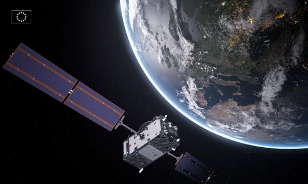
After a challenging Launch and Early Orbit Phase (LEOP) and testing campaign during the COVID-19 pandemic, Galileo satellite “Nikolina” (GSAT0223) entered service on May 5. The satellite will reinforce the performance and robustness of the Galileo satellite.
GSAT0223 was launched Dec. 5, 2021 with Galileo launch L11 after the usual design, acceptance, validation, launch and early orbit preparation and operations phases.
This was the first Early Orbit Operations phase conducted directly from the operational center in Germany, under the responsibility of EUSPA.
GSAT0223 and its launch companion GSAT0224 (Shriya) are the first pair of the third batch of Galileo First Generation satellites to reach space. GSAT0223 will fill the last empty slot in Galileo’s orbital plane B.
Shriya will soon complete its in-orbit validation and will then join the operational constellation. Ten additional satellites of the same batch are continuing assembly, acceptance and launch preparations.
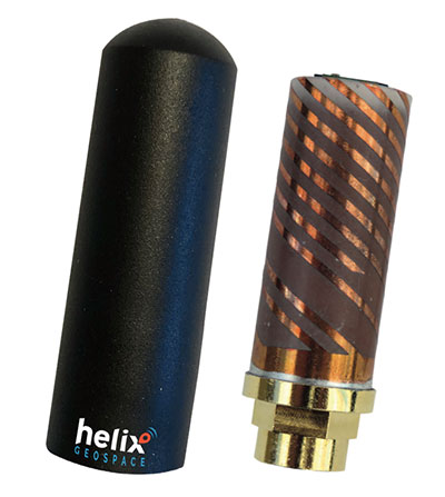
Helix builds precision GNSS antennas that enable product designers to create small, accurate positioning, navigation and timing (PNT) synchronization products that defend against vulnerabilities and threats. Helix is also developing its antennas to provide navigation for autonomous vehicles.
Helix’s patented DielectriX antennas are targeted initially to receive PNT signals from GNSS (GPS, Galileo, GLONASS, Beidou) constellations, and the Satelles STL (Satellite Time and Location) signals delivered over the Iridium constellation as well as Iridium’s voice and data network.
Future antenna variants will support low-Earth orbit (LEO) PNT services being planned and built by private companies, as well as government agencies, the company said.
DielectriX antennas discriminate true satellite signals from multipath signals, interference and jamming, delivering high performance in a compact and rugged form factor. Helix’s customers include defense, automotive, aerospace and critical infrastructure companies.
Helix previously raised £2.5 million from UKI2S and angel investors, and has participated in Wayra UK’s Intelligent Mobility Accelerator programme and Seraphim Capital’s Space Camp Mission 6. Helix also received additional grant funding for advanced antenna development from the European Space Agency, and for anti-jamming/spoofing technology from UKI2S.
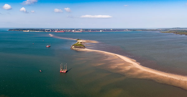
Fugro has completed a geotechnical site characterization project for DRA Global as part of the proposed expansion of the port of Richards Bay in South Africa.
Fugro’s self-elevating platforms being positioned in Richards Bay ready for their geotechnical site characterization for the planned port expansion. (Photo: Fugro)
DRA Global contracted Fugro to acquire critical seabed geodata required for the completion of preliminary engineering and design works. The project began with a cross-continental mobilization of marine assets from Bangladesh and UAE to Richards Bay and was safely delivered despite challenging ground conditions and ongoing COVID-19 restrictions.
The very soft soils encountered at depths of more than 40 meters below the seafloor required an innovative solution for positioning the two geotechnical drill rigs safely, so Fugro mobilized two bespoke modular self-elevating platforms (SEPs) to acquire high-quality geodata in a wide range of water depths. Their experienced staff, combined with adaptable marine assets and tooling, enabled Fugro to deliver DRA Global’s requirements in full and avoid any data gaps that could have led to an over-engineered design and ultimately higher construction costs.
“Fugro performed well under difficult circumstances, including challenging site conditions and intense focus on environmental management in sensitive areas, all while working in an operational port,” said Cobus Rossouw, principal marine engineer at DRA Global. “Their robust safety management systems resulted in an investigation completed without a single lost-time incident.”
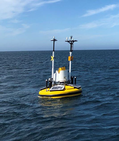
Energinet contract for wind lidar measurements
Fugro’s Seawatch lidar buoys will record continuous wind measurements to support wind-resource mapping for Denmark’s Energy Island development. (Photo: Fugro)
Fugro has secured a contract with Energinet to provide floating wind lidar measurements for what an offshore artificial energy island, which is being constructed for the Danish Government.
Fugro will install and operate four SEAWATCH wind lidar buoys at two locations, Energioe Nordsoen and Energioe Baltic, that will act as hubs connecting several offshore wind farms.
Starting this month October, the buoys will record continuous wind measurements for a minimum of one year to support wind-resource mapping for the two islands, and the engineering and design of the future wind farms. Fugro is already performing geophysical surveys for the Energy Island project under a separate contract to provide Energinet with a reliable de-risked site interpretation.
The SEAWATCH wind lidar buoy can record wind measurements up to 250 meters above sea level, and wave measurements and current profiles down to the seabed. The buoy also acts as a multipurpose platform for additional metocean sensors and, on this project, will be fitted with sensors to capture geodata on environmental impact parameters.
Contract for erosion off Indian coast
OCS Services Pvt. Ltd (OCS), one of India’s marine service providers, has awarded Fugro a two-year contract to support its asset integrity and corrosion management operations off the west coast of India.
Fugro will help OCS deliver on ONGC’s Protective Coating of Process Platform Project 1, an infrastructure project to maintain and refurbish 32 offshore platforms in seven clusters. The project is expected to be completed by May 2023.
Galileo Control Centre in Oberpfaffenhofen, Germany. (Photo: ESA)
News from the European Space Agency (ESA)
The 11th launch of Galileo satellites, planned for Dec. 1, marks an important program milestone. With an upgrade of the Galileo Control Segment (GCS), this will be the first launch where the satellites’ first steps into space will be overseen from the Galileo Control Centre in Oberpfaffenhofen, Germany.
Up until now, the Launch and Early Operations Phase (LEOP) of Galileo satellites has been overseen from an external mission control site — either ESA’s ESOC control centre in Darmstadt, Germany, or French space agency CNES’s site in Toulouse, France.
The demanding upgrade of the GCS to Version 3.0 was performed by an industrial consortium led by GMV in Spain. The control segment encompasses the two Galileo Control Centres in Oberpfaffenhofen in Germany and Fucino in Italy, as well as six Telemetry, Tracking and Control (TT&C) ground stations used to monitor and command the 26 Galileo satellites in orbit.
As well as increasing overall reliability and cybersecurity, the new upgrade opens the way to significant expansion of the Galileo constellation, enabling oversight of up to 38 satellites.
Over the last three years, a complete technological refresh of the GCS software and hardware was done, including porting of software modules corresponding to several million lines of code, the deployment of equipment at many Galileo sites, and the execution of a rigorous level of testing throughout all elements comprising the system.
Commencing in mid-2018, the upgrade had to contend with the worldwide COVID-19 pandemic midway through its lifetime, but the team pushed on to conclude at the end of July. Since Aug. 4, it has been used to nominally operate all the satellites in the constellation.
The project was overseen by ESA in its System Prime role managing Galileo’s design, development, qualification and deployment of future upgrades on behalf of the European Commission, Galileo’s owner.
Roscosmos plans to place GLONASS ground stations in Brazil, China, Indonesia, India and Angola, reports the TASS news agency.
“In the near future, another six non-request measuring stations are to be placed abroad: two in Brazil (Belem and Colorado de Oeste), one in China (Shanghai), one in Indonesia (Bukittinggi, West Sumatra), one in India (Bangalore) and one in Angola (Luanda),” the corporation said.
Negotiations with foreign partners have been held. On-site reconnaissance work has been carried out and contracts are being coordinated.
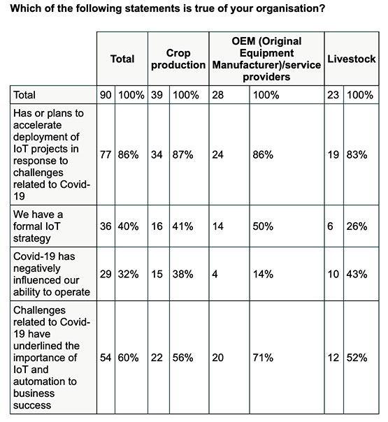
New Inmarsat research reveals a rapid increase in levels of industrial IoT maturity in 2021, with agricultural businesses accelerating IoT adoption in response to COVID-19
Research by Inmarsat, a global mobile satellite communications company, reveals a rapid increase in the maturity level of the industrial internet of things (IoT) across the agricultural sector since the start of the COVID-19 pandemic, with 86% of ag business accelerating or intending to accelerate deployment.
Respondents in the report, “Industrial IoT in the Time of COVID-19,” include crop producers, OEMs, service providers and livestock businesses, who report that COVID-19 demonstrated the importance of IoT to their businesses.
According to the research, adoption has seen huge progress from 2020 to 2021, with automation and cost savings the greatest drivers. Four-fifths (80%) of agricultural respondents have now fully deployed at least one IoT project, with 53% having achieved this in the 12-month period from the second quarter of 2020. Of the remaining 20% of agricultural respondents that have not yet adopted IoT in any form, all of them are either currently trialing it, or plan to deploy or trial at least one IoT project in the next two years.
Chart: Inmarsat
A further 86% of agricultural respondents indicated they have or they intend to accelerate the adoption of IoT in response to challenges related to COVID-19. This figure includes 46% who have already accelerated IoT adoption to respond to COVID-19, versus 29% who will accelerate over the next 12 months and 11% who will accelerate beyond the next 12 months.
The 46% that have already accelerated IoT adoption are less likely to state that COVID-19 has negatively impacted their ability to operate, demonstrating a link between IoT and business continuity during the pandemic. Additionally, more than half (60%) of respondents in the sector indicated that business and operational challenges related to COVID-19 have underlined the importance of IoT.
“We have seen agricultural producers take on more and more solutions that allow them to operate remotely, from autonomous irrigation control to the latest precision farming technologies, demonstrating increased faith in the technology,” said Steven Tompkins, Director of Market Development at Inmarsat.
As part of the research, Inmarsat is offering businesses the opportunity to measure their IoT readiness compared to the respondents in the survey, using their free IoT maturity tool.
“Crime is common. Logic is rare. Therefore, it is upon the logic rather than upon the crime that you should dwell.”
“Data! Data! Data!” He cried impatiently. “I can’t make bricks without clay.”
— Sherlock Holmes, “The Adventure of the Copper Beeches,” Sir Arthur Conan Doyle
Watson is to Holmes what information is to intelligence. Watson could listen to the client story, observe the situation, and recite to Holmes all the relevant facts, but he lacked the ability to string together the seemingly random pieces of information into a coherent chain of events leading to the correct hypothesis. A computer can become a Watson, but it takes a human to be Sherlock; however, a human misguided by cognitive biases will end up as Inspector Lestrade, always coming to the wrong conclusion.
When it comes to data, the analogy of drinking from a fire hose is an understatement. Consider that a digital image can be terabytes in size and every day millions of images are taken. Facebook generates 4 petabytes of data daily, and each day there are 500 million tweets and 306 billion emails. Additionally, there are 20 billion connected devices. Combined, the world creates 2.5 quintillion bytes of data every day. If a grain of sand represents a byte of data, then every three days more data is created than there are grains of sand on the Earth, and it is only increasing.
Somewhere in all that data are signals. Real-time threat intelligence systems are looking for those signals before the next huge event occurs. It is a high-stakes hunt for Leviathan, except that Leviathan is only a packet of sand traveling at lightspeed through a cloud obscured by dust.
Nellis Air Force Base takes part in Red Flag 15-2 at its Combined Operations Center in 2015. (Photo: Senior Airman Thomas Spangler/U.S. Air Force.)
Interpreting a Signal
The massive volume, variety and velocity of continuously flowing data far surpasses the ability of humans to process. It exceeds the bandwidth most systems can handle. And it quickly overwhelms the capacity to store, manage and act on the information in a timely and cost-effective manner. Resources are not infinite. The best model to handle an overwhelming amount of data is the human brain. Humans are biological sensors. Every moment of every second of our lives, our bodies are receiving an endless stream of stimuli from internal and external sources. Most of this stimuli registers at an unconscious level, and as long as the stimuli is normal and expected, it goes unnoticed by the conscious mind. If, however, any discomfort is experienced, the conscious mind is notified. Then that becomes the focus until normalized. Externally, the same applies to computer data systems. Normal conditions are ignored, but if there is something unusual, such as a loud constant noise, or a colder than normal temperature, it draws all the processing attention.
In the realm of intelligence that is basically how things function. Algorithms are written to learn the normal patterns of life and to identify specific events, words, names, etc. As long as data is within normal parameters, it gets little attention, but as soon as an anomaly exceeds a threshold or something triggers the algorithm, it will immediately be brought to the attention of the intel center. An example can be viewed on the Global Incident Map dashboard. I encourage you to sign up for a free 72-hour membership. If you want to see what real news looks like, this would be a sampling. The number of real incidents that happen across the country and around the world that you never hear about, many of them hair-raising and all of them open source, add to the few stories the media has been able to tell about cyber attacks. Scroll down the page. There are many filters, but I recommend turning them all off to see the full extent of information. Clicking on an incident will drill down into the actual source so you can read about it more thoroughly.
Below is the U.S. Army’s real-time critical incident dashboard called the Joint Analytic Real-Time Virtual Information Sharing System (JARVISS). It tracks and monitors activity near U.S. Army installations and standalone assets of interest around the world.
Another dashboard for cyberattacks is Check Point, which shows just how aggressive cyberthreats are throughout world. Here, you can see the patterns of coordinated attacks. A war is underway. The soldiers are cyberwarriors. No country is safe. View the Live Cyber Threat Map.
JARVISS is designed to target criminal activity and provide natural disaster information in and around Army installations and stand-alone facilities, as well as COVID-19 threats. (Image: Steve Gardner/U.S. Army}
Fast Analysis in Real Time
Monitoring this information, analysts look for connections. If a plane veers off its flight path, the local operations center is notified. An automatic query shows if any critical-infrastructure assets or other important structures and facilities are in the area. The analyst can immediately find out the type of aircraft, the call sign, who the plane is registered to and who filed the flight plan. Weather radar can be overlaid to see if that is a possible reason for the deviation. Incident reports can be displayed in real time within the area of interest, along with social media feeds and other sources of communication. Traffic patterns can be displayed.
The important question that needs to be answered is whether this is a potential threat. Is there a connection to anything going on anywhere else? A dossier is developed on the person who filed the flight plan, the one who is assumed to be the pilot and the person or organization to which the plane is registered. All of this is being done in a matter of minutes, while the airplane either returns to its flight path or continues its diversion. The air traffic control tower is contacted to share information on the aircraft and its deviation. If the tower does not have an answer, it will radio the pilot for an answer. The passenger and crew manifest also are analyzed. All the data that can be pulled together — including the remaining fuel burn and the aircraft performance limitations — are analyzed.
Patterns emerge from the data. These patterns lead backwards to a cause and forward toward the end result. Finding those clues in the data requires a team of specialists from six primary intelligence disciplines.
An imagery intelligence analyst brings in the live-streams and remote sensing.
A human intelligence analyst seeks motivating factors and ways to deescalate the situation.
A measurements and signatures intelligence specialist defines the operating limitations and the mechanics and science particular to the scenario.
An open-source intelligence analyst accesses and queries open-source data sets to provide clues.
A signals intelligence specialist focuses on the communications and electronic signatures.
A geospatial intelligence analyst brings it all together and provides spatial context through the map the team uses that shows the events unfold in real time.
These analysts and sometimes many others will collect all these pieces of information and turn them into intelligence that decision-makers can use to take action. That is the purpose of intelligence; as CIA veteran Richard Heuer stated, “Intelligence seeks to illuminate the unknown.”
Fortunately, most alerts turn out to be false positives, but every one of them is treated as if it were “the one.” These false positives turn out to be excellent, real-world exercises that hone the skills of the team and wire the brain for speed. These events can last mere minutes or several hours. It’s an adrenaline rush.
To explore live streaming data feeds, Esri has a growing volume of data in its ArcGIS Living Atlas.
“My mind rebels at stagnation. Give me problems, give me work, give me the most abstruse cryptogram, or the most intricate analysis, and I am in my own proper atmosphere…”
— Sherlock Holmes, “The Sign of the Four,” Sir Arthur Conan Doyle
William Tewelow works for the Federal Aviation Administration. He is a graduate of a management fellowship program. While on special assignment to the U.S. Department of Transportation William led the project to crowdsource the National Address Database for the White House Open Data Partnership. He is a Geographic Information Systems Professional (GISP) and a Maryland Scholar STEMnet Speaker. He has a degree in Geographic Information Technology and Intelligence Studies from American Military University and is currently earning a degree in Organizational Leadership. William retired from the U.S. Navy after serving 23 years as a Geospatial and Imagery Intelligence Specialist, a Naval Aviator, a Meteorologist, and a Tactical Oceanographer. He was among the first in the nation to earn a Geospatial Specialist Certification from the U.S. Department of Labor while working at NASA Stennis Space Center in Mississippi. He is married, enjoys traveling, solving problems, playing with data, and fascinated by new technology and historical context. His favorite quote is, “A man’s mind changed by a new idea can never go back to its original dimension.” ~ Oliver Wendell Holmes
“Seen & Heard” is a monthly feature of GPS World magazine, traveling the world to capture interesting and unusual news stories involving the GNSS/PNT industry.
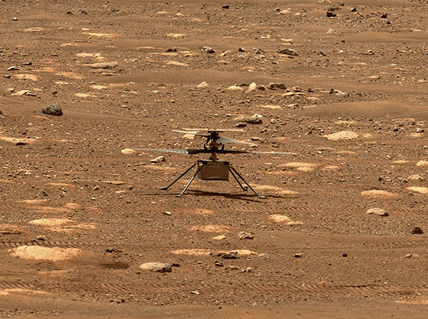
Integrity sits safely on Mars following an in-flight anomaly. (Photo: NASA)
PNT Issue Rocks Ingenuity
The Mars drone Ingenuity uses an inertial measurement unit (IMU) to track position, velocity and attitude. The IMU works with the rotorcraft’s navigation camera, which feeds images into the system. About 54 seconds into Ingenuity’s sixth flight on May 22, a glitch in the pipeline of images delivered by the camera caused Ingenuity to buck. The glitch caused a single image to be lost, resulting in all later navigation images being delivered with inaccurate timestamps. Ingenuity’s navigation system attempted to correct itself due to “phantom errors,” but the copter still managed to land within 16 feet (5 meters) of its target location. The Perseverance rover snapped an image of its flying companion the next day. The timing vulnerability is being addressed.
The versatility of the ZEB-Horizon device enabled the Deep Time team to map the complex and challenging environment. (Photo: GeoSLAM)
Measuring Deep Time and Space
Geospatial 3D mapping specialist GeoSLAM provided the technology to scan one of Europe’s largest caves as part of the Deep Time isolation study. For 40 days, 15 participants set up camp in the Lombrives cave in southwestern France with no clocks or sunlight, and zero contact with the outside world. Conducted by the Human Adaptation Institute, the experiment aimed to gain insight into human adaptability to isolation. For their first task, the “deeptimers” used the ZEB-Horizon to conduct a digital scan of the 3-km Lombrives cave — a system consisting of both narrow passages and expansive chambers up to 70 meters in height, formed more than 125 million years ago.
Photo: Nearmap
Avengers Assemble!
On June 4, Disney unveiled its Avengers Campus at its California Adventure park. Aerial image provider Nearmap, which has been flying over Disneyland and California Adventure twice a year since 2014, shared a bird’s-eye view of the park’s new area, which replaced “A Bug’s Life.” Nearmap also shared images comparing the crowd size in 2019 before COVID-19 to the reopening limit of 25% capacity in April.
Photo: Geoscience Australia
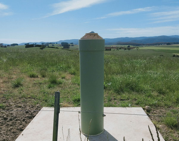
Tasmania First
As part of the Positioning Australia program, Geoscience Australia is building new GNSS ground stations. The first new station was recently completed outside the town of Derby, Tasmania. This new station joins 10 existing stations in Tasmania, providing widely available GNSS-based precise positioning signals. To access the service, users can connect to a service provider offering a fully supported service with system integration; users with specialized equipment and the technical expertise to integrate GNSS positioning can connect directly to the station via Geoscience Australia’s GNSS Data Centre.
Organizers of Commercial UAV Expo Europe have announced that the next edition of the event will take place with Amsterdam Drone Week (ADW) and EASA High Level Conference at RAI Amsterdam Convention Center, Jan. 18-20, 2022.
Previously, the events were scheduled to take place together in December 2021, but the organizers have decided — in close consultation with partners Amsterdam Drone Week and EASA — to delay the event until early 2022 due to the impact of COVID-19 on travel and the event industry.
The new date will offer partners, speakers, visitors and delegates more certainty to travel to Amsterdam and thus bring the worldwide UAM/UAS community together. Future editions will revert to the usual December time frame.
“The benefit of co-locating the three events is in bringing the whole drone ecosystem together in one place where professionals can learn, connect and drive the industry forward,” said Lee Corkhill, group event director at Diversified Communications, organizer of Commercial UAV Expo Europe. “Commercial UAV Expo Europe is the leading international trade show and conference in Europe for the commercial drone market delivering sUAS manufacturers and end-users. Amsterdam Drone Week focuses on Urban Air Mobility and the role of cities. The EASA High Level Conference focuses on the stakeholders involved in UTM and regulatory issues.”
During ADW 2021, the EASA High Level Conference will take place on Jan. 18-19 and the Commercial UAV Expo Europe will be held on Jan. 19-20.
ADW will offer a hybrid option in January 2022, meaning content from the ADW mainstage will be broadcast daily, including matchmaking and online speed networking sessions.
In 2020, ADW organized a successful online event. “Although it was a great success given the circumstances, we prefer to see the fast-growing industry around drones and unmanned aircraft back in Amsterdam in person,” said Paul Riemens, CEO RAI Amsterdam. “Bringing people together is part of the DNA of RAI Amsterdam.”
“Innovative Air Mobility is an area of intense activity for EASA. We are steadily putting all the rules in place for these operations and working on certification for these entirely new types of aircraft,” said EASA Executive Director Patrick Ky. “The High Level Conference at ADW is an important platform for discussions with a range of stakeholders on these developments.”
Commercial UAV Expo Europe, taking place as part of Amsterdam Drone Week along with the EASA High Level Conference, is a leading international trade fair and conference in Europe focusing on the integration and operation of commercial UAS. Industries covered include
Construction
Drone delivery
Energy and utilities
Forestry and agriculture
Infrastructure and transportation
Public safety and emergency services
Security
Surveying and mapping
The next edition will take place 18-20, 2022 at RAI Amsterdam.
Commercial UAV Expo Europe is presented by Commercial UAV News and organized by Diversified Communications, organizer of Commercial UAV Expo Americas, Geo Week, and Geo Business Show. For information about exhibiting at Commercial UAV Expo contact Katherine Dow, Sales Manager, at [email protected] or +1.207-842-5497. For attending information, visit www.expouav.com or email [email protected].
EASA High Level Conference
The main theme of the EASA High Level Conference will be “UAM Becoming a Reality.” Main topics are:
Multi-Level Governance of Urban Skies
Integration of new entrants in Urban Airspace and overall U-space-ATM integration
Mobility Hubs: drone and eVTOL landing sites and vertiport.
The outcome of EASA Social Acceptance study and status of the implementation of the key findings will be discussed. There will be presentations and discussions on concrete implementation projects.
In addition, educational and technical sessions, workshops and roundtables will be held on, among others, the application of the guidelines related to design verification of UAS, technical requirements on vertiports, counter drones technology and U-Space implementation.
Amsterdam Drone Week
Amsterdam Drone Week is the global platform for sharing knowledge on current air solutions, potential innovations, and vital regulations. Creating valuable connections with all key players, knowledge institutes and authorities to co-create and cooperate to build the UAM ecosystem. Through live and virtual summits, expert sessions and matchmaking, ADW connects the entire UAM value chain around drone regulations, new technology and future solutions.