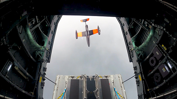
Germany has successfully launched the Future Combat Air System (FCAS) Remote Carrier demonstrator, released by an A400M.
The launch was carried out by the Bundeswehr Technical Center for Aircraft and Aeronautical Equipment (BAAINBw) and the German Aerospace Center (DLR), with collaboration from Airbus and German companies SFL and Geradts.The Remote Carrier demonstrator — an altered Airbus Do-DT25 drone — was launched from a device created specifically for the A400M to release remote carriers.
After the remote carrier was launched, its Do-DT25 engines were ignited, and it continued to fly. Controls from the A400M were then handed to the ground operator who landed the drone successfully.
As a part of the launch, the A400M was also evaluated to determine its role in FCAS to serve as a UAV launcher. Because the launch results were successful, Airbus is aiming to have the multi-role air lifter serve as the host of remote carriers.
The remote carriers and A400Ms will have an integral role in expanding the use of unmanned systems by Airbus’s military transport aircraft in the FCAS.
The private spaceflight company, SpaceX, has undertaken a partner project in addition to its existing space efforts ranging from sending satellites and people to space, to providing a brand of commercial internet connection to remote areas.
The new partner project, Starshield, will join Starlink in providing secure, broadband internet connection to customers. However, there is a stark difference between the partner projects.
Starlink technology has end-to-end user data encryption to secure its network as it was designed for commercial customers. However, the Starshield project is intended for government use in national security efforts. Therefore, it is equipped with an additional high-assurance cryptographic feature to host payloads and process data in a secure way aligning with government national security requirements.
As reported by SpaceX, Starshield has three focus areas including: Earth observation, global communications, and hosted payloads. Starshield’s satellites can integrate with a variety of different payloads and the constellation has a low-Earth orbit (LEO) design making it robust to on-orbit assets.
SpaceX continues to work closely with the United States Department of Defense by providing innovative space technology.
AeroVironment’s Puma is hand-launched. (Photo: Lance Cpl. Frank Cordoba/U.S. Marine Corps)
AeroVironment Inc. has introduced Puma VNS, a visual-based navigation system for its Puma 2 AE and Puma 3 AE small unmanned aircraft systems (SUAS). The system enables navigation across GPS-denied environments.
Puma VNS will receive frequent software and hardware updates, providing operators with advanced navigation capabilities, features and functionality. The system will also enable integration of future autonomy capabilities.
“Puma VNS gives operators an unprecedented advantage in the battlefield,” said Trace Stevenson, AeroVironment vice president and product line general manager for SUAS. “Operators now can execute missions with more confidence in GPS-contested environments with the system’s new navigational capabilities.”
VNS uses a suite of downward-looking sensors to gather imagery data and track features on the ground, as well as an embedded computing module to process and determine the precise location of an aircraft while in flight. The system automatically transitions to and from GPS-denied navigation mode without operator input.
Puma VNS is available as an add-on option for new Puma 3 AE system orders and as a retrofit kit for fielded Puma 2 AE and Puma 3 AE systems.
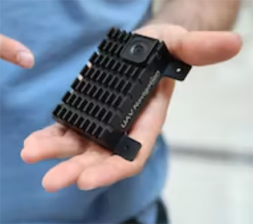
The Visual Navigation System improves navigation in GNSS-denied environments by means of visual odometry techniques
Photo: UAV Navigation
UAV Navigation has released its new Visual Navigation System (VNS), a new capability for manufacturers and end users of NATO Category I and II unmanned aerial systems (UAS).
The compact and lightweight device — provided as an optional peripheral to the main flight control system — enables the safe and efficient navigation of UAVs in GNSS-denied environments. The VNS combines visual odometry techniques and pattern identification with the rest of the sensors onboard the aircraft to ensure that the absolute position, orientation and relative movement of the aircraft over the ground is calculated with extremely high accuracy.
The planning and execution of UAV missions in environments in which the GNSS signal is either unavailable or unreliable is becoming more critical. For some missions, the datalink to the ground control station may be subject to interference, or the operation dictates that the flight must be performed without a datalink from the outset.
Under these circumstances, UAS traditionally rely on an inertial navigation system (INS) to complete the mission. However, all such inertial systems accumulate navigational drift due to sensor noise, propagation models and the difficulty in characterizing external forces. This positional error limits any such UAS operation because an accurate position cannot be guaranteed.
The new VNS, combined with the company’s Vector range of flight control systems, effectively addresses this problem by using data independent from GNSS and more accurate than INS. The system identifies patterns in the terrain below to assist in canceling out any accumulated error, allowing the UAS to operate for long periods without losing positional precision.
Because of its reduced size and weight, the VNS can be installed in Category I and II UAS, enabling them to take advantage of this navigation technique without penalizing autonomy or payload capacity.
The new VNS — developed entirely by the Spanish company UAV Navigation, part of the Oesía Group — has produced outstanding results during flight testing, both on fixed-wing platforms (typically with higher airspeeds and greater service ceilings) and rotary-wing platforms (where high vibrations and hover maneuvers are typically a problem). The new VNS has proved its ability to provide accurate navigation information for flights where there may be an intermittent loss of GNSS signal, and also when a flight must be executed from the outset without GNSS data.
The Autel Robotics Dragonfish Lite and Pro UAVs are now available in the United States, joining the Dragonfish Standard and providing more options and choices for UAV pilots.
The rugged Dragonfish UAVs are capable of vertical takeoff and landing (VTOL) with both multi-rotor and winged flight, with an endurance of up to 180 minutes. They are suitable for professional applications such as energy, mining, defense and surveillance. Maximum winged flight speed is 30 m/s (108 km/h, 67 mph), and maximum video transmission range is 30 km (18.6 miles) with a base station.
The 1-tap take-off and landing capability point-and-click user interface, and other smart autonomous features make the Dragonish simple for anyone to operate, according to maker Autel Robotics. The aircraft can make a smart decision to either land or return to base in case of issues such as loss of GPS signal, loss of operator communications, or low battery power.
The Dragonfish tilt-rotor system will automatically transition to multi-rotor mode if adverse conditions cause fixed-winged flight to stall or become unsustainable. The Dragonfish battery, barometer, positioning system, compass and inertial measurement unit all have backup modules to ensure flight safety.
Dragonfish UAVs can carry a variety of payloads, including standard high-resolution cameras, 50x optical zoom cameras, 12-megapixel wide-angle cameras, 1280 x 1024 high-resolution infrared cameras, and laser rangefinders for various imaging, surveillance and mapping tasks.
All Dragonfish UAVs are built from tough carbon-fiber and fiber-glass composite, providing excellent IP43 wind and weather resistance. Despite the strong construction, these aircraft are designed to be easily disassembled for space-saving transport. They can be assembled in three minutes without tools. Disassembled, Dragonfish fits in the back of any car or SUV.
The larger Dragonfish Pro provides the longest flight time of the series, 180 minutes with payload, and has a 6,000-m (19,685-ft) flight ceiling, making it suitable for applications such as discreet long-endurance surveillance and wide-area mapping. The maximum payload capacity is 2.5 kg.
Compact and lightweight at 4.5 kg (including two batteries) with a 1,600-mm wingspan, the Dragonfish Lite can carry a 1-kg payload up to its service ceiling of 4,000 m, and has 75 minutes’ flight endurance.
Dragonfish Standard is already available. Dragonfish Lite and Dragonfish Pro will be available in the U.S. starting in April.
Firmware Release
The company also announced that pilots of Autel Robotics’ EVO Nano and EVO Lite series drones can download a firmware update that adds features including Dynamic Track 2.1 (person only), SuperDownload, 8-bit Log video, HDR video and other improvements. Some of these new firmware features are available now for selected models, and other features will become available for the EVO Lite, Lite+, Nano and Nano+ series in the near future.
Photo: U.S. Army/Spc. Brooke Davis, Operations Group, National Training Center
BAE Systems has unveiled its ultra-small MicroGRAM-M GPS receiver that receives the new M-code military GPS signals resistant to jamming and spoofing.
About the size of a postage stamp, MicroGRAM-M is a small, lightweight and power-efficient M-code embedded GPS receiver, capable of delivering assured positioning, navigation and timing (PNT) for size-constrained and other micro-applications.
“We’re delivering reliable PNT where our customers need it — from soldiers’ handheld devices to small unmanned aerial vehicles,” said Greg Wild, director of Navigation and Sensor Systems at BAE Systems. “MicroGRAM-M provides our armed forces and allies with a low-SWAP M-code GPS solution that’s resistant to adversaries’ disruption efforts in highly contested environments.”
MicroGRAM-M features rapid, secure GPS signal acquisition, enhanced security and resiliency, anti-jamming and anti-spoofing capabilities, and very low power consumption for an M-code device. The 1.0 x 1.25 x 0.275-inch MicroGRAM-M has the same physical dimensions as its predecessor, enabling quick upgradability to M-code and reduced system integration costs. At its core is a proven, tamper-proof M-code Common GPS Module that encapsulates classified data and signal processing.
“MicroGRAM-M is the latest BAE Systems M-code military GPS product, joining MPE-M and NavStrike-M, which deliver enhanced awareness in highly contested environments and precision munitions guidance,” said John Watkins, vice president and general manager of Precision Strike & Sensing Solutions at BAE Systems. “Qualification of MicroGRAM-M is underway, with full-rate production expected in 2022.”
Delivering M-code User Equipment to Germany
On June 29, BAE Systems received the first contract from the Space and Missile Systems Center’s Space Production Corps to deliver M-code military GPS user equipment to Germany. Under a Foreign Military Sales contract, the company is delivering the advanced M-code GPS technology to Germany, enabling precise, resilient, and secure geolocation and positioning capabilities that improve the effectiveness of allied operations.
The German FMS order focuses on BAE Systems’ Miniature PLGR Engine — M-code (MPE-M), which delivers precise positioning, navigation and timing capabilities; anti-jamming and anti-spoofing capabilities; a modern security architecture; and a size suitable for space-constrained applications.
BAE Systems will provide the first MPE-M receivers to Germany for integration, test and evaluation in 2021. Work on the program will be performed at BAE Systems’ facilities in Cedar Rapids and Coralville, Iowa.
“Crime is common. Logic is rare. Therefore, it is upon the logic rather than upon the crime that you should dwell.”
“Data! Data! Data!” He cried impatiently. “I can’t make bricks without clay.”
— Sherlock Holmes, “The Adventure of the Copper Beeches,” Sir Arthur Conan Doyle
Watson is to Holmes what information is to intelligence. Watson could listen to the client story, observe the situation, and recite to Holmes all the relevant facts, but he lacked the ability to string together the seemingly random pieces of information into a coherent chain of events leading to the correct hypothesis. A computer can become a Watson, but it takes a human to be Sherlock; however, a human misguided by cognitive biases will end up as Inspector Lestrade, always coming to the wrong conclusion.
When it comes to data, the analogy of drinking from a fire hose is an understatement. Consider that a digital image can be terabytes in size and every day millions of images are taken. Facebook generates 4 petabytes of data daily, and each day there are 500 million tweets and 306 billion emails. Additionally, there are 20 billion connected devices. Combined, the world creates 2.5 quintillion bytes of data every day. If a grain of sand represents a byte of data, then every three days more data is created than there are grains of sand on the Earth, and it is only increasing.
Somewhere in all that data are signals. Real-time threat intelligence systems are looking for those signals before the next huge event occurs. It is a high-stakes hunt for Leviathan, except that Leviathan is only a packet of sand traveling at lightspeed through a cloud obscured by dust.
Nellis Air Force Base takes part in Red Flag 15-2 at its Combined Operations Center in 2015. (Photo: Senior Airman Thomas Spangler/U.S. Air Force.)
Interpreting a Signal
The massive volume, variety and velocity of continuously flowing data far surpasses the ability of humans to process. It exceeds the bandwidth most systems can handle. And it quickly overwhelms the capacity to store, manage and act on the information in a timely and cost-effective manner. Resources are not infinite. The best model to handle an overwhelming amount of data is the human brain. Humans are biological sensors. Every moment of every second of our lives, our bodies are receiving an endless stream of stimuli from internal and external sources. Most of this stimuli registers at an unconscious level, and as long as the stimuli is normal and expected, it goes unnoticed by the conscious mind. If, however, any discomfort is experienced, the conscious mind is notified. Then that becomes the focus until normalized. Externally, the same applies to computer data systems. Normal conditions are ignored, but if there is something unusual, such as a loud constant noise, or a colder than normal temperature, it draws all the processing attention.
In the realm of intelligence that is basically how things function. Algorithms are written to learn the normal patterns of life and to identify specific events, words, names, etc. As long as data is within normal parameters, it gets little attention, but as soon as an anomaly exceeds a threshold or something triggers the algorithm, it will immediately be brought to the attention of the intel center. An example can be viewed on the Global Incident Map dashboard. I encourage you to sign up for a free 72-hour membership. If you want to see what real news looks like, this would be a sampling. The number of real incidents that happen across the country and around the world that you never hear about, many of them hair-raising and all of them open source, add to the few stories the media has been able to tell about cyber attacks. Scroll down the page. There are many filters, but I recommend turning them all off to see the full extent of information. Clicking on an incident will drill down into the actual source so you can read about it more thoroughly.
Below is the U.S. Army’s real-time critical incident dashboard called the Joint Analytic Real-Time Virtual Information Sharing System (JARVISS). It tracks and monitors activity near U.S. Army installations and standalone assets of interest around the world.
Another dashboard for cyberattacks is Check Point, which shows just how aggressive cyberthreats are throughout world. Here, you can see the patterns of coordinated attacks. A war is underway. The soldiers are cyberwarriors. No country is safe. View the Live Cyber Threat Map.
JARVISS is designed to target criminal activity and provide natural disaster information in and around Army installations and stand-alone facilities, as well as COVID-19 threats. (Image: Steve Gardner/U.S. Army}
Fast Analysis in Real Time
Monitoring this information, analysts look for connections. If a plane veers off its flight path, the local operations center is notified. An automatic query shows if any critical-infrastructure assets or other important structures and facilities are in the area. The analyst can immediately find out the type of aircraft, the call sign, who the plane is registered to and who filed the flight plan. Weather radar can be overlaid to see if that is a possible reason for the deviation. Incident reports can be displayed in real time within the area of interest, along with social media feeds and other sources of communication. Traffic patterns can be displayed.
The important question that needs to be answered is whether this is a potential threat. Is there a connection to anything going on anywhere else? A dossier is developed on the person who filed the flight plan, the one who is assumed to be the pilot and the person or organization to which the plane is registered. All of this is being done in a matter of minutes, while the airplane either returns to its flight path or continues its diversion. The air traffic control tower is contacted to share information on the aircraft and its deviation. If the tower does not have an answer, it will radio the pilot for an answer. The passenger and crew manifest also are analyzed. All the data that can be pulled together — including the remaining fuel burn and the aircraft performance limitations — are analyzed.
Patterns emerge from the data. These patterns lead backwards to a cause and forward toward the end result. Finding those clues in the data requires a team of specialists from six primary intelligence disciplines.
An imagery intelligence analyst brings in the live-streams and remote sensing.
A human intelligence analyst seeks motivating factors and ways to deescalate the situation.
A measurements and signatures intelligence specialist defines the operating limitations and the mechanics and science particular to the scenario.
An open-source intelligence analyst accesses and queries open-source data sets to provide clues.
A signals intelligence specialist focuses on the communications and electronic signatures.
A geospatial intelligence analyst brings it all together and provides spatial context through the map the team uses that shows the events unfold in real time.
These analysts and sometimes many others will collect all these pieces of information and turn them into intelligence that decision-makers can use to take action. That is the purpose of intelligence; as CIA veteran Richard Heuer stated, “Intelligence seeks to illuminate the unknown.”
Fortunately, most alerts turn out to be false positives, but every one of them is treated as if it were “the one.” These false positives turn out to be excellent, real-world exercises that hone the skills of the team and wire the brain for speed. These events can last mere minutes or several hours. It’s an adrenaline rush.
To explore live streaming data feeds, Esri has a growing volume of data in its ArcGIS Living Atlas.
“My mind rebels at stagnation. Give me problems, give me work, give me the most abstruse cryptogram, or the most intricate analysis, and I am in my own proper atmosphere…”
— Sherlock Holmes, “The Sign of the Four,” Sir Arthur Conan Doyle
William Tewelow works for the Federal Aviation Administration. He is a graduate of a management fellowship program. While on special assignment to the U.S. Department of Transportation William led the project to crowdsource the National Address Database for the White House Open Data Partnership. He is a Geographic Information Systems Professional (GISP) and a Maryland Scholar STEMnet Speaker. He has a degree in Geographic Information Technology and Intelligence Studies from American Military University and is currently earning a degree in Organizational Leadership. William retired from the U.S. Navy after serving 23 years as a Geospatial and Imagery Intelligence Specialist, a Naval Aviator, a Meteorologist, and a Tactical Oceanographer. He was among the first in the nation to earn a Geospatial Specialist Certification from the U.S. Department of Labor while working at NASA Stennis Space Center in Mississippi. He is married, enjoys traveling, solving problems, playing with data, and fascinated by new technology and historical context. His favorite quote is, “A man’s mind changed by a new idea can never go back to its original dimension.” ~ Oliver Wendell Holmes
BAE Systems is investing more than $100 million to build a state-of-the-art facility in Cedar Rapids, Iowa, expected to be completed in 2022. The facility will support the company’s newly acquired Navigation & Sensor Systems business, which makes mission-critical military GPS products.
The new building will bring the company’s local design and production employees from multiple locations into a single center of excellence with modern manufacturing, engineering and office space.
“Our world-class military GPS business is built on the rich talent pool in Greater Cedar Rapids,” said John Watkins, vice president and general manager of Precision Strike & Sensing Solutions at BAE Systems. “This investment will provide our high-tech engineering and manufacturing experts with a world-class workspace and the tools to enhance operational excellence.”
The facility will improve operational efficiency, optimize production, and enhance the company’s ability to deliver high-quality military GPS products to the warfighter.
The 278,000-square-foot research and development center will be located on a 32-acre site. The building will include a large factory; several hundred offices, workstations, and flexible work spaces; and classified and unclassified labs. The building was designed for growth, with the ability to add 50,000 square feet of additional space.
The JNC, sponsored by the Military Division of the Institute of Navigation, will be held Aug. 24-26 (FEDCON U.S. ONLY) at the Northern Kentucky Convention Center in Covington, Kentucky (Greater Cincinnati, Ohio).
The Classified Sessions (Secret U.S. ONLY) will be held Aug. 27, at the Air Force Institute of Technology on Wright-Patterson Air Force Base, Ohio. Visit requests and approvals are required for all session attendees.
View the JNC 2021 program and register at ion.org/jnc.
JNC 2021 is the largest U.S. military positioning, navigation and timing (PNT) conference of the year, with joint service and government participation.
Four new panel sessions have been introduced to this year’s technical program, which will host leaders and decision makers as they discuss and debate
MGUE Integration
Rapid Agile Development and Manufacturing
the National Critical Infrastructure Threat
Combatant Command Joint Urgent Operation Need (Secret, U.S. Only).
The technical program will focus on enhancing dominance and resilience for warfighting and homeland security PNT, and will include keynote addresses from:
William B. Nelson, director, Assured Positioning Navigation &Timing (APNT) Cross Functional Team (CFT), U.S. Army Futures Command
Ray Chartier, Jr., Safety of Navigation Mission manager, National Geospatial Intelligence Agency
General David D. Thompson, vice xhief of Space Operations, United States Space Force
Bradford Parkinson, Stanford Center for PNT
Attendance Restricted for JNC Technical Sessions
Conference attendance for both FEDCON (U.S. ONLY) (Aug. 24-26) and Classified Sessions (U.S. ONLY) (Aug. 27) will be screened by the Joint Navigation Warfare Center. Visit requests and approvals are required for all technical participants.
The exhibit hall is open to any registered conference attendee or exhibiting company representative, and all materials shall be designated DISTRO A/Publicly Releasable After Review.
Government-issued photo ID will be required to access all conference events.
If you have questions, contact the Institute of Navigation at [email protected] or by calling +1-703-366-2723.
Zala Aero Group unveiled the ZX1, a new hybrid unmanned aerial vehicle (UAV), at the 2021 International Defense Industry Exhibition (IDEX) and Conference, which opened on Feb. 21 in Abu Dhabi.
The new drone has vertical-takeoff-and-landing (VTOL). According to Zala, it combines the best qualities of fixed-wing and multirotor types of UAVs; its configuration can change depending on the conditions of the performed task.
Ease of operation allows the UAV system to reduce the operator’s role, decrease the amount of equipment used when performing a flight mission, and fully automate flight processes of the UAV.
The ZX1’s onboard computer uses artificial intelligence, which makes it possible to process data in full high-definition, and transmit HD video and photos via encrypted communication channels to the GCS, ensuring the effectiveness of monitoring even before the aircraft lands.
The VTOL design makes it compatible with existing ZALA payloads, and also allows the installation of additional surveying equipment. It can be used to perform air monitoring for the fuel and energy sector and search-and-rescue operations from sites in urban environments.
Zala Aero Group, founded in 2004, is a Russian developer and manufacturer of unmanned aerial systems, payloads and mobile systems. It is now part of Concern Kalashnikov. Its main products are reconnaissance unmanned systems and digital solutions. Currently, more than 2,000 of Zala UAS operate within Russia. Areas of application are the protection of state borders, reconnaissance and rescue operations, monitoring of high-risk facilities and emergencies.
French ministry for Armed Forces selects Airbus Survey Copter Aliaca fixed-wing drone systems to equip its ships
Airbus Defence and Space mini UAS subsidiary Survey Copter signed a contract with French DGA Armament general directorate to provide the French Navy with 11 systems, (22 aircraft), of the electrically powered fixed-wing Aliaca maritime version UAS (officially called SMDM / “Systèmes de Mini Drones aériens embarqués pour la Marine” by French authorities), including training and integrated logistic support. First deliveries are expected in 2021.
“We are honored to contribute to the missions of the French Navy which we will support with the highest standards of quality and reliability,” said Nicolas Askamp, head of Survey Copter/Airbus Unmanned Aerial Systems. “This new contract strengthens Survey Copter’s position as a global key player for maritime mini UAS.”
The Aliaca maritime UAS is a high-endurance versatile system allowing up to 3 hours missions over a 50 km (27 Nm) range, perfectly adapted to maritime missions with high gyro stabilized EO/IR payload performances and qualified to operate in severe environmental conditions.
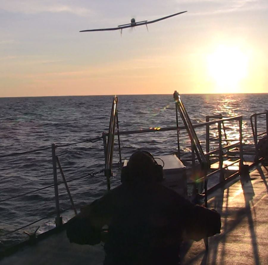
The Aliaca SMDM is catapulted from a ship deck. (Photo: Airbus Defence and Space)
Launched by catapult, the Aliaca maritime UAS concludes its flight by landing automatically using a dedicated net landing solution. With a length of 2,2m and a wingspan of 3,6m for a maximum take-off weight of 16 kg., the Aliaca maritime UAS benefits from a powerful yet silent electric motor. The system can be deployed easily and rapidly in less than 15 minutes by 2 operators only.
Similarly, the user-friendly ground control station enables the operator to constantly monitor the automatic flight of the UAS while receiving in real-time day and night images and AIS (Automatic Identification System) data gathered by its on-board sensors.
It is designed to conduct several types of missions around the ships, including increasing the understanding of the tactical situation, control of illegal operations at sea, search-and-rescue, traffic monitoring, pollution detection, tracking of any suspicious behavior in the ship environment and coastal surveillance.
This light on-board aerial solution gives the opportunity to vessels, traditionally not equipped with aerial assets, to enhance their tactical ISR capabilities, support decision making and reactivity in operations.
The Aliaca maritime UAS can easily be integrated on board any ships, with or without helicopter landing-deck, and its small logistic footprint enables operations and storage on board smaller sized ships. Its integration does not require heavy on-board modification nor storage of specific fuel.
The result of 10 years of R&D investments and on-board experimentations, SURVEY Copter’s off-the-shelf Aliaca maritime UAS is a robust and resistant system to the corrosive maritime environment, an adapted solution to the electromagnetic constraints on board, and benefits from an efficient net recovery system, fully automated, meaning that no human action is required during the recovery phase.
According to DSI, the event will bring together members of the military services, Department of Defense (DoD), federal government, industry and academia in a “town hall” style forum to discuss how important GPS and space-based PNT systems are to the overall resilience of the warfighter, as well as critical infrastructure across the United States and abroad.
The 2021 Assured PNT Summit also will offer senior-level insight into how the U.S. military has been a leader in integrating PNT into its everyday operations and how such capabilities have become vital to the military’s ability to shape the global arena, deter aggression, and fight and win wars.
Confirmed speakers for this year’s event include William Nelson, SES, director, APNT CFT, Army Futures Command; Brig. Gen. Heather L. Pringle, USAF, commander, Air Force Research Laboratory; Anthony C. Smith, SES, director, C3I, DoD CIO; Richard De Fatta, SES, director, U.S. Army Space & Missile Defense Center of Excellence; Cordell “Del” DeLaPena, SES, program executive officer for Space Production Space & Missile Systems Center, USAF; Harold W. Martin III, SES, director, National Coordination Office for Space-Based Positioning, Navigation and Timing; and Col. Jason Joose, USA, chief of staff/APNT signature effort lead, Army Futures Command.
A number of topics will be covered at the 2021 Assured PNT Summit, including:
Leading current DoD initiatives toward integrating new PNT capabilities to help the Warfighter remain resilient in a dynamic threat environment;
Synchronizing PNT, navigation warfare and space capability development efforts across the Army to help reduce key capability gaps;
Delivering resilient, affordable and sustainable space capabilities such as modernized GPS to enhance warfighter superiority;
Providing alternate PNT for potential GPS-denied environments;
Accelerating the implementation of cutting-edge Air Force research projects such as NTS-3 GPS Satellite to provide the most value to the warfighter;
Developing critical PNT-related products to enable a Soldier’s PNT capabilities in all warfighting domains;
Overseeing the collection of GPS-related information from multiple federal agencies in an effort to improve and maintain space-based PNT capabilities;
Advancing efforts to provide GPS protection for all naval air platforms; and
Detailing the Department of Homeland Security plan to test the vulnerabilities of critical infrastructure systems, networks and assets if PNT services were to be disrupted or manipulated.