Apogee has been awarded a five-year, $103 million task order to provide positioning, navigation and timing (PNT) support services for the U.S. Department of Defense.
The contract supports modernization, acquisition and sustainment planning across the international PNT enterprise, ensuring resilient and reliable capabilities that underpin critical military operations worldwide.
Under the contract, Apogee will deliver technical expertise and mission support across multiple locations, including Robins Air Force Base, Georgia; Wright-Patterson Air Force Base, Ohio; and Eglin Air Force Base, Florida.
Apogee’s team will contribute to advancing next-generation PNT capabilities, strengthening system performance and supporting the continued evolution of a mission essential to joint and coalition operations.
Apogee is headquartered in Colorado Springs, Colorado, with regional offices nationwide.
Artist’s rendering of GPS IIF satellite. (Image: U.S. Air Force )
Boeing has secured a 10-year, $329.3 million contract to help the U.S. Space Force engineer operational GPS Block IIF satellites, the Department of Defense announced Dec. 20.
The company will perform engineering work to support on-orbit operations of the Block IIF satellites, which were manufactured by Boeing.
Space Systems Command issued the indefinite-delivery/indefinite-quantity contract to address GPS IIF mission requirements across the military and expects work to conclude by Dec. 20, 2031.
The U.S. Air Force deployed the first Boeing-built IIF satellite in May 2010 and launched the 12th and final satellite in February 2016.
Up to five-year contract follows a successful pilot program that demonstrated the value of commercial RF geospatial intelligence
HawkEye 360 has been awarded a contract by the National Geospatial-Intelligence Agency (NGA) to help the agency discover, characterize and map activities that emit energy in the radio frequency (RF) bands of the electromagnetic spectrum.
HawkEye 360 specializes in RF data and analytics from space-based satellites.
HawkEye 360 will provide NGA the means to develop global datasets, enabling users to discover and monitor a broad range of RF activity across large geographic areas.
The $10 million one-year contract includes an option for four more years. It will support users throughout the NGA enterprise, including the combatant commands and other mission partners.
HawkEye 360’s data will support a variety of analytics missions for NGA, including military activity and the trafficking of military, nefarious, non-state and transnational criminal (or illicit) activity. The company’s growing constellation of satellites will provide insight into developing events in a timely manner, and the company will work collaboratively with NGA on an ongoing basis to effectively meet the agency’s mission needs.
“We’re pleased to be moving from the pilot into an NGA long-term operational contract, which showcases the value of unclassified, shareable commercial RF insights,” said HawkEye 360 CEO John Serafini.
“This program is an excellent example of agile acquisition rapidly delivering high-impact GEOINT to the warfighter,” said Alex Fox, the company’s executive vice president for business development, sales and marketing.
NGA leveraged a National Reconnaissance Office commercial integration study contract with HawkEye 360 in September 2020 to execute a test and evaluation contract with the company.
NGA then issued a competitive RFP in March 2021 and awarded the contract in July 2021. “We are excited to continue working with NGA to address current mission requirements and expand the RF GEOINT tradecraft to address an even larger set of mission requirements, much like NGA has done with their pioneering use of commercial imagery,” Fox said.
HawkEye 360 operates a constellation of nine RF-monitoring satellites. Twenty-one additional satellites are fully funded and scheduled for launch in 2021 and 2022. Once complete, this baseline constellation of 30 satellites will provide collection revisits as frequently as every 20 minutes.
Following the establishment of the baseline constellation, HawkEye 360 plans to launch a second-generation constellation of 30 additional satellites by 2025 to satisfy projected capacity and operational requirements.
The company’s RF data and analytics produce actionable insights for national, tactical and homeland security operations, maritime domain awareness, environmental protection and a growing number of new defense and commercial applications.
The non-ITAR status greatly increases the marketability of the SDI500/SDI505 IMUs to international customers. Plus, Emcore releases new SDI170 IMU and is awarded defense contract.
Emcore’s dual-use SDI500/SDI505 Revision F inertial measurement units (IMUs) have received a determination that they are not subject to the International Traffic in Arms Regulations (ITAR) administered by the U.S. Department of State. Emcore has likewise determined that its SDN500 inertial navigation system (INS) is not subject to ITAR.
The determination of non-ITAR status is expected to dramatically increase the size of the market that Emcore can address with its quartz micro-electro-mechanical systems (QMEMs) IMU and INS devices.
Photo: Emcore
Ranked Top in Trade Study. The SDI500/505 IMU was ranked first in overall accuracy, reported Emcore, in a U.S. military-commissioned trade study of 19 IMUs being evaluated as an alternative to the Honeywell HG1700 for various weapons systems.
The objective of the third-party independent study was to deliver a comprehensive report to the government and make a recommendation supported by clear and compelling technical, financial, and other relevant data collected regarding the most advantageous IMU products and services available in the market today. 19 IMUs of various technologies, complexity, cost, and developmental status, from leading manufacturers, were evaluated in short and long flyout simulations against the HG1700.
The dual-use non-ITAR SDI500/505 IMUs are designed to achieve the demanding performance levels required in sophisticated systems, including weapons guidance and targeting, commercial and defense fixed-wing aircraft and helicopters, unmanned autonomous vehicles (UAVs), and a wide variety of other high-precision commercial, industrial, marine, defense and space applications. They leverage quartz MEMS technology to deliver angle random walk (ARW) values of 0.02°/√hr with 1°/hr bias stability.
Defense Contract Award. In March, Emcore was awarded a development contract valued at $1.1 million by a major U.S. prime contractor to design and manufacture a high-end IMU for tactical intelligence and reconnaissance systems. The prototype phase has been successfully completed and as part of the contract in this follow-on phase, Emcore will deliver initial production units that will be used for proof of manufacturing and system level qualification.
The custom IMU will be based on Emcore’s proprietary closed-loop fiber-optic gyro (FOG) technology that delivers proven CSWaP (cost, size, weight and power) and performance advantages over other FOGs and competing technologies. It is designed to deliver the highest level of performance in Emcore’s tactical IMU product line, exceeding Emcore’s EN-300. Emcore’s FOG IMU technology delivers ten times the bias performance of legacy systems in compact form-, fit- and function-compatible packages.
New SDI170 IMU. Emcore also launched a replacement IMU. The new SDI170 quartz MEMS tactical-grade IMU is designed as a form-, fit- and function-compatible replacement for the HG1700-AG58 ring-laser gyroscope (RLG) IMU, but with superior overall performance, versatility and a significantly higher mean time between failures (MTBF) rating over ruggedized environments.
The SDI170 IMU is suitable for continuous-use applications with no wear-out components and delivers highly linear accelerometer performance and longer life compared to the HG1700 IMU. It is not ITAR controlled and has completed extensive internal and external customer testing to confirm compatibility to replace legacy products.
The unit is designed for a wide range of high-precision, integrated commercial and defense applications including aircraft Attitude Heading Reference Systems (AHRS), GPS-aided navigation, ground surveying, mobile mapping, ROVs, autonomous vehicles, tactical weapons, and stabilization platforms.
Non-ITAR Determination. As a result of this Commodity Jurisdiction (CJ) determination concluded by the U.S. Department of State, EMCORE’s SDI500/SDI505 Revision F commercial off-the-shelf (COTS) offerings were confirmed to be subject to the Export Administration Regulations (EAR) administered by the Department of Commerce (DOC). EAR classification typically results in fewer export-related restrictions and requirements. For this reason, this CJ determination for the SDI500/SDI505 will greatly increase the marketability of these IMUs to international customers.
The SDN500 is Emcore’s most advanced QMEMS INS/GPS tactical-grade system, combining the latest generation quartz gyros and accelerometers from the SDI500/SDI505, with high-speed signal processing and a 48-channel coarse/acquisition code GPS receiver into a powerful, tightly coupled guidance and navigation system.
“We would like to thank the U.S. Department of State for its evaluation of our commodity jurisdiction request and conclusion that our dual-use SDI500/SDI505 IMUs are not subject to ITAR,” said David Hoyh, Emcore’s director of sales and marketing for navigation products. “The determination of EAR status under the DOC enables more customers worldwide to benefit from these important, high-precision Emcore products.”
Orolia, through its Orolia Government Systems business, has been selected by Raytheon Missiles & Defense to support the U.S. Lower Tier Air and Missile Defense Sensor (LTAMDS) radar program with its low SWaP (size, weight and power), rugged time and frequency system.
Defeating hypersonic weapons
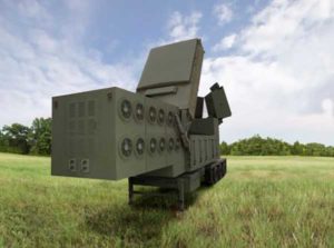
An artist’s rendering of the Lower Tier Air and Missile Defense Sensor (LTAMDS), a next-generation radar meant to help defeat advanced threats like hypersonic weapons. (Image: Raytheon/Orolia)
The LTAMDS system — an advanced air and missile defense radar — will help the U.S. Army defeat advanced threats, including hypersonic weapons. It is a radar designed to defeat advanced and next-generation threats including hypersonic weapons, or those that fly faster than a mile a second.
LTAMDS has three antenna arrays — a primary array on the front, and two secondary arrays on the back. They work together, detecting and engaging multiple threats from any direction at the same time. This results in a battlefield without blind spots, according to Raytheon.
LTAMDS’ primary array is about the same size as the array for the Patriot Air and Missile Defense System, but it has more than twice the power. It is designed for the U.S. Army’s Integrated Air and Missile Defense system, but it will also preserve existing military customers’ investment in the Patriot system.
Raytheon Missiles & Defense was selected by the United States Army in October 2019 to provide the next-generation LTAMDS.
Timing from Orolia
Orolia was chosen for the LTAMDS program based on its core expertise in resilient timing and configurable ruggedized PNT systems for challenging environments, together with its proven track record of successfully delivering time and frequency platforms for other Raytheon Programs of Record.
Orolia was the first company to receive approval for a time and frequency reference system on the Defense Information Systems Agency (DISA) Department of Defense Information Network (DoDIN) Approved Products List for network interoperability, with its flagship SecureSync system.
“Ultra-precise mission timing and sync technology are fundamental building blocks for the Resilient PNT systems that warfighters rely on for continuous operations in contested environments,” said Hironori Sasaki, president of Orolia Defense & Security. “We are proud to be a Raytheon Missiles & Defense partner on LTAMDS and other programs that utilize GPS signals for timing, frequency and network synchronization across critical military systems.”
From critical timing solutions to GPS/GNSS simulation, interference detection, and mitigation, Orolia is an industry leader in end-to-end NAVWAR and Resilient PNT solutions to protect, augment and strengthen military systems for GPS-denied environments.
Orolia Defense & Security provides resilient PNT solutions and custom engineering services to U.S. government agencies, defense organizations, and their contractors, and is authorized to work on the full spectrum of U.S. government classified and unclassified projects.
The technology multinational GMV has won a contract under the Spanish Ministry of Defense’s (MoD’s) RAPAZ program for the supply of four Class I Seeker RPASs to be integrated into the intelligence units of the Paratrooper Brigade and the Tercio de Armada de Infantería de Marina (Marine Infantry Protection Force).
The contract will provide the armed forces with the most advanced version of the unmanned aircraft Seeker.
The UAS Seeker is an autonomous, rapid-deployment system developed by Aurea Avionics and supplied by GMV. It provides intelligence, surveillance and reconnaissance capabilities over a 15-kilometer range with a 90-minute endurance and a weight of 3.5 kg.
The aircraft will strengthen the intelligence, surveillance and reconnaissance capabilities of Spanish troops, ensuring better operational capability and tactical superiority.
Seeker constitutes the core of a situational awareness system, providing real-time intelligence. It is designed for rapid-deployment and high-mobility military applications carrying out low-level intelligence, surveillance and reconnaissance tasks.
The system components can be broken down into two major groups: the air segment and the ground segment. The air segment comprises the unmanned aerial system (UAV), fit for daytime and nighttime operations and capable of completely autonomous flying. The ground segment comprises a ground control station, a ground data terminal, and a remote handheld control. These systems between them monitor the UAV’s operation and process its real-time video data.
Within this project, due for delivery by October 2020, GMV will be running the design and manufacturing activities and also the various flight campaigns scheduled to check that the systems work properly before handover to the MoD.
GMV developments for unmanned aircraft
GMV boasts great expertise and experience in Unmanned Aerial Systems (UAS), built up on the strength of many previous projects such as ATLANTE, where it developed the aircraft’s flight control computer; EGNSS4RPAS, where it weighed up EGNOS performance for RPAS operations; and DOMUS, where it developed emergency-management and -monitoring service demonstrators for drone traffic control under the U-Space system.
This Spanish MoD Seeker system supply contract boosts GMV’s growing renown as developer and supplier of UAV systems and services.
Specifically, Booz Allen’s work will aid in the development and modernization of GPS systems through major programs such as Military GPS User Equipment (MGUE), GPS III and Next Generation Operational Control System (OCX).
The NIWC Pacific Positioning, Navigation, and Timing (PNT) Division is the Navy’s principal research and development center for navigation sensors and systems.
SMC is the center of technical excellence for developing, acquiring, fielding, and sustaining resilient and affordable military space systems.
With this contract, Booz Allen will continue to serve as a key mission partner for NIWC Pacific and SMC on the important endeavor of modernizing PNT systems for U.S. and Allied warfighters.
To execute this highly complex scope of work, Booz Allen will provide a range of essential services, including system definition, requirements synchronization, capability improvement, cybersecurity engineering, platform integration and testing, and acquisition program management.
“Booz Allen’s robust track record of work in both systems engineering and cybersecurity continues to inspire trust from our clients,” said Vice President Brian Zimmermann. “Our deep bench of leaders and technical experts reassures our clients that no project is too big or too complex. It’s our privilege to help the Navy and Air Force modernize GPS systems that are so vital to the security of our nation.”
Read more about Booz Allen’s work with PNT systems here.
Staff Sgt. Reag Wood of 1st Combined Arms Battalion, 5th Brigade, 1st Armored Division, illustrates how he uses an iphone to obtain a visual image of a mock with insurgent activity during a field training exercise at White Sands Missile Range, N.M. (Photo: U.S. Army/Lt. Col. Deanna Bague)
DroneShield Ltd. has released a body-worn drone detection product, RfPatrol. Weighing under 1 kilogram, the mobile unit is expected to be of significant interest to a range of DroneShield’s customer base globally, across military, law enforcement, security and VIP markets.
DroneShield made the announcement at AUVSI Exponential 2019, being held this week in Chicago.
RfPatrol is a passive (non-emitting) product, which substantially broadens the range of customers to whom the product is lawfully available. It was developed in response to customer interest.
Already, a small quantity of the RfPatrol units has been ordered by a western country’s defense department, for evaluation with a potential larger order in the future.
“We are excited to launch RfPatrol,” said DroneShield CEO Oleg Vornik. “Due to its miniaturized/body-worn nature, substantially larger customer universe due to its non-emitting nature, and a relatively lower price point compared to fixed-site products, we expect it to have substantial appeal. In addition to being able to be used as a stand-alone, it is a perfect companion to our DroneGun product.”
KuRFS radars address urgent operational need against drone threats.
The U.S. Army awarded Raytheon Company a $191 million contract for Ku-band radio frequency radars. KuRFS, an advanced electronically scanned array system, fills an immediate U.S. Army operational need for a counter-unmanned aerial vehicle radar, Raytheon said.
Already deployed, KuRFS delivers precision fire control as well as “sense and warn” capability for multiple missions including detection of swarming UAS threats, as well as rocket, artillery and mortar threats.
Raytheon’s KuRFS radar. (Photo: Raytheon)
“Seeing threats — like swarming drones — as soon as possible on the battlefield is essential to protecting critical assets and saving soldiers’ lives,” said Andrew Hajek, senior director of tactical radars at Raytheon Integrated Defense Systems. “KuRFS makes this possible by delivering a unique combination 360-degree situational awareness, precision and mobility.”
KuRFS enables defense against multiple threat types through integration with the Land-Based Phalanx Weapon System, 50-caliber guns and 30-mm cannons. The radar also supports high-energy laser and the Coyote weapon system in both a ground-mounted or vehicle-mounted configuration, Raytheon said.
Raytheon’ KuRFS is able to quickly address the urgent needs of the army through a model of rapid-turn development and deployment, the company added. This reduces time to fielding, while providing enhanced flexibility to adapt to a quickly-changing threat environment in the drone space.
The I-want-free-advice syndrome was once called the “Doctor Syndrome” or “Expert Syndrome.” I have recently heard it referred to as the “unsolicited advice” syndrome, because there is a new version that involves shaming the expert in to giving free advice.
Occasionally those of us with expertise in an area of interest, which certainly include doctors and lawyers, are faced with tough decisions involving rules, regulations, laws and conflicts of interest.
We are all guilty of these ethical violations in one way or another. On an airplane you discover your seatmate is a doctor of osteopathic medicine; not five minutes have gone by and you are telling him or her about all your aches and pains and seeking advice. My daughter, a clinical psychologist, says this frequently happens to her, but legally it is not a syndrome, although it could certainly be described as a phenomenon.
Regardless of the nomenclature, the newest wrinkle goes like this, as stated by a congressman at our table at a fundraiser I attended recently, when he was asked about the troubled OCX program (Next Generation GPS Operational Control System) and GPS funding in general. “Well, I don’t know much about GPS or navigating, but this is what I know about OCX and GPS. I am sure Don will correct me if I am wrong…”
I mention this phenomenon because for position, navigation and timing (PNT) issues, it is growing at an alarming rate. For instance, my 10-20 emails per day asking about PNT issues have grown over the past few weeks more than tenfold. I perceive that many of you are confused and concerned about the future of GPS, PNT and GNSS in general.
With the House Armed Services Committee deleting more than $420 million from the GPS budget line for OCX in the 2017 budget and canceling funding for certain Acquisition, Technology and Logistics (AT&L) positions dealing with acquisition, there are all kinds of rumors and innuendo floating around. [Editor’s Note: the Senate did not make the same deletions, so this must be worked out in congressional committee meetings before the end of September]. So, I went out and formally asked the experts (GPS Directorate, Lockheed Martin and Harris Corp among others) what they think the future holds for GPS. Here is what I learned…
Artist’s concept of the nextgen GPS III satellite (courtesy of the USAF).
GPS III Spacecraft. According to Colonel Steve Whitney (USAF), the director of the Global Positioning Systems Directorate, Space and Missile Systems Center (SMC), Air Force Space Command (AFSPC), Los Angeles AFB, California: “The GPS III program is actively engaged in production of the first eight [GPS III] satellites (SV), while proceeding ahead with contracting actions for the ninth and tenth spacecraft. “
Colonel Whitney went on to explain, “We have had several notable successes over the last year, including delivery of the first two navigation payloads [from Harris Corp] and completion of the first spacecraft’s environmental tests (acoustic, thermal vacuum and electromagnetic compatibility). As we prepare to accept delivery of the first spacecraft, the directorate is gearing up for the Mission Readiness Campaign and satellite launch.”
I spoke independently with representatives from both Harris Corp and Lockheed Martin, and they expressed the same opinions. Work is progressing toward a launch of the first GPS III SV hopefully sometime in 2017.
Of course, all of the companies mentioned and many others are also involved in the follow-on production of GPS III satellites known officially, oddly enough, as the:
GPS III SV11 + Follow-On Production Phase One (1). According to Colonel Whitney, “The GPS SV11+ program is implementing a phased acquisition approach to determine first if viable alternate sources exist for a production-ready spacecraft. We successfully awarded three Phase 1 contracts on 5 May 2016, and are working with all three vendors to inform our follow-on approach.”
For those of you who have not been keeping up, the three Phase 1 contracts were in the amount of $5M to each company. LMCO is included in the competition and was one of the three companies. To go into a bit more detail, the three GPS III awards are firm-fixed-price contracts that are not-to-exceed $6 million; the base contract plus two $500,000 options. The base contract period of performance is 26 months, and each option extends that time by six months for a total period of just over three years or 38 months.
At the end of the competition, the GPS Directorate will award one GPS III Phase 1 Production Readiness Feasibility Assessment contract to one or more of the three companies:
Colonel Whitney’s boss, Lt. Gen. Sam Greaves, who is the Space and Missile Systems Center commander and Air Force program executive officer (PEO) for space, said: “Industry told us they were ready to compete for the GPS III space vehicles. We look forward to working with Boeing, Lockheed Martin, and Northrop Grumman to assess the feasibility of a follow-on, competitive production contract.”
The USAF has issued an artist’s concept of the GPS III satellite, but seriously, I have listened to the proposals from all three companies in detail, and the proposals are all so radically different that the picture is just that, an artist’s concept, it may not even be close to reality.
Artist’s concept of the nextgen GPS III satellite (courtesy of the USAF).
Certainly, $5-6M is not much money in the scheme of things, certainly not enough to design and build a GPS satellite from scratch, but it is a show of good faith on behalf of the U.S. government, proving they are serious in their search for a new and improved PNT satellite in the GPS III family.
Next-Generation Operational Control System (OCX). The original OCX contract was awarded for somewhere slightly south of $900M for a six-year total effort to deliver a new Full Operational Capability (FOC) ground control system for all GPS satellites except the long-lived GPS IIAs. The federal government, having watched programs like OCX go south before, took the Raytheon bid and quietly doubled it and assured everyone they had the program well in hand. The government assured us time and again that OCX would never breach Nunn- McCurdy levels as they planned for double the cost. Smart move, but OCX costs finally reached double the original estimate plus 25 percent, which triggered the Nunn-McCurdy breach on June 30.
Now Raytheon and the government have until October to decide whether to continue with the OCX program. However, Colonel Whitney and the folks at SMC remain confident; he kindly describes the current status of OCX this way: “The OCX team continues to pursue a restructured plan approved by the Defense Acquisition Executive [USD (AT&L)] and will hold its next deep dive with the Secretary of the Air Force [SECAF] and USD (AT&L) in early July [maybe this week]. Raytheon is driving for Functional Qualification Testing of the GPS III Launch and Checkout System (GPS LCS and OCX Block 0) in August 2016.”
My sources tell me that a realistic date for OCX FOC, based purely on past performance, software issues and cyber-security concerns, is 2023 with a total cost of $4.2B. This may all be academic if OCX cannot clear the Nunn-McCurdy hurdles.
The interesting story here is that there are alternatives. This brings us to the…
GPS III Contingency Operations or Cops, which Colonel Whitney described this way when I asked him about it. “We [USAF, SMC] awarded the GPS III Contingency Operations effort on 3 February 2016 on an expedited basis with the task of delivering the capability to put on-orbit GPS III spacecraft into operations, providing legacy mission capabilities. We successfully completed the Preliminary Design Review (PDR) on 11 May 2016 and are on-track for Critical Design Review (CDR) in November 2016.”s
What the Colonel meant to say — my words, not his — is that we (the U.S government) are finally hedging our bets. Just in case OCX does not come to fruition, both for launch and operations, we know we need to put a GPS III satellite on orbit soon so we can check it out before all the satellites are produced and sitting in a warehouse and we discover a major anomaly. We are running out of time.
If all of the GPS satellites are produced (and there are only six or eight more to be built under the current contract depending on the future award schedule), and not one of them has been launched, then the program is in trouble. If LMCO does not win the follow-on contract, then the GPS III production line will be shut down at LMCO and experts scattered to the winds. Spare parts for a satellite in storage will be hard if not impossible to find, much less repair or install. If the first GPS III satellite is not launched until after production ceases and a major flaw or anomaly is discovered, then the government’s options are slim to none.
To prevent a worst-case scenario, the government must launch a GPS III satellite, and soon. Certainly a date in 2016 is preferable, but a 2017 date will suffice, according to my sources. However that is doubtful with an OCX-based launch program that has yet to launch a satellite.
Kudos to the government for looking at OCX alternatives, and for looking down the road at…
Military GPS User Equipment or MGUE. Colonel Whitney, who successfully ran this program for several years before becoming the overall GPS SPO director, knowledgeably described the current MGUE effort this way. “We have taken delivery of the first GPS Military GPS User Equipment (MGUE) Final Test Articles this past month. These articles are going through initial checkout in the test labs as we prepare for integration into our lead platforms, like the B-2 Bomber.”
Approving the final test articles is a big deal for MGUE because it not only puts the products in the hands of operational integrators and users, but opens the door for a multitude of changes necessary to incorporate the latest up-to-date technology. This technology hopefully includes the use of GNSS signals and capabilities as well as other PNT signals and augmentations that can now be incorporated.
By the way, the congressman at the fundraiser dinner that I mentioned at the beginning did a credible job, but managed to get most of it wrong. But then, congress has so much more on its plate than GPS. That’s why the real experts need to make sure they keep everyone informed.
Wooldridge and Ramo on the cover of Time Magazine, 1957.
Simon Ramo
I hate to end on a sad note, but I must acknowledge the passing of a legend in the aerospace industry. Dr. Simon “Si” Ramo, who I knew well and worked with for many years early in my career, passed away on June 27 at the age of 103.
Si, who held two doctorates, was already a leader in the aerospace industry when I was born, and I credit many of his well-known books (he was a prolific author) for drawing many a young person to space, rockets, the dynamics of space launch, and engineering.
Dr. “Si” Simon Ramo
Si cofounded TRW Inc. in the late 1950s by taking two companies — Ramo-Wooldridge and Thompson Products — and leading them into the ICBM (Intercontinental Ballistic Missile) world. He was a tireless promoter of the space industry. The world will not soon see another character, gifted leader and entrepreneur like Si Ramo.
Until next time, happy navigating, and remember: GPS is brought to you free of charge by the United States Air Force.
The Pentagon is seeking an additional $39.2 million from Congress to help develop the United States Air Force’s next-generation GPS ground control system (OCX), reports Inside Defense. Without the additional funding, the OCX would be delayed an additional four months and cost $90 million more to complete, the Pentagon said.
The embattled OCX showed progress in its July 7 quarterly review, according to an Air Force statement. Acquisition Undersecretary Frank Kendall and Air Force Secretary Deborah Lee James — “with support of Lt. Gen. Samuel Greaves, Space and Missile Systems Center commander and Air Force program executive officer for Space — concluded Raytheon has made progress implementing these critical changes.”
On June 30, the Air Force declared a Nunn-McCurdy breach for its next-generation GPS control system. The declaration means that the U.S. Air Force notifies Congress that the program would exceed baseline cost estimates by at least 25 percent, triggering regimented cost control measures.
“Factors that led to the critical Nunn-McCurdy breach include inadequate systems engineering at program inception, Block 0 software with high defect rates and Block 1 designs requiring significant rework,” a statement from the Air Force said. “Additionally, the complexity of cybersecurity requirements on OCX and impact of those requirements on the development caused multiple delays. The corrective actions to resolve these problems took much longer than anticipated to implement.”
The program enters a review period led by Kendall, which is scheduled to conclude in October.
In December, Kendall did not rule out a re-compete, and the Pentagon announced it was delaying initial operations for the ground system until July 2021. The GPS III satellites cannot use their full capabilities with the current ground control systems, but the Air Force plans to use old ground systems retrofitted to work with the GPS III designs until the OCX is operational.
Insitu has been awarded a US$71 million follow-on contract to produce six RQ-21A Blackjack unmanned aerial systems (UAS), with options for two more, from U.S. Navy Naval Air Systems Command (NAVAIR).
The RQ-21A is recovered with the flight recovery apparatus cable aboard the San Antonio-class amphibious transport dock USS Mesa Verde after its first flight at sea. The tests were held in the Gulf of Mexico on Feb. 10, 2013.
The RQ-21A Blackjack has significantly larger payload mass, volume and power than other small UAS currently being used in theater, according to Insitu, a subsidiary of The Boeing Company. The system includes electro-optic and mid-wave infrared sensors with a laser rangefinder and infrared marker.
The Low Rate Initial Production (LRIP) Lot V contract also includes an option year for nine Full Rate Production (FRP) systems. The FRP decision review is expected this fall.
“This contract award paves the road for Blackjack’s continued and future fleet integration,” said Col. Eldon Metzger, program manager for the Navy and Marine Corps Small Tactical Unmanned Aircraft Systems Program Office. “It is at the tactical edge for Marine and Navy units and the foundation to support future system enhancements.”
“Blackjack delivers an organic intelligence, surveillance and reconnaissance UAS that is runway-independent and founded on an open architecture that allows for implementation of innovative payloads to meet critical operational demands,” said Ryan M. Hartman, Insitu’s president and CEO. “We are proud to provide the sailors and marines with reliable, capable systems that support their warfighting needs.”
NAVAIR awarded the STUAS Engineering Manufacturing Development contract to Insitu in 2010 to begin the development of RQ-21A Blackjack, a variant of the company’s Integrator unmanned system. The program achieved Milestone C in 2013, delivered the first LRIP system in 2014, and achieved initial operational capability in January.