Abstracts for the ION GNSS+ 2023 show, “GNSS + Other Sensors in Today’s Marketplace,” are due March 3.
ION GNSS+ will take place Sept. 11-15 at the Hyatt Regency Denver at Colorado Convention Center in Denver.
ION GNSS+ 2023 is the world’s largest international technical meeting and showcase of GNSS technology, products and services. The show aims to bring together leaders in GNSS and related positioning, navigation and timing to present advances, introduce new technologies, update current policy, demonstrate products and exchange ideas.
The two tracks covered during the show will be commercial and policy tracks and research tracks.
The commercial and policy tracks will include navigation for mass market, autonomous and safety critical applications and future trends in navigation. The research track will cover multisensor and autonomous navigation, algorithms and methods and advanced GNSS technologies.
Interested parties may submit their abstracts on the ION GNSS+ 2023 website.
The Cybersecurity and Infrastructure Security Agency (CISA) at the Department of Homeland Security (DHS) recently released a three page “CISA Insights” document titled “Global Positioning System (GPS) Interference.” The January 2022 GPS jamming incident in Denver is discussed on the first page as an example of bad things that can happen and why GPS users should take precautions against interference.
Issued eleven months after the event, the report provides little new information, and leaves several important questions unanswered.
One of the most important questions is why it took so long to locate and end interference from a strong signal impacting such a large area.
The Federal Aviation Administration (FAA) was the first agency to become aware of the issue and the report credits the Enforcement Bureau of the Federal Communications Commission (FCC) with finding and terminating the spurious transmission.
Despite an “established national coordination process,” the interference was unabated for 33 hours.
While the report does not give details of the delay, likely reasons include the large number of agencies involved, diffuse authorities and responsibilities, the lack of a national interference detection system or a GPS/PNT “command center,” and several decades of funding and staffing reductions for FCC’s Enforcement Bureau.
How and why it happened
One of the primary reasons for doing an analysis of an accident like this is to prevent similar events in the future. Yet the CISA report provides no helpful information in this regard. It does not identify the source, nor the chain of events leading to the presumably accidental interference.
Those who might take steps to ensure that their operations don’t accidentally interfere with GPS signals learn nothing from the document.
A similar GPS jamming event occurred in October 2022 in the Dallas area. That one lasted 44 hours and the source was never identified. One wonders if this could have been prevented if the CISA report had been issued earlier and included more information.
Why the general public was not warned
The FAA issued a Notice to Airmen as soon as it became aware of the problem. The CISA report says surface (road and highway), rail, and telecommunications users were also impacted. Undoubtedly other types of users were also affected. Yet despite the outage lasting almost a day and a half, no public warning was issued to inform and protect non-aviation interests.
At a minimum, such a warning could have saved companies a lot of trouble and effort. A trouble report during the event from one public safety system operator provides an example of the unnecessary effort expended because a company did not know about the on-going disruption:
“Approximately 1530 on 21 DEC 22 two of our base transceiver systems began to lose sync. The GPS receivers, control cabling, and surge protectors were replaced with no change to loss of sync. There are no other BTS affected other than three sites in Aurora, Colorado … also problems with the local public safety P25 simulcast systems which have lost GPS lock in this area. Spok provides critical encrypted health care communications at these facilities.”
Warning the public could also help prevent more serious consequences, like the loss of life and property.
Troubling assertion
In this case, no losses of life or property have been connected to the disruption.
Yet the CISA report makes a more affirmative statement that “No accidents or injuries occurred because of the GPS interference incident.”
While we all certainly hope that was the case, and it may well be true, the CISA statement is troublingly certain.
A fairer and more accurate statement would be that “…none occurred, that we know of…” This would acknowledge that GPS is a safety of life system in many applications, and the seriousness of interference events.
Striving to do better
After its discussion of the Denver incident the report says improving GPS interference detection and mitigation is a CISA priority. And they are leading an interagency review to improve things.
This will be an uphill battle.
One challenge is DHS and other departments and agencies have limited authorities. The FCC is legally responsible for ensuring transmitters don’t trespass into unauthorized frequencies. However, its resources are limited and, as an independent agency not part of the administration, its participation in cross-governmental efforts is entirely voluntary.
Another is the lack of a clear, authoritative leader and champion for positioning, navigation, and timing (PNT) issues within the federal government.
Executive branch policy scatters PNT-related tasks thinly across the administration. These are to be coordinated by a senior level executive committee tasked to make recommendations “…to the President, through the Assistant to the President for National Security Affairs, or the Executive Secretary of the National Space Council…”
It is not hard to imagine that the details of PNT policy are rarely, if ever, brought to the attention of the President. This can lead to a stalemate between much more junior White House officials and greatly inhibit action.
Let’s hope the CISA report, limited as it is, highlights for leadership the many challenges faced by folks across government who care about GPS reception and national PNT issues. And that, as they collaborate on good solutions, they get the policy and budget support they deserve.
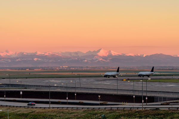
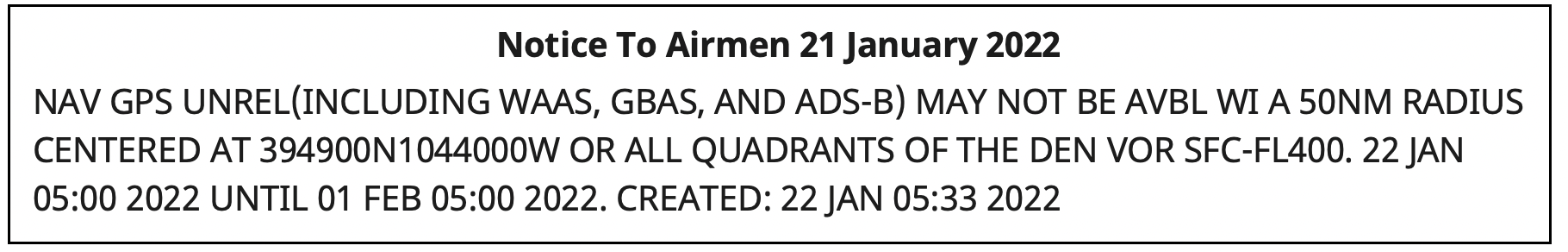
Something big happened to GPS service in the Denver area on Jan. 21.
On that day, Air Traffic Control issued a notice advising pilots of problems with GPS reception spanning about 8,000 square miles in the Denver area.
The advisory, posted at 10:33 p.m. Denver time, said GPS was unreliable within a 50-nautical-mile radius of the Denver International Airport. Interference was likely to be experienced by aircraft on the ground and as high as 40,000 feet above sea level.
The advisory also said the Wide Area Augmentation System (WAAS) and Ground-Based Augmentation System (GBAS), both designed to make navigation with GPS more precise, as well as the ADS-B collision avoidance and traffic management system, would be unreliable.
Pilots reported other systems affected such as transponders that help radar controllers keep track of aircraft, traffic alert and collision avoidance (TCAS) equipment, autopilots, electronic flight bags and terrain warning systems.
Pilots trying to land at Denver International and the much small Centennial Airport 20 miles to the south reported a variety of problems.
I flew in there (Centennial Airport) last night and I’m about to fly out. One second everything was fine, and then next second we completely lost GPS for the rest of the flight, probably coming through ~14,000 [feet] on the arrival from the northwest.
In addition to verbal reports to air traffic controllers, formal reports were filed with NASA’s Aviation Safety Reporting System (ASRS) by pilots flying into Denver International. (Note that ASRS only lists the month reports were submitted, not the day, to preserve anonymity.) Nineteen ASRS reports about GPS in Denver during January match well with comments on Reddit and an Airliners.net forum for the 21st and 22nd of the month.
The ASRS reports tended to focus on problems during approaches to the airport and landings. The most minor included distracting cockpit alerts and warnings.
Cleared ECAM (Electronic Centralized Aircraft Monitor) and emergency cancelled the repetitive nuisance messages. Additionally, received a GPS Lost message on FMC [Flight Management Computer].
More concerning were incidents that could more directly impact safety of flight.
One aircraft’s collision avoidance system, which normally reports issues as they develop, abruptly directed action to avoid another aircraft.
…we received a “LEVEL OFF” TCAS RA with no prior notification. The offending target was to our 2-3 o’clock and climbing…
Two aircraft reported confusing navigation displays on final approach to the airport. One pilot flying in limited visibility (instrument conditions) was sufficiently concerned that they aborted a landing attempt at the last minute.
We were about 1000 AGL [1,000 ft above ground level] – not sure about the exact altitude – and our RA [anti-collision warning] turned into an amber color… We were about 300 – 200 AGL and our autopilot failed… It was very unexpected… I called the go-around.
So, what happened to GPS?
At first, Air Traffic Control told pilots 5G telecommunications systems were causing the interference. That stopped at some point, though, according to an online comment:
As a [air traffic] controller… they haven’t told us anything. I was at work when it all started yesterday and they told us to make broadcasts about 5G interference. Today, they said it wasn’t 5G and not to make those broadcasts, but they still haven’t said what the issue is. There’s obviously rumors and speculation, but at this point, nothing concrete.
The first mention of the incident in traditional media seems to have been in an August 2022 journal article by a group of researchers at Stanford University. It focused on using the aviation ADS-B system to geo-locate GPS interference. The U.S. Department of Transportation provided the exact location and signal strength of Denver’s interfering transmitter to assist the Stanford study.
Requests in August and early September to the departments of Transportation, Homeland Security and Defense for more information on the incident went unanswered.
Mike Roskind from the Department of Homeland Security (DHS) provided some information and promised a formal report would be forthcoming. He said:
the incident lasted for 33.5 hours
impacts varied across infrastructures and applications; some users who were physically shielded from the interference source were able to maintain service
wireline and cellular providers had timing backup systems and were unaffected
a radio system with no backups suffered, as did a simulcast radio system that used rubidium backup clocks; the clocks drifted away from each other over the course of the outage and caused towers to isolate.
Responding to a question about the source of the interference, Roskind confirmed that 5G telecommunication was not the cause, but refused to say more.
He also declined to identify other systems, applications and infrastructure impacted by the disruption. He said that the department is very concerned about protecting the identity of affected users cooperating with the government analysis.
More information will be provided in a DHS report on the incident titled “GPS Interference Happens.” The report is in final review now, according to Roskind, and is expected to be released in October.
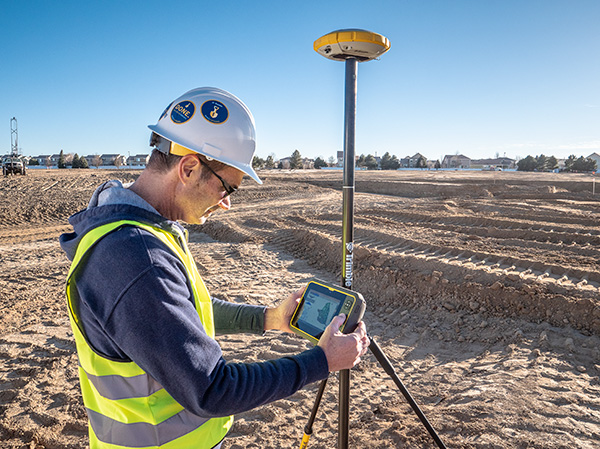
The University of Colorado – Denver has received a significant gift from Trimble to establish a state-of-the-art technology lab for the College of Engineering, Design and Computing.
The gift will also support the departments or programs in construction engineering and construction management, geography and environmental sciences, physics, and urban and regional planning. The lab will expand the university’s access and expertise in a customized suite of construction hardware and software products.
Trimble’s broad Connected Construction portfolio enables professionals along the project lifecycle to accelerate project processes — improving productivity, quality, transparency, safety and sustainability, while reducing waste.
The Trimble Technology Lab will provide students enrolled across relevant programs hands-on experience with a wide breadth of Trimble solutions. The lab will expand the university’s access and expertise in project management, architectural and structural analysis, design and engineering, mixed reality, 3D scanning, office-to-field solutions, and GIS data collection and GNSS positioning.
Partnering with Trimble allows the University of Colorado – Denver to integrate the latest technology into its curricula, empowering graduates to rapidly transform how buildings and living environments are designed and constructed.
The lab will include a broad range of Trimble’s technologies.
Hardware includes the Trimble XR10 HoloLens with hardhat, TX8 3D laser scanner, Trimble SiteVision AR system, R12 GNSS systems, Juno 5D handheld scanner, Geo 7x mobile GNSS data collectors, robotic total stations and field tablets.
Software solutions include RealWorks scanning software, Trimble Business Center, Tekla Structures, Tekla Structural Designer, Tekla Tedds, Trimble Connect, ProjectSight, Viewpoint, TILOS, Trimble Positions Desktop, TerraSync and TerraFlex, eCognition, and the company’s 3D modeling software, SketchUp Pro.
“CU Denver is right in our backyard, providing an exciting opportunity to integrate our industry-leading technologies into a wide range of educational programs. Their proximity enables us to work closely while ensuring easy access, training and support, and success in all aspects of implementation,” said Allyson McDuffie, director of Education & Outreach at Trimble. “Trimble’s education and outreach programs aim to support the next generation of influencers by actively working with key education institutions to ensure Trimble’s portfolio of solutions are accessible and implemented in higher education curricula and research programs, creating a new workforce equipped and empowered to ‘Transform the Way the World Works.’”
Martin Dunn, dean of the College of Engineering, Design and Computing, said, “I am thrilled with and grateful for this exciting relationship with Trimble. It will accelerate our strategic vision to educate diverse graduates who will not only make an immediate impact in the AEC industry, but will emerge as its future leaders. The generous gift will have broad impact across our campus, nucleating the kind of interdisciplinary collaboration among engineers, architects, construction managers, and scientists that is needed to create and exploit technological innovation to address grand challenges facing the built environment including digital transformation, sustainability, and the future of work and the workforce.”
“Our students and faculty could not be more excited to have access to Trimble technologies. Trimble is a company of international importance, which is also right down the road from our campus. In establishing this new lab, our students will be exposed, either virtually or on-site, to cutting edge products and innovation as well as benefit from direct access to the many professionals in Trimble’s worldwide network. Trimble is exactly the type of company that gets our students excited about pursuing careers in construction and engineering,” said Caroline Clevenger, associate professor and director of Construction Engineering and Management.
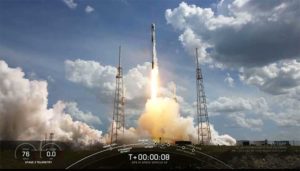
Third Lockheed Martin-Built GPS III satellite climbs to orbit on its own power
GPS III SV03 increases number of secure military code (M-code) enabled satellites in GPS constellation to 22 total.
After a successful launch on June 30, the third Lockheed Martin-built GPS III satellite headed to orbit under its own propulsion. The satellite separated from its rocket and used onboard power to climb to its operational orbit, approximately 12,550 miles above the Earth.
GPS III Space Vehicle 03 is responding to commands from U.S. Space Force and Lockheed Martin engineers in the Launch & Checkout Center at the company’s Denver facility. There, they declared rocket booster separation and satellite control about 90 minutes after the satellite’s June 30 launch aboard a SpaceX Falcon 9 rocket from Cape Canaveral Air Force Station, Florida.
“In the coming days, GPS III SV03’s onboard liquid apogee engines will continue to propel the satellite towards its operational orbit,” said Tonya Ladwig, Lockheed Martin’s acting vice president for Navigation Systems. “Once it arrives, we’ll send the satellite commands to deploy its solar arrays and antennas, and prepare the satellite for handover to Space Operations Command.”
After on-orbit testing, GPS III SV03 is expected to join the GPS constellation — including GPS III SV01 and SV02, which were declared operational in January and April — in providing positioning, navigation and timing signals for more than four billion military, civil and commercial users.
Lockheed Martin designed GPS III to help the Space Force modernize the GPS constellation with new technology and capabilities. The new GPS IIIs provide three times better accuracy and up to eight times improved anti-jamming capabilities over any previous GPS satellite. They also offer a new L1C civil signal, which is compatible with other international global navigation satellite systems, like Europe’s Galileo, to improve civilian user connectivity.
GPS III also continues the Space Force’s plan to field M-code, a more-secure, harder-to-jam and spoof GPS signal for our military forces. GPS III SV03 brings the number of M-code enabled satellites to 22 in the 31-satellite GPS constellation.
“As a nation, we use GPS signals every day — they time-stamp all our financial transactions, they make aviation safe, they make precision farming possible, and so much more,” added Ladwig. “GPS has become a critical part of our national infrastructure. In fact, the U.S. economic benefit of GPS is estimated to be over $300 billion per year and $1.4 trillion since its inception. Continued investment in modernizing GPS — updating technology, improving its capabilities — is well worth it.”
Click on the icon in the top left hand corner to choose the video you’d like to watch.
The GPS World and Geospatial Solutions staff reported live from the Association for Unmanned Vehicle Systems International’s (AUVSI’s) Xponential 2018 April 30-May 3 in Denver. Check out videos from the event above.
ILMF is a technical conference and exhibition showcasing the latest airborne, terrestrial and underwater lidar, as well as emerging remote-sensing and data collection tools and technologies.
According to organizers, the show will allow attendees and exhibitors to connect with hundreds of professionals seeking lidar and other 3D geospatial data collection technologies to support asset management, civil infrastructure, coastal zone mapping, emergency services and disaster response, land and natural resource management, urban modeling and more. It will also cover the latest advances in lidar technology.
Keynote speakers at the event will include the U.S. Geological Survey’s Jeff Sloan, who will discuss if data from UAS sensors will overtake manned and satellite sources; Colorado State University’s Michael Lefsky, who will discuss reconstructing historic land use and forest structure using aerial photos and structure from motion analysis; and the NASA Jet Propulsion Laboratory’s Eric Larour, who will address a new tool from NASA for coastal planners.
ILMF will be co-located with the ASPRS Annual Conference. The combined event will feature a single exhibit hall. The two events will still have their own technical programs, and attendees will have the option to purchase a conference pass for programs of their choice or a universal pass for all offered programs.
The event convenes the global community of commercial and defense leaders in intelligent robotics, drones and unmanned systems. Check out news, photos and videos from the show.