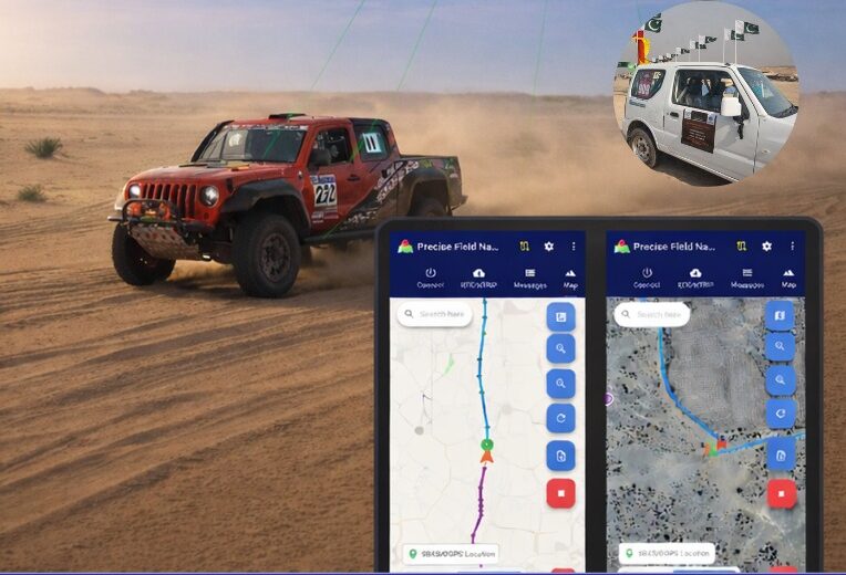
Pakistan’s national space agency SUPARCO (Space and Upper Atmosphere Research Commission) has achieved a major milestone in navigation technology with the successful launch of its Pak-SBAS satellite-based augmentation system (SBAS) device and service.
The Pak-SBAS navigation service was rigorously tested in the extreme desert conditions of Cholistan during Cholistan Desert Rally 2026. The Cholistan desert experinces high speeds, unpredictable routes, and the absence of visual landmarks that demand exceptional positioning accuracy and signal reliability for autos and motorcycles.
Throughout the rally, Pak-SBAS demonstrated remarkable performance by delivering highly precise location data, stable signal continuity, and integrated route tracking.
By applying SBAS corrections, the system significantly reduced positioning errors compared to conventional GNSS technologies, offering rally drivers and navigation teams a new level of confidence essential for competitive desert racing.
According to a SUPARCO spokesperson, the Pak-SBAS technology holds vast potential beyond motorsports. It is expected to enhance disaster response operations through accurate tracking of rescue teams and affected areas, improve transport efficiency via real-time vehicle positioning, and strengthen aviation safety with more reliable navigation support.
The system also will benefit the surveying and mapping sectors by minimizing positional inaccuracies and reducing project costs.
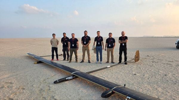
UAVOS has successfully completed of a test flight of Mira Aerospace’s high-altitude pseudo-satellite (HAPS) ApusNeo 18, with UAVOS providing full engineering and technical support. A key objective of the flight was to evaluate the jointly developed optoelectronic, gyro-stabilized aircraft payload onboard device (POD) by obtaining imagery from altitudes between 3,000 and 12,000 meters.
During the mission, the POD captured high-resolution imagery with precise geolocation data from an altitude of 12,000 meters, achieving a Ground Sample Distance (GSD) of up to two meters. The test took place in Abu Dhabi, UAE, and lasted continuously for 48 hours.
“The data-relay station trials were conducted in preparation for upcoming commercial flights in Europe, planned for the coming months,” Aliaksei said.
The optoelectronic gyro-stabilized aircraft POD is equipped with an innovative automatic temperature control system for heating and cooling electronic modules, ensuring reliable operation in the stratosphere at temperatures as low as -70°C under rarefied air conditions.
The system also provides radio communication at distances exceeding 100 km. The gimbal’s optical unit allows observation within a ±90°C range with high-precision angular positioning. The payload housing features an aerodynamically optimized design, and the total payload weight is 3.6 kg.
“The successful cooperation with Mira Aerospace reflects our commitment to continuously advancing the capabilities of both companies,” said Aliaksei Stratsilatau, founder and CEO of UAVOS. “We also continue to work toward our ultimate goal of leveraging the HAPS platform for multiple applications, including mobile connectivity, border monitoring, mapping, forest fire detection, and emergency response.”
To extend the HAPS operational range, the test flight also incorporated a data-relay network based on ground modem repeaters. Each repeater is capable of providing a coverage area of up to 200 km.
“The data-relay station trials were conducted in preparation for upcoming commercial flights in Europe, planned for the coming months,” Aliaksei said.
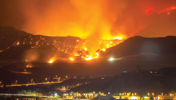
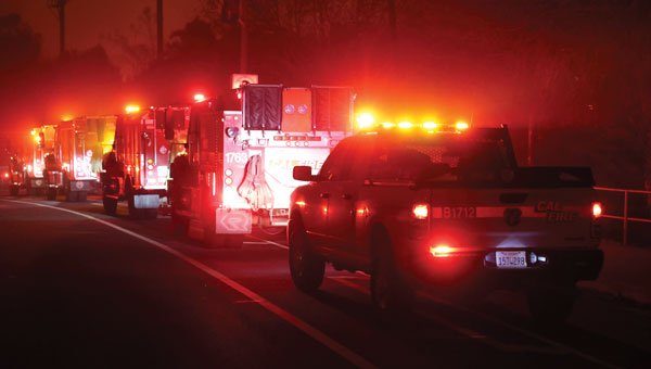
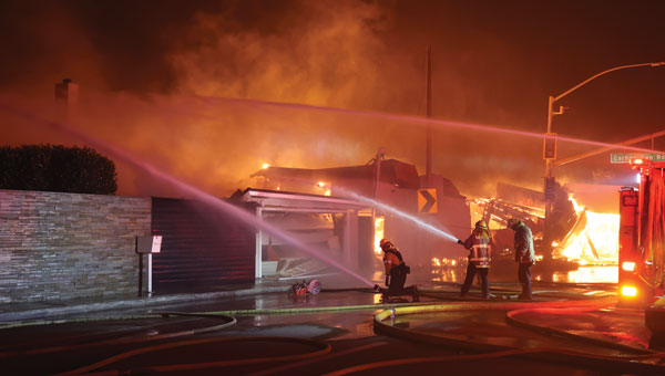
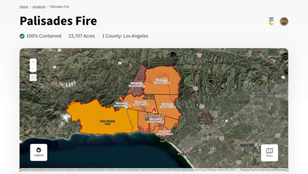
The Palisades and Eaton fires devastated parts of Los Angeles in January 2025 and are largely contained as of Jan. 20. Fueled by extreme Santa Ana winds and dry conditions, these fires have left a mark on the region’s landscape and community.
The Palisades Fire, which originated in the Pacific Palisades on Jan. 7, ultimately burned 23,448 acres, resulted in 12 confirmed fatalities and destroyed or damaged more than 6,800 structures, according to the California Department of Forestry and Fire Protection, known as CAL FIRE. The fire’s rapid expansion was particularly alarming, growing from a small brush fire to a massive conflagration within an hour.
Simultaneously, the Eaton Fire, which began near Altadena and Pasadena, consumed 14,117 acres. This fire proved even more deadly, with 17 confirmed fatalities and significant damage to more than 10,000 structures, according to CAL FIRE. Both the Palisades and Eaton fires have now been classified among the most destructive wildfires in California’s history.
During times of emergency, geographic information systems (GIS) specialists come together to create real-time mapping tools to provide critical support to first responders and keep communities well-informed. These tools have become indispensable in modern disaster management, particularly in wildfire response.
Interactive 3D Maps
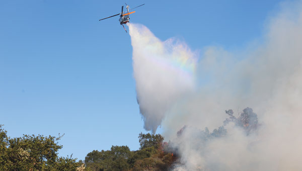
Firefighters and other specialists from federal, state, and local agencies work together to fight wildfires. GIS specialists develop interactive 3D maps to display fire perimeters, evacuation zones and other critical data. The geospatial data serves as the foundation for effective communication and decision-making, allowing firefighters and incident management teams to access information in near real-time to make informed decisions.
Fire GIS specialists Peter Rowland, Brett Adler and Dawn Hutchinson shared insights into their teams’ strategies for wildfire management. They emphasize the crucial role of geospatial tools in disaster response by delivering actionable intelligence. GPS World interviewed them during the California wildfires. Rowland and Adler were based at the Palisades fire, while Hutchinson, who is a member of a California Interagency Incident Management Team (CIIMT), was located near the Eaton fire.
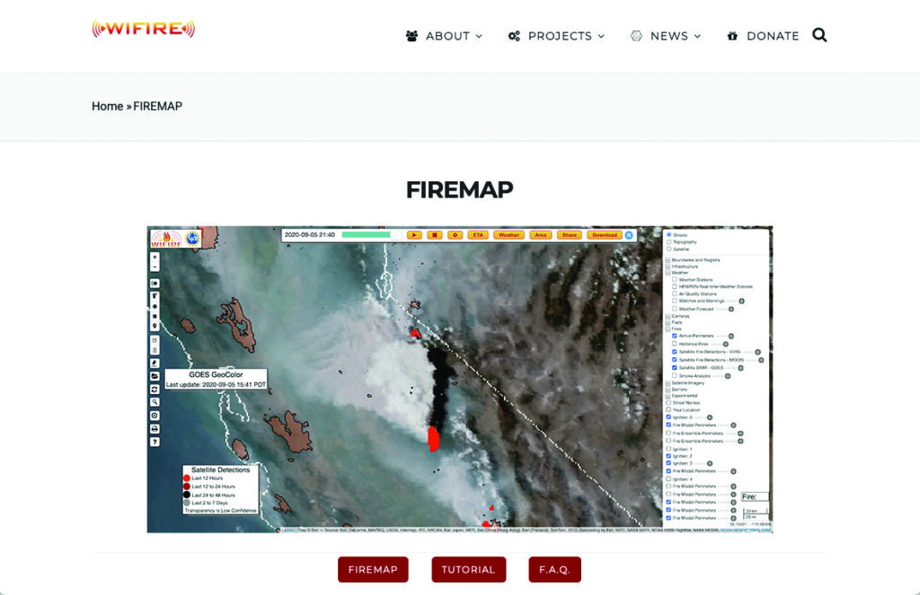
Interagency GIS teams use the Fire Integrated Real-Time Intelligence System (FIRIS) to watch for fire starts and then receive alerts from dispatch centers and satellite imagery. After locating the point of ignition, they create fire behavior models using a program called WIFIRE from UC San Diego. This tool allows them to predict the fire’s probable trajectory and size.
Photo: CAL FIRE
The team will alert the state if the data shows the fire is likely to spread. Hutchinson explains that, within minutes of the start of the Eaton fire, her team produced a fire behavior model that illustrated where the fire was most likely to go and how big it would likely get within the next three hours.
Photo: CAL FIRE
The frequency of IR flights depends on the fire’s size and intensity. Occurring anywhere from once to three times daily, including nighttime, these flights comprehensively map the landscape based on the fire’s specific traits. The decision on how often to fly the planes and collect the IR data depends on the fire’s behavior and potential threat level.
Field observers are also deployed daily to collect data down to the debris. They walk the fire’s edge and move along specific paths created for wildfire management and containment. Once a fire is contained, GIS specialists try to verify ground truth for the perimeter of the entire fire.
GIS specialists constantly update fire perimeters as they get data from the field and the planes. Once a fire is contained, they create final maps to hand over to the local agencies or the Forest Service.
Photo: CAL FIRE
Most of the data that GIS specialists use to map fires comes from field observers and infrared (IR) thermal imagery. The data is collected by third-party contractors, by CAL FIRE’s Intel shift team, or by the FIRIS program by flying manned aircraft.
IR data and information collected by field observers are then uploaded into the National Incident Feature Service (NIFS) for GIS specialists to use to map fires.
Field observers download the maps onto their devices, go out into the field, and ground truth — physically walking the perimeter of the fire and using GPS on their devices to map the fire boundaries accurately.
Photo: CAL FIRE
Paper maps are good to have “just to get everybody on the same page without having to worry about battery life or the glare while you’re working out in the field,” said Rowland.
Along with online maps, the Interagency GIS teams print PDF maps for fire personnel in the field. The field observers use Esri ArcGIS Field Maps to record their tracks. They pair their mobile devices with Avenza or other geolocating applications.
Using ArcGIS Pro, GIS specialists create online maps and dashboards, which are then distributed in print and/or digitally to the agencies that need them, such as sheriff and police departments and departments of public works. The Interagency GIS teams create different map products for different end users. For example, it works with law enforcement to create evacuation maps and zones. Local public information officers also can distribute these maps or post them on their websites.
Photo: CAL FIRE
Crews also have online access to the maps through wildfire FTP (ftp.wildfire.gov). Crews load data and maps there that contain public information. Many agencies plug into the National Interagency Fire Center (NIFC), where the CAL FIRE team edits and analyzes mobile data.
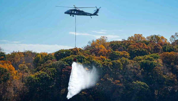
Sikorsky, a Lockheed Martin company, and Rain, a provider of autonomous aerial wildfire containment technology, successfully demonstrated how an autonomous Black Hawk helicopter can be commanded to take off, identify the location and size of a small fire and then accurately drop water to suppress the flames.
At Sikorsky headquarters in Stratford, Connecticut, the Rapid Wildfire Response Demonstration showcased the integration of Sikorsky’s MATRIX flight autonomy with Rain’s wildfire mission autonomy system to suppress a fire in its early stages.
Representatives from NASA, the Federal Emergency Management Agency (FEMA), the Defense Advanced Research Projects Agency (DARPA), the Los Angeles County Fire Department, the Orange County Fire Authority and the philanthropic and impact investment community witnessed the demonstration as part of a two-day wildlands firefighting meeting to discuss autonomy.
During the 30-minute flight demonstration, guests used a tablet to command the Black Hawk aircraft to take off, search for and find the fire and then drop water from a Bambi Bucket slung 60 ft beneath the aircraft. Each of three successive water drops extinguished a 12-inch-diameter propane-fueled fire ring emitting a 3-to-6-inch-tall flame, demonstrating the precision of the Rain fire perception and targeting capability. The Rain system also rapidly adjusted the flight path to account for an 8-to-10-knot crosswind during each water drop. Sikorsky safety pilots in the Black Hawk cockpit monitored the flight controls but were hands-off until the aircraft landed.
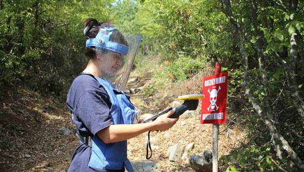
Trimble has expanded support for The HALO Trust, the world’s largest humanitarian landmine-clearance nonprofit organization. Trimble is donating an additional 175 Trimble Catalyst GNSS systems, including Trimble DA2 GNSS receivers, to help The HALO Trust further its demining operations worldwide.
Building on the impact of the ongoing collaboration, Trimble’s latest donation will support the expansion and productivity of The HALO Trust’s mine clearance teams. The Catalyst GNSS system provides The HALO Trust with a solution for deploying precise mapping capabilities to large field teams across broad geographic areas. More field teams can now be equipped with the necessary tools to safely and efficiently clear landmines, thereby accelerating the pace of landmine clearance globally.
Since receiving Trimble’s product donations and the Trimble Foundation Fund-directed grant, The HALO Trust has made significant progress in landmine and unexploded ordnance (UXO) clearance. From January to September 2024 alone, The HALO Trust cleared 802 minefields and battlefields, covering a total area of 10,400 acres across 12 war-torn countries. During this period, 31,209 landmines and other Explosive Remnants of War (ERW) were safely destroyed — all accurately mapped using the Trimble Catalyst GNSS system. The HALO Trust’s use of Trimble technology has significantly improved operational efficiency and provided essential data for safe land reclamation and development. According to The HALO Trust, the accuracy and reliability of Trimble’s technology have been crucial in ensuring the safety and success of demining operations in areas severely affected by conflict, such as Ukraine, Angola and Sri Lanka.
Thales Alenia Space, along with Viettel and MKE, have been selected by Vinamarine to provide Vietnam with a MEOLUT Next ground station. MEOLUT Next will operate as a part of the COSPAS-SARSAT global medium orbit search-and-rescue (SAR) network.
The SAR solution will enable the detection and location of distress signals from COSPAS-SARSAT beacons on land, in the air, and at sea over a radius of 2,500 km around Haiphong, Vietnam, mainly using signals from Galileo.
Thales Alenia Space’s MEOLUT Next solution employs a phased array antenna and can track more than 30 satellites, which enhances distress beacon detection and expands coverage. The solution can detect and locate distress signals from more than 5,000 km away.
MEOLUT Next is used by other COSPAS-SARSAT users including Canada, the United States, France, the European Union, Togo and Thailand.
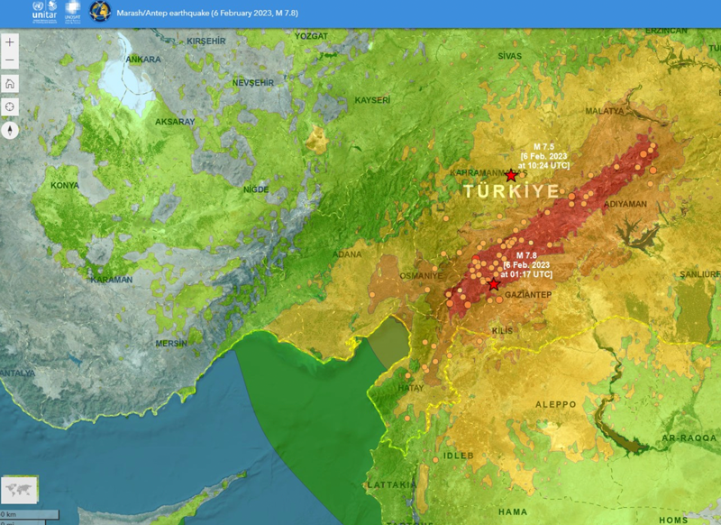
On Feb. 6, a magnitude 7.8 earthquake struck Turkiye and northern Syria creating enormous damage throughout both countries. (Image: mustafaoncul/iStock /Getty Images Plus/Getty Images)
Geographical information of urban areas is critical because it forms the basis for planning, intelligent urban modeling and disaster mapping and management. For many decades, ground surveys and aerial photographs were used as the primary tools for collecting this data. Starting in the 1990s, these methods were replaced by such advanced remote-sensing technologies as synthetic aperture radar (SAR) and ground-based interferometric radar (GBIR).
This article explores the use of software-defined radio (SDR) platforms for acquiring high-resolution SAR/GBIR images, including:
How low-cost commercial-off-the-shelf SDR platforms can be used to realize complex systems for acquiring images and processing measurements.
How different specifications of SDRs make them suitable for use in SAR applications.
Hazard Monitoring in Urban Areas
Many urban areas and critical infrastructure are in regions highly prone to natural disasters such as volcano eruptions, earthquakes, avalanches and landslides, or near man-made systems such as dams and quarries. Monitoring of surface changes and structures is integral to the mitigation of risk and ensuring public safety. Modern remote-monitoring systems allow surface displacements to be monitored without the need to access a location. With these systems, several square kilometers of Earth’s surface can be monitored at once and with high accuracy. The sub-millimeter accuracy of modern remote-monitoring technologies enables accurate measurements to be collected with impressive precision, including in rainy and foggy conditions.
Remote-monitoring systems are autonomous and can operate for a long time without human intervention. Their real-time feedback makes them suitable for use as early-warning systems. In addition, these monitoring systems can be integrated into a wide range of sub-systems, such as decision support systems that assist decision makers in assessing emergency plans and selecting the best options.
Using Radar to Measure
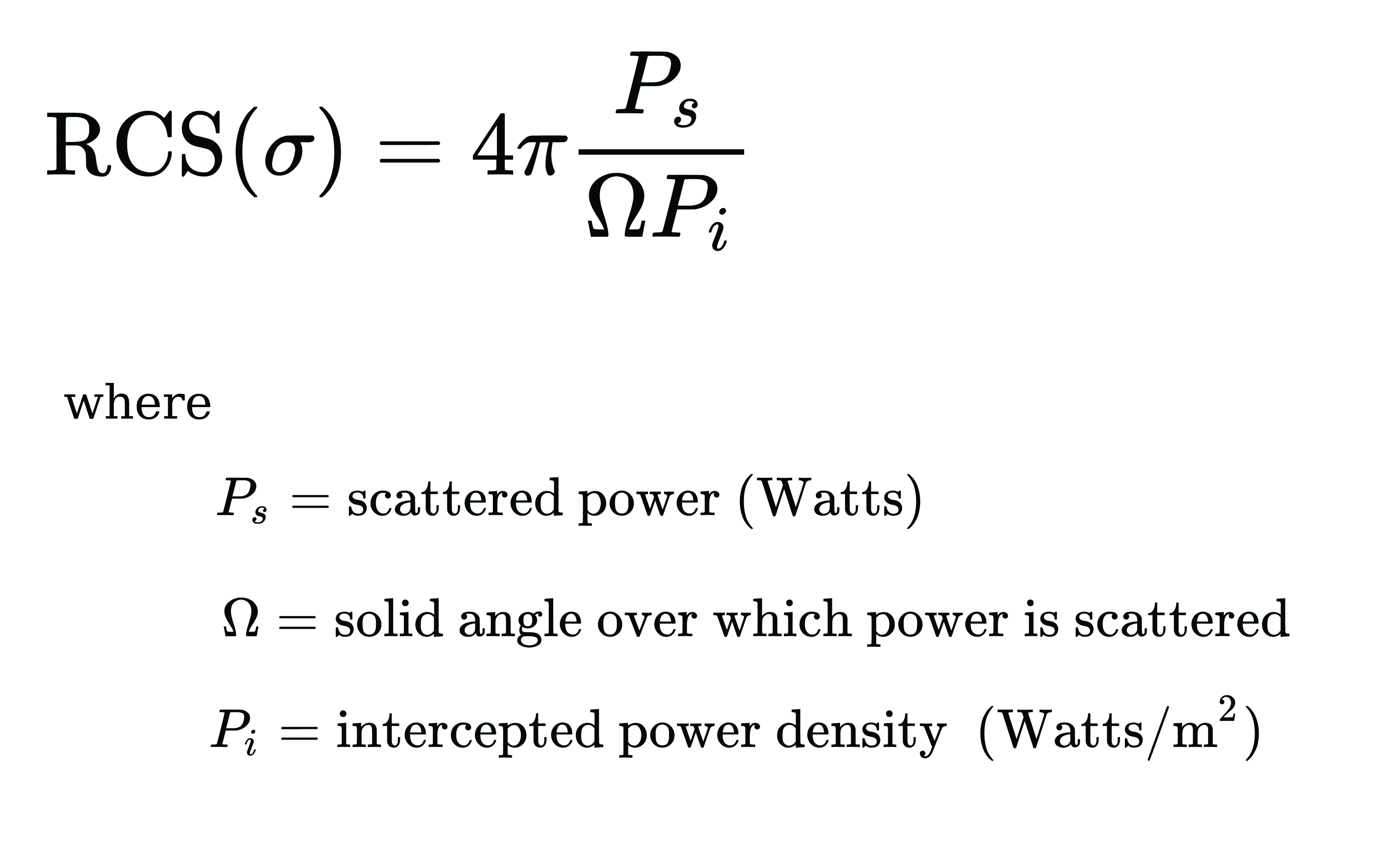
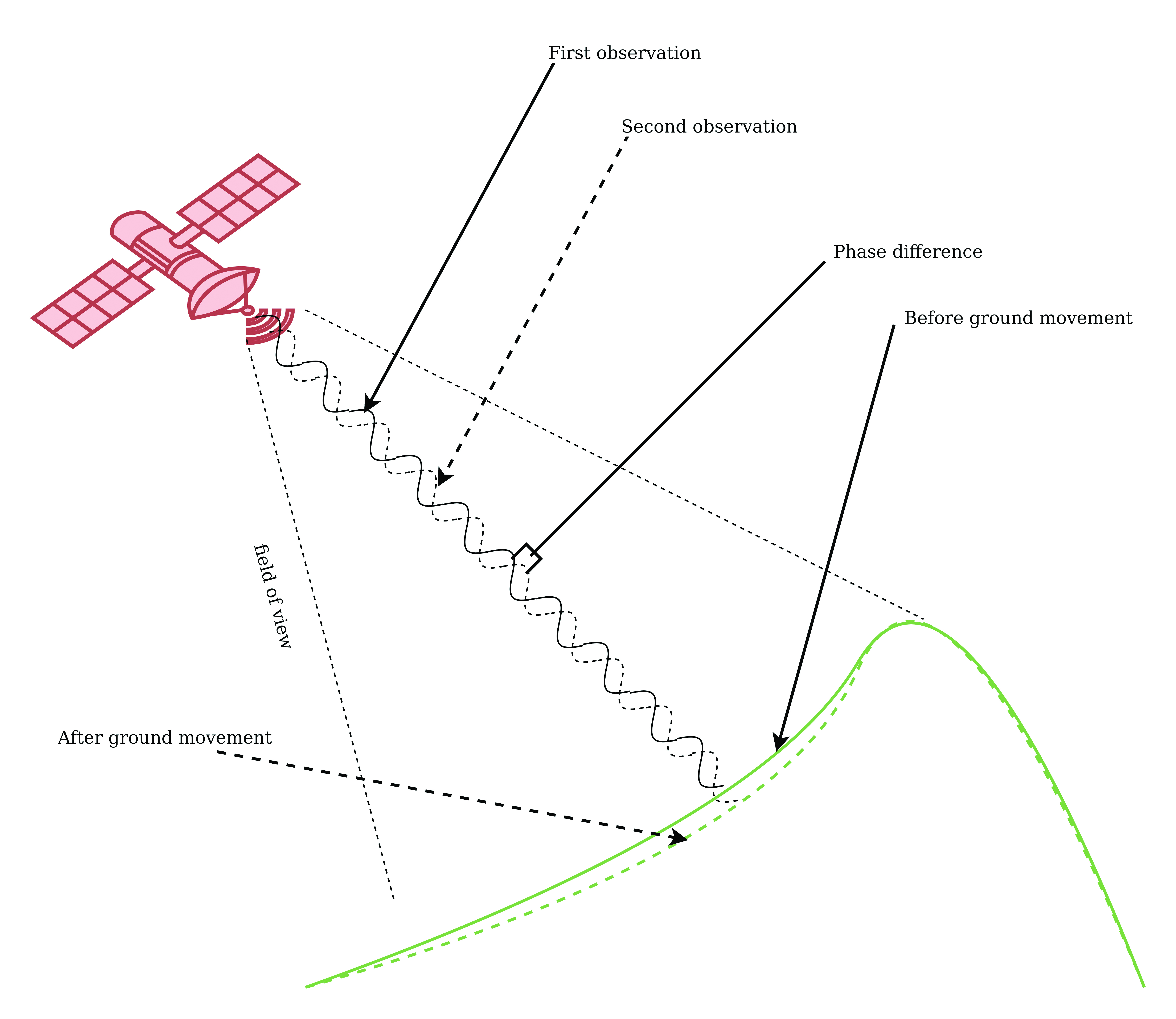
Details of the surface observed by a SAR satellite are encoded in the amplitude and phase of a SAR image. The amplitude component contains information about the surface roughness and terrain slope of the target area, while the phase component contains information about the elevation of the satellite.
A typical SAR satellite transmits microwave signals toward a target area at an oblique angle and measures the backscattered signal. The intensity of the reflected signal is mainly determined by the roughness and the structure of the target, and the distance between the satellite and the target. This measurement is usually described in terms of the radar cross-section (RCS) parameter, which is obtained by calculating the ratio of the scattered to the intercepted signals as shown in this equation:
The RCS parameter is mainly dependent on the surface roughness and the dielectric properties of the target object.
The interferometric SAR (InSAR) technique allows surface movements to be identified. These observations also can be used to measure and monitor changes associated with volcanic eruptions, tectonic activity and other geophysical processes. To identify crustal changes using this geodetic technique, at least two SAR images are required.
Figure 1. Phase shift in InSAR observations due to ground movement. (Image: Simon Ndiritu)
In differential InSAR, two images of the same location that are recorded at different times are used. If a surface movement has occurred between the first and the second acquisition, a phase shift is observed (Figure 1). The presence of interference fringes on an interferogram is an indicator of a phase shift and these fringes are summed during processing to provide a relative value of the phase change.
Ground-based SAR (GBSAR) employs the synthetic aperture radar technique to capture high-resolution images of the electromagnetic reflectivity of a target. This remote-sensing system is commonly used for monitoring civil infrastructure, buildings, mines, landslides, glaciers and more. While spaceborne SAR is capable of surveying large areas and records data over long periods of time, usually several weeks or months, GBSAR is suitable for monitoring small areas and has short sampling periods, usually a few minutes. In most surveying applications, the two remote-monitoring techniques are used together in a complementary fashion to enhance the overall performance.
The all-weather monitoring capability of satellite-based SAR makes it a popular tool for natural disaster management. Since the launch of the first SAR satellite in 1991, this technology has provided many emergency response teams with important insights on manmade and natural hazards. SAR data can be used to study different aspects of long-term behaviors of slow-moving surfaces, which is critical for planning emergency response to natural hazards such as volcanic eruptions, landslides and avalanches. SAR satellites orbit Earth at altitudes of between 500 km and 800 km and operate in the C-band (5 GHz to 6 GHz), X-band (8 GHz to 12 GHz) and L-band (1 GHz to 2 GHz). The temporal resolution of these satellites is mainly determined by their revisit periods.
Software-Defined Radio Platforms
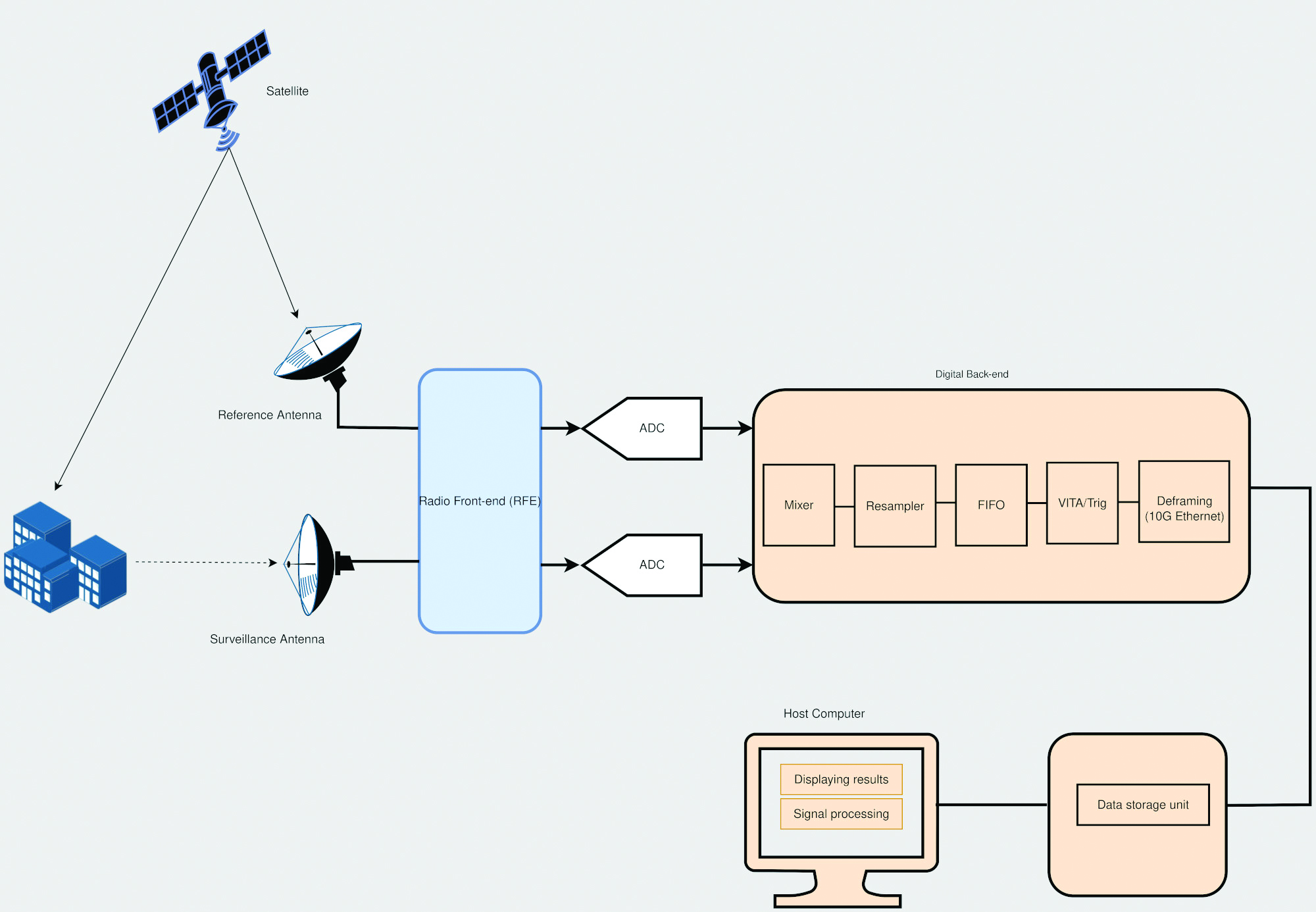
A typical SDR platform features a radio front end (RFE) and a digital back end, with the RFE performing receive (Rx) and transmit (Tx) functions and offering a wide tuning range, typically 0 GHz to 18 GHz. This range is acceptable for widely used bands in SAR applications, including L-band, C-band and X-band.
The digital back end of a high-performance SDR system features a field programmable gate array (FPGA). This FPGA offers a variety of digital signal processing (DSP) capabilities, including upconverting, downconverting, modulation and demodulation. In addition, an SDR platform offers multiple transmit and receive channels, making it suitable for implementing multi-in multi-out (MIMO) radar systems.
The architecture of SDR platforms allows them to integrate easily with a wide range of complex systems, such as SAR systems. The reconfigurability of SDRs allows upgrades and updates to be implemented without modifying the existing hardware, and can be designed to meet the size, weight and power (SWaP) requirements of an application. These features make SDRs suitable for implementing custom SAR monitoring solutions in small and large ground stations (Figure 2).
Figure 2. A simplified diagram of an SDR-based SAR system is shown, which employs a mobile-transmitter fixed-receiver passive bistatic SAR (MF-PB-SAR) architecture. (Image: Simon Ndiritu)
Integrating SDRs with SAR
A software-defined radar (SDRadar) is an SDR-based radar system that offers high flexibility and robustness. Compared to conventional radar, SDRadar offers many benefits, including the opportunity to reuse hardware, develop multi-function radar solutions, achieve faster development cycles, and have easier implementation of updates and new algorithms.
Tests with prototype SDR-based GBSAR systems have revealed the strong potential of SDR-based implementations. The MIMO architecture of an SDR platform allows realization of complex multi-frequency GBSAR systems uniquely suited for measuring displacement and other geophysical characteristics of landforms. SDR-based GBSAR systems can operate in different frequency bands and offer unmatched flexibility when it comes to signal generation and digital signal processing.
Many prototypes of airborne/satellite SAR systems based on SDR platforms have been implemented and their performance evaluated. Results have shown that they can offer better performance compared to conventional implementations. The use of multiple independent channels by SDR platforms allows the realization of compact and power-efficient multimode SAR systems, while the architecture of an SDR platform allows complex signal processing techniques such as digital beamforming (DBF), null steering and direction of arrival estimation to be implemented on FPGA.
Benefits of Integrating SDRs with SAR Solutions
Integrating SDRs into SAR systems provides many benefits. The MIMO architecture of SDR systems provides more channels than are required for SAR functions. The extra channels can be used for other applications such as satellite communications during emergencies. The wide frequency-tuning range of an SDR system allows the realization of a multi-function system with applications using different frequency bands. The reconfigurability of SDR platforms allows them to be repurposed for other applications. In addition, this reconfigurability enhances reusability, scalability and power efficiency. The low-latency FPGAs in high-performance SDR systems allow the realization of ultra-high-speed DSP algorithms for use in image processing and DBF.
Conclusion
The reconfigurability and impressive performance features of SDR platforms make them ideal for implementing scalable and flexible SAR monitoring systems for measuring land changes. The wide tuning range and MIMO architecture of SDR devices allows realization of a multi-function and multi-frequency system using a single device. In addition, the reconfigurability of SDR devices allows hardware reuse and low-cost implementation of updates and new algorithms.
Brendon McHugh is the field application engineer and technical writer at Per Vices. He possesses a degree in theoretical and mathematical physics from the University of Toronto.
Simon Ndiritu is an independent technical writer for Per Vices with a background in electrical and electronic engineer with a wealth of experience in designing hardware and firmware. He also has a passion for writing.
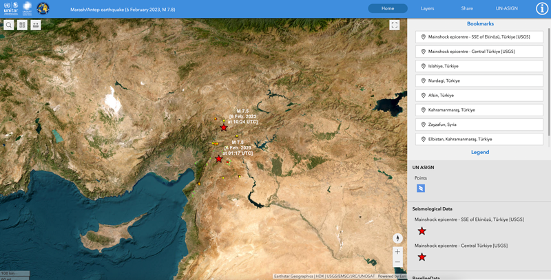
On Feb. 6, the United Nations Satellite Center (UNOSAT) announced via Twitter that it had activated emergency mapping services of Turkiye and northern Syria after the magnitude 7.8 earthquake hit earlier that day. The satellite images provide an overview of the damage, which can be used for humanitarian efforts and disaster relief, reported Space.com.
UNOSAT provides emergency mapping services, upon request, to provide satellite imagery analysis during emergencies and disasters. The maps show infrastructure that has been damaged during an emergency, which can then be used to provide relief by disaster response groups.
The impact of the earthquakes was significant and ranks in the red for economic losses and orange for fatalities, according to the U.S. Geological Survey (USGS). (Image: UNOSAT)
The earthquake caused massive destruction throughout Turkiye and Northern Syria, causing an estimated death toll of more than 19,000 as of Feb. 9. Several historical structures dating back thousands of years have also been severely damaged.
UNOSAT started in 2001 and is hosted by the European Organization for Nuclear Research. It does not operate its own satellites, but coordinates with United Nations member states to gather imagery from government agencies and privately owned satellites. United Nations offices, government agencies and relief organizations can request access to imagery collected by UNOSAT.
The USGS reports the earthquake resulted from strike-slip faulting at shallow depths. It appears to be associated with either the East Anatolia fault zone or the Dead Sea transform fault zone. (Image: UNOSAT)
All maps of Turkey and northern Syria from UNOSAT can be found here. A live interactive map can be found here.
The U.S. Department of Transportation’s Federal Aviation Administration (FAA) has awarded $2.7 million to support research on how drones can assist in disaster preparedness and in emergencies.
“Every second counts in an emergency, and this funding will allow drones to safely and more quickly deploy in moments when minutes matter,” said Acting FAA Administrator Billy Nolen.
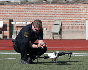
A policeman works with a drone. (Photo: FAA)Photo:
The research will explore the use of drones in providing effective and efficient responses to different natural and human-made disasters. It will address coordination procedures among drone operators from federal agencies as well as state and local disaster preparedness and emergency response organizations. The five universities and their award amounts are:
University of Vermont: $1,195,000
University of Alabama Huntsville: $828,070
New Mexico State University: $400,000
North Carolina State University: $200,000
Kansas State University: $145,000
Today’s announcement is the third round of Alliance for System Safety of UAS through Research Excellence (ASSURE) grants, which brings the total to 20 grants valued at $21 million for Fiscal Year 2022.
The ASSURE Center of Excellence is one of six the agency has established to help advance technology and educate the next generation of aviation professionals. Research conducted through ASSURE is focused on helping the drone community safely grow and integrate into the nation’s airspace.
Earlier in 2022, Transportation Secretary Pete Buttigieg outlined six key Innovation Principles the department will apply when fostering transportation technologies. While continuing to commit to the highest standards of safety across technologies, these awards demonstrate the department’s commitment to exploring ways to leverage innovation to help communities and public-sector partners through experimentation.
More than 850,000 recreational and commercial drones are in the active drone fleet, and that number is expected to grow.
Tenacity of spirit is one of the great virtues. Supporters of geospatial technology have often had to endure steadfast resolve convincing others of the multi-dimensional value GIS provides. It is a battle best won by seeing and doing rather than by words.
Then, in the early 2000s, due in large part to 9/11, the government’s interest in GIS increased.
It was a necessary evolution. Technologies at the time were rapidly advancing. Computer graphics, computer processing power, the internet, shared databases, GPS, digital imagery, and mobile devices needed to merge. GIS was the only solution to bring them all together.
At the same time, disasters became increasingly destructive. Public safety and emergency management needed solutions, but most of the funding is by the government with tight budgets, so investments into geospatial technologies and specialized staff were limited.
A small group of individuals saw that gap and together they began providing support to the public safety sector. The first organization they were able to work with was the National Association of State Fire Marshalls. Word quickly spread. Soon, other organizations began asking for geospatial services.
Eventually, 11 national organizations came together to provide support, structure and purpose for the fledgling team of GIS volunteers. This group became the founders of the National Alliance for Public Safety GIS (NAPSG) Foundation.
Now, 15 years later, NAPSG has contributed to recovery after every major disaster and many minor ones throughout the United States. Its success extends internationally — NAPSG has helped other countries set up their own public safety GIS support teams.
Image: NAPSG
Membership in NAPSG has grown to more than 65,000. Its members are involved in supporting operations for fires, flooding, search and rescue, earthquakes, storm and tornado damage, health crises, chemical spills, and more. They have become central to emergency management operations, helping coordinate efforts of multiple groups through GIS platforms.
During and after events, NAPSG hosts debriefs to evaluate and improve ongoing and future operations. The result advances the field of public safety. NAPSG also provides education to its constituent communities and makes its training available to the public.
NAPSG and its members are highly valued. Every state GIS council has the group as a point of contact. NAPSG is a trusted entity at the community level up through to the highest levels of the federal government, and they are one of the first calls FEMA makes in a crisis.
Tari Martin
I had the opportunity to interview Tari Martin (GISP), the director of national and federal programs, one of the leaders in NAPSG. Speaking with Tari made me realize that GIS is still early in its adoption phase. Tari is one of the founders of GIS at the state level. Earlier in her career she was the first person in the state of Maryland dedicated to supporting emergency management operations.
She helped build Maryland’s emergency management framework coordinated efforts with the National Incident Management System (NIMS), and she began pulling in federal data such as the Homeland Infrastructure Foundation-Level Dataset (HIFLD) for use in local operations.
Now, Tari serves on the Maryland GIS Council for the Public Safety/Next Generation 911 Subcommittee in addition to her regular duties as a director for NAPSG. Tari also serves as a program manager, working to create a universal symbology for public safety and emergency management.
Maps and map symbology are revered. Map symbology emerged from a long, proud, history of cartography dating back to a time before the Golden Age of Exploration when maps were adorned with beautiful, hand-drawn symbols of wind roses, sea creatures, and exotic plants and animals; including inscriptions, such as that within the cartouche of the Typus Orbis Terrarum (Atlas of the World) by Ortelius in 1573. Therein are inscribed the words from Cicero’s Tusculan Disputations, “Quid ei potest videri magnum in rebus humanis, cui aeternitas omnis, totiusque mundi nota sit magnitudo,” which translated means, “For what human affairs can seem important to a person who keeps all eternity before his eyes and knows the vastness of the universe?”
Map symbology has been more an art than a science driven predominantly to support specific purposes, such as navigation, war, surveying, mining, construction and recreation. Additionally, symbologies may not translate across professions, regions or cultures. Even when the symbols are the same, the colors may be different giving symbols different meanings.
Symbols are a visual language, and as the world becomes increasingly smaller and emergency events more international, the need for the language of maps to become universal is necessary. NAPSG has taken on that challenge, coordinating input from multiple stakeholders.
In essence, NAPSG is working with groups like Urban and Regional Information Systems Association (URISA) to create the Rosetta Stone of map symbology for public safety and emergency management, and Tari Martin is one of the central figures working on that project. The symbol library is free and publicly available on the NAPSG website.
Tari also reminisced about her early days when she first got into GIS just before Hurricane Katrina, and how many of her co-workers in Maryland mobilized to go down and help out with recovery operations. She stated that was one of the moments in her career that cemented her understanding for the value of GIS in post-disaster operations. Tari now teaches a course on GIS in Emergency Management for URISA.
NAPSG is involved in cutting-edge technologies helping to shape and educate the public safety community. Its members are working with autonomous vehicles, indoor mapping technologies, augmented reality and virtual reality, wearables, and other opportunities as they arise.
NAPSG makes its content available online. Explore its best practices, guidance and standards, education and training, events, qualifications and credentialing, toolkits and more. Become a NAPSG member at no cost.
William Tewelow works for the Federal Aviation Administration. He is a graduate of the FAA management fellowship program and while on special assignment to the U.S. Department of Transportation William led a national strategic geospatial project for the White House Open Data Partnership. He is a Geographic Information Systems Professional (GISP) and a Maryland STEMnet Scholar Speaker. He has degrees in Geographic Information Technology and Intelligence Studies, and is currently pursuing a masters degree in Organizational Management. He was among the first in the nation to earn a Geospatial Specialist Certification from the U.S. Department of Labor while working at NASA Stennis Space Center.
William retired from the U.S. Navy after serving 23 years as a Geospatial and Imagery Intelligence Specialist, a Naval Aviator, a Meteorologist, and a Tactical Oceanographer. He is married, enjoys writing, traveling, solving problems, and is fascinated by new technology and historical context. His favorite quote is, “A man’s mind changed by a new idea can never go back to its original dimension.” ~ Oliver Wendell Holmes
Communities in need of resources can access location intelligence technology at no cost with six-month trial
Location intelligence company Esri is making its software available to public and private sector organizations fighting the coronavirus (COVID-19) pandemic.
The COVID-19 outbreak has escalated rapidly across the globe, and with municipalities struggling to respond, Esri has built out resources to help organizations understand the potential impact of the disease on public health, as well as potential community risk areas and their capacity to respond.
A COVID-19 GIS Hub site provides much of this essential data, including case locations and social vulnerability, that communities and health organizations can use to inform their response.
To help public health agencies and other organizations jump-start their response, Esri is providing the ArcGIS Hub Coronavirus Response template at no cost through a complimentary six-month ArcGIS Online subscription with ArcGIS Hub. The template includes examples, materials, and configurations to rapidly deploy a local ArcGIS Hub environment. ArcGIS Hub is a framework to build a website to visualize and analyze the crisis in the context of an organization’s or community’s population and assets.
“Esri has always prioritized assisting communities during large-scale emergencies and natural disasters,” said Jack Dangermond, Esri founder and president. “For the past 25 years, our Disaster Response Program provides data, software, configurable applications, and technical support for emergency operations. We consider it part of our mission to provide these services free of cost during this time of national crisis.”
For more information on the complimentary software and the disaster relief support, visit esri.com/disaster.
Jeremy Kirkendall, senior GIS administrator for the NASA Disasters Program, gives GPS World an overview of the program at the 2019 Esri User Conference in San Diego. Watch this video to find out how satellite imagery produced by the program helps with disaster response efforts.