DJI’s M100 is designed for developers to test their applications.
UAV maker DJI has announced a suite of products designed to help developers research and test new applications for aerial technology. The company also announced the DJI Guidance system, a commercially available collision avoidance for aerial platforms.
The DJI Matrice 100 (M100) is a new quadcopter specifically created for developers to test new hardware and software solutions for the sky. The system includes everything needed to fly with minimal assembly time and no need for tuning or programming the platform to get it in the air.
With multiple communication ports, power supply leads, and expansion bays, peripheral hardware can be mounted to the system and access a flight data and control mechanisms. The platform can fly for 20 minutes with a 1kg (2.2 lbs) payload, but can be configured with an extra battery compartment to provide up to 40 minutes of flight time with a diminished payload capacity.
The M100 also incorporates DJI’s signature Lightbridge video transmission technology that is open to the DJI Inspire 1 Zenmuse X3 camera and gimbal, as well as any camera with HDMI or analogue video output. This makes it simpler than ever to stream live images to smart devices using DJI Pilot app from a variety of sensors, including near infrared and thermal.
“The M100 makes it easy to add processors, sensors and other equipment, opening the possibilities for how people use aerial technology in across industries,” said Frank Wang, CEO and CTO of DJI. “We’re excited to see how researchers and developers will use this platform to test how aerial technology can be used for agriculture, inspection, search and rescue and several other fields.”
Also announced is the DJI Guidance system, a commercially available collision avoidance for aerial platforms. Using a network of ultrasonic sensors and stereo cameras, Guidance identifies when an aerial platform is close to objects at a range up to 20m (65 feet) and will prevent flying close to the objects at a configurable distance, as well as providing centimetre visual positioning stabilization above the ground).
Guidance can mount to the DJI M100 or any other robotic system with USB and UART connection ports.
Both the M100 and Guidance system have software development kits (SDK) that allow developers to read flight data and control flight functions both through mobile applications and on board.
Research teams are already using the M100 and Guidance system for unique applications, including an aerial solution created at Fudan University in Shanghai that uses Intel processors to detect illegally parked cars from the air.
DJI also announced SDKs for the company’s leading aerial platforms, the DJI Inspire 1 and Phantom 3. The SDK for the Inspire 1 and Phantom 3 make it easy for software developers to create applications to control the world’s aerial imaging platforms.
“DJI has already made flight more accessible than ever before, but with our expanding developer suite we are making aerial innovation open to anyone with a creative vision,” said Andy Pan, DJI’s vice president of Ecosystems. “Using our high-performance aerial platforms and easy-to-use development kits, the possibilities for aerial technology for researchers and developers are endless.”
The M100 and Guidance system are available for pre-order at $3,299 and $999, respectively. They are scheduled to begin shipping by the end of June. Given the focus on research and development of these systems, a special discount will be offered to academic institutions.
The SDK for the Phantom 3 and Inspire 1 are available to download, along with more information about the M100 and Guidance system, at dev.dji.com.
DroneDeploy, a start-up provider of cloud-based software solutions for commercial drone operations, has launched its mobile app. The app automates drones and receive real-time, reliable, detailed aerial maps and images. Also, through a partnership with DJI, DroneDeploy’s software is now offered on the DJI Phantom 2 Vision+, making it available to end users in agriculture, real estate, mining, construction and other commercial and consumer industries.
DroneDeploy’s new mobile software lets users control drones and cameras while in flight, and is the first solution to process data, information and visuals in real-time. The solution makes simple, real-time mapping, with guaranteed accuracy and one-click automated results, available anytime, anywhere.
“DroneDeploy has created a custom mobile application for the DJI Phantom 2 Vision+ that provides a remarkable live mapping platform, autonomous flight, and aerial data capture capabilities,” said Eric Cheng, general manager, DJI San Francisco and director of aerial imaging, DJI. “We are proud to partner with DroneDeploy, and are excited about the future of autonomous aerial imaging platforms.”
Using the DroneDeploy app, farmers and agronomists can now quickly assess and diagnose crop health, detect field variations, categorize yield zones and analyze NDVI outputs for smarter farming decisions. Construction and mining operators can easily generate high-resolution 3D or digital elevation models of sites and structures, and analyze plan progress to eliminate inconsistencies.
“The introduction of our mobile application marks a first in the adoption of drones for commercial use. DroneDeploy makes it possible for users without any training to access and employ drone-based aerial imagery and mapping. Our mobile app is faster, more affordable, easier and more accessible than any other solution on the market today,” said Mike Winn, DroneDeploy’s co-founder and CEO.
DroneDeploy will be exhibiting at booth 2048 at the AUVSI’s Unmanned Systems 2015, held May 5-7 in Atlanta.
The National Association of Broadcasters meeting in Las Vegas draws 100,000 attendees annually, making it one of the largest trade shows in the country. However, besides timing and some very niche markets, it has not been a big show for location companies. That is, until now, when NAB welcomed drone manufacturers, all of which embed GPS in their flying aircraft.
Kevin Dennehy
LAS VEGAS — Commercial drones, a growing market for location companies, was one of the most popular topics at the National Association of Broadcasters Show, held here April 13-16.
The market for drones has grown nearly five times in the last few years, said Eric Cheng of DJI, which uses GPS in its virtual positioning system that monitors and controls the aircraft. The company markets what they call “flying cameras” that look suspiciously like drones. “The market was initially hobbyists, but now some major broadcast players are buying the cameras,” Cheng said at the Showstoppers trade event the day before NAB.
Most of the drones offer GPS-based automatic flight stabilization technology. Some even offer a long-range wireless signal and low-latency video transmission.
Many of the drones are programmed so they don’t go higher than mandated FAA rules or go into restricted, no-fly aviation zones — and all use GPS to do this. Some of the drones even return to the user automatically when their batteries run low.
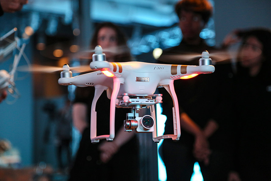
DJI drone with embedded GPS.
DJI offers three cameras for the drones. The high-end Phantom 3 Advanced offers 1080P HD video at 60 frames per second. The 1080P version costs $995.
In terms of privacy and government regulation, U.S. regulators are way behind Europe, Cheng said. “Other countries are way ahead of the [United States] in terms of working with drone companies,” he said. “In terms of privacy, the step ladder was the first tool for the invasion of privacy. They haven’t outlawed step ladders.”
The slow U.S. regulatory process has forced some manufacturers to go to other countries to test their drones, said Roger Sollenberger, 3D Robotics’ editorial director. “[U.S. regulations] have moved slowly here — despite the government knowing about worldwide drone rollouts. In Japan, they have been using drones to crop dust for 20 years,” he said.
Furuno’s Don Hanham with GNSS modules at NAB.
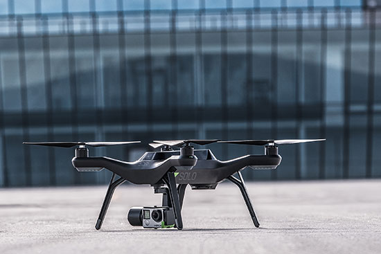
To signal increased interest in the commercial drone market, 3D Robotics raised $70 million dollars in funding, led by investor Qualcomm, Sollenberger said. The company, which partnered with action camera giant Go Pro, says its Solo drones can be used not only by broadcast companies, but for railroad track and building inspections.
As GPS World reported, Furuno Electric Co.’s latest multi-GNSS receiver module, GN-87, has been adopted for the new quadcopter Bebop Drone. The broadcast market has been a good one for company’s timing products, drone integration and even weather prediction, said Don Hanham, a Furuno sales and marketing consultant.
Furuno is marketing its Doppler Weather Radar System for broadcast. The system allows weather predictors to follow the development of short, localized rainstorms and extreme weather conditions.
Booz Allen Hamilton Releases Report on 2015 Automaker Priorities
The era of automotive connectivity, and subsequent heavy competition, is the focus of Booz Allen Hamilton’s new report, “Getting the Customer Experience Right: Auto Industry Priorities in 2015.”
The company says that automakers should consider six key priorities this year: deliver innovation in months, not model years; differentiate with new partnerships to catch customers’ attention; secure connectivity to reinforce a relationship of trust with customers; address the “so what” of connected cars; personalize the customer experience via the tremendous potential buried in data; and find and build the market for alternative fuel vehicles.
In terms of big connected vehicle technologies this year, Jon Allen, a principal with Booz, cites 4G pipe in GM and Audi vehicles and over-the-air updates by Ford and BMW, among others. “New parental controls in the Chevy Malibu report average speed and near misses while also preventing drivers from turning on the stereo until seatbelts are fastened. It’s easy to imagine this across vehicles, with parents receiving text messages in real time,” he said.
Allen said, in terms of vehicle connectivity, automakers must answer the “so what” to set themselves apart from the competition. “We have yet to see the seminal, game-changing connectivity plays. Most companies are still in the ‘features’ mindset, offering new à la carte enhancements,” he said. “They’re not yet articulating a top-down strategy for re-envisioning the customer experience with connectivity.”
One of the company’s six priorities concerns connected security, which has been a big industry issue since the recent release of the Markey Report, which focused on how vehicles can be hacked. “We have clients who get it. They’ve identified a senior leader to champion vehicle cyber security and backed them up with a cross-functional team that works closely with counterparts across the organization — in product engineering, supply chain, safety, privacy and IT,” Allen said. “Other OEMs are still formulating their approach. That said, there are pockets of cyber security across every organization, focused on implementing security controls on individual parts. The challenge is taking the next step —moving from this segmented, ‘assembly line approach’ to a more unified program that focuses on securing the complete vehicle ecosystem.”
Allen said the company has to speak honestly to customers and regulators about how to manage vehicle cyber security risk. “Industry leaders must prioritize their security approach to ensure that higher risk scenarios are addressed first, rather than try to take on all elements of the challenge at once,” he said.
Another priority addresses the long lead times, by automakers, to develop and roll out new features, which is a challenge, Allen said. “Consumer electronics, telecommunications and software companies are redefining the traditional industry boundaries that once distinguished them from OEMs. These companies focus on connectivity and services from the start of their product design process,” he said. “The key for automakers going forward is to continue learning from these new competitors, particularly around rethinking the vehicle lifecycle, connected product design, and managing vehicle software updates after purchase. In the near future, automakers will need different approaches to building and enhancing infotainment systems that can keep pace with customer demands.”
The marriage of autonomy and connectivity is a game-changer, Allen said. “It isn’t just about plugging vehicles in to the Internet of Things. Autonomy transforms transportation,” he said. “When a car drives you, it becomes a retail outlet, a personal assistant, even a trusted chaperone — that all depends on getting both autonomy and connectivity right.”
The rise of autonomous vehicles gets to the fundamental need for industry leaders to be willing to reimagine their product, Allen said. “Autonomous capabilities are not just about engineering a safer, more efficient, and more appealing mode of transportation. That’s important, but it’s really about a distinctly different product, one that creates a sustained, services-based relationship with the customer,” he said. “It will focus on the driving experience not just behind the wheel, but sitting comfortably inside of a self-driving vehicle. The connected, autonomous vehicle will change automotive for the better — and forever.”
Allen said his company is seeing OEMs look beyond their individual vehicles to see the emerging connected society that includes ride sharing, multi-modal transportation and connected cities. “The way we go from point A to point B will look and feel drastically different 25 years from now; many OEMs are beginning to accept the change and embrace the challenge,” he said.
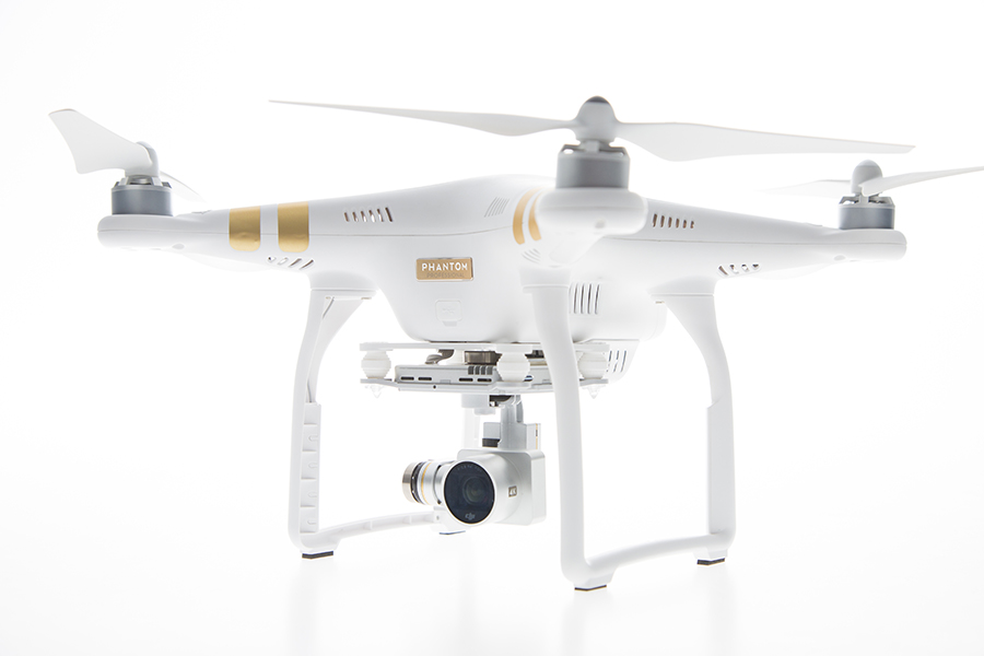
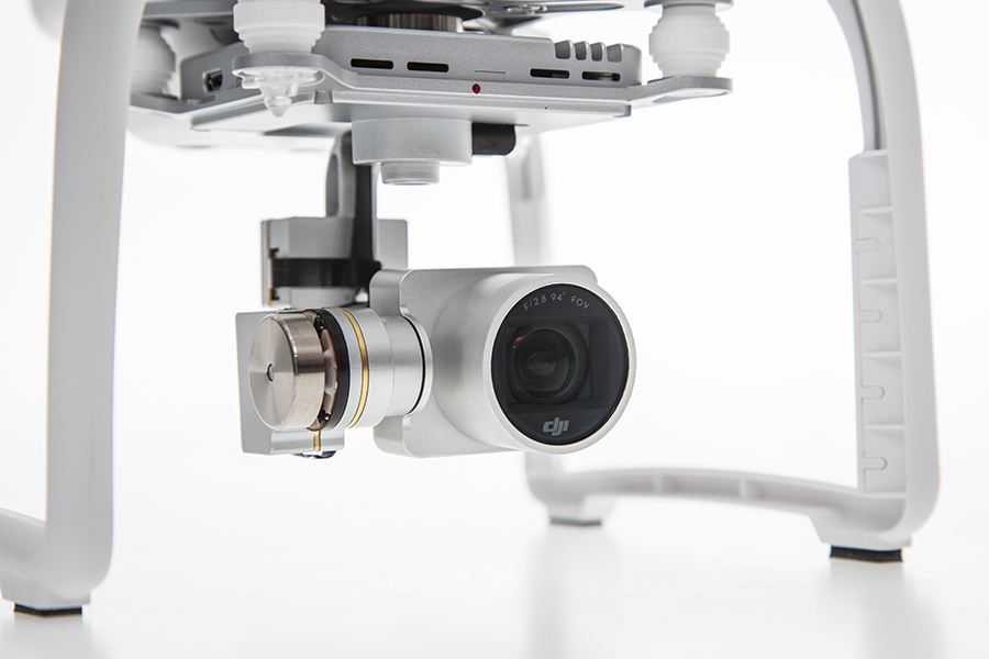
DJI has launched a new drone in its Phantom series. The Phantom 3 comes in two variations, Professional and Advanced, both of which provide greater control and creative options than the popular Phantom 2. On April 8, DJI held three simultaneous events in London, Munich, and New York to mark the release of the Phantom 3.
Both Phantom 3 versions feature the strongest professional control features DJI has developed so far. Using DJI’s Visual Positioning system, the Phantom 3 can hold its positioning indoors without GPS and can easily take off and land with the push of a button. With Vision Positioning technology, visual and ultrasonic sensors scan the ground beneath the Phantom 3 for patterns, enabling it to identify its position and move accurately.
DJI’s Lightbridge technology is also integrated, enabling control at up to 1.2 miles (2 km) away and a live HD video stream from the camera with almost no latency.
“In developing the next generation Phantom, DJI remained committed to providing a top-tier flight experience in one easy-to-use platform,” said DJI CEO Frank Wang. “We pride ourselves in creating a flying camera that fits in a backpack and can be ready to take professional quality videos from the sky in less than a minute.”
The Phantom 3 Professional is capable of shooting 4K video at up to 30 frames per second, while the Phantom 3 Advanced records at resolutions up to 1080p at 60 frames per second. These cameras are stabilized using 3-axis gimbals to keep the video smooth regardless of flight or wind conditions.
Both models shoot 12-megapixel photos using a 94-degree FOV, distortion-free lens, and a high-quality, 1/2.3-inch sensor that is more sensitive to light than the sensor in previous Phantom 2 Vision models.
All camera settings — including ISO, shutter speed and exposure compensation — can be set using both the DJI Pilot app and the physical controls on the remote controllers. The DJI Pilot app also features a Phantom 3 flight simulator for virtually practicing aerial maneuvers, and a Director feature, which automatically edits the best shots from flights into short videos that can be shared immediately after landing. The upgraded app also allows pilots to livestream their flights to YouTube.
“Pilots, whether they are journalists, extreme athletes, or global travelers — will not just be able to share aerial videos of where they were, but will also be able to send a YouTube link to their friends and colleagues to show them the aerial perspectives of where they are right now,” said DJI’s San Francisco General Manager Eric Cheng. “This has tremendous potential for changing the way we share experiences with one another.”