Global drone manufacturers 3DR, DJI, GoPro and Parrot today are forming the Drone Manufacturers Alliance, a coalition intended to serve as the voice for drone manufacturers and their customers across civilian, governmental, recreational, commercial, nonprofit and public safety applications.
“We will advocate for policies that promote innovation and safety, and create a practical and responsible regulatory framework,” said Kara Calvert, director of the Drone Manufacturers Alliance. “There are significant economic and social benefits to drone operations in the U.S., and industry must work with policymakers to ensure a safe environment for flying.
“The Drone Manufacturers Alliance believes a carefully balanced regulatory framework requires input from all stakeholders and must recognize the value and necessity of continued technological innovation. By highlighting innovation and emphasizing education, we intend to work with policymakers to ensure drones continue to be safely integrated into the national airspace.”
The VN-360 OEM GPS-Compass module provides an accurate, True North heading solution for systems integrators seeking a reliable alternative to magnetic-based sensors to improve the capabilities and performance of next-generation manned and unmanned systems. Unlike digital magnetometers that can be affected by ferrous materials, the VN-360 heading solution provides a cost-effective GPS-based alternative. With two onboard GNSS receivers, the VN-360 calculates the relative position between its two GNSS antennas to derive a heading solution an order of magnitude more accurate than a magnetic compass. It supports a variety of GNSS antennas that can be mounted on the host platform with a separation distance from a few centimeters to several meters. Applications include antenna pointing, multirotor UAVs and aerostats, automated agriculture, heavy machinery, ground robots, weapons training, warfare simulation and direct surveying.
The SDX software-defined GNSS simulator is now available in version 16.2. For real-time kinematic application, it is now possible to synchronize multiple simulators using a 10-MHz reference and pulse-per-second (PPS) signal. Users can modify pseudorange from the graphical user interface or the application program interface (API) in real time. Each satellite can be controlled individually or together. Trajectories can be imported from CSV files, and raw datalogging is improved. The navigation message can be changed in real time during the simulation. There is now an alternative to python API with the C++ open source API (other programming languages, such as C#, will be supported in the future.)
Designed for hydrographic tasks from shallow to deep water
The Apogee-M motion reference unit and the Apogee-U inertial navigation system (INS) are both made of titanium and have a depth rating of 200 meters. The Apogee Series is an accurate INS based on robust micro-electro-mechanical systems (MEMS) technology with a high degree of precision — 0.008 degrees in roll and pitch in real time — while delivering a robust and accurate heading from the continuous fusion of GNSS and IMU data. Apogee-M and Apogee-U are designed to mount close to the sonar head for hydrographic tasks in shallow or deep water. They provide a real-time heave accurate to 5 centimeters, which automatically detects the wave frequency and constantly adjusts to it. When wave frequency is erratic or in case of long-period swell, the delayed heave feature can allow survey in rough conditions with a more extensive calculation, resulting in a heave accurate to 2 cm displayed in real-time with a short delay. Apogee sensors can be paired with any survey-grade GNSS receiver or with one offered by SBG Systems.
The Piksi is a high-performance GPS receiver with real-time kinematic (RTK) functionality for centimeter-level relative positioning accuracy. Designed for integration into autonomous vehicles and portable surveying equipment, it has a fast position-solution update rate and low-power consumption in a small form factor. An open-source architecture with a high-performance digital signal processor on board and a flexible correlation accelerator make it suitable for GNSS research. Features include centimeter-accurate relative positioning (carrier-phase RTK); GPS, GLONASS, Galileo and SBAS signals; 50-Hz position/velocity/time solutions; and integrated patch antenna and external antenna input.
BYOD program offers a range of configurations for a variety of jobs
Anatum Field Solutions (AFS) has launched a nationwide Bring Your Own Device (BYOD) submeter GNSS and centimeter real-time kinematic (RTK ) GNSS receiver rental program. AFS rentals target high-accuracy users in GIS, UAV, environmental, engineering, surveying, agriculture, electric/gas/water utilities, pipeline, forestry, mining, transportation, construction, architecture and government markets. AFS offers all mobile GIS devices including Apple iOS, Android, Windows and Windows Mobile/EHH. It also stocks various GNSS receivers such as Eos Arrow (submeter and centimeter), SXBlue (submeter and centimeter), Trimble R1 (1 meter) and BadElf (1–3 meters) in a variety of configurations.
The FC-5000 field controller, with its 7-inch sunlight-readable display, is designed to provide operators a larger, more versatile and faster handheld computer for the modern construction site. The display has a capacitive touch interface — with finger, glove, small-tip stylus and water-capable options — that is optically bonded to increase visibility. With the press of a key, a user can change the orientation of the screen from portrait to landscape to increase visibility when viewing maps or drawings. The controller is compatible with all Topcon GNSS receivers and total stations, operating MAGNET Field, Site and Layout software. It has two built-in cameras: an 8-MP camera with autofocus and LED flash for field photography, and a 2-MP camera on the front for video meetings. Additional features include 64 GB of flash storage, an optional 4G LTE cellular modem, internal GPS navigation, Bluetooth and Wi-Fi, and a battery life of 10-plus hours.
Phantom 4 features obstacle avoidance, active tracking
The Phantom 4 quadcopter uses advanced computer vision and sensing technology to make professional aerial imaging easier. Its onboard intelligence makes piloting and shooting images easier through features such as its Obstacle Sensing System and ActiveTrack functionality. The Obstacle Sensing System features two forward-facing optical sensors that scan for obstacles and automatically direct the aircraft around impediments, reducing risk of collision, while ensuring flight direction remains constant. Obstacle avoidance also engages if the user triggers the drone’s “Return to Home” function to reduce the risk of collision when automatically flying back to its takeoff point. With ActiveTrack, the user can keep the camera centered on a subject. ActiveTrack allows users running the DJI Go app on iOS and Android devices to follow and keep the camera centered on the subject as it moves by tapping the subject on their smartphone or tablet.
The Pteryx UAV is a photomapping tool designed to help with photogrammetry, land property surveillance, environmental survey, search and rescue, precision agriculture, research, and in the energy sector. With a two-hour flight time, missions can be planned with the endurance reserve needed to overcome the large distances and worst-case changing weather conditions. Pteryx is designed to fly at speeds of about 50 km/h in light or medium wind speeds. The Pteryx can lift up to 1 kilogram of cargo: cameras, camcorders or other research equipment. The payload is housed in a roll-stabilized head on the front of the fuselage. The Pteryx can also accommodate a wide variety of sensors, which are installed in an easy to replace camera head. The Pteryx is delivered with a 16 MPx APS-C (crop sensor) daylight camera and wide lens, with other sensor options available.
The M2-D is a miniature stabilized gyro with electro optical (EO) and infrared imagers. The system is designed for mobile, marine and aerial unmanned applications. The M2-D is compact at 3 inches tall and 2 inches in diameter. The gimbal is fully gyro stabilized and packs sensor technologies previously only available in much larger payloads. The infrared FLIR brand pan-tilt-zoom thermal imaging camera has an optical telephoto zoom in a lightweight 160-gram payload. The high-resolution thermal imaging sensor with digital zoom integration lets users capture stable video in total darkness. For daytime operations, the gimbal has a full-color visual camera with optical 6x zoom to ~4 degrees. The optical zoom is then enhanced with digial zoom integration for stable long-range imaging.
Surveys large areas or objects to generate fast, precise data
Version 2 of the AibotX6 hexacopter features high-precision (HP) GNSS for surveyors. The system also can be installed in existing AibotX6 hexacopters. With Version 2, the precision and quality of surveying data is significantly improved with RTK technology based on the Leica Geosystems SmartNet correction data service. Post-processing is also possible. The new AibotX6 HP GNSS workflow guarantees precision of up to 2-centimeter position accuracy. Besides allowing the use of existing surveying hexacopters, continuing generation and processing of data can be done with the fully integrated software Aibotix AiProFlight. The Aibot X6 can carry a variety of sensors weighing up to 2 kilograms.
Integrates GNSS for challenging maritime positioning
The new DPS 432 combines full decimeter accuracy with high integrity and availability of GNSS data, supporting the safety and efficiency of offshore operations that rely on advanced dynamic positioning (DP) systems. It integrates signals from GPS, GLONASS, BeiDou and Galileo, and regional correction signals including SBAS and G4 services from Fugro, to ensure high flexibility for DP operations globally. Suited to complex operations, the system increases satellite availability, improves integrity monitoring and enables more precision under challenging signal tracking conditions. The DPS 432 features a sophisticated engine that runs in a safe mode protected from unintended user operations.
The aera 660 features a 5-inch capacitive touchscreen display that has been optimized for cockpits and various types of flying. It has a built-in GPS/GLONASS receiver and rich, interactive maps that can be viewed in portrait or landscape modes. Cost-effective database options along with Wi-Fi database updating capabilities allow customers to access up-to-date data, including daily U.S. fuel prices. Bluetooth supports the display of ADS-B in traffic and weather from a variety of sources, including the GDL 39/GDL 39 3D, Flight Stream and the GTX 345 ADS-B transponder. The aera 660 withstands the harshest environments, meeting stringent temperature tests and helicopter vibration standards. Depending on settings and external connections, pilots can receive up to four hours of battery life on a single charge.
Unmanned aerial vehicle maker DJI has launched the Phantom 4, a quadcopter drone that uses highly advanced computer vision and sensing technology to make professional aerial imaging easier.
The Phantom 4 expands on previous generations of DJI’s Phantom line by adding on-board intelligence that make piloting and shooting great shots easier through features such as its Obstacle Sensing System, ActiveTrack and TapFly functionality.
“With the Phantom 4, we are entering an era where even beginners can fly with confidence,” said DJI CEO Frank Wang. “People have dreamed about one day having a drone collaborate creatively with them. That day has arrived.”
The Phantom 4’s Obstacle Sensing System features two forward-facing optical sensors that scan for obstacles and automatically direct the aircraft around impediments when possible, reducing risk of collision, while ensuring flight direction remains constant.
If the system determines the craft cannot go around the obstacle, it will slow to a stop and hover until the user redirects it. Obstacle avoidance also engages if the user triggers the drone’s “Return to Home” function to reduce the risk of collision when automatically flying back to its take off point.
With ActiveTrack, the Phantom 4 allows users running the DJI Go app on iOS and Android devices to follow and keep the camera centered on the subject as it moves by tapping the subject on their smartphone or tablet. Perfectly framed shots of moving joggers or cyclists, for example, only require activating the ActiveTrack mode in the app.
The Phantom 4 understands three-dimensional images and uses machine learning to keep the object in the shot, even when the subject changes its shape or turns while moving. Users have full control over camera movement while in ActiveTrack mode — and can move the camera around the object while it is in motion as the Phantom 4 keeps the subject framed in the center of the shot autonomously. A “pause” button on the Phantom 4’s remote controller allows the user to halt an autonomous flight at any time, leaving the drone to hover.
By using the TapFly function in the DJI Go app, users can double-tap a destination for their Phantom 4 on the screen, and the Phantom 4 calculates an optimal flight route to reach the destination, while avoiding any obstructions in its path. Tap another spot and the Phantom 4 will smoothly transition towards that destination making even the beginner pilot look like a seasoned professional.
The Phantom 4’s camera, an aerial-optimized 4K imaging device, has undergone an upgrade that includes improved optics for better corner sharpness and reduced chromatic aberration. The Phantom 4 also has DJI’s signature Lightbridge video transmission system onboard, allowing users to see what their camera sees in HD and in real-time on their smart devices at a distance up to five kilometers (3.1 miles).
The Phantom 4’s form factor, the classic quadcopter, has been redesigned and redefined to emphasize elegance and smoother, more aerodynamic lines. Its frame incorporates a lightweight composite core to provide enhanced stability and more agile flight. The core features a redesigned gimbal that provides more stability and vibration dampening, and has been repositioned for a better center of gravity and to reduce the risk of propellers getting in the shot.
Refinements to motor efficiency, power management and a new intelligent battery have extended the Phantom 4’s flight time to 28 minutes, which means more time in the air to capture professional photos and video.
DJI crafted the Phantom 4 with reliability in mind, including redundant inertial measurement units (IMUs) and dual compasses onboard. It uses new push-and-lock propellers that are faster to install and more secure in flight.
In addition to intelligence and ease-of-use, the Phantom 4 is built for fun, DJI said. Its new “Sport Mode” for advanced flyers gives a taste of what drone racing feels like. In “Sport Mode,” the Phantom 4 can fly 20 meters per second (45 miles per hour) and ascends and descends more rapidly than in other modes. The craft’s acceleration and top speed in “Sport Mode” also mean it can reach locations for shots faster and capture shots users couldn’t get before.
“Though the Phantom 4 is easy to use, let’s not forget it is a high-performance aircraft powered by unparalleled DJI technology,” said Senior Product Manager Paul Pan.
UAV company DJI is offering its first tuned propulsion system designed for all-weather use in industrial applications and filmmaking.
The E2000 propulsion system has the power to handle add-ons such as computing devices and advanced imaging equipment. It uses a combination of 6010 motors, 1240S/X field-oriented control (FOC) electronic speed control (ESCs), and 2170 propellers to carry payloads of 1800–2500 grams (g) per axis, with a maximum thrust of up to 5100 g/rotor (50V, sea level).
The 6010 motor’s bearings are fully sealed to prevent flu
ids such as salt water from causing corrosion. A special surface coating applied to the stator also greatly improves its ability to withstand rusting.
To more effectively dissipate heat generated under intensive industrial use, the 6010 motor features an integrated centrifugal cooling system that effectively cools the motor while keeping dust and micro particles out. The 1240S FOC ESC is equipped with a silica thermal pad and heat sink for maximum heat transfer and dissipation.
The E2000 is available in Standard and Pro versions to meet the demands of professional and industry users. Both the 6010 Standard and Pro motor bearings are fully sealed to prevent fluids like rain, pesticide, and salt spray from entering and causing corrosion. A special surface coating applied to the stator also greatly improves its ability to withstand rusting.
The same effective weather sealing has also been applied to the external 1240S ESC found with the E2000 Standard. The E2000 Standard has an IP56 rating.
Drone maker DJI is introducing enhancements to its Phantom 3 and Inspire 1 quadcopters at CES 2016, a consumer electronics and technology trade show held Jan. 6–9 in Las Vegas.
\The Phantom 3 4K’s introduction is the result of strong consumer demand for top resolution cameras and ultrasonic sensors, the company said, which enable flight indoors and in areas with a weak GPS signal. The Phantom 3 4K comes with an integrated, gimbal-stabilized 4K camera and has remote-control buttons for playback, video recording and camera shutter.
Instead of DJI’s Lightbridge video-transmission system, the Phantom 3 4K uses built-in WiFi to transmit the video downlink and on-screen data. The drone’s WiFi video downlink is effective up to a distance of 1.2 kilometers.
“The Phantom 3 4K fills an important gap in our Phantom portfolio. It offers a high-quality camera and smart navigation system for a lower price than our professional models. This is possible, as we have replaced the DJI Lightbridge system with a built-in WiFi link,” said Paul Pan, DJI’s senior product manager.
The Phantom 3 4K will stay aloft for 25 minutes on a full battery charge. DJI also has made stylistic change to its Inspire 1 Pro. The Inspire 1 Pro Black Edition comes with a black controller, battery and a shell with a matte finish. It comes equipped with DJI’s best-in-class Micro Four Thirds camera, the Zenmuse X5.
In celebration of DJI’s 10th anniversary, the promotional price of the DJI Phantom 3 4K edition is $799, starting Jan. 6. This promotion also extends to the Phantom 3 Advanced model, now priced at $799, and the Phantom 3 Standard, at $499. DJI says the price may be subject to change.
The original Inspire 1 Pro, with a white shell, battery case and controller, will continue to be sold alongside the new model.
“One of the most-frequent questions we get from professional drone operators is ‘when will DJI come out with a black Inspire?’ The answer is now,’” said Ferdinand Wolf, manager of DJI Studios Europe.
DJI’s main booth at CES 2016 will be in South Hall 2, No. 25602, and Central Hall, No. 9845. The exhibits will feature a flying cage for attendees to attempt flying a drone with First Person View, an Osmo Zone for testing the filmmaking tool, a showcase of solutions created with the DJI SDK and a display of work created by the SkyPixel community.
Drone-maker DJI has launched a public beta version of its new geofencing system in North America and Europe.
Geospatial Environment Online (GEO) will provide drone users with up-to-date guidance on locations where flight may be restricted by regulation or raise safety or security concerns. With this major upgrade to DJI’s existing geofencing system, users will have access to live information about areas temporarily restricted from flight due to forest fires, major stadium events, VIP travel and other changing circumstances.
The GEO system will also show restricted areas around locations like prisons, power plants and other sensitive areas where drone flight would raise non-aviation security concerns.
To accommodate the large variety of authorized applications, GEO will allow drone operators with verified DJI accounts to self-authorize and temporarily unlock flight in some locations. Certain areas where drone flight is not allowed, such as Washington D.C., will remain as unlockable no-fly zones. Unlocking requires a DJI account verified with a credit card, debit card or mobile phone number. DJI will neither collect nor store the information, and the service is free.
The verified account is required only if a user chooses to fly in a location that might raise aviation safety or security concerns.
Use of GEO requires a drone firmware update and installation of a beta version of the DJI Go app.
Positioning and heading for mission-critical applications
The K528G dual-frequency, multi-constellation GNSS board provides the highest accuracy in differential positioning. It benefits from numerous constellation signals because of its advanced tracking performance of both GPS and GLONASS. The K528G can provide positioning and heading information generated by two antennas. It is designed for guiding and positioning construction engines, dredges, barges, shipping container cranes, mining equipment and intelligent transportation systems.
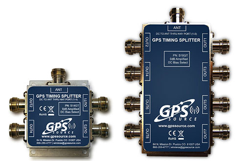
Designed for small-cell and distributed antenna systems
GPS Source has released of a line of GPS/GNSS splitters created for the small-cell wireless and distributed antenna system markets. Specifically designed for the L-band frequency, they can eliminate the cost of multiple antennas and long cable runs in wireless installations. With four or eight outputs, the new line of splitters make it possible to use a single GPS referencing antenna and cable arrangement for multiple synchronized systems. The splitters include features such as DC bias select and amplification. GPS Source RF signal splitters typically operate in conjunction with an active GPS antenna; consequently, a GPS RF signal splitter must have provisions for managing the DC voltage to the active GPS antenna. The S14GT and S18GT splitters will power an external GPS antenna from any of the RF outputs. A “hunt-and-pick” circuit is used to select only one DC input for power should more than one source be connected. Designed for redundancy, if the selected DC bias input should fail, the DC bias will automatically switch to another DC input to ensure an uninterrupted power supply to the active antenna.
For precision industrial, agricultural and military OEM applications
A new series of L1 band wideband antennas for OEM applications is offered in three formats:
▪ TW2106/TW2108 — GPS L1
▪ TW2406/TW2408 — GPS + GLONASS
▪ TW2706/TW2708 — Galileo, BeiDou, GPS + GLONASS
Each antenna type features Tallysman’s Accutenna technology, which provides high rejection of multipath signals, with low axial ratios and tight phase center variations (PCV). Each is available with a brickwall pre-filter option to protect against saturation by high level subharmonic and L-band signals. The antenna printed circuit boards (PCBs) are 56 millimeters in diameter with four plated holes for secure mounting. They are available with a variety of connectors and custom cable lengths, and can be custom-tuned. All of them are REACH and ROHS compliant.
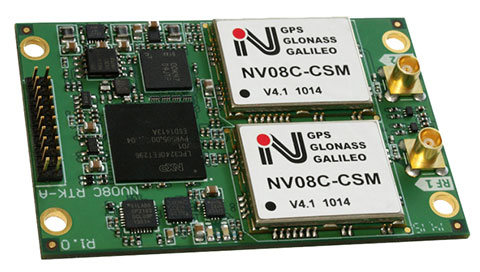
The NV08C-RTK-A is fully integrated multi-constellation L1 heading receiver with embedded real-tiime kinematic (RTK) functionality and compatibility with GPS, GLONASS, Galileo and BeiDou. The NV08C-RTK-A is designed for use in high-accuracy applications that demand low-cost, low-power consumption, a small form factor and high performance, such as construction, mining and industrial; environmental and structural monitoring; machine control; parallel driving systems; precision agriculture; UAVs; and robotics and intelligent machines.
The SLD-100 GNSS Rover accessory facilitates hydrographic measurement in bodies of water up to 100 meters in depth. it is designed for anyone who finds themselves needing to survey into bodies of water, streams and rivers. With survey-grade accuracy, the SLD-100 can be added to any brand GNSS RTK rover to allow for position and depth measurements to be made simultaneously. With a built-in 10-hour lithium battery and transmitter unit with Bluetooth connectivity, the SLD-100 provides standard-depth data streams in several industry-standard NMEA formats at 1 Hz, 4800 bps, providing compatibility with any hydrographic surveying software package. Position and depth information is externally logged on a computer or controller. Included transom mounting hardware enables easy installation.
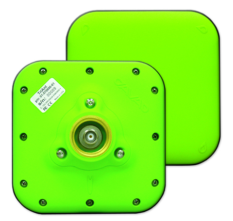
TriAnt is small, thin and rugged high-performance GNSS antenna. It measures 128 x 128 millimeters (mm) square and 39 mm thick. It can be mounted with three screws to flat surfaces. It is designed for applications such as machine control and surround anennas of the TRIUMPH-4X. The antenna cable is routed through the center of the antenna (TNC connector) for protection in harsh environments. The TriAnt can also be mounted on poles (1–14 inches thread) using its mount-pole attachment, which increases the thickness to 54.5 mm.
The X20i L1 GPS receiver by CHC Navigation is powered by a high-precision L1 GPS engine. Its integrated Bluetooth chip enables it to wirelessly collect submeter positions in real- time or centimeter post-processed on an iPhone or iPad. All location-aware apps on the iPhone and iPad are compatible with the X20i. Immediately after pairing and answering the security question allowing the X20i to take control of location services on the iOS device, 1 million iOS applications are capable of utilizing the high-accuracy data of the X20i, and become accurate to either 1 foot or 1 centimeter. Apps that can make use of the high accuracy include TerraGo Edge, ESRI’s ArcView Connector and those by CarteGraph Systems.
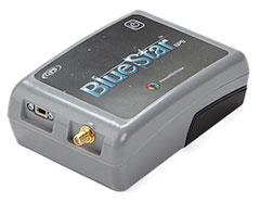
BlueStarGPS offers both GPS and GNSS options in a rugged, lightweight package. The BlueStarGPS device was designed to meet sub-meter mapping and data-collection needs in the pipeline and utility industries. It provides sub-meter precision without post-processing, and maintains accurate positioning when the SBAS signal is obstructed. This means it can function under trees, around buildings and in rugged terrain where other receivers can fail. The BlueStarGPS is designed specifically for use with Android mobile devices, such as smartphones, tablets or notebook computers, as well as cable and pipe “locating” tools with a connectivity range of up to 1 kilometer.
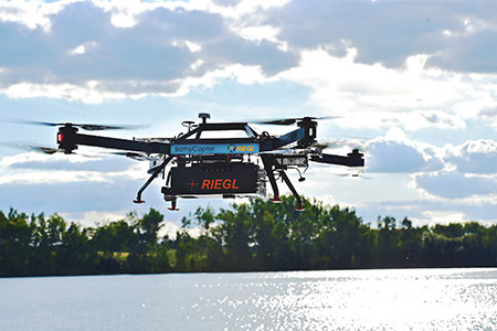
UAV measures through water surfaces of rivers, lakes
The RIEGL BathyCopter is a small-UAV-based surveying system capable of measuring through the water surface. It’s suitable for generating profiles of rivers or water reservoirs. The platform design integrates a topo-bathymetric green laser depth meter, an APX 15 inertial measurement unit (IMU)/GNSS with antenna, a control unit and a digital camera. Applications include generation of river profiles, survey of reservoirs and canals, landscaping, support of construction projects, and surveys for planning and carrying out hydraulic engineering work.
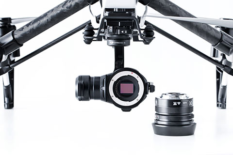
The Zenmuse X5 is a micro four-thirds (M4/3) camera designed specifically for aerial use. With a large sensor, aerial image makers will be able to capture up to 13 stops of dynamic range, enabling capture of high-resolution 16-megapixel photos or 4 k, 24 fps and 30 fps videos in complex lighting environments. It supports four interchangeable lenses. The Zenmuse X5 is designed for creation of high-quality aerial maps and 3D models, industrial and utility inspection, and professional video capture.
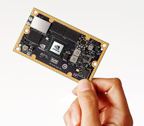
The NVIDIA Jetson TX1 module is designed to power smart devices — including drones that don’t just fly by remote control, but navigate their way through a forest for search and rescue. It is an embedded computer designed to learn to recognize objects or interpret information, incorporating capabilities such as machine learning, computer vision and navigation into a single system. This technology expands the ability of machines to operate on their own and adapt to their surroundings by recognizing images, processing conversational speech, or analyzing a room full of furniture and finding a path to navigate across it.
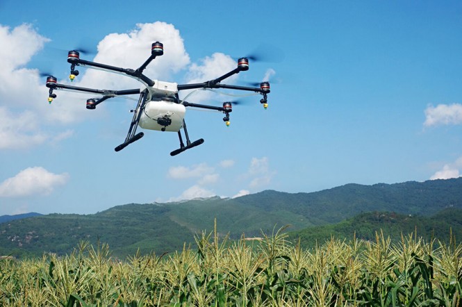
Unmanned aerial vehicle maker DJI has launched of a smart, crop-spraying agricultural drone. The DJI Agras MG-1 is dustproof, water-resistant and made of anti-corrosive materials. It can be rinsed clean and folded up for easy transport and storage after use.
The eight-rotor Agras can load more than 10 kilograms of liquid for crop-spraying and can cover between seven and 10 acres per hour. It is more than 40 times more-efficient than manual spraying, according to DJI. The drone can fly up to eight meters per second and adjusts spraying intensity to flying speed to ensure even coverage.
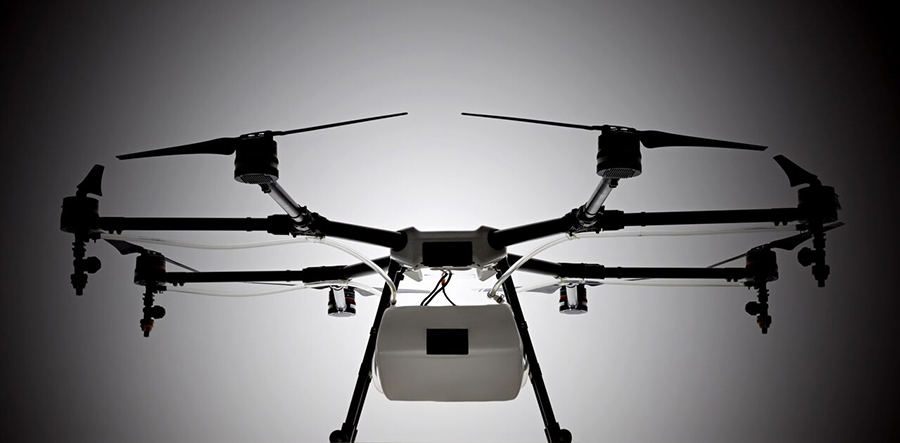
The Agras features DJI’s flight-control system and microwave radar to ensure centimeter-level accuracy. During flight, the drone scans the terrain below in real time, automatically maintaining its height and distance from plants to ensure application of an optimal amount of liquid. DJI’s real-time Lightbridge 2 transmission system is also onboard.
The DJI Agras MG-1.
Users can select automatic, semi-automatic or manual operation modes, depending on terrain, with uniform spraying carried out via the drone’s nozzles. The drone has four replaceable, ceramic nozzles, each powered by a motor. The included nozzles can be used for thousands of hours of spraying. Downward airflow generated by the rotors increases spraying velocity and ensures the agent will reach plant stems and leaves near the soil.
The Agras MG-1’s body is sealed, and features an integrated centrifugal cooling system designed to extend motor life by up to three times. Triple-filtration cuts off intake of mist, dust and large particulates to reduce wear from impurities. As the drone flies, air enters the aircraft body via the front inlet. It is then filtered and passes through each of the aircraft’s arms to the motors, capturing heat from all components and the entire structure. Heat is then dissipated by venting into the surrounding air.
The DJI Agras MG-1 is designed for crop spraying.
The drone’s intelligent memory function means after the Agras MG-1 is brought back to base for refill or recharge, it will return to its last memory point to pick up spraying where it left off.
Users control the Agras with a custom DJI remote. Its low-energy display panel gives real-time flight information and lasts for extended periods on a single charge.
The Agras MG-1 will initially be available in China and Korea and later in other markets.
Hasselblad Group and DJI have announced a corporate partnership through DJI’s acquisition of a strategic minority stake in Hasselblad. DJI also joins Hasselblad’s board of directors.
The partnership will allow opportunities and new ways of combining the technical knowledge and inventive spirit of the two industry leaders in their respective fields, according to a news release from the two companies.
“We are honored to be partnering with DJI, the clear technology and market leader in its segment,” said Perry Oosting, Hasselblad’s CEO. “DJI and Hasselblad are equally enthusiastic about creativity and excellence, and we are looking forward to sharing technical expertise and paving the way for future innovations.”
Hasselblad and DJI will each focus on their individual strategic directions and related growth opportunities, with marketing and branding platforms continuing to delineate the two companies. Hasselblad cameras and equipment will continue to be handmade in Sweden, and DJI will continue to make products in Shenzhen, China.
“Hasselblad and DJI share a passion to provide creative people with cutting-edge, inventive technology to help them take visual storytelling to the next level,” said Frank Wang, DJI’s Founder and CEO. “With this partnership, we combine our strengths to further push the borders of what’s possible in imaging technology.”
Hasselblad has a history of aerial photography — its technology was used in space on several NASA missions, including the first landing on the moon and several of the Apollo missions.
SkyPixel, an aerial photography community run in cooperation with DJI, has announced a drone photography competition. The 2015 SkyPixel Photo Contest is accepting entries starting Monday, Oct. 26, at 00:00 Hong Kong time (GMT+8). Prizes include cash and DJI drones and related equipment.
The contest invites both budding and professional aerial photographers to enter a selection of their best work. The competition is split into two groups, Professional and Enthusiast, each with their own awards for the following categories: Beauty, Unique Dronies, and Drones in Use (aimed at showcasing drones in the air), in addition to an overall Grand Prize.
To celebrate the rise and popularity of aerial photography, the Popular Award will be given to the contest’s 10 most popular photos, based on number of likes received on SkyPixel. Winners will be announced on Jan. 7, 2016.
SkyPixel users can submit their entries at the competition page.
DJI is offering two new cameras for its DJI Inspire 1 professional aerial camera platform.
The new Zenmuse X5 is a commercially available micro four-thirds (M4/3) camera designed specifically for aerial use. With a large sensor, aerial image makers will be able to capture up to 13 stops of dynamic range, making it easy to capture high-resolution 16 megapixel photos or 4k, 24fps and 30fps videos in complex lighting environments.
Zenmuse X5 users will have more options for capturing images in the sky through additional supported lenses and full wireless aperture and focus control. At the time of launch, the Zenmuse X5 will support four interchangeable lenses, including the DJI MFT 15mm f/1.7 ASPH lens, Panasonic Lumix 15mm G Leica DG Summilux f/1.7 ASPH lens, Olympus M.ZUIKO DIGITAL ED 12mm f/2.0 lens, and Olympus M.Zuiko 17mm f/1.8 lens. While the Zenmuse X5 is in flight, pilots can adjust both focus and aperture via the DJI GO app or through DJI’s previously announced Follow Focus system.
The Zenmuse-X5 aerial camera.
The camera’s lightweight 340-gram (0.75-pound) body integrates with DJI’s signature three-axis Zenmuse gimbal technology, creating effortlessly smooth video and stabilized long-exposure photos (up to 8 seconds).
“The professional applications of the Zenmuse X5 are almost endless,” said Eric Cheng, DJI’s director of Aerial Imaging. “In addition to shooting professional-quality photos and 4K video, the new camera can be used to create high-quality aerial maps and 3D models, and can also help industrial teams get even more detail from their aerial imaging pursuits, for example, in utility inspection using a drone.”
DJI also announced the Zenmuse X5R camera, which shares the same sensor and lens compatibility with the X5, but records video both to an onboard microSD card as well as to a removable 512GB solid state disk (SSD) on the gimbal’s top plate. The Zenmuse X5R records CinemaDNG (RAW) video to the SSD, and opens up lossless 4k video recording in a compact form factor with video bitrates averaging 1.7 Gbps (with a maximum of 2.4 Gbps).
The Zenmuse X5R also offers a brand-new D-LOG mode that offers a broader array of color correction options in post production.
To support the management of Zenmuse X5R Cinema DNG files, DJI will release software to edit and convert RAW camera footage. CineLight, which will be available when the Zenmuse X5R camera is released later this year, simplifies users’ workflows by offering offline proxy editing before converting the CinemaDNG files to ProRes.
“In order to achieve the quality of video produced by Zenmuse X5 and X5R, pilots used to have to spend many thousands of dollars for large, complicated aerial equipment,” said Frank Wang, DJI CEO and founder. “Now, pilots can simply mount the Zenmuse X5 series cameras to their Inspire 1, put on their props, get up in the air, and have full control of their shot while in flight. This saves valuable time on film sets and makes high quality imaging for industrial applications smaller, lighter and easier to manage.”
By mounting a small, easy-to-install bracket, the Zenmuse X5 series cameras are fully compatible with existing DJI Inspire 1 platforms as an interchangeable option for the Inspire 1’s standard Zenmuse X3 camera.
The Zenmuse X5 is available for pre-order at store.dji.com for $4,499 (€4,999), including a DJI Inspire 1 and DJI’s MFT 15mm F1.7 ASPH lens, and will begin shipping before the end of September. The Zenmuse X5R will be available in Q4 2015 for $7,999 (€8,799). Both can be purchased as stand alone cameras with, or without lens. More information can be found at dji.com.
Lifeguards in the United States are testing how drones may help save lives in coastal waters. Cameras on drones can spot sharks from above, and drones are able to reach struggling swimmers faster than lifeguards to deliver life preservers.
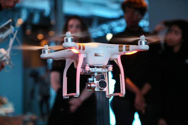
In Seal Beach, Calif., lifeguards are using the flying device to monitor sharks. “It’s an extremely valuable tool for our water observation,” said Joe Bailey, chief of Seal Beach’s Marine Safety and Lifeguard Department, told the Los Angeles Times. The Seal Beach Marine Safety Department purchased a DJI Phantom 3 drone to monitor sharks off the coast. Safety officials fly the device at least twice a week to track juvenile great white sharks.
Meanwhile, lifeguards in Long Branch, N.J., are testing using drones to get life preservers out to swimmers in the ocean faster than a lifeguard could reach them. It would not replace the rescue work done by lifeguards in the water, however, who would still swim or row out to a victim. But it would buy a struggling swimmer extra time.
The Phantom 3 in flight at a press event.
“This is not to cut back on any lifeguards. This is a lifeguard’s tool to help move them along a lot faster in making the save, getting a life preserver out to a person,” said Michael Sirianni, president of the Long Branch City Council, told the Asbury Park Press.
The drones would be especially helpful when conditions are extreme, such as big surf and high winds that make it difficult to reach someone stranded. The drones could fly out a mile or two to reach distressed stand-up paddle boarders, kite surfers or capsized boats. Its camera could help locate submerged persons quicker, while microphones and speakers could enable lifeguards to talk to a person in the water.