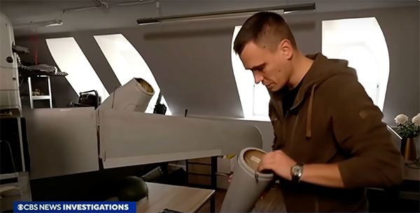
A Ukrainian intelligence assessment obtained by CNN and CBS reported an Iranian UAV downed in Ukraine contained technology from companies in the United States and other western countries. The White House has since launched an investigation as to how the technology — including semiconductors, GPS modules and engines — were obtained by Iran.
Screenshot: CBS video
The components removed from an Iranian Shahed-136 UAV totaled 52, 40 of which were manufactured by 13 different U.S. companies. The remaining components were manufactured by other western companies and companies based in Japan, Taiwan and China.The United States monitors exports and imposed restrictions and sanctions to prevent Iran from obtaining components for UAVs. Officials are now looking to enhance enforcement of the sanctions and are encouraging companies to monitor their supply chain, as well as identify third-party distributors who may be re-selling the technology to Iran.
U.S. companies are not alone in having to closely monitor their supply chains. U-blox, a Swiss semiconductor company, made a statement reinforcing its company policy, which bans the use of its technology in weapons. This was after u-blox GNSS modules were reportedly found in Russian UAVs.
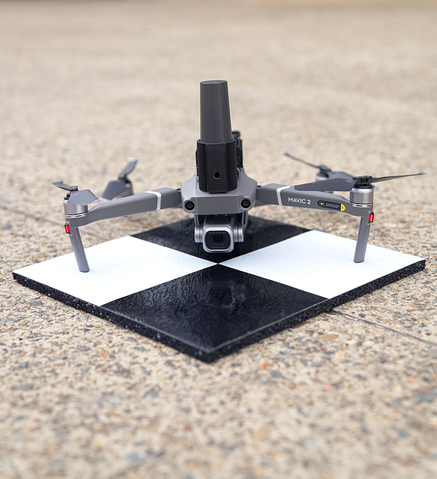
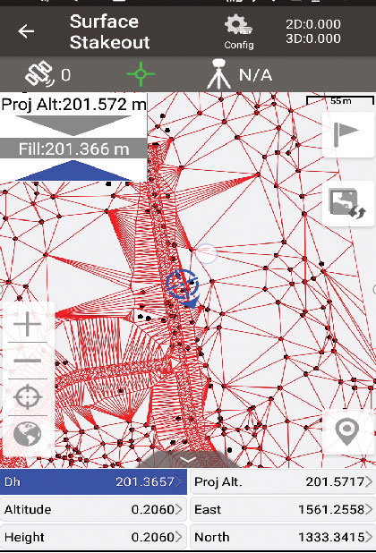
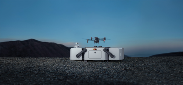
Position Partners has unveiled SmartSurveyor, which facilitates accurate, survey-grade aerial mapping and photogrammetry without the need for a connection between a camera shutter and a GNSS receiver.
The fully compact, handheld, aerial mapping survey rover is compatible with DJI Mavix 2 and 3 series and Phantom 4 Pro drones.
Image: Position Partners
The design is dissimilar to other drone mapping systems in that it works from a drone or smartphone and with two or more ground control points (GCPs) while using an ultra-matching technique.
Once data is captured by SmartSurveyor, all the photos and the GNSS file are uploaded to a PC and analyzed through the Agisoft UltraMatch workflow to confirm their accuracy before they are exported. Data can be managed in the cloud or on a local PC using software designed by MapSender.
Additionally, this mapping tool works in tandem with the AllDayRTK subscription GNSS network service so collected data can be uploaded to Tokara to remotely manage a project.
A photo taken in the aftermath of Hurricane Ian shows the massive destruction on Fort Myers beach. (Photo: felixmizioznikov/iStock/Getty Images Plus/Getty Images)
Not to harp on an event that’s already passed out of the headlines and national coverage, but Hurricane Ian — a Category 4 storm that hit Florida in September — was full of destructive winds and caused major damage that could be with us for years before things get fixed. One source also indicated that so far we have lost 157 people, mostly from drowning — nothing will ever fix those losses.
So harp on I will, especially about the role drones and drone pilots played in rescuing survivors, and determining and mitigating effects of the storm.
The place that took the hurricane hardest was Fort Myers on the southwest Florida coast. The following video is from a security camera.
While Hurricane Ian was making a mess of Cuba and crawling over the Caribbean and into the Gulf of Mexico, drones were already flying over areas where the storm could cross from the Gulf onto land — initially forecast around Tampa. But the forecast landfall continued to drift south, over where I live in Venice and 150 miles south of Tampa to Fort Myers.
Before landfall, drone operators in Fort Myers were gathering video/geolocation information on buildings and streets in the path that the forecast 14-foot storm surge might take. They identified areas of potential damage and places people might need rescue.
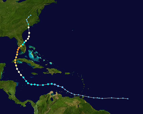
Map plotting the storm’s track and intensity using data from the National Hurricane Center and a NASA image. (Image: public domain/FleurDeOdile/Wikipedia)/
After the storm hit, first responders began searching more than 400 destroyed houses in Fort Myers, some using the pre-storm drone video to rescue any trapped survivors.
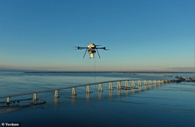
The need was not only for access in difficult conditions, but also for communications. AT&T reportedly got cell coverage up quickly in a couple of areas, and Verizon flew tethered drones (capable of flying for up to 1,000 hours) to restore phone coverage over a circular radius area of five to seven miles. Verizon also hooked up generators and engaged satellite internet coverage for local use, and took a portable cell-site on a barge out to Sanabel Island, which had been cut off from the mainland. T-Mobile put generators at cell-sites that lost power and deployed satellite and ground-based portable cell coverage.
Verizon tethered drones provided cellular service for first responders. (Photo: Verizon)
Powerful Drone
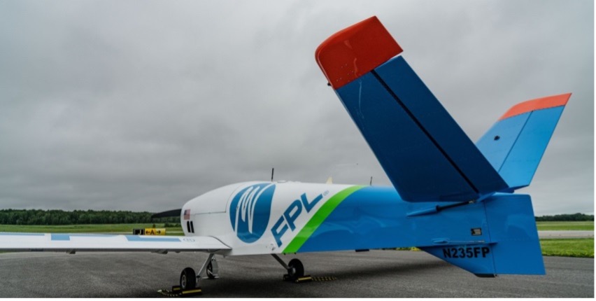
Loss of power was another issue. Florida Power and Light (FPL) flew its recently acquired fixed-wing FPLAir One drone to assess damage to its power distribution infrastructure, which supplies about 12 million people on Florida’s west coast.
FPL drone used in power loss assessment. (Photo: FPL)
Using the drone in damage assessment efforts enabled FPL to get suitable crews to the right places early in the recovery effort.
FPLAir One is a group 4/5 large UAV. It appears to be a Navmar Applied Sciences Corporation (NASC)/Sonex Aerospace TEROS unmanned aircraft, which is based on an earlier Sonex-powered glider design introduced in 2003. Because of this heritage and its rugged airframe, the TEROS is ideally suited for flights in high wind conditions — great for FPL’s long-range pre- and post-storm assessment application using FLIR and video cameras.
The drone’s extensive prior airframe proving is assisting NASC/Sonex in its quest for certification of TEROS by the Federal Aviation Administration (FAA). FAA certification will ultimately support its integration into the National Airspace System (NAS) and allow operators to move on from the individual FAA approvals required for each operational drone scenario.
Drones to the Rescue
The principal application for hundreds of drone flights by several organizations was search and rescue for missing residents, mostly in the flooded area in and around Fort Myers. Drones also helped rescue people in North Port, where floodwater was as high as four feet, collapsing roofs and trapping people in their homes.
Skydio provided drones for several search-and-rescue programs by police and other agencies, as well as coaching personnel who might lack experience in flying them. More than 500 drone flights were accomplished in the first days after the storm, a large number using autonomous flight capability, greatly assisting rescue efforts to locate trapped people. First responders were also able to determine whether access was possible, or what steps were initially needed to even enable access.
Insurance companies are also using drone assessment video, determining the level of damage to homes and vehicles, in an effort to put assistance where it was most needed early on. Using artificial intelligence to align food-stamp users with badly damaged homes identified on satellite images in Lee, Collier and Charlotte counties, GiveDirectly offered immediate $700-assistance to many survivors. If all these offers were accepted, the cost could be as much as $2.4 million in no-strings-attached immediate aid for those worst hit.
In the aftermath of the largest, most damaging hurricane to hit the United States since 1935, volunteers, first responders, drone pilots, aid agencies, and power, communication and insurance companies all made use of drones. These agencies and companies are still helping many thousands of people to survive and start the long task of picking up the pieces of their lives.
Atmos, a Dutch UAV manufacturer that develops high-end VTOL fixed-wing UAVs for mapping and surveying applications, expanded its global reseller network by signing a reseller agreement with Volatus Aerospace, a leader in commercial drones and UAV technology, in Canada.
Volatus will be responsible for the distribution of Marlyn Cobalt UAVs in Canada and will provide assistance and maintenance services to local UAV operators. The company brings extensive experience in aviation operations, safety, compliance and innovation to the evolving uncrewed aircraft market.
Marlyn Cobalt is the first fully autonomous hybrid (VTOL and fixed-wing) drone for mapping and surveying applications. With its patented design that combines the best of both worlds, Marlyn can take off vertically from anywhere and map fast and efficiently producing high-quality outputs for professional users. It is the only drone in its class that is built to perform even in harsh and windy conditions, while its easily swappable payloads provide operators with flexibility.
“We have an incredible team pushing the envelope on the entire spectrum of UAV technology,” said Glen Lynch, CEO at Volatus Aerospace. “The Marlyn Cobalt survey drone is an exciting new addition to our product offerings.”
A roundup of recent products in the GNSS and inertial positioning industry from the October 2022 issue of GPS World magazine.
OEM
Software
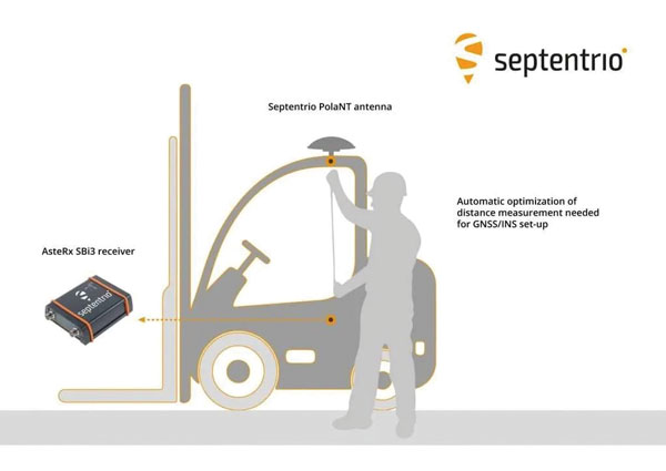
Aids GNSS/INS installation
Photo: Septentrio
The RxLeverArm software tool aids integration of GNSS receivers that include inertial navigation systems (GNSS/INS). RxLeverArm is part of Septentrio’s RxTools software package included with every Septentrio GNSS/INS receiver. The new tool visualizes, validates and automatically calibrates the exact distance between the INS sensor and the antenna, removing the need for accurate distance measurements with complex instruments. For lever-arm compensation, users only need to measure the rough distance between the INS sensor and the main GNSS antenna reference points on the vehicle. Data is then logged under open-sky conditions, which allows the RxLeverArm tool to optimize the initial rough distance measurement and prevent common errors such as sign inversion.
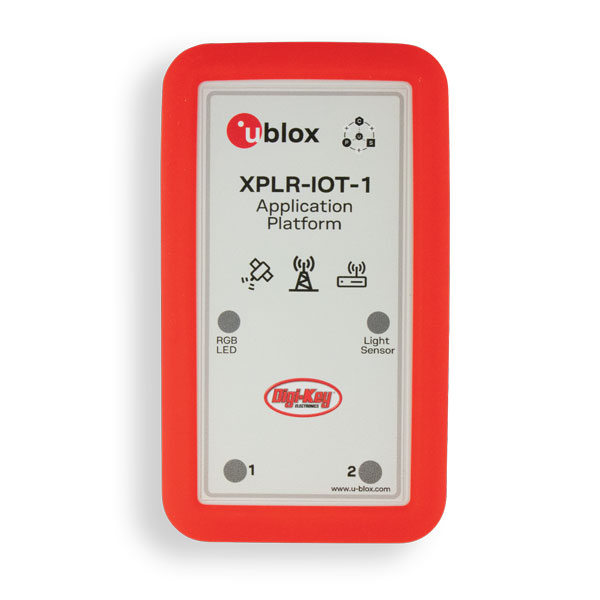
Enables proof of concept for IoT products and applications
Photo: u-blox
The u-blox XPLR-IOT-1 IoT explorer kit is an all-in-one package to test, evaluate and validate applications for the internet of things (IoT). The board hosts an ultra-low-power MAX-M10S positioning module capable of concurrently tracking four GNSS constellations, delivering highly reliable location data. Integrating relevant u-blox technologies and services into a capable prototyping platform with a vast selection of sensors and interfaces as well as cloud connectivity, XPLR-IOT-1 makes it easier to explore the potential of IoT applications.
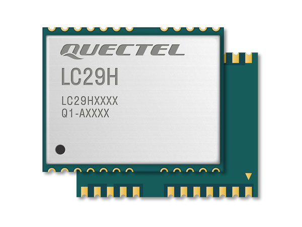
The LC29H is a dual-band multi-constellation GNSS module built using the Airoha AG3335 platform. It is available in multiple variants and optionally integrates real-time kinematic (RTK) and dead reckoning. The LC29H series offers high performance with power efficiency to meet the market needs of high-precision positioning at the centimeter and decimeter levels. The LC29H concurrently receives and processes signals from GPS, GLONASS, BeiDou, Galileo and QZSS. The modules are suited to an expanding market for autonomous lawn mowers, drones, precision agriculture, micro-mobility scooters and delivery robots.
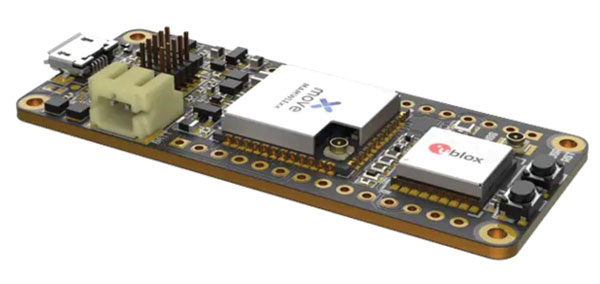
The Cicerone LoRa/GNSS board is a high-performance, low-power, Arduino MKR-compatible development board based on the u-blox MAX-M10S GNSS module and the MAMWLE LoRa module. It delivers high-performance GNSS, long-range wireless connection, and high-performance processing in a low-power solution for optimal battery life. The board allows users to build tracking applications worldwide with meter-level accuracy and to communicate long-range, low-power data via LoRaWAN. The integrated Li-Po charging circuit enables the Cicerone board to manage battery charging through the USB port. It has a compact 63 mm x 25 mm form factor and is compatible with all Arduino MKR shield boards. These boards all share a common pinout to enable developers to easily add expansions with minimal software changes.
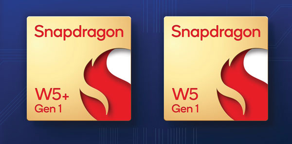
The Snapdragon W5 Gen 1 and W5+ Gen 1 platforms are designed to advance ultra-low power and breakthrough performance for next-generation connected wearables with a focus on extended battery life and premium user experiences. They incorporate innovations including low power islands for GNSS, Wi-Fi and audio; ultra-low power Bluetooth 5.3 architecture; and low power states such as Deep Sleep and Hibernate. New enhancements to the flagship Snapdragon W5+ platform offer 50% lower power, 2x higher performance, 2x richer features, and 30% smaller size, compared to the previous generation. The purpose-built platform is comprised of a 4 nm-based system-on-chip and 22 nm-based highly integrated always-on co-processor. By using these platforms, manufacturers can scale, differentiate and develop products faster in the continuously growing and segmenting wearables industry, Qualcomm said. Qualcomm also announced two reference designs from Compal and Pegatron, which showcase the capabilities of the platform and the company’s collaboration with ecosystem partners, helping customers develop products faster.
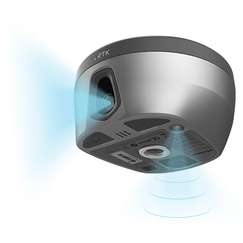
The pocket-sized vRTK GNSS real-time-kinematic (RTK) receiver is equipped with dual cameras to enable non-contact image surveying. It also has a nine-axis IMU module with auto installation for tilt surveying. Visual positioning technology combines imagery with high-precision positioning equipment, allowing users to obtain the location of the target from a distance. The Live View Stakeout function improves stakeout speed, while non-contact measurement greatly improves the usable range of GNSS. The vRTK receives 1,408 channels (GPS, GLONASS, BeiDou, Galileo, QZSS, IRNSS and SBAS). A new generation of GNSS engine supports the new frequency points B1C, B2a and B2b RTK decoding of BeiDou-3 satellites.
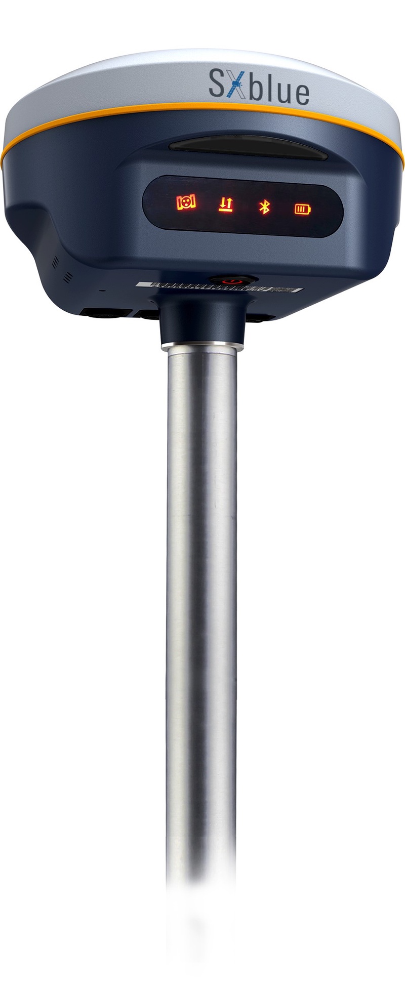
The SXblue SMART features an engine capable of tracking all-in-view GNSS signals, with interference mitigation and optimization for handling a wide frequency band. Weighing 850 g including battery, the SXblue SMART is compact and rugged. Its radio link is based on the Farlink protocol that allows a range of up to 8 km while reserving a wide bandwidth for transmission of real-time kinematic (RTK) data. In addition to a tilt sensor for measurements in hard-to-reach places, the SXblue SMART features a high-performance attitude measurement module that can detect and measure movement of the device. Also integrated are an inertial measurement unit and a thermometer for monitoring and controlling its internal temperature.
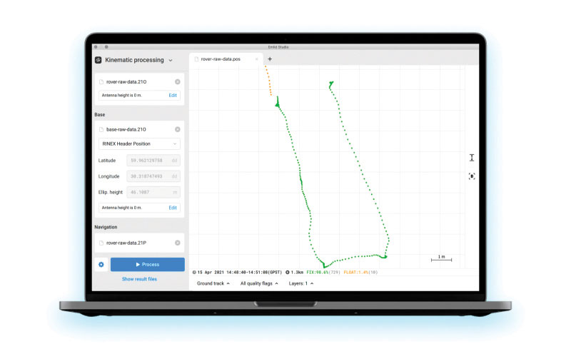
Emlid Studio is a new post-processed kinematic (PPK) application designed specifically for post-processing GNSS data. It allows users to convert raw GNSS logs into RINEX, post-process static and kinematic data, geotag images from drones (including DJI brand), and extract points from survey projects completed with Emlid’s ReachView 3 app. With Emlid Studio, users can post-process data recorded with Emlid Reach receivers and other GNSS receivers or NTRIP services. Post-processing requires RINEX observation and navigation files. Raw data in UBX and RTCM3 format also can be used through conversion.
The P1 GNSS receiver has a high-precision module that tracks GPS, GLONASS, BDS, Galileo, QZSS and SBAS to deliver centimeter-level real-time kinematic (RTK) accuracy even in harsh environments. It is also equipped with an anti-jamming and anti-spoofing algorithm. The P1 GNSS receiver has integrated the GNSS module and GNSS antenna while keeping the device as small as a smartphone, which makes it portable enough to be worn around the neck or placed in a pocket. With 4G/Bluetooth communication, the P1 supports real-time positioning data transmission, providing users with a stable correction data steam and positioning data uploads. The P1 also can be mounted on a pole.
Nuwa surveying smartphone app version 2.3.3.2 has vector map import and digital surface stakeout. The Nuwa app runs on Android and is reliable and easy to operate. It has rich and powerful functions that can help surveyors complete measurements more efficiently and accurately. The app is designed to work with the David and Oscar GNSS receivers from Tersus GNSS, plus other receivers that support NMEA-0183. Features include the ability to configure base, rover and static surveys; graphical interface with background map (online/import); CAD stakeout, road stakeout and earthwork; data management (import/export multiple formats); and Bluetooth and USB connection support.
Version 3.2 of the survey application 1Edit allows the use of Web Maps (WMS) to be used as background layers, making it easier for surveyors to identify assets and changes in context. It provides easier configuration of background maps and supports hybrid working practices for surveyors. Where offline background maps are required, 1Edit supports multiple raster files and handles large image files, providing visual context for geospatial data when there is no data signal. Enhanced support for complex geometries increases efficiency as features with multiple parts share common attributes and IDs.
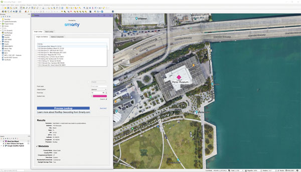
The Smarty U.S. Geocoding QGIS Plugin provides an easy way for users of the software platform to validate, standardize, and convert addresses to their latitude and longitude coordinates (geocodes). The plugin allows manual address entry as well as batch geocoding via CSV. It features a 95% match rate with the actual rooftop and parcel, as well as providing sub-address geocoding that can match secondary addresses such as apartment units and office-suite rooftops in building. The free plugin also includes supplemental metadata useful for many geographic information system (GIS) purposes.
Datasets for the United States, UK, Canada, Australia and Europe
Photo: Maptitude
Maptitude 2022 is a major release of the geographic information system (GIS) and mapping software. It includes up-to-date, accurate data encompassing expenditure, geodemographic segments, gross domestic product, medical and banking locations, branded business locations, traffic counts, building footprints, address points and financial assets, as well as the tools to leverage this information to improve the location intelligence of organizations in markets such as healthcare, franchising, communications, logistics, retail, real estate and banking.
The Mesa Pro rugged tablet features 11th-generation Intel Core processors, a Windows 11 operating system, device customization options, a large sunlight-readable display and the “Juniper Rugged” company design. Standard Mesa Pro units come with an 11th Gen Intel Core i5 processor and 16 GB of LPDDR4x RAM. Core i7 and Celeron versions are also available. Each Mesa Pro configuration offers powerful performance and allows users to select the computing performance that fits their needs and budgets.
Data fusion across multiple data sources, including ADS-B
Photo: Vigilant Aerospace
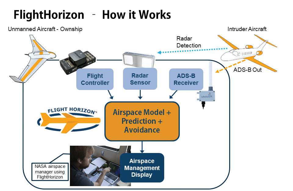
FlightHorizon COMMANDER is a situational awareness and safety system for UAV airspace management. The system provides airspace managers with either a 2D or 3D view of all aircraft in the selected airspace using a combination of sensors and data sources to create an airspace safety picture for pilots, airspace managers and command centers. The system is based on an exclusively licensed NASA patent and prototype that has been used in extensive flight testing. FlightHorizon COMMANDER functions as a visualization tool for airspace management, an active situational awareness tool, and a detect-and-avoid system that enables unmanned aircraft to avoid other aircraft and keeps drone pilots and airspace managers aware of the location and air traffic around their UAS and in their airspace.
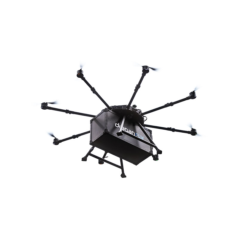
The Draganfly Heavy Lift Drone is a versatile, multi-rotor unmanned aerial vehicle designed to enhance deliveries and flight times. Compatible with a variety of interchangeable payloads, the heavy-duty drone can carry more and fly longer than the typical professional drone. It has a payload/cargo-lift capacity of 30 kg (67 lbs) and up to 55 minutes of flight time. The industrial UAV handles heavy winds and high elevations with ease. Its lifting capacity permits flexibility in carrying large high-end sensors such as hyperspectral and bathymetric lidar to conduct large-area surveys.
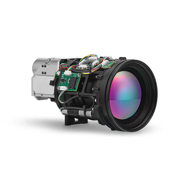
Allows rapid MWIR integration for commercial, industrial and defense applications
Photo: Teledyne FLIR
Part of the Neutrino IS series, the Neutrino LC CZ 15-300 is a new mid-wavelength infrared (MWIR) camera module with integrated continuous zoom lenses. Designed for integrated solutions requiring crisp, long-range MWIR imaging, the camera offers size, weight, power and cost (SWaP+C) benefits to original equipment manufacturers (OEMs) and system integrators for airborne, unmanned, C-UAS, security and targeting applications. The LC CZ 15-300 offers high performance, 640 x 512 high-definition MWIR imagery and 15 mm to 300 mm zoom capability for ruggedized products requiring long life, low power consumption and quiet, low-vibration operation. The camera module and lens are designed for each other, providing optimal performance.
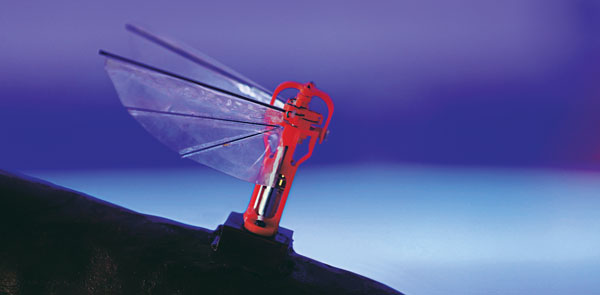
A miniature drone with flapping wings was demonstrated at the Teknofest Black Sea aviation and defense industry event, which took place Aug. 30 to Sept. 4 at the Samsun Çarşamba Airport. With its low detectability, the nano drone is being developed to perform reconnaissance and surveillance missions. It is still in research and development.
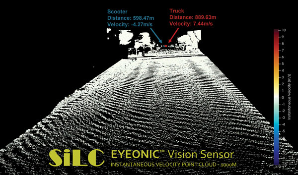
The Eyeonic Vision Sensor can perceive, identify and avoid objects at a range of more than 1 kilometer. The sensor is a frequency modulated continuous wave (FMCW) lidar transceiver that uses a silicon photonic chip. Long-range visibility is a requirement for autonomous vehicles, which require sufficient awareness to evade obstacles at highway speeds. This capability requires vision sensors to provide millimeter-level accuracy and depth at instantaneous velocity. The highly detailed and ultra-long-range information from the Eyeonic Vision Sensor enables robots to classify and predict their environments. The sensor is designed to be integrated into autonomous vehicles, security solutions and industrial robots.
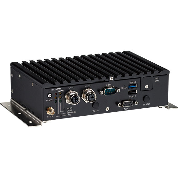
The nROK 1030 is a compact, rugged entry-level vehicle computer with an advanced GNSS receiver. The u-blox NEO-M9N module supports GPS, GLONASS, Galileo, BeiDou and QZSS signals. An Intel Atom x6211E dual-core processor 1.3 GHz/3 GHz (burst) is designed for harsh in-train environments. Its fanless, compact design is suitable for vehicles with limited space. The nROK 1030 has onboard CAN 2.0B for vehicle diagnostics and driver behavior management. WLAN Wi-Fi 6/6E/Wi-Fi 5 and WWAN 5G NR/LTE wireless data connectivity is optional. The nROK 1030 is flexible to meet the demands of various rolling-stock applications, such as wireless gateway, infotainment and digital radio data/voice transmission systems.
According to Fact.MR, a market research and competitive intelligence provider, the global surveying and mapping services market was worth US$9 billion in 2021 and is expected to expand at a CAGR of 3% during the forecast years of 2022-2032.
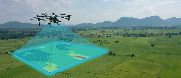
The survey and mapping industry has significantly benefited from drone technologies, because UAVs are less expensive and more accessible compared to traditional methods. Conventional surveying methods require rental aircraft and trained pilots, along with attached recording instruments — a costly and resource-intensive process. The introduction of UAVs has substantially created a future opportunity for surveying and mapping services to gather spatial information in a tighter structure. This also allows the collection of geospatial information with easy storage, processing and sharing capabilities.
For instance, in May 2022, India-based software company PDRL introduced a software-as-a-service platform — DroneNaksha — under the Svamitva Yojana scheme by the government of India for mapping land parcels using drone technology across the country. Similarly, in March 2022, Australia-based Emesent introduced Hovermap ST autonomous drone lidar mapping and surveying payload.
The integration of advanced technologies such as Wi-Fi, first-person view cameras, and GPS technology to make UAVs highly flexible and eliminate the need for a skilled pilot is expected to stimulate the demand for drones for survey and mapping activities, thereby driving market expansion.
Key Takeaways
The global surveying and mapping services market is projected to expand at a CAGR of 3.4% and reach US$13 billion by 2032.
Over the 2017-2021 historical period, the market evolved at 3.2% CAGR.
Forestry and agriculture account for a leading share in the market at a valuation of US$1.80 billion in 2021.
North America and East Asia account for leading shares in the global mapping services market at 24% and 32%, respectively.
The U.S. Department of Transportation’s Federal Aviation Administration (FAA) has awarded $2.7 million to support research on how drones can assist in disaster preparedness and in emergencies.
“Every second counts in an emergency, and this funding will allow drones to safely and more quickly deploy in moments when minutes matter,” said Acting FAA Administrator Billy Nolen.
A policeman works with a drone. (Photo: FAA)Photo:
The research will explore the use of drones in providing effective and efficient responses to different natural and human-made disasters. It will address coordination procedures among drone operators from federal agencies as well as state and local disaster preparedness and emergency response organizations. The five universities and their award amounts are:
University of Vermont: $1,195,000
University of Alabama Huntsville: $828,070
New Mexico State University: $400,000
North Carolina State University: $200,000
Kansas State University: $145,000
Today’s announcement is the third round of Alliance for System Safety of UAS through Research Excellence (ASSURE) grants, which brings the total to 20 grants valued at $21 million for Fiscal Year 2022.
The ASSURE Center of Excellence is one of six the agency has established to help advance technology and educate the next generation of aviation professionals. Research conducted through ASSURE is focused on helping the drone community safely grow and integrate into the nation’s airspace.
Earlier in 2022, Transportation Secretary Pete Buttigieg outlined six key Innovation Principles the department will apply when fostering transportation technologies. While continuing to commit to the highest standards of safety across technologies, these awards demonstrate the department’s commitment to exploring ways to leverage innovation to help communities and public-sector partners through experimentation.
More than 850,000 recreational and commercial drones are in the active drone fleet, and that number is expected to grow.
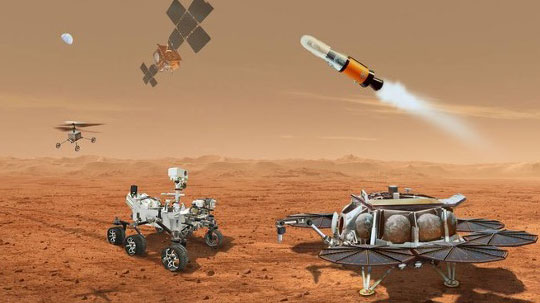
NASA and the European Space Agency (ESA) have been cooking up a way to get some of Mars back to Earth, so that samples can be analyzed in detail — just like the rocks the astronauts brought back during the Apollo missions, which gave us a deeper understanding of our Moon.
The Perseverance rover already on Mars has been seeking promising areas to investigate that might provide evidence of ancient past life, with the help of the Ingenuity helicopter drone. Recently, the two worked together to drive the rover to an old river delta, expected to be a prime location where such samples could be found.
The rover has been drilling and saving rock and dirt samples in onboard storage tubes. The difficulty is that getting them back to Earth requires another major undertaking.
Returning the Samples
Termed the “Sample Return Mission,” the two space agencies have been discussing for months how best to bring the samples back, and have now refined an approach. Given that Perseverance has been so good at the job it was given, the NASA/ESA team has decided that the rover should be used for the return mission in 2030 when things would be in operation on Mars. (We’re not sure if the warranty sticker on Perseverance will still be valid in 2030, but if past performance is an indication, all the rovers have significantly outlived their initial design lives.)
Its partner Ingenuity has graduated from proving it can fly in the thin Martian air to actually scouting routes for the large rover. Because Ingenuity has proven reliable and capable of traveling significant distances, NASA and ESA have decided that two new helicopter drones will become part of the return mission. They will be based on the successful Ingenuity design, but will be fitted with wheels, one on each of the four landing legs, to enable movement on the ground.
They will also be fitted with a device which is capable of picking up and carrying a sample tube. Since the prototype drone helicopter was designed to be as light as possible, this infers a substantial increase in lift capacity will be required. The original mission included a sample-collection rover, but this task will now be assigned to Perseverance, with the two sample-carrying helicopters acting as backup, if needed.
An earlier concept had the rover dropping sample canisters behind it as it progressed around the surface for subsequent pick up. This concept appears to have been shelved for the moment. Keeping the canisters onboard the rover throughout perhaps simplifies transfer to the return lander.
This NASA return sample concept illustration includes wheeled helicopters. (Image: NASA/JPL-Caltech)
The Mars Ascent Vehicle would then carry the samples into orbit, to a waiting Earth Return Obiter, where the samples would be transferred to a return system for onward transit and atmospheric re-entry to Earth. Some of these details are a little sketchy, but there sure are a lot of moving (autonomous, robotic?) parts. This, of course, means a lot of opportunities for something to go wrong. No doubt continuing refinement of the mission will reduce the risks. The Jet Propulsion Lab (JPL) and AeroVironment designed and built Ingenuity — they may face some challenges developing the successor helicopter drones.
Meanwhile, Here on Earth…
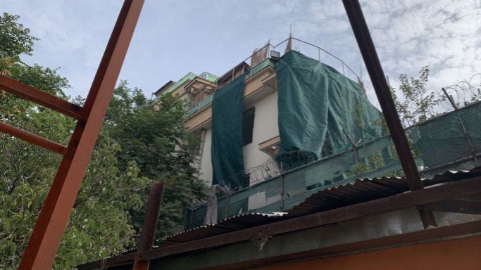
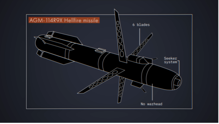
Drones led the news Aug. 1, when President Biden announced the killing of Ayman al-Zawahiri in Kabul, Afghanistan. Al-Zawahiri topped the U.S. 9/11 wanted list, and his removal was all about the offensive use of drones. Presumably fired from a General Atomics Reaper variant drone at quite some altitude, two Hellfire AGM-114R9X “knife bomb”missiles took out al-Zawahiri as he stood alone on the balcony of a home in Kabul.
This means that video/infrared from high altitude was sufficiently clear to determine that the man was alone on the balcony, presumably confirming information on the ground that his family was elsewhere. So long-distance, high-level authorization was then granted to fire on him in a foreign country now run by the Taliban.
Suspected damage at the al-Zawahiri house in Kabul. (Photo: Secunder Kermani/BBC News)
To minimize inadvertent casualties, the Hellfire R9X missile was used, which lacks explosive armaments. The weapon is a nasty piece of work, weighing ~100 lb with an inert payload, and fitted with six long knives that deploy before impact. This missile has previously been used in perhaps 11 other instances to take out terrorist individuals and minimize collateral damage.
Bladed R9X missile lacks a warhead (Image: Newsy/Bellingcat)
This is another instance of how the U.S. use of military drones has become less devastating, but is still very deadly to the specific target.
To Sum Up
We’ve taken a quick glimpse at how NASA and ESA are planning more drones for the surface of Mars, and a much more aggressive use of drones here on Earth.
A roundup of recent products in the GNSS and inertial positioning industry from the June 2022 issue of GPS World magazine.
SURVEYING & MAPPING
Base/Rover
For survey-grade GNSS accuracy anywhere
Photo: Bad Elf
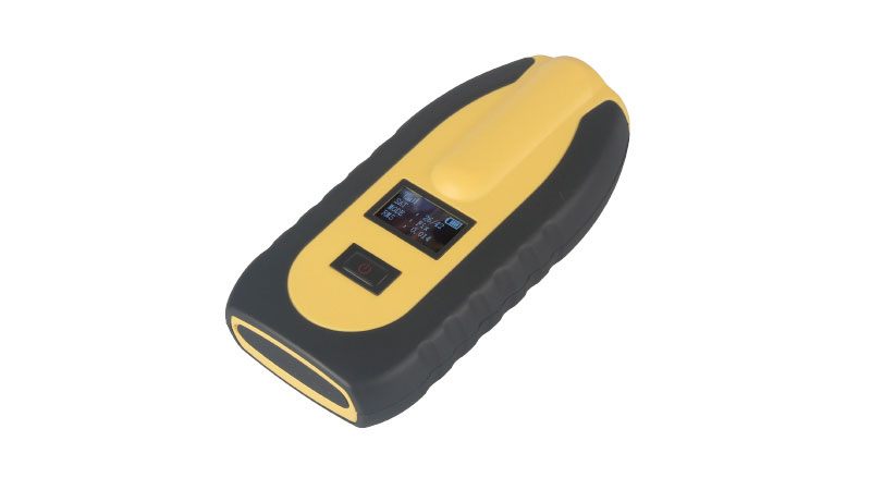
A base/rover feature built upon the Flex GNSS receiver brings affordable centimeter-level accuracy to surveyors and geospatial professionals working anywhere in the world. The solution consists of two Flex GNSS receivers and two UHF radios, allowing customers to perform high-accuracy field data collection in areas where traditional real-time kinematic (RTK) corrections or cellular coverage is not available. Existing Flex customers can upgrade by adding Flex radio kits (pictured). The Bad Elf Flex enables data collection either as a standalone receiver or paired with apps on iOS or Android phones and tablets.
The Leica Pegasus TRK reality-capture mobile-mapping system features artificial intelligence (AI), autonomous workflows and intuitive interfaces. To comply with privacy regulations, its AI can identify and blur identifiers, such as people and vehicles, in real time. Features include advanced dynamic laser scanning and an expandable imagery system for recording, measuring and visualizing. It enables long-range mobile mapping for asset management, road construction, rail, critical infrastructure, utilities and more. The system also can create high-definition basemaps for autonomous vehicles.
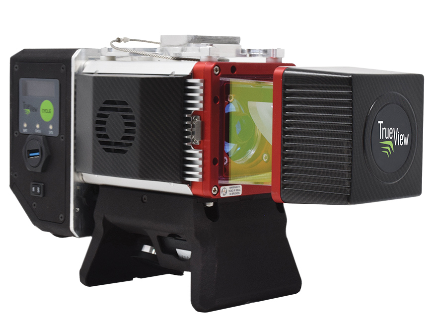
The True View 645/650 is the latest 3D Imaging System (3DIS) from GeoCue. Combined with the True View EVO data-processing software suite, it includes the full post-processing software workflow and directly integrates with Applanix POSPac. EVO supports the creation of project deliverables including ground classified point clouds, surface models, contours, digital elevation models (DEMs), volumetric analysis and wire extraction. The system delivers colorized lidar deliverables with accuracy better than 3 cm root-mean-square-error (RMSE) for the True View 645, and better than 2 cm for the True View 650.
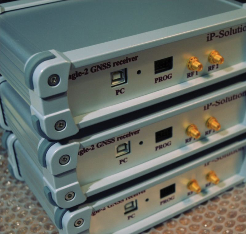
The Eagle-2 works with software-defined receivers in real time or records GNSS signals for post-processing. For post-processing, Eagle-2 supports most third-party receivers, such as MATLAB and C/C++ receivers. The front end allows a user to work with two perfectly synchronized channels connected to two antennas. The Eagle-2 supports GPS, Galileo, GLONASS , BeiDou, QZSS and SBAS.
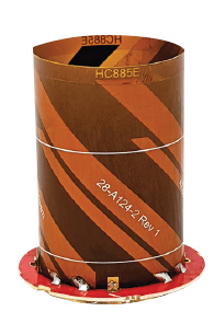
The housed HC885XF and embedded HC885EXF dual-band eXtended Filtering (XF) antennas receive GPS/QZSS L1/L5, GLONASS G1/G3, Galileo E1/ E5a/b, BeiDou B1/B2/B2a and L-band corrections services. They have been tuned to provide optimal support for the entire L1/G1/E1/B1/L-band correction and L5/G3/E5/B2 bands. The housed version, HC885XF, weighs ~42 g and is enclosed in a robust, military-grade IP67 plastic enclosure. The embedded version, HC885EXF, weighs ~8 g and is easily mounted with an embedded helical mounting ring.
Sets performance benchmarks for harsh environments
Photo: Analog Devices
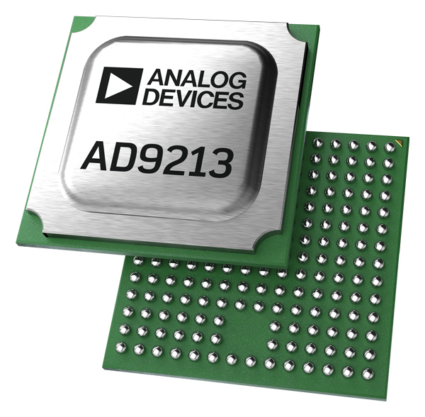
The AD9213S-CSH is a highly integrated RF analog-to-digital converter that handles 12-bit, 10.25-giga-samples per second. It is the company’s fastest ADC available for the space environment. The AD9213-CSH enables the next generation of software-defined systems for satellite communications, radar and remote sensing. The high sample rate and integrated post-processing enable further performance gains for narrow-band applications.
Skyward has published a free ebook, Adding Drones to the Enterprise, to provide guidance on establishing a corporate drone program. According to Skyward, the most efficient and effective drone programs are the lowest risk and most compliant. Topics covered include how to present the business value of a drone operation to corporate executives; how risk managers can optimize the workflow to ensure maximum safety; best practices for risk mitigation and regulatory compliance; tips for collaborating with legal and compliance teams on a general operating manual; and how to provide full transparency to corporate stakeholders.
DJI’s all-in-one solution for professional drone operators includes the DJI Matrice 30 (M30) drone integrated with DJI FlightHub 2 fleet-management cloud software and DJI Dock for autonomous docking and recharging. The integrated solution is suitable for Enterprise drone users such as public safety agencies, infrastructure inspectors and energy operators. The M30 model is designed for rugged professional uses, while the fact that it fits in a backpack makes transportation and setup fast. The DJI Dock is an autonomous takeoff, landing and charging station allowing fully automatic, programmed flights with the DJI M30 Series (Dock Version). After setup, the fully charged M30 drone can take off from the dock through FlightHub 2 programmed automatic missions anywhere within a seven-kilometer radius.
The AlphaAir 1400 (AA1400) and AlphaAir 2400 (AA2400) lidar systems are lightweight, compact airborne scanners easily installed on various UAV platforms or small survey aircraft and helicopters. They are adapted to high-density point-corridor mapping applications, day or night, under leaf-on and leaf-off conditions or with dense vegetation to provide reliable results. Combined with industrial-grade GNSS receivers and high-precision inertial measurement units (IMUs), the AA1400 and AA2400 provide 2 cm to 5 cm survey-grade accuracy. They also integrate Riegl VUX lidars with waveform-lidar technology, allowing echo digitization and online waveform processing.
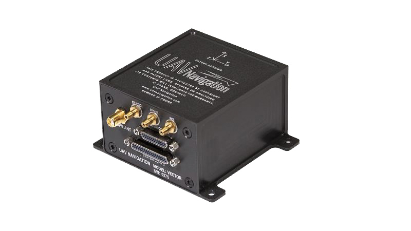
The VECTOR-600 is a robust, dependable autopilot with built-in physical and logical redundancy, allowing it to survive all individual sensor failures while maintaining accurate estimates of attitude and position. It works for fixed-wing, rotary-wing and vertical-take-off-and-landing UAVs. It provides exceptional performance in GNSS-denied environments and when there is a jamming threat. The VECTOR-600 features high quality components and an electromagnetic-resistant design tested to MIL-STD 461.
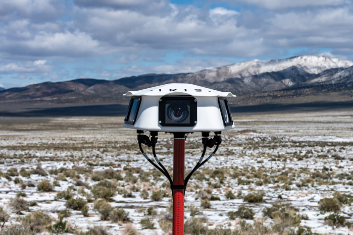
Casia G is a ground-based detect-and-avoid surveillance solution that provides 360° optical detection with alerts. It enables operators to avoid both cooperative and non-cooperative aircraft for safe beyond-visual-line-of-sight (BVLOS) flight. Casia G creates a perimeter of monitored airspace for UAVs to perform work safely, without additional payload. It is suitable for operations in fixed or temporary locations, supporting drone-in-the-box operations and augmenting or replacing human visual observers. Casia G sees the entire sky, with uniform probability and resolution, 10 times per second, covering a majority of small UAS use cases.
Plus: UAVs in Ukraine, vineyard protection and a royally awesome light show
Taser-equipped drones
We hear of mass shootings in schools, and this week on a crowded street in Philadelphia a school adviser was among those killed. Everyone continues to be outraged, but as we wait for any sort of positive, preventive action by our leaders, an idea from a drone developer was shut down before it even got out of the company.
Axon taser drone concept. (Photo: Axon)
Axon Air supplies Tasers and body cameras to police forces, and last year someone came up with the idea of loading a drone with a Taser so that it could find and suppress a gunman in a school. There are a lot of problems with the idea, and Axon’s own internal artificial-intelligence board nixed the idea.
Doors were the board’s primary concern. What happens if something triggers a drone to Taser kids in the classroom or hallway? Could autonomous drones or even multiple intelligent cameras detect an actual weapon of any description, and set off an automated response?
We use metal detectors on entry to some schools to deter carrying weapons to class, but how about recognizing carried weapons in the school? To even attempt an automated drone response, you would need multiple Taser-equipped drones in all areas of a school, as well as time to test and verify that any autonomous response would work correctly.
Could anything along these lines be something we might consider in any way?
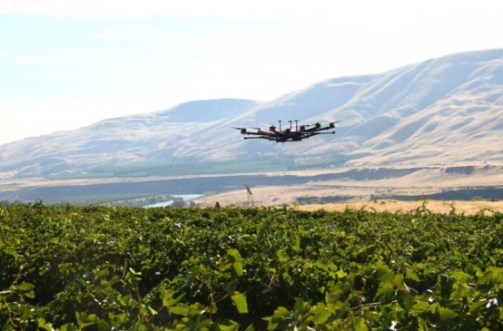
Keeping watch at vineyards
A team at Washington State University (WSU) has come up with a new twist on an old idea. Hawks have been trained effectively in the past to chase off flocks of birds on or around runways at airports or to protect crops. Now WSU has developed a system that uses intelligent cameras to detect birds, and which is then able to dispatch drones to the invaded area to chase off the birds.
The system has been tested to protect local grapevines. Bird fruit losses were actually reduced by ~50% following manual drone flights, which also reduced the number of bird invaders four-fold.
Manually flown drone patrols over vineyard. (Photo: WSU Agricultural Automation and Robotics Lab)
Nevertheless, birds can learn over time how to get round such deterrence, so WSU proposes disguising drones as predator birds and arming them with distress calls or raptor-attack behavior. WSU is looking for wine-industry support to develop this approach into a feasible, deployable solution.
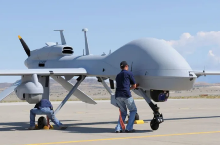
Grey Eagles might fly in Ukraine
The United States is considering providing Grey Eagle UAVs (the Army version of the Predator) to Ukraine — the first time a relatively high-tech drone with weapon-carrying capability would be supplied for the Ukrainian conflict.
The Grey Eagle can carry up to eight hellfire missiles, fly for 30 hours at relatively high altitude, and gather masses of surveillance information — a formidable, front-line weapon/reconnaissance system. Four UAVs are envisaged; missiles would not be included in the first round, but would likely come soon after.
Grey Eagle drone (Photo: General Atomics)
Th Grey Eagle UAV system usually requires months of advanced training, but the Ukrainian forces have already been operating the smaller missile-carrying Turkish Bayraktar-TB2, so training may be reduced to a few weeks for operational necessity. Meanwhile, the sale must first be approved by Congress, so nothing is yet certain.
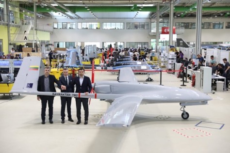
Officials with a donated TB2 drone. (Photo: Baykar)
Before the war with Russia, Ukraine purchased up to 30 TB2 drone systems, and many have seen action in the current conflict. A crowdfunding effort by a TV station in Lithuania gathered enough cash to buy yet another TB2 to help Ukrainian forces stay in the fight.
However, Baykar, the Turkish manufacturer, declined the sale, instead offering to donate a TB-2 so that the Lithuanian funding could go toward humanitarian aid for the Ukrainian people.
Meanwhile, in Estonia the Internal Security Service (KAPO) arrested a man leaving the country who is suspected of supplying commercial drones to the Russian forces.
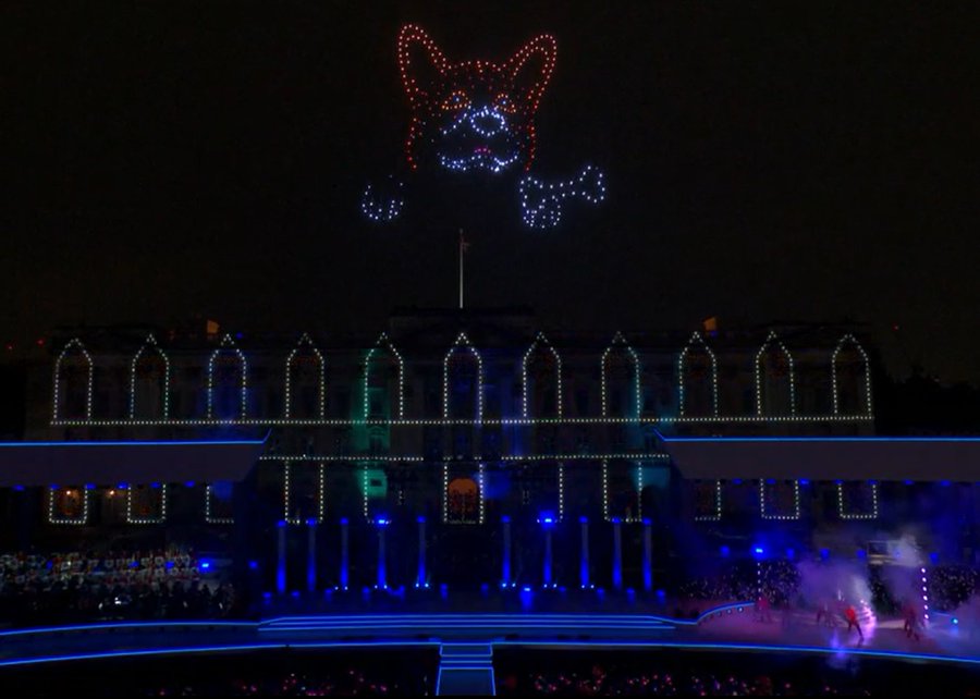
Photo: Platinum Jubilee Committee
Honoring the Queen
Finally — on a much lighter, respectful note — a drone light show was a big hit over Buckingham Palace in London on the occasion of the Platinum Jubilee concert for Queen Elizabeth II.
The queen has been on the United Kingdom’s throne for 70 years. To celebrate, the Brits hosted a major shindig. As part of a concert held outside Buckingham Palace, 400 lightshow drones from SkyMagic flew above the palace. The drones created various designs, showing the message “Thank you, ma’am”, a Corgi, a handbag, a teapot pouring into a teacup, guards in busbies, and a figurehead postage stamp — all good fun received in good spirit by a huge milling crowd.
Food for thought
To sum up, maybe it’s not such a good idea to have drones equipped with Tasers in schools, but perhaps it’s an idea we could build on to better protect our kids.
Trained, autonomous drones that take off and chase birds when they descend on vineyards — could this be a better solution than low-slung netting?
The war in Ukraine rages on. Not only the West, but also some Eastern countries pitch in with support.
Finally we saw a drone light show for the queen during the Jubilee celebration of her 70 years reign. We’re seeing a lot of smart drone potential out there.
The Drone Tournament has relaunched following the COVID pandemic, and will take place June 8-10 in Helsinki, Finland.
In the competition, drones will compete to prove precision-control drones over land and sea. GNSS companies Septentrio, Spirent and u-blox will take part.
Sponsored by Ultrahack, the competition seeks to boost use of drone technology, including for 5G networks and satellites. The challenges are especially related to landing and precision flight in demanding and changing environments. Contestant drones will use a wide spectrum of navigation and sensor technology, including GNSS.
U-blox, Spirent and Septentrio are offering their GNSS technology for the participants.
Septentrio and u-blox will provide GNSS services that teams can use to increase performance as they land their drones on a moving boat. To help improve performance, Septentrio and u-blox will provide access to data streams from a base station on the shore and on the boat.
The streams will provide raw observations in RTCM3 format via NTRIP (which can be used to compute a real-time kinematic, or RTK, position of the drone). The stream from the boat will also provide position, heading and speed of the boat over an IP connection in NMEA or binary format.
Using these streams can help to obtain an RTK solution on the drone or to know the relative position between the drone and the boat.
The winners will receive monetary prizes and the possibility of negotiating commercial agreements for further development of their solutions.
Last month we attempted to provide an overview of the issue concerning Federal Communication Commission’s (FCC) licensing of C-Band radio spectrum, the subsequent fielding of wireless service for 5G phones and the Federal Aviation Administration’s (FAA) announcements that potential interference could be possible between 5G signals and C-Band radio altimeters on commercial aircraft.
Not a big deal most people might say, as faster and improved phone and data messaging on their smartphones begins to kick in, while wireless companies continue roll-out of the new 5G service. But wait – don’t some of these people fly out on vacation and then back and land at local airports, and many of us fly around the US to visit friends and family, or each week shuttle around the country doing fly-in/fly-out business?
Well FAA and the wireless companies have largely collaborated during 5G service roll-out, and the FAA has been rapidly clearing a good number of rad-alt (radio altimeter) equipped aircraft to continue regular operations into most airports. And it seems that wireless companies have limited 5G fielding around some US airports by reducing transmitted power and/or limiting the density of 5G towers.
But where are we now? Seems some aircraft equipped with some types of rad-alt can fly into some airports – the FAA published a list for aircraft operators and pilots identifying who can do what and where. They also published several ADs (Airworthiness Directives) which limit several aircraft types from flying into certain airports, ‘prohibiting certain operations, which require radioaltimeter data to land in low visibility conditions, when in the presence of 5G C-Band interference’. For any aircraft passengers flying into LaGuardia on a foggy day or Boston when ice-fog hangs in the air – low visibility landing capability on modern aircraft is a blessing and a wonder which allows us to travel, even in bad conditions.
Seems that, typically – ‘many systems on (XY Type) aircraft rely on the radio altimeter, including autothrottle, ground proximity warning, thrust reversers and Traffic Collision Avoidance System,’ says one recent FAA AD.
That’s a whole bunch of critical systems which help an aircraft land. Many experts over many years have spent whole careers supporting the process of developing safety systems for auto-land and those which assist in the manual landing of aircraft. And the FAA and other agencies around the world have made every manufacturer prove and prove again that these systems work and work extremely, reliably, well.
Not that I’m against 5G – I have a 5G phone and I’m eagerly waiting for 5G applications to use on my phone. – the service seems to be very fast when in an area where 5G has been fielded. There are some wireless companies who have decided that 5G can by-pass cable in the distribution of TV channels – this is good stuff! Let’s have more of it!
But why on earth do we need to even partially compromise any aircraft systems which safely land aircraft?
Japan and France have been cited as counties in which 5G has not had any impact on the very same aircraft and their operations with which the FAA has found problems. Well, except those countries seem to have taken steps in the fielding of 5G which have protected their aircraft operations. The FAA quotes several mitigations used in those countries:
• Lower power levels
• Antennas adjusted to reduce potential interference to flights
• Different placement of antennas relative to airfields
• Frequencies with a different proximity to frequencies used by aviation equipment
Let’s hope that FAA’s intense efforts to test and clear rad-alts under the simulated intensity of C-Band interference around airports will continue unabated and that soon we aviation nuts will begin to breath more easily.
And let’s hope that the wireless companies cooperation, acceptance and mitigation steps – for which the whole aviation community is extremely grateful – that these very positive steps will directly lead to the whole issue fading away over time as old news.
And then a few words about ‘the war‘ which Russia just began against its neighbor and previous member of the USSR – Ukraine has been independent from Russia since the USSR ‘dissolved’ (Wikipedia) in 1991.
Ukrainians are pretty resilient and the news today is that a woman in Kyiv brought down a Russian drone by throwing a jar of pickles at it from her (high-rise?) balcony. This story of course isn’t verified, but it’s a small lightness in a very grim situation.
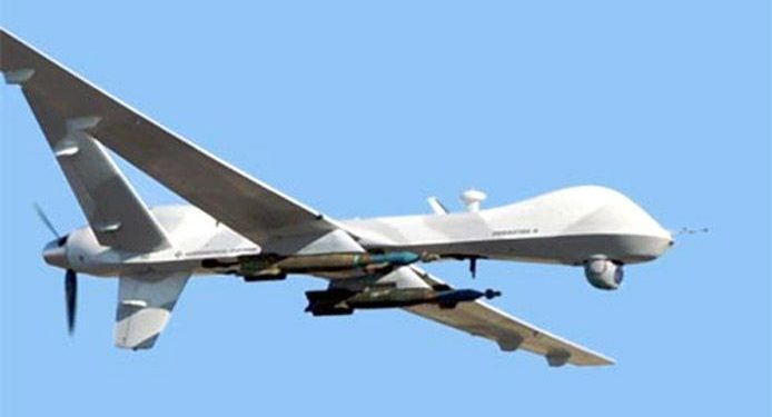
General Atomics armed MQ-9 Reaper (Militaryanalizer.com)
And its reported that Poland just placed an urgent operational requirement for armed MQ-9 Reapers in order to better protect its Eastern border with Ukraine. The border is around 530 miles long and is the main crossing point for the thousands of refugees fleeing the Russian onslaught. Poland has apparently already taken in almost a million people seeking safety.
Drones are now part of modern warfare and both East and West have pretty sophisticated, capable, weapon-carrying unmanned aircraft. But they also usually carry highly accurate satellite navigation and laser-guided weapons which may minimize unintended casualties – unless casualties are exactly what the Russians are after.
Really sad state of affairs which we all may still follow in detail through news reports, even though Russia has completely shut down social media and virtually outlawed on-the-ground news reporting.