NextNav’s Pinnacle 911 will deliver Z-axis capabilities with floor-level accuracy for wireless 911 calls in more than 4,400 cities and towns across the United States.
NextNav has entered into an agreement with one of the nation’s largest wireless carriers, not yet named, to deliver vertical location for Enhanced 911 (E911), using NextNav’s Pinnacle 911.
Pinnacle 911 leverages the barometric sensors already available in phones, tablets and other devices to deliver “floor-level” altitude measurements that exceed the FCC mandate for 3-meter accuracy. The Pinnacle service compares device data to local conditions, subtracting the weather and other factors to leave behind a highly accurate altitude measurement.
NextNav altitude stations create a hyperlocal model of environmental conditions. The precisely surveyed, high-density network delivers “floor level” real-time altitude data nationwide.
NextNav’s dedicated, managed network makes Pinnacle available throughout metropolitan areas, providing comprehensive coverage that scales to meet a variety of use cases.
The delivery of vertical location to public safety answering points (PSAPs) nationwide will improve emergency response in the United States. It enables first responders to accurately locate wireless 911 callers in multi-story buildings, enhancing both safety and response times, and helping to save lives.
With NextNav’s Pinnacle 911 reaching more than 4,400 cities and towns in the United States, including 90% of buildings above three stories, implementation of the service will exceed the Federal Communication Commission’s (FCC) Z-axis requirement for nationwide E911.
“For over two decades, one of public safety’s key needs has been 3D geolocation information — especially floor-level vertical location,” said Ganesh Pattabiraman, CEO of NextNav. “Partnering with one of the nation’s largest wireless carriers to deliver precise, Z-axis information will not only improve geolocation information for PSAPs, but save lives by reducing emergency response times by more than 80%. This adoption of our Pinnacle technology for 911 marks a historic step forward for communities around the nation, and public safety as a whole.”
In an independent evaluation by the Cellular Telecommunications and Internet Association commissioned by the FCC, Pinnacle was able to deliver floor-level accuracy (defined as ±3 m) 94% of the time, consistently exceeding the 80% benchmark set by the FCC.
NextNav’s Pinnacle service enables applications and technologies that rely on precise altitude data across industries, including public safety, mobile apps and gaming, lone worker tracking as well as out-of-home retail experiences.
NextNav’s extensive list of existing partners and customers includes AT&T FirstNet, Intrepid Networks, 3am, TRX Systems, Qualcomm, Bosch, Unity and Unreal Engine.
In separate letters to members of the House of Representatives and the Senate, seven companies and a non-profit urged Congress to support alternative positioning, navigation and timing systems (PNT) with the “necessary funds and other appropriate policy tools.”
The letters focus on and endorse the system-of-systems approach outlined in the Department of Transportation’s (DOT) recent report to Congress on the results of its GPS Backup Technology Demonstration. The report found an adequate and robust American PNT system should include space-based L-band signals, low-frequency (LF) and ultra-high-frequency (UHS) signals, and fiber connections between the terrestrial LF and UHF transmitters.
“Our country depends on GPS for critical infrastructure, and there is an urgent need for resiliency being built into our critical infrastructure. Before the report came out, some of us had different ideas of how the U.S. should go forward,” said Ganesh Pattabiraman, CEO of NextNav. “But the DOT report provided the data to make it very clear that it is a combination of technologies that need to come together to truly enable nationwide backup to GPS, and it was good to see we could get industry alignment on the findings.”
The letters describe many of the threats to GPS, both natural and malicious; its vulnerabilities; and the dire consequences of disruptions. They go on to state that robust, more reliable PNT is needed for emerging and future systems like E911, 5G, resilient electrical grids, drones and other automated systems.
Monty Johnson, CEO of OPNT, a provider of time-over-fiber services, praised the findings of the DOT report. “The key to resilience and reliability in a system-of-systems is including technologies that deliver the same information using starkly different means. It is hard to imagine a combination of technologies that are more diverse than fiber, satellites, LF and UHF.”
According to Pattabiraman, the signers of the letter agree that the DOT report made clear that there are mature technologies available today that can address the GPS backup issue. DOT and Congress now have the data to act to enable a much-needed resilient infrastructure for the country.
Dana A. Goward, president of the non-profit RNT Foundation, agreed. He also observed that deciding on the technologies and congressional funding were important, but only first steps. “The goal of this effort is not to just implement systems,” he said. “it’s to make America safer. Establishing the services quickly and efficiently will be key, as will ensuring they are widely adopted.”
“Protecting the nation from the consequences of a space-based PNT disruption will require that these systems be accessed and used by a wide variety of users from first responders and delivery services, to all forms of critical infrastructure,” Goward said. “This means the government will need to eliminate as many barriers to adoption as possible. One or more of these alternatives has to be available to every American. And a basic level of service has to be free, just like the GPS utility it is reinforcing. Fortunately, we estimate this can be done relatively inexpensively. It will be only a small fraction of the $1.7B we spent on GPS last year.”
The alternative to making this relatively modest investment, according to Goward, is unacceptable.
“There are lots of threats to GPS,” he said. “Take the sun for example. The most recent study I saw estimates a 70% chance solar activity will damage the GPS constellation in the next 30 years and a 20% chance it will destroy a big part of it. And the sun is just one of the threats we face. We can’t keep playing this kind of Russian Roulette with the fate of our nation. Especially when other countries like Russia and China have already taken steps to protect themselves with terrestrial systems.”
A copy of the letter sent to Senators can be found here, and the one to members of the House of Representatives here.
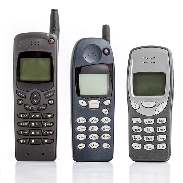
GNSS has had a major impact on many different industries and market segments, but I believe that the incorporation of GNSS into cell phones has impacted more people around the world than any other. It’s almost hard to remember back in the last millennium when the idea of putting a GPS receiver into a cell phone was first contemplated. Back then, we were just starting the transformation from 1G phones (analog) to 2G phones (digital), and the whole idea of 911 for mobile phones was a huge hurdle facing the entire industry. Three small startups (SiRF, SnapTrack and Global Locate) were all founded with the seemingly impossible dream of putting GPS into every cell phone to provide location information for E911 and other commercial applications. Back in those days, we were trying to convince operators and the FCC that GPS could provide location accuracy better than the 150-meters 67% of the time that the cellular industry was leaning toward with other technologies.
Can you hear me now? A sampling of early cell phones. (Photo: yktr/iStock/Getty Images Plus/Getty Images)
Fortunately for everyone, we were able to convince the industry that GNSS was an answer that should be considered. Today, we see billions of phones around the world with embedded GNSS. Those early phones from Motorola, Nokia, Ericsson and RIM (Blackberry) were truly marvels of engineering development to tightly couple GPS and cellular. Interestingly, none of those phone makers — nor any of those three pioneering companies — exist today, having been subsumed into larger entities due to their success in solving this incredibly complex problem. Those early GPS L1 C/A-only phones have added GLONASS, Galileo, QZSS and BDS, and we are now starting to see support for L5 showing up in smartphones. This has all led to improved availability and accuracy — now not only can we locate E911 calls to the correct civic address for emergency responders, but commercial applications rely on <10-meter accuracy for driving directions, ride sharing and social media applications. Every time I think there is nothing new to do, something always comes along. I’m excited to see what’s next.
Polaris Wireless, a provider of high-accuracy, software-based wireless location solutions, has signed a multi-year, multi-phase contract for delivery of a wireless location solution that complies with the Federal Communications Commission’s (FCC) most recent E911 wireless location accuracy mandate with The Alaska Wireless Network, a company wholly owned by GCI Communication Corp (GCI).
The first phase of the contract extension includes the Polaris Wireless Evolved Serving Mobile Location Center (E-SMLC) with hybrid location software for LTE networks that complies with FCC-mandated indoor location requirements. Subsequent phases include delivery of additional location technologies and hybrid algorithms as cellular networks and mobile devices continue to evolve and become more capable.
Polaris Wireless describes its hybrid location solution as inherently future proof to take advantage of improvements in cellular networks and mobile devices.
“We are excited to continue working with GCI in providing our software-based location solutions,” said Amir Sattar, vice president of global operations for Polaris Wireless. “Polaris takes great pride in GCI trusting us to provide GCI E9-1-1 callers with the highest level of location accuracy when and where they need it most.”
“We have enjoyed a long-term relationship with Polaris Wireless delivering wireless E9-1-1 location solutions for many years,” said Gene Strid, chief technology officer of GCI. “As the carriers must now locate E9-1-1 callers in challenging indoor environments, we are happy to leverage Polaris Wireless’s technological innovation and commitment in delivering high-accuracy, software-based location solutions.”
“Polaris Wireless E-SMLC product leverages all available and emerging technology to deliver the best location position accuracy we can for our subscribers’ emergency calls,” said John Myhre, vice president of wireless technology at GCI.
With more than 70 percent of calls to emergency services coming from mobile phones, getting necessary help — fast — to the caller can be challenging if they don’t know where they are or can’t communicate for any number or reasons related to the emergency. Current emergency solutions rely on cell-tower location, with a location radius of up to several kilometers, or assisted GPS, subject to errors indoors and unable to establish a floor level in tall buildings.
The U.S Federal Communications Commission estimates “improved location accuracy which results in reducing wireless E911 response time by one minute can result in saving over 10,000 lives annually.”
Google has created and rolled out in two European countries the Emergency Location Service in Android, with other regions to follow. The feature, when supported by the caller’s network, sends location from phone to emergency services when an emergency number is dialed. The feature is solely for the use of emergency service providers, and the caller’s precise location is never seen or handled by phone apps, integrating Wi-Fi, GPS, and cell towers to produce a more reliable emergency location indoors and outdoors.
Emergency Location Service is supported by more than 99 percent of existing Android devices (version 2.3 out and upwards) through Google Play services. The service activates when supported by the mobile network operator or emergency infrastructure provider.
The new geographical location system can identify the source of a mobile phone emergency call to typically within 0.003 square kilometers (less than half the size of a football field) instead of an average of around 12 square kilometers.
According to a British telecomm communiqué, “We see 84 percent being less than 50 m radius, with 16 percent up to 9 meters, 27 percent between 10 and 19 meters’ radius and 41 percent with 20–49 meter radius.”
When an emergency call is made with an enabled Android smartphone, the phone automatically activates its location service and sends its position by text message to the 999 service. This usually takes less than 20 seconds. This text message is not visible on the handset and is not charged for.
The text is automatically matched to the voice call and compared to the network’s cell-based information to ensure it is valid. The location is then made available to the appropriate emergency service, supplementing the cell-based information.
Because Google has tweaked its core Android Play Services software, it no longer needs each handset manufacturer to modify their handsets. Instead they can all be enabled as part of Google’s regular updates to its Android mobile operating system. This means the service will reach more handsets much more quickly.
In this screen capture of the what3words app, the pointer is on mouse’s head at the Magic Kingdom. That grid cell is named “perform.heckle.comfortable” and will not change.
Early this year, I wrote a short column about what3words, one of the exhibitors at the Esri Federal GIS Conference. Since then, I’ve run into a fair number of geospatial professionals who hadn’t heard about what3words. This month, I’m doing a deeper dive on it because I believe it will become part of our daily lives in just a few short years.
What is what3words?
what3words is a global location system using tessellated grid squares of the entire Earth. Each grid cell is roughly 3 meters by 3 meters, and each cell is uniquely named using a simple three-word combination such as “fork.lamp.book.” On initial consideration, one would think, “So what?” — until you understand the ramifications.
First, this has already been done. More than 57 trillion 3-meter squares have been named using only 40,000 words.
Second, the system is non-hierarchal, and the cells have no adjacent relationship, so minor errors are dramatically obvious.
Third, unlike GPS lat/long, the United States National Grid (USNG), the Military Grid Reference System (MGRS) or even street addresses, the three-word combinations are easy to remember and not easily misunderstood.
Fourth, the system is not just a 57-trillion record database; it’s a compact app (10 mb) that accurately generates the same unique name for each unique location with identifiers that are locked in concrete.
The what3words website has more information and a well-done video overview.
How did it come to be?
Surprisingly, what3words was developed not by a geospatial analyst, but by a musician who got tired of driving around trying to find the correct hotel loading dock or concert venue entrance using an address or verbal directions. Even GPS coordinates didn’t help, since it was easy to miskey numbers or misunderstand voice-relayed numbers. As a result, he and his team built an app that is easy to use, memorable and not error prone.
Early radio analogy
The system is so easy to understand that non-technical users can quickly adopt it. I believe that it will greatly speed communications, minimize mistakes, and reduce wasted time and mileage. To me, a good analogy is the World War I development of the phonetic alphabet.
In the early days of radio, voice communications were difficult and error-prone because of static, noise and garbled transmissions. To prevent mistakes, the military adopted a fixed list of words to help with aural identification of individual letters. The words were used for transmission of critical information such as map coordinates or to spell out words. (Alpha, Bravo, Charlie, Delta, etc.) A similar mind/ear relationship occurs with what3words. Here is a well-written technical appraisal and amplification by Prof. Robert Barr.
Possible uses
Military
The implications for the military could be significant. When I served on a destroyer, one of my duties was Gunnery Liaison Officer, providing naval gunfire support for troops in battle locations. The 5-inch gunfire was called in by concealed spotters in the battle space. The coordination and conversion between the spotter location, the spotter’s point of view, and our offshore position and line of fire required significant calculations and diligence, because friendly fire was always a concern. Current developments in GPS and laser technology have helped significantly, but friendly fire mistakes from guns, missiles and bombing are still a constant concern. The use of what3words could be a simple and quick way to double check and prevent targeting friendly locations.
Another issue that was a problem for some military bases was addressing, or E911. Some bases had buildings identified by numbers corresponding to the sequence of construction rather than street addresses, so building 245 might be next to building 1842 and next to building 38 (I’m not sure if this is still an issue). With what3words, help could be directed to exact building entrances or to exact locations in remote parts of a base.
Disaster response would also benefit. In many disasters such as tornados or hurricanes, street signs and building were obliterated. What3words would provide “addressing” for relief supply drops and other needs.
The location of the helo deck on the battleship Wisconsin in Norfolk, Virginia, is identified as “chew.sketch.hardly”.
First Responders
Whether it be an air crash needing remote mountain rescue, a farm accident in a rural area, a capsized boat at sea, or a heart-attack victim in a shopping mall or home, response could be significantly faster with less chance for error. Even in urban areas, there are frequent stories of delayed medical aid because E911 street databases were not correct or updated with new construction. what3words provides complete location coverage and would serve as an easy and effective double check for street addresses.
Government and NGO activity
Some of you may be familiar with U.S. Census Bureau TIGER files and LUCA (Local Update of Census Addresses). I still can’t wrap my head around why census workers have to keep posted house numbers and street names confidential. Perhaps using what3words could provide a simpler, unclassified way to direct census workers. Additionally, many actions that currently use GPS may be better served with 3m grid locations, such as agricultural or environmental data collection.
Business
Mundane activities such as materials delivery to unaddressed construction sites or package delivery to homes and businesses will be more efficient. (Rumor has it that a prominent package delivery service is testing what3words.) Utility companies could locate cut-off valves, meters and other assets within 7 feet of their actual location. Meeting friends, getting an Uber pick up, or even having a pizza delivered to a specific bleacher location at a Little League game would become easy.
Second and third world
There are complex issues regarding the World Bank and economic development. To qualify for major economic development loans, countries have to demonstrate that they have viable property ownership and taxation system in place so loans can ultimately be repaid. We take our tax parcel system for granted, but may third-world countries don’t even have consistent and comprehensive street names and addresses. what3words can provide “addresses,” which could lead to more comprehensive parcel identification.
On an even more basic level, the majority of citizens in the world don’t have an address for simple deliveries. When I was in a rural part of Haiti, just getting some simple wood screws was an all-day trip and ordeal. I learned to really appreciate being able to take a quick run to Home Depot or get two-day deliveries at my front door from Amazon. Those “luxuries” don’t exist in many parts of the world, and their lack really cripples those trying to start or run a business. what3words gives everyone an “address.”
Try it
Don’t take my word for it; try it yourself. Download the app on your smartphone (I’m using an iPhone, so others may be slightly different). Launching the app will display a map with your location and its what3words name. Click the “eye” to view an ortho image rather than a vector map.
If the padlock is locked, unlock it and you can move the map to different locations showing different what3words names. If you are sent a what3words location, you can click on the magnifying glass and type in the three words. The app will prompt “Near Me” or “Anywhere.” If there is no match near you, it will show possible options that come close by looking at alternate spellings or words. If you click “Anywhere” it will search the entire world for a match.
Once it takes you to the location, you can use Maps or Google Maps to get directions.
Other points
what3words has been adopted by many geospatial firms, including Esri. Available online or offline, anywhere in the world, the what3words locator can be available to the GIS team or customers across the entire ArcGIS platform. Since what3words is grid-cell layer, it may be possible to do map algebra operations on the cells in Spatial Analyst. I’m not sure there would be a benefit to that other than not needing to transform the list of affected cells.
what3words is available in several languages. The words are not simple translations, but developed for each language. Although the what3words team carefully scrubbed the words used to avoid offensive terms, I hope what3words doesn’t have to deal with lawsuits from individuals unhappy with the three-word identifiers of their location.
Conclusion
I predict that within a few years, our business cards will also include a what3words address. Simply put, I believe that what3words may prove to be one of the most significant geospatial advancements since Jack Dangermond spatially linked points, lines and polygons to a relational database.
what3words is going to save time, money and, most important, it’s going to save lives.
P.S. If you read my March column reviewing Peter Zeihan’s book The Accidental Superpower, you may remember the importance Peter placed on 3D printing affecting the geo-politics of shipping manufactured goods from China. If you haven’t seen the new CLIP technology 3D printers, you need to view this TED video to see how far the technology has progressed.
With market share second only to Ericsson, TeleCommunication Systems Inc. (TCS) is investing in location-based services (LBS), particularly those used for indoor location.
One key investment was the July acquisition of Loctronix, a small Seattle-based provider of positioning systems for GNSS-challenged environments.
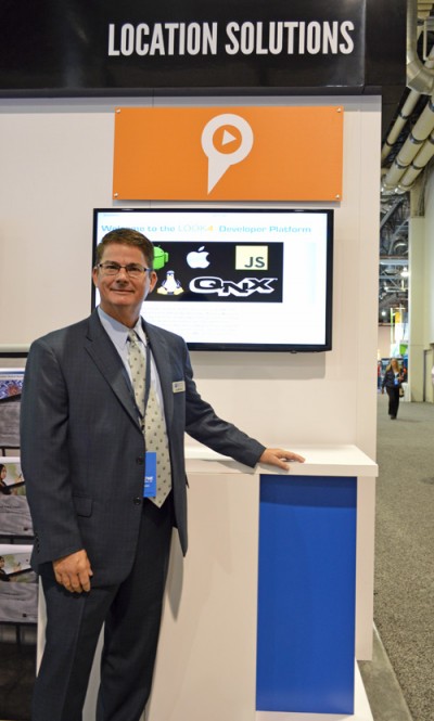
TCS senior vice president and commercial software group president Jay Whitehurst spoke exclusively to GPS World at CTIA Super Mobility 2015 in Las Vegas this week about the acquisition.
“We’ve been building out the (indoor location) technology, and we bought the assets of Loctronix and hired their CEO (Michael B. Mathews),” Whitehurst said. “They had a developed library and were at proof-of-concept almost ready to go to market and needed a vehicle to get it out there. We have 50 percent market share in E911, and in LBS we have 26 percent market share, relative to Ericsson’s 28 percent.”
Loctronix’s Mobile Explorer Platform is designed for mobile devices, and delivers high-accuracy positioning booth indoors and out.
The acquisition comes as TCS completes E911 interoperability testing with four public-safety equipment vendors, ahead of impending government regulation of E911 and with increasing public awareness about the need for emergency services that work with modern technology.
Beyond public safety and security, Whitehurst says there are “unlimited applications” for the company’s indoor location tools in the commercial sector.
From Mathews’ perspective, he made “the right choice” in selling his company. Mathews is now vice president of location technology at TCS.
“I found it was easy to be an evangelist, but scaling that into a commercial solution you could sell and make money on are two very different things. It’s easy to have vision, but you’ve got to have infrastructure and the scale of a company behind you to get it to happen,” he said, standing next to Whitehurst in the TCS booth. “We were able to fit into their infrastructure, and they’ve got a lot of tools we couldn’t wait to get our hands on.”
TCS plans to announce new geolocation tools based on the Loctronix assets in the fourth quarter. Without going into detail, Mathews described what’s coming as a “holistic solution” — then joked with Whitehurst that in his new role as a “tech guy” instead of CEO, “It’s not my problem.”
“The story we’re going to tell the next few months is pretty awesome,” Mathews said. “When we say location everywhere we mean location everywhere.”
Whitehurst presents VirtuMedix, a telemedicine platform using TCS’s LBS solutions
“In the healthcare market vertical, clinicians are licensed to practice in a state. So knowing when somebody is accessing a healthcare provider by a mobile device, we have to determine if they are in the state the clinician is licensed to practice. It’s an important usage of (location-based services).”
TeleCommunication Systems Inc. (TCS) announced at CTIA today that by year’s end the company will offer Network Functions Virtualization (NFV) for all of its technology solutions for location-based services (LBS) and messaging. Integrating NFV enables TCS customers, including global wireless operators and enterprises, to virtualize entire classes of network node functions into communication services that will cost-effectively run on common off-the-shelf, non-proprietary hardware platforms.
The new architecture is expected to enable customers to build specific and individualized networks that address their changing needs, and reduce time to market for new functionality and features. The solution can be deployed using a cloud-based, low-cost data center environment for both messaging and location solutions.
“By migrating all of our best-in-class solutions to NFV, we will be able to make our software available at any time and on non-proprietary platforms, reducing costs and complexity. This flexibility and agility will reduce customer costs, both CapEx and OpEx,” TCS Commercial Software Group President Jay Whitehurst said in a statement. “Virtualizing our location-based and messaging platforms is a critical expansion vector for TCS as we can now serve a larger set of customers in a more cost-effective manner.”
In a press release, TCS quoted a study by ABI Research saying it is the global leader in precise LBS infrastructure. TCS offers time-tested, end-to-end, LBS solutions that include applications, infrastructure, mapping, and content, processing more than 7 billion LBS transactions monthly.
TCS, based in Annapolis, Md., is a world leader in secure and highly reliable wireless communications. for E911, commercial LBS, cybersecurity, defense and more.
GeoComm has released an ebook focusing on assessing GIS data for an NG911 system (next-generation 911). In an NG911 system, GIS data development, accuracy, and maintenance are vital, and GeoComm approaches NG911 readiness in three steps: assess, improve and maintain.
The ebook, Key Steps for Assessing Mission Critical Data for 9-1-1, focuses on the assess step.
GeoComm approaches GIS data assessment by first identifying the current state of the reader’s GIS Data. NG911 GIS assessment can be completed by:
Educating stakeholders
Developing standards
Reviewing and analyzing GIS data
In addition to outlining the tasks for each of these three steps, the eBook includes an example of how the State of Iowa approached its NG911 GIS data assessment.
“Today is the day to begin preparing GIS data for its key role in a successful NG911 system. Whether you are tackling your GIS data assessment yourself, working with outside jurisdictions, or partner with a vendor; this eBook provides a valuable guide to accomplish your GIS data assessment,” GeoComm said in a statement.
The world of indoor location continues to evolve, with a number of variations on when and under what circumstances you might be able to wander around your local mall getting directions to your favorite ice-cream store on your iPhone. Some malls are mapped, some are not, some (most) have Wi-Fi hot-spots and Bluetooth beacons, some may be in areas where outdoor directional beacon are being tested and their signals penetrate indoors. But the thing they have in common is that most seem to lose GPS/GNSS signals once you get a few tens of meters away from the front entrance.
Some companies have managed to make indoor location in your mall work with a combination of GPS, plus all the RF signals that can be received, plus using inertial and/or magnetic sensors in your mobile phone, and sometimes also with detailed indoor map-matching — but no-one seems to do this in a simple, consistent, reproducible way for any store wanting to ensure you arrive at their door, or for a telecommunication industry wishing to standardize how it works for E911 and then field it everywhere.
So I’ve actually been looking for an indoor location outfit who might have found a consistent solution that can work from place to place — by that I mean from mall to mall, city to city, country to country, even continent to continent, and every time after first set-up — and I suspect that I may have now found one.
The team at iPosi in Denver is still working on their solution, but they have run some pretty convincing demonstrations in some very challenging locations, so they may have found an inside edge that could take them many places (sorry, about that pun).
While iPosi’s headquarters are is in Denver, the company also has labs in Boulder and offices in Dallas. It hasn’t been around too long — since 2011 — but it has been busy filing patents for the key technologies that drive their location technology. Of 40 total patents in the pipeline, five have been granted or allowed, 15 are pending, and 20 more are in development. With only six employees, iPosi is a small outfit, but it also gets design assistance from a European design center for other GNSS signal designs.
One of the key GNSS elements the iPosi team has going for them is an in-house developed GPS receiver with a sensitivity of -175 dBm. If you could get any sort of a signal deep inside a building, it’s possible that they might be able to receive it. But, for sure, anything you would receive deep inside would be just multipath – right? There are other pieces to this story however.
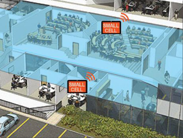
The iPosi system design is based on mobile phone “small-cell” installations. The world now has around 100 million multi-floor buildings with an average of eight floors each, and most buildings present some level of attenuation for external mobile phone cell-tower signals — never mind GPS signals. Most of us should be familiar with having to leave meetings to get “bars.” holding the phone up against a window, walking around to catch reflected indoor signals, and eventually having to leave the building and be with a group of other people who are doing the same thing – looking for a clear cell-phone signal to make a call. In the Northern U.S. and Canada in the winter, this can even be hazardous to your health!
So small cells behave as basically indoor “repeaters” of mobile phone signals. iPosi believes that an average of four of these repeaters are needed to broadcast sufficient signal on each average building floor. So iPosi embeds each small cell with one of its high-sensitivity receivers. Once positioned indoors, and over time, the receivers self-locate inside the building. Currently, installation of small cells can be somewhat cumbersome and time consuming, but non-GPS small cells can be located during installation using traditional indoor surveying techniques — such as laser-based measurements. Either that, or no measurements are made at all, and no device location information is associated with a device.
Small-cell setup.
With each small cell equipped with a high-sensitivity receiver — with especially clever algorithms to differentiate and interpret multipath over time — each device goes to work transmitting repeater mobile-phone signals and eventually self-locates. Contained within these signals are each small-cell location, plus a timing message that allows any standards-compliant handset to calculate range to each transmitter and to perform an OTDOA (Observed Time Difference Of Arrival) position fix.
If the small-cell location at install is also fed into the GIS database for the building and, more importantly, for the local area, the E911 “dispatchable address” for that building has GPS-level accuracy. And first responders will also have numerous other small-cell location aids within the building.
Another detail is that the iPosi receiver uses A-GNSS (including ephemeris) data, so it only needs small snapshots of signal to deduce position. This means very low power consumption for positioning at the small cell, which is good because small cells are mostly battery powered.
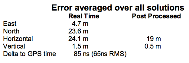
So, does it work? In FCC E911 demonstrations at the Omni Hotel in San Francisco, iPosi consistently located to within 50 meters horizontally and a few meters vertically.
Masonry, turn-of-20th-century construction
Approximately 15 floors, similar to surrounding
Test site: ninth floor hotel room
Horizontal error = 38 m, Vertical error = 9.5 m
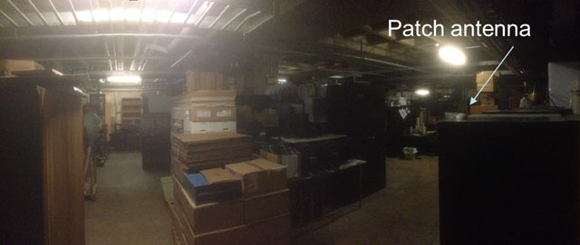
There were several other tests in representative converted apartments, a modern four-story steel and concrete building, and inside a university auditorium. But the one that really caught my attention was the test iPosi ran in the basement of an engineering center.
Engineering center, lower basement 3.5 m below grade.
That’s 3.5 meters below grade! The iPosi receiver measurement system was able to determine that some of the signals were actually received directly from a GPS satellite — unbelievable! That’s through concrete and stone down to 3.5 meters below grade with a simple patch antenna!
Most of your average mall locations are not as location-hazardous as this basement test. Its possible that finding your way to the closest indoor ice-cream store could soon be child’s play, which will be especially helpful for the kids with smartphones.
iPosi is working with some of the key equipment suppliers in the industry. It’s quite likely that some of its evaluation sites could soon evolve into operational indoor location facilities. And iPosi’s argument is that its indoor location solution is truly scalable or can be readily standardized — as the telecom companies apparently would love for all indoor location technology to be — so the iPosi solution can readily transition across borders and countries, and roll out could be greatly simplified.
Tony Murfin
Hard to say if this will be the winning indoor location solution, but in the end the market will decide if it really is a scalable, simple solution, and if it will succeed — right?
Sessions on indoor navigation and a keynote from Google at February’s International Navigation Conference (INC15), organised by the Royal Institute of Navigation, addressed the revised E911 positioning requirements in the United States, and flowed over into speculation about E112 emergency calling parameters in Europe’s near future.
According to the 2014 U.S. Federal Communications Commission report, 75 percent of 911 calls now come from mobile phones, more than half of those originate indoors, and around 1 percent of emergency calls contain no location information from the caller (due to distress, confusion, language issues, illness, and so on). The report estimates 10,000 deaths per year in the United States might have been avoided if a landline had been used instead, since location information for landlines can be provided confidently.
Discussion in the breaks of INC highlighted a misunderstanding amongst some parties that E911 mandates the use of GPS for position location determination. In fact,E911 does not mandate any specific technology; it specifies performance criteria in terms of accuracy that must be met. The recently revised performance criteria include indoor performance, and some of the technology discussed at the INC is able to meet these requirements without using GNSS at all.
This could be troublesome for Europe, which is looking at the imposition of Galileo as part of an A-GNSS technology push for the E112 application. The real problems, discussed during INC and in European consultation processes with safety of life services such as E112, are:
the accuracy of the position derived by the device and/or network, and
the timeliness of the delivery of that position to the Public Service Answering Point (PSAP).
The E911 directives address these points directly, and the infrastructure in the cellular networks is in place. Does simply implementing a Galileo capability into a European mobile device solve these problems?
In many outdoor cases, implementing Galileo can bring benefits, including signal diversity. And of course the E112 proposal is greater than just “adding Galileo.” It does address the second problem of timeliness of delivery and data transfer, but there are significant infrastructure upgrades required across Europe for the provision of this location data to the PSAPs.
What the E112 processes do not currently do is specify performance criteria for the position location accuracy. This means that the position estimate provided under E112 is likely to be a cell-ID fix, with an accuracy ranging from hundreds of meters to dozens of kilometers.
Galileo on Mobiles. Further discussion during the conference delved into the realms of the specifics of implementing A-GNSS, including Galileo, onto a mobile device. Conversations centered around if any future E911 or E112 positioning capability would be aligned around a single-chip solution as generally currently deployed on a device, or if some of the functions will be moved up the stack into the operating system (OS) of the device, into software.
Most opinions were against this latter concept, and a panel at the ION GNSS+ last year in Florida concluded the same thing. However, questions were asked about some ideas relating to identifying the emergency number at the time of dialing and then starting the position location determination functions in readiness for the need to provide the device location. This addresses the first bullet point earlier, the accuracy of the position derived by the device and/or network. If this is carried out in the OS or software layers, vulnerability of the system will be increased overall as the OS of a mobile device is a target for the cyber criminal community.
A robust software-based solution is, however, being rolled out in the United Kingdom in the form of eSMS, bringing mobile operators, government and handset vendors together to provide location data via SMS to the PSAP. The advantage of this approach is that no new standards or major infrastructure changes are required, and the time to implement is small.
Further discussions established that future chipsets are likely to use whatever GNSS signals are available, regardless of whether they are GPS, Galileo, GLONASS, Beidou and so on. This, coupled with new signal processing techniques (single-frequency observable for example), increasing sensor clustering on devices, and user demand for services, may make the use of a specific GNSS system above others somewhat redundant. Certainly picking up on a point made by Chandu Thota from Google, GNSS is “not relevant” for their indoor positioning solutions, and technologies they are working on, in both hardware and mapping improvements, are looking at meeting indoor accuracy requirements down to a target requirement of 1 meter, without GNSS.
Taking these points into account, questions were asked from the floor of the conference about the legal position of the EC mandating Galileo as a positioning method as well as the willingness of the global mobile chipset and device industry to be told what to do. Perhaps specifying strong performance criteria, as in the United States, is the way forward to “reboot” the European E112 system. No one disputes that a properly functioning E112 is a life saver and a good thing to do; however, the points discussed here detail some of the concerns expressed during and after hours at INC15.
In February 2015, the Royal Institute of Navigation hosted the International Navigation Conference in Manchester, UK. Keynotes at this well-attended conference included Harold Martin, director of the GPS Coordination Office; Gian Gherardo Calini, the head of market development at the European GNSS Agency; Todd Humphreys from the University of Texas; Chandu Thota from Google; and others. The conference covered multiple technology tracks including indoor navigation, autonomy, quantum technology and the resilience of GNSS systems.
Andy Proctor is lead technologist for satellite navigation at InnovateUK, the UK’s innovation agency. He acknowledges Ramsey Faragher, Cambridge University, for help in the preparation of this article.
The FCC will soon make a ruling on indoor location rules for 911 calls. If you worked in the location industry in the late 1990s, you may remember when the FCC ruled that wireless carriers would have to automatically locate a mobile phone that dialed 911 from the outdoors. From a seat on the E9-1-1 Institute’s board, a non-profit organization that supported Congress on 911 public safety issues, I watched the wireless carriers fight meaningful 911 location accuracy standards and monitoring.
With the large number of calls to 911 from the indoors today, the FCC is about to require carriers to automatically provide emergency dispatchers with indoor location information on calls. In the short term, the FCC is proposing indoor location that would provide sufficient information to identify a building, with more granular accuracy in the long term at the room or office suite level. In addition to horizontal locations, the FCC proposes adding vertical location, a critical metric for multi-storied buildings.
The comment period for the FCC’s proposal just ended and it is now up to the agency to act. During the comment period, carriers, public safety entities and vendors fought over accuracy rules and monitoring. NENA and APCO, leading public safety organizations, negotiated a consensus agreement on indoor location rules that many other prominent public safety agencies have decried as objectionable. It is surprising that NENA and APCO would sign on to such a watered-down version of the FCC proposal.
On a better note, indoor location for commercial applications is an industry bright spot. Hyper-location is king and is moving beyond retail to enterprise, personal asset tracking (please find my keys) and the connected home. “Over the past 12 months there has been a considerable change in deployments as companies have moved from a handful of deployments to getting into the hundreds and thousands of stores,” said Patrick Connolly of ABI Research.
In 2015, Connolly also expects to see camera analytics companies like Shoppertrak, Irisys and Brickstream have an increasing presence as they expand their offerings into BLE, Wi-Fi and in-store analytics. LED lights for location positioning within retail outlets and large public venues are on Connolly’s list for market growth in the coming year. The lights enable communication with the cameras on customers’ smartphones to determine their locations. Retailers can send information, redemptions, maps and services to customers via their mobile device at precise locations within the store.
I’d like to close the year with a “departure.” In Los Angeles, a proposed cemetery on the tony bluffs of Malibu would forego headstones, raised or flat, and depend on the grieved using GPS to find the burial spots of loved ones. A small disc on the plot would verify the coordinates. GPS as we didn’t imagine it.