MEDUSA sponsored a Think Tank May 19 in Tunis focused on EGNOS in Intelligent Transport Systems (ITS).
Delegates from 10 countries met in Tunis May 19 for an “All-day-long Think Tank” organized by MEDUSA. The sixty participants represented Algeria, Belgium, Czech Republic, Egypt, Jordan, France, Italy, Morocco, Tunisia and Slovak Republic.
Focused on the Intelligent Transport Systems (ITS) market, the event addressed the advantages of satellite navigation, and particularly of EGNOS and Galileo. ITS concerns the integration of information and communication technologies to create new applications and services for transport and mobility. ITS applies to all transport modes and is oriented to both passenger and freight transport. Satellite navigation plays an important role in ITS.
The MEDUSA Think Tank opened with a keynote speech by Ammar Habib of the Ministry of Transport of Tunisia, who reaffirmed the country’s interest in the development of ITS and in the cooperation with Europe in relation to the exploitation of the services offered by the European GNSS in the various transport domains.
The Euromed and European panelists gave a wide overview of existing and emerging applications in their countries, such as tracking and tracing of dangerous goods transportation, tracking special regulated fleets, emergency call, road tolling, urban traffic management, control of service fleets, and freight transit monitoring. They presented the existing technologies and value-added services that can be delivered through EGNOS today, and services that will become more robust thanks to Galileo in the future. It was recognized that the European GNSS, EGNOS and Galileo, can provide benefits to more than European countries and that, though primarily conceived for the aviation needs, EGNOS has interesting perspectives of utilization in ITS, and particularly in those applications requiring accurate and reliable positioning.
The participants from different sectors (policy makers, users, technology and commercial players, experts) shared their experiences and lessons learned. They also had the opportunity for networking, establishing relationships, and strengthening cooperation on GNSS and ITS.
Organized in combination with the Elgazala Innovation Days 2015, an international exhibition on information and communication technologies, the Think Tank is one of the technical assistance actions undertaken by MEDUSA and in the frame of the program of GEMCO (Galileo EuroMed Cooperation Office), the regional cooperation structure in Tunis set up and operated by MEDUSA.
About MEDUSA — MEDiterranean follow-Up for EGNOS Adoption
Coordinated by Telespazio, the MEDUSA project belongs to the Euromed GNSS program, part of the Euromed Transport framework. MEDUSA aids the Euromed countries in the operational introduction and the exploitation of the European GNSS (EGNOS/Galileo) in various applications, mainly in the transport sectors. MEDUSA runs a program of technical assistance actions, aimed at capacity building, development of enablers and regional cooperation on EGNOS/Galileo.
The twin-engine, wide-body Airbus A350 XWB, seen here at Spain’s Adolfo Suárez Madrid-Barajas airport, comes with EGNOS capability.
News by the European Space Agency
The EGNOS system, developed by the European Space Agency (ESA) for sharpening the accuracy of satnav across Europe, has been adopted by a growing number of airports to enable satellite-guided landing approaches. The new Airbus A350 airliner, currently entering service, comes fitted with it as standard.
“For the first time on the A350 we have a new system called the Satellite Landing System,” explained Jean-Francois Bousquie, an Airbus flight-test engineer focused on avionics. “This allows pilots to perform precision landing approaches guided by EGNOS or its U.S. equivalent, WAAS, offering vertical guidance down to a minimum of 60 meters before the pilot sights the ground to make the go/no-go decision on the final landing descent.”
The A350’s Satellite Landing System allows pilots to perform precision-landing approaches guided by EGNOS or its U.S. equivalent, WAAS. The capability offers vertical landing guidance down to a minimum of 60 miles before the pilot sights the ground to make the go/no-go decision on the final landing descent.
The European Geostationary Navigation Overlay System, or EGNOS, can provide horizontal and vertical guidance to anywhere in Europe, without the need for any additional airport-hosted infrastructure. By using three geostationary satellites and a 40-strong network of ground stations, EGNOS improves the accuracy of GPS signals over European territory, while also providing continuous updates on their integrity.
The result is that the EGNOS-augmented signals are guaranteed to meet the extremely high performance standards set out by the International Civil Aviation Organisation standard, adapted for Europe by Eurocontrol, the European Organisation for the Safety of Air Navigation. The signals from space can therefore be relied on routinely for the safety-critical task of vertically guiding aircraft during landing approaches.
A total of 131 airports in Europe offer some 225 EGNOS-based approach procedures. By 2020, 582 landing procedures are expected across 20 European countries. The largest international airports use Instrument Landing System (ILS) infrastructure, with radio beams offering a truly precision landing capability, including the ability to autoland when visibility is at its worst.
But ILS is expensive to install and maintain, so smaller regional airports often forego it. The same is true of many new or expanding airports. Even with larger airports, in many cases only their busiest runways are equipped with ILS. So EGNOS offers a cost-effective way of safely increasing use of remaining runways, boosting the flexibility of any given airport.
“By reducing the value of the minima — the lowest safely guided altitude — for non-ILS runways, EGNOS increases the efficiency and safety of aircraft landings,” added Bousquie. “The take-up of EGNOS by European airports remains relatively low for now, but this should change over time. And with the A350, we are really designing for the long term — each aircraft will have a working life of 25 to 30 years.”
“Every qualified commercial airline pilot has been trained on ILS, to follow its radio beam,” Bousquie said. “So the Satellite Landing System works by having them follow the same type of cues as much as possible on a ILS ‘look-alike’ basis, employing all available navigation data including EGNOS.”
A pair of onboard Multi Mode Receivers manage the A350’s radio sensors, compute the deviations and ensure interface with display and guidance systems.
First and foremost, let’s give a big hand to Adam and Anastasia, the two Galileo FOC satellites that were successfully launched on March 27. Following the not-so-successful Galileo launch in August, it was imperative that this go smoothly.
Although the Double-A launch occurred after the conclusion of this year’s Munich Satellite Navigation Summit, anticipation of the event set the context for the entire convocation. The summit is a fixture on the European and global GNSS calendar. It is always intense, often spectacular and sometimes leaves one with contradictory feelings. This year it took place March 24-26 and sought to determine the future of PNT, encouraging delegates to look into the crystal ball and predict developments.
If we go by the number of times these words were repeated during the three days of the summit, the future will hinge around compatibility and interoperability. The multi-constellation GNSS is already here. The elephant in the room remains, as always, interference, but here integration of alternative sensors and signals should hold the key to continuous and possibly resilient operations.
As usual the summit kicked off with a high-level plenary in the imposing Allerheiligen-Hofkirche (Court Church of All Saints) in the Residenz München, the Bavarian royal palace. The welcoming speeches and presentations were interspersed with some pleasant jazz, and the atmosphere was relaxed.
Into the Crystal Ball
Matthias Petschke, director of EU Satellite Navigation Programmes at the European Commission, admitted that 2014 had been difficult, but he was looking forward to 2015. Clearly the deployment of the Galileo infrastructure — especially the space segment — was critical, and the March 27 launch was very much on his mind. However, he expressed confidence that the launch would be fine and that satellite production was, and would remain, on schedule. In the long view, he stated: “We will make it for 2020,” signifying full operational capability (FOC).
He also talked about stimulating global markets to foster uptake of Galileo and EGNOS, and this was discussed by Carlo des Dorides, executive director of the European GNSS Agency (GSA). The ground infrastructure is very much in place and preparing for the Galileo exploitation phase. A significant milestone in that process would be finding the right partner to lead Galileo operations for the next ten years. A tender was now in process to find that organization or consortium. Des Dorides described the process as a competitive dialogue with the emphasis on finding a partner who can inspire new ideas and provide innovative solutions. The contract is big, worth around 1 billion euros.
Carlo des Dorides, Executive Director of the European GNSS Agency (GSA), discusses the 1 billion euro tender, now in process to find the organization or consortium to lead Galileo operations for the next ten years. Photo: GSA
He also emphasized the successes for EGNOS in the year. Almost 180 airports now benefit from EGNOS-enabled approaches and more than 70 percent of “GNSS-enabled” farmers in EU use the EU’s SBAS.
Johann-Dietrich Wörner, chairman of the German Aerospace Centre (DLR) — and the nominated next Director-General of ESA – highlighted the growing dependence of critical services on GNSS. In this context multiple systems were not a question of competition; it was all about redundancy and safety. Multi-GNSS improves availability, accuracy and reliability.
The view from the United States was given by Harold “Stormy” Martin, Director, National Coordination Office for Space-Based Positioning, Navigation, and Timing in Washington, D.C. The GPS fleet was now 30 strong in orbit including four successful launches in 2014 and he stated the 2014 averaged user range error to be 70 cms — the best ever — and improving year on year.
One major upcoming trend is a realization that there’s a need to establish a U.S.-wide backup coverage for GPS outage due to natural or man-made interference. The U.S. is currently assessing alternatives with a decision likely in summer 2015.
There was a particularly warm welcome from the audience for Michael Khailov, deputy head of Roscosmos and co-ordinator for GLONASS. Last year the Russians were conspicuous by their absence at the Munich Summit, but for 2015, despite the intervening local difficulty in Ukraine, they were back in force. Khailov claimed that the sustainable development of the world depends on GNSS. On more esoteric ground he stated that GLONASS had maintained stable operations in 2014 and three more satellites had bene launched. Further launches would depend on operational circumstances. The user domains for GLONASS were continuously expanding. Continuing the summit text he said that it was better [working] together than separately — in fact separately often doesn’t work at all and therefore we must continue to promote interoperability and the Munich Satellite Summit is a good forum for this.
Jianyun Chen of the China Satellite Navigation bureau also took up the theme of all GNSS together. Sixteen Beidou (pronounced — for the avoidance of doubt — as ‘bay-doe’) had been launched since 2007 and the Chinese had been in discussion with Russia to ensure full interoperability with GLONASS. This process will be repeated with GPS and Galileo.
GNSS Updates
One of the idiosyncrasies of the Munich Summit is its very discreet signage. If you don’t know where it is — and specifically the correct side door that brings you up two floors to the main Max Joseph Saal venue — it is highly likely you’ll miss it! But once you are in it is two full-on days of updates on systems and discussions on a vast range of topics that impinge on the development and implementation of GNSS around the world.
Discreet signage. Photo: GSA
The first two session of the summit proper gave updates on the GNSS systems in operation and under development as well as the regional and augmentation systems. Much of the material was slightly more detailed versions of presentations at the plenary but a few news snippet emerged.
“Stormy” Martin said that a modified battery charge control had been implemented that would extend operational life for some of the fleet by one or two years. He also reiterated the improving accuracy performance of GPS which was now much better that its published standards. He predicted that the first GPS III would be available for launch in 2016 and said that GPS was improving every day.
Eric Chatre from the European Commission reiterated that Galileo was still expecting to start early services in 2016 with full operational capability in 2020. He expected 18 satellites to be launched by 2018. The new Ariane 5 launcher will enable the launch of four satellites at one time and the first launch with this system would be in 2016. In terms of the ground segment only one station in the Pacific was yet to be established.
Sergey Karutin of Roscosmos talked about a four-fold accuracy improvement for GLONASS with the use of new clocks and the introduction of new CDMA signals that will improve accuracy and access. According to Dongfeng Yu of the China Satellite Navigation Office the BeiDou constellation is moving from “regional to global, active to passive” and is aiming for global coverage by 2020.
U.S. SBAS developments were covered by Deborah Lawrence of the Federal Aviation Administration (FAA). The Wide Area Augmentation System (WAAS) now has 100 percent coverage for LPV200 in CONUS. More than 41,000 runway ends are now included, and she predicted full completion in 2016.
Jean-Marc Pieplu of the GSA talked about EGNOS status. The next system release (2.4.1) should be published in Q3 2015 and will include a significant input on ionospheric corrections. Further service evolution includes a plan to declare LPV 200 in Q4 this year and EGNOS coverage will be extended to 72 deg North and ensure full coverage of the 28 EU member states.
The Russian Augmentation system SDCM performs at 0.8 metre accuracy according to Grigory Stupak of JSC / Russian Space Systems. He noted new validated SDCM ground stations had been established in Antarctica and Brazil and stated that global exploitation was a key objective for SDCM as its satellite coverage was very wide. GLONASS and GPS together could ensure complete coverage. He also indicated that work was in hand for SDCM SBAS service certification for LPV 200 and he called for providers of all WAAS to work closely together.
2020 Vision
After lunch we were offered the chance to hear some expert views on the future of GNSS and PNT with Prof Vidal Ashkenazi of Nottingham Scientific Limited asking for their vision of GNSS in 2020. By that year there should be 100-120 GNSS satellites in orbit, multi-constellation receivers would be the norm, but what would be the new applications and what were the challenges?
Jamming and spoofing would still be issues. Pierre Bouniol of Thales thought that in civil aircraft receivers would probably incorporate jamming indicators by 2020 to inform users when signals may be compromised. For Stuart Riley of Trimble the key was integration of other sensor signals to bridge any GNSS signal outage. Gang Mao of Unicore Communications Inc. in China considered multiple frequencies to be a big help in reducing the threat of jamming. Nigel Davies of QinetiQ agreed saying there were a host of technical solutions but key for success would be solutions that use low power, are low cost and feature high usability. He also noted that safety certification of receivers for use in driverless vehicles would be required and this challenging application would need the provision of robust continuous navigation — and sub-metre accuracy.
The future market for GNSS was also discussed in a session that unveiled the GSA’s 4th Issue of its comprehensive GNSS Market Report. With almost four billion GNSS devices used worldwide and all regions experiencing growth, GNSS represents an unprecedented business opportunity. Over the past 15 months the GSA’s team of market monitoring experts has taken a close look at all aspects of the GNSS marketplace with analysis of both hardware and software market opportunities, technology trends and future developments.
Gian-Gherardo Calini, Head of Market Development at GSA, gives highlights of the comprehensive GNSS Global Market report. He will deliver this information in an April 16 webinar hosted by GPS World. Photo: GSA
The top-line results were presented by Gian-Gherardo Calini, Head of Market Development at GSA. GNSS is one of the few growing markets in the world showing 12.7 percent CAGR. It is a very attractive market with volumes and revenues driven by mass market segments: the dominant two being Location-based services and transport applications. This latest edition includes information a new market segment: Timing and Synchronisation. One area that is not included is security and government applications. Mr Calini indicated that this information has been collected by the GSA team but as it is essentially for users of the Public Restricted Service (PRS) it was not included in the open report.
Although the report is very much “Galileo flavored,” its findings are of great importance and value to whole GNSS community and will be the subject of a GPS World webinar with Mr Calini and myself on 16 April. You can register — free — for this informative global perspective now.
A panel discussion followed and covered a range of topics and applications from aviation to agriculture. Again the consensus was that chips would become multi-constellation and quickly. Philippe Prats of STMicroelectronic outlined automotive applications from insurance applications to advanced driver assistance systems (ADAS).
The role of government mandates in establishing markets was seen as positive. The e911 mandate in the states had provided the seed for GPS integration into smartphones. Similarly authentication was also seem as a significant future market driver.
Multi frequency was also showing on industry’s radar and in a couple of years will be a reality thought Philippe Prats with the main motivation being better accuracy. Frank van Diggelen of Broadcom highlighted the recent GPS World feature demonstrating cm accuracy on a smartphone.
Legal Issues
A dedicated session on legal issues was not the best attended part of the conference, which is a shame as it had some serious points to raise and highlighted a gap that is opening up between our technical abilities in GNSS and the legal basis for its use. The Munich Summit is to be commended for its commitment to providing a platform for these issues every year; they are often ignored elsewhere.
Oliver Heinrichs, a partner at BHO Legal in Cologne, emphasised the need to establish a firm regulatory framework and to ensure that any decisions did not cross World Trade Organisation (WTO) provisions and the General Agreement on Tariffs and Trade (GATT). In particular the idea of mandating a specific GNSS for applications such as emergency response systems in cars may well be incompatible with WTO rules.
Amedeo Arena of Universitá degli Studi di Napoli Federico II in Naples noted that all GNSS players were members of the WTO and considered that GNSS services and their trade was definitely “caught by the GATTs” so no favouritism for ‘home’ systems should be allowed.
Another area of controversy is automated vehicles. In discussion after the session I learnt that current international conventions governing the use of motorised vehicles require a human supervisory role at all times. There will need to be some fundamental legal groundwork done before the first driverless vehicles will be allowed out on the road for real.
These are legally complex issues and certainty will only come from test cases. Talking of complexity Aleksey Bolkunov of the Russian Federal Space Agency revealed that the legal, regulatory and standardisation measures governing GLONASS and GNSS in Russia consisted of more than 900 documents originating at various different levels of the state. This clearly gave great scope for “regulatory collisions” and he is involved in work to develop a single regulatory framework that should eliminate the remaining barriers to GNSS use in Russia.
Emerging Applications
Peter Grognard of Galileo Services chaired a final session of the day on emerging applications. Bruno Bougard of Septentrio saw dependable accuracy as key to emerging markets. He thought high precision driven by surveying was becoming more and more mainstream. For autonomous driving the challenge was to provide cost-effective, dependable accuracy at 10-30cm that was safe, reliable, and always available. This would require multi GNSS, multiple signals, highly integrated sensors and transparent and open augmentation.
For Neil Gerein of Novatel the mantra is “Accuracy, availability, assurance.” Users needed availability to their PNT solutions at all times. He also saw future applications integrating GNSS with inertial sensors and correction systems for high accuracy without the need for a base station.
or Neil Gerein of Novatel the mantra is “Accuracy, availability, assurance.” Photo: GSA
Lionel Garin of Qualcomm Inc talked about ADAS. Safety was paramount and he foresaw the need for rigorous design and certification procedures similar to that required for the aviation market. Fortunately the industry has lots of expertise here. Philip Mattos of u-blox UK argued that a volume market is in femtocell and small cell synchronisation in mobile networks where GNSS is the lowest cost solution.
Tom Stansell praised geometry as the most important and unique ingredient supplied by multi constellation GNSS. And the second most important ingredient was interoperability. He doubted users would care where their signals originated and devices would still be generically described as ‘GPS’ into the future. Application growth will be stimulated by the better geometry supplied by multi-GNSS constellations. When the E6 signal became available he predicted that 10cm accuracy would enable reliable lane keeping for ADAS.
And Galileo will supply E6 for free said Ignacio Fernandez Hernandez from the European Commission. Ignacio works on the Galileo Commercial Service design and outlined some significant differentiators of the European system including its broad signal for high accuracy and better multipath resilience, more stable clocks and improved ionospheric modelling compared to GPS.
Lionel Garin sounded a note of caution at the end of the session when he noted that multi constellation ability was good, but he was not sure what was actually gained beyond two, or perhaps three, constellations.
GNSS for Weather
The final day of the conference saw a few fragile heads courtesy of the previous evening’s Summit Space Night 2015 sponsored by Airbus Defence & Space, which took place at the Filmcasino am Hofgarten close to the conference venue. And the first session, chaired by Oliver Montenbruck from the DLR, certainly required a clear focus as we were taken through the use of GNSS in space geodesy, space navigation and reflectometry.
Roland Pail from the Technical University, Munich described results from the satellite gravity missions GRACE and GOCE that looked at mass transport processes on our dynamic Earth. A particularly sobering animation showed the extent of ice mass loss from Greenland over the past decade. But what is role of gnss here? The ability to give precise positioning of the satellites and the fact that the satellite orbits carry information on the gravity field.
Atmosphere sounding using GNSS radio occultation allows precise atmospheric profiles with global coverage in all-weathers. Jens Wickert of the Helmholtz Centre Potsdam said that since 2006 these high vertical resolution profiles had been making a significant impact on the world’s weather forecasting including improved hurricane forecasts. It was also a bias free technique for observing global temperature change. With a multi-GNSS future new missions could be planned as more signals would reduce noise. Combining GNSS and reflectometry could enable accurate tsunami detection from space. Similarly Prof Antonio Rius from Barcelona was using reflected GNSS signals to determine data on the surface of the sea such as surface roughness, extent of sea ice and early warning of a tsunami.
Stefan Sassen of Airbus Defence & Space described the LION GNSS navigation receiver for MEO and LEO platforms. The unit was qualified since 2014 and now 50 were on order. LION is highly flexible with multi-frequency, multi-constellation and multi-antennae configurations possible. It was accurate enough for autonomous orbit raising (a few kms) and or station keeping (to within 100cm).
Finally Manfred Sust of RUAG Space GmbH said that space borne gnss receivers were true enabling technologies for Earth Observation missions as precise orbit determination was key to capturing sharper images.
Alternatives
The second session of the day returned to the practical issues around possible alternative or complementary PNT (APNT) systems. As GNSS becomes ubiquitous many terrestrial PNT systems are being decommissioned (LORAN, VOR), but the potential vulnerability of GNSS signals to interference is highlighting the need for backup. The challenge being to balance functionality and cost in the search for “plan ‘B’ for GNSS” as chairman Michael Meurer from DLR described it.
The FAA’s Deborah Lawrence reiterated her plans for scoping and implementing a backup system to cope with a GPS outage in the US. The FAA is currently engaging with stakeholders to define what the minimum operational target for a GPS outage should be to set the basis for procurement activity. The timeline for a final investment decision was now December 2018.
For Europe Gerhard Berz of Eurocontrol thought there were many potential APNT in place and the topic was in the SESAR 2020 research programme. He thought existing DME could potentially do the job in Europe as it had good coverage, but the challenge is to get good geometry and coverage at low altitudes, in remoter areas and over water.
Prof Per Enge of Stanford University “put the moose on the table” and pointed to the 978 and 1030 ranging frequencies as an existing system that could be used for positioning. But how accurate was it? Airborne experiments had shown good agreement with GPS positioning with an accuracy of around 100m and in turns 300m, which was good enough in an emergency. Further tests using a UAV at spider infested Camp Rogers had demonstrated APNT in flight with 50m error. The UAV itself was specifically developed to navigate using APNT while looking for GNSS jammers.
Wouter Pelgrum of Ohio University discussed the relative merits of eLORAN, which has high power – and therefore difficult to jam – and beyond line of site accuracy of less than 10m, and alternatives such as collocation of pseudolites with mobile phone cell towers. This could also enable high accuracy indoors positioning applications. He believed that APNT will need to be context specific and there was no single solution.
Belabbas Boubeker of the DLR discussed modular APNT concepts while Nick Ward of the UK’s General Lighthouse Authorities indicated there was no coordinated policy on resilient PNT in the European maritime sector at present but his authority and others were exploring the possibility of using eLORAN as a commercial enterprise. Nine transmitters were operational in Europe and the service had been declared in 2014.
Michael Hoppe of Fachstelle der WSV für Verkehrstechniken said resilient PNT was a core element of e-navigation for waterways. A combination of techniques such as medium frequency RF, AIS and eLoran could give good accuracy in areas of highest traffic. First results of trials were encouraging.
Processing Power
The final session of the Summit to grab my full attention was chaired by Frank van Diggelen of Broadcom. He led a wide ranging debate on GNSS receiver architecture trends and more generally the future of chip design and fabrication: are we approaching the end of Moore’s law and if so — what next?
Recently “The balance of power has moved back onto the GNSS chip” to enable lower device power use. To highlight current developments Frank described a couple of Broadcom products: the Broadcom 4773 “location hub” that is at the heart of the Samsung Galaxy 6 “super smart phone” and the 4774 that can access signals from all four GNSS constellations and will be shipping in early 2016 on new smartphones.
In fact earlier this year the 4774 was used to make a first fix using signals from four different GNSS constellations (with signals from one each of GPS, GLONASS, Galileo and BEIDOU satellites) and a significant event in terms of our multi-constellation future.
Greg Turetzky of Intel talked about the benefits and challenges for GNSS in advanced silicon processes. He noted that Intel is now shipping 14nm technology and plans were in hand for the next two generations (10nm and 7nm). Moore’s law has been a great enabler for modern society. If automobiles had taken a similar development in the same timeframe we would all be driving cars with a maximum speed of some 300 000 km/hour that cost us around 4 cents to buy!
The big challenge for GNSS architecture was to take advantage of the smaller geometries while greatly reducing standby power. The integration of multiple radio sources to provide a single location solution was key giving ubiquitous location capability that will improve the experience of every mobile product.
Looking into his crystal ball, Peter Anderson of Integrated Navigation Systems in the UK saw that integrating signals from complimentary technologies and sensors would be important but would lead to a greater demand for digital processing. He predicted that multiband receivers would become standard in consumer devices. He also pointed out that the worst potential source of GNSS jamming for a smartphone was the phone itself! The move to dual frequency would be helpful here.
An overview of the Chinese XIHE system for seamless outdoor and indoor location was given by Dongkai Yang of Beihang University. This Beidou Innovative application provides a LBS system based on gnss and mobile communication networks to give a “fusion of communication and positioning for indoor positioning”. The system is being demonstrated in four areas in China in shopping malls. The target for positioning accuracy in the system is for less than 3 metres indoors and less than 1 metre outdoors.
Franz Kreupl of Munich Technical University gave a sobering view of “life after silicon” – essentially it looks like there isn’t one. He outlined the limits to silicon technology such as tunnelling current and predicted some further progress could be made in reducing interconnect sizes and via circuit design. But new candidate materials for semiconductor electronics from carbon nanotubes to widely hailed 2-D materials graphene and MoS2 all suffer major issues that seem to make them non-starters.
But do we need to keep on miniaturizing? Norbert Schuhmann of Fraunhofer IIS in Nuremberg thought that technology downscaling would have an end in terms of the physics, but especially in terms of reasonable cost. He thought 7nm and 2020 was the end point for the physics but that in fact 28nm should be seen as the actual last node in Moore’s law as from then scaling has no longer also been the path for cost reduction. He saw silicon on insulator technology and monolithic 3-D integration as possible paths forward, but the technology sweet spot — and well suited for GNSS — was 55nm and a format that was already extensively used in automotive applications.
SAFIR is part of the Africa-EU long-term strategic partnership to enhance safety in air transport. Its global objective is to build capacity within African ACP countries for the future deployment of GNSS/EGNOS in the region. The three-year project is funded by the European Union and financed from the 10th EDF Intra ACP envelope with 3.7 million euros, under an international consortium led by ASECNA (Agence pour la Sécurité de la Navigation Aérienne en Afrique et à Madagascar) with Egis, Pildo Labs and ESSP.
The ceremony took place in Dakar on March 3. Those attending included Matthias Petschke, EU Satellite Navigation Programmes director; Karolina Stasiak from the UE Delegation in Sénégal; and Amadou Ousmane Guittèye, director general of ASECNA.
“Satellite navigation can bring huge societal benefits, be it in transport, in agriculture or land management,” Petschke said in remarks at the launch ceremony. “Satellite-based augmentation systems in particular, like EGNOS, can bring enormous social and economic benefits. I attach, therefore, great importance to the setting up of the EGNOS Africa Joint Programme Office and am particularly pleased to see this team of African experts who have extensive experience and knowledge to support the development of an African satellite based augmentation system.”
In his speech, Guittèye said, “The first mission of the JPO is to ensure Africa has developed adequate competencies and then to coordinate the implementation of the development and of the deployment of GNSS/EGNOS services and applications in the continent. The EGNOS-Africa Joint Programme Office (JPO) is a pan-African entity that acts for the benefit of Africa and supports stakeholders in their GNSS/EGNOS strategy, developments and implementation.”
The ceremony also was attended by officials from the International Civil Aviation Organisation (ICAO), the African Civil Aviation Commission (AFCAC), the Agence Nationale de l’Aviation Civile et de la Météorologie (ANACIM) , the Aéroports du Sénégal (ADS) and local authorities.
The SAFIR project began on January 15, 2013. It covers the set-up, staffing and operations of an EGNOS-Africa Joint Programme Office, and sets up and supports a number of technical working sessions composed of regional stakeholders concerned with GNSS/EGNOS in sub-Saharan Africa.
ASECNA has 18 member states. With air navigation safety as its main mission, it cooperatively manages African airspace for the countries of Benin, Burkina Faso, Cameroun, Central African Republic, Comoros, Congo, Côte d’Ivoire, France, Gabon, Guinea Bissau, Equatorial Guinea , Madagascar, Mali, Mauritania, Niger, Senegal, Chad and Togo.
By Ugo Celestino, European Commission, Antonella Di Fazio, Telespazio SpA, Vicente José Giner Herrera, Ineco, Patrizio Vanni, ENAV SpA, and Francisco Javier Deblas, ESSP.
This article describes a live demonstration of an aviation application in Tunisia, to help the local aviation community in validating the use of the European Geostationary Navigation Overlay Service (EGNOS) to guide airplanes during landing operations. This activity constitutes the first complete experience of EGNOS Safety of Life (SoL) service for aviation approaches outside Europe. We present here the obtained results that are useful not only for Tunisia, but as a valuable case study for other countries outside Europe interested in using EGNOS in aviation.
EGNOS, operational since 2009, has a European regional coverage that could be quite easily extended to areas adjacent to European Union through the deployment of limited additional ground infrastructure elements, but sharing the same existing space segment and leveraging the other core ground infrastructure.
The European Commission has put in place a series of actions since 2006 to support the EGNOS service extension in neighbouring areas. The MEDiterranean follow-Up for EGNOS Adoption (MEDUSA) is an on-going European initiative related to EGNOS extension in the Euromed region, including North African and Middle East countries around the Mediterranean basin: Algeria, Egypt, Israel, Jordan, Lebanon, Libya, Morocco, Palestine, Syria, and Tunisia. MEDUSA runs a program of technical assistance action in these Euromed countries, in order to prepare them for an optimal adoption and exploitation of European GNSS services in their priority market segments.
The Mediterranean Extension of EGNOS
EGNOS is Europe’s first venture into satellite navigation and paves the way for Galileo, Europe’s independent global satellite navigation system currently under deployment.
EGNOS is a satellite-based augmentation system (SBAS), whose signal is compliant to the international SBAS interoperability standards: standards – MOPS (Minimum Operational Performance Standards) and ICAO SARPs (International Civil Aviation Organization Standard and Recommended Practices). In its current version (V2) it augments the open public service offered by the American Global Positioning System (GPS), by providing correction data that enables to improve GPS position accuracy, and provides integrity information about the GPS system (integrity information is fundamental for aeronautical applications like approaches). EGNOS is interoperable with the other equivalent regional systems. Today other SBASs are the U.S Wide Area Augmentation System (WAAS), the Japanese Multi-functional Satellite Augmentation System (MSAS), the Indian GPS Aided Geo Augmented Navigation (GAGAN) and the Russian System for Differential Correction and Monitoring (SDCM). The future version (V3) of EGNOS will augment Galileo signal as well.
Today EGNOS is operational, and available for use in aviation since 2011, giving opportunities for users to have more accurate and reliable positioning for enhancing existing applications, developing new applications and particularly the safety critical ones. Already more than 150 landing procedures are operational across Europe (some of them also in countries out of the European Union, such as Switzerland, Norway, Guernsey), with many others under development to reach 100 percent Approaches with Vertical Guidance (APV) coverage in the European instrumental runways as per ICAO recommendation.
EGNOS provides three services:
EGNOS Open Service (OS), launched in 2009, is delivered free of charge. It is open for use to anyone with an EGNOS-enabled receiver. This can be any receiver compatible with satellite-based augmentation systems. Being based on GPS, the EGNOS signal does not require major changes for receivers. Today, many mass market receivers available on the market are also EGNOS enabled. EGNOS OS is particularly suitable for mass market and some applications like surveying.
EGNOS Safety-of-life Service (SoL) is authorized for European civil aviation and operational since March 2011. EGNOS SoL delivers the integrity message providing the verification of the GPS system and timely warnings (within six seconds), when the system or its data should not be used for navigation. Since integrity relates to the trust that can be placed in the correctness of the location information supplied by GPS, thanks to this feature EGNOS is able to meet the demands of safety-critical applications in sectors such as aviation.
EGNOS Data Access Service (EDAS) launched in 2012, delivers a terrestrial commercial data service. It consists of a server that gets the data directly from EGNOS system and disseminates it via terrestrial networks in real time, within guaranteed maximum delay, security and performance. EDAS is particularly suitable for professional applications. It provides EGNOS raw data and corrections enabling software solutions that implement products and value added services built on them.
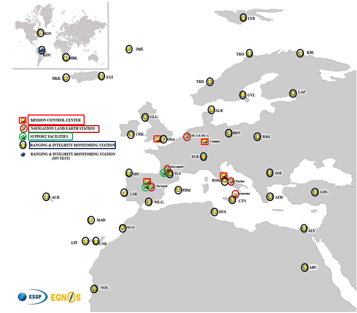
EGNOS infrastructure consists of three geostationary satellites over Europe and a network of ground stations (Ranging and Integrity Monitoring Station – RIMS) located to provide services whose coverage includes southern Europe, North Africa and some Middle East countries.
The EGNOS RIMS network supports a flexible network geometry that gradually adapts to service coverage requirements evolution. From the originally envisaged coverage over European Union’s countries, the EGNOS RIMS network is being expanded over Europe’s neighbouring areas, thus increasing the number of beneficiary countries. EGNOS SoL service is highly sought by several non-EU countries for the benefits it can bring to their civil aviation, in providing a solution to comply with ICAO requirements for Performance Based Navigation (PBN).
The present layout of the EGNOS RIMS network is presented in Figure 1.
Figure 1. EGNOS ground segment.
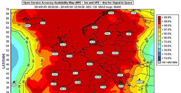
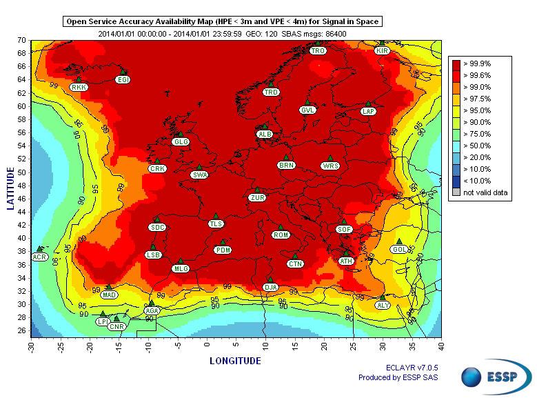
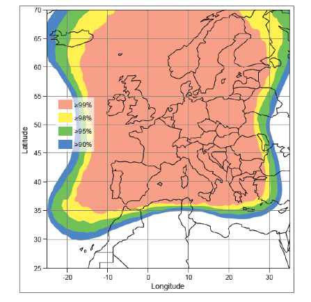
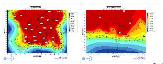
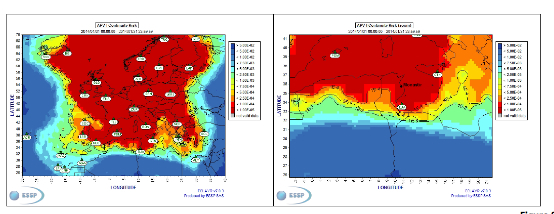
Figures 2 and 3 show respectively today’s coverage of EGNOS OS availability (source: European Satellite Services Provider, the service provider of EGNOS) and the APV-I availability performance commitment provided by EGNOS SoL (source: EGNOS Safety of Life Service Definition Document, EGN-SDD SoL, V2.0, European Commission, 2013), obtained relying on the above presented ground segment.
Figure 2. EGNOS OS Availability.
EGNOS OS Availability. The Figure 2 map is obtained by projecting the error at pseudorange level into the position domain. The computed error assumes that the GPS satellites used are those with an elevation angle above the local horizon (with a mask angle of 5º) and does not consider any possible factor depending on local characteristics that could produce different results (optimistic or pessimistic) with respect to the results computed using real receivers located in the considered areas. Moreover, it represents an estimation of EGNOS OS availability during a very limited period of time being an estimation, thus it does not imply any commitment or reference for the performances which can be obtained during different periods.
Figure 3. EGNOS APV-I Availability.
Other initiatives for a further extension in North Africa and Middle East are already being developed, under the umbrella of the Euromed GNSS programme. In parallel with the infrastructure deployment, the Euromed GNSS programme also includes actions to support the introduction and exploitation of EGNOS services. The first stage was completed in the frame of the Euromed GNSS I/MEdiTerranean Introduction of GNSS Services (METIS) project in the period 2006-2009, the second stage is presently running in the frame of the Euromed GNSS II/MEDUSA project. Further initiatives are being planned for 2015 and beyond.
EGNOS Use in Aviation
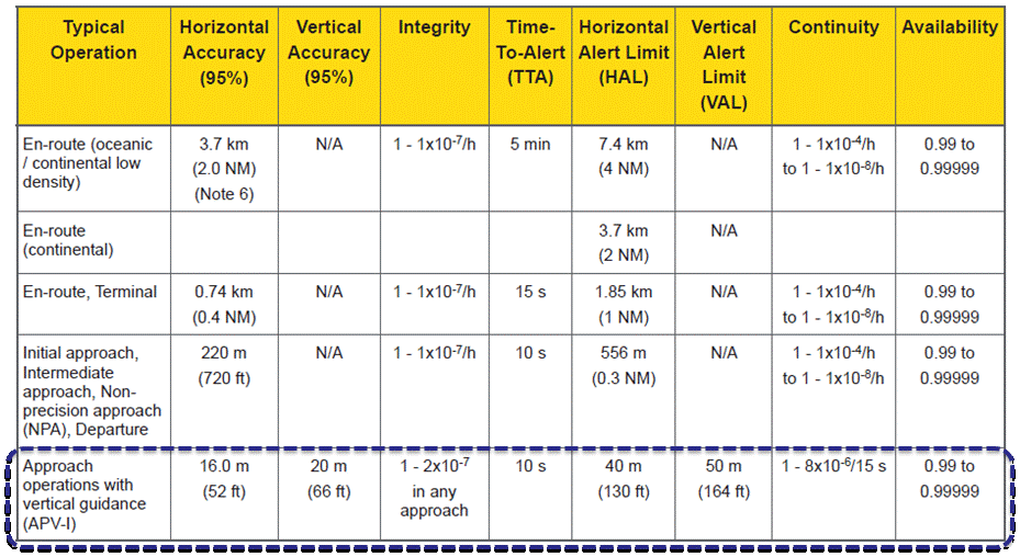
EGNOS was initially designed and developed to be used in aviation, similarly to the U.S. Federal Aviation Administration WAAS, to support different types of aviation applications and, in particular, to meet the performance requirements set by the International Civil Aviation Organization (Annex 10) for the implementation of APV-I, which enable the implementation of LPV final approaches, as reported in Table 1.
Table 1. ICAO Operational Requirements.
EGNOS is one of the GNSS elements recognised by ICAO (Annex 10) as a radionavigation aid. It is an important element of a global SBAS systems mosaic, that started with the American system WAAS in 2003, and that is gradually completed by other more recent SBAS: EGNOS itself, MSAS (Japan), GAGAN (India), SDCM (Russia), and some countries like Australia and South Korea that have launched feasibility studies to develop their own SBAS.
It is expected that, in a not too far future, most parts of the world will profit from SBAS services, following the current coverage extension plans and SBAS system evolutions. The final objective, as also shared at ICAO level, is that as many airdromes worldwide, as possible, can offer instrument approaches with vertical guidance, with an outstanding increase in global safety rates.
Additionally, the use of EGNOS allows taking full advantage of GNSS for all phases of flight, including final approach. Therefore, EGNOS means for aviation a fundamental and strategic tool to help meet ICAO’s recommendations, aimed at the adoption of a PBN oriented airspace use policy, for all countries. The 37th Assembly of ICAO (28 September – 8 October 2010) resolved that APV procedures should be implemented as either a primary or backup strategy for precision approaches at all instrument runway ends by 2016.
APV is a major safety initiative. ICAO recognises SBAS and Barometric Vertical Navigation (Baro-VNAV) as the two acceptable (and often complementary) means of implementing APV procedures, which are safer than NPA (Non Precision Approach).
GNSS based navigation enables RNAV (aRea NAVigation) with a higher cost effectiveness in comparison with the old conventional, sensor ground-based, navigation procedures. This is especially true for wide, even desert unequipped areas (or difficult to maintain) like those in North Africa and Middle East.
EGNOS benefits are maximized in final approach manoeuvres, providing GNSS lateral and vertical guidance, and enabling APV-I approaches.
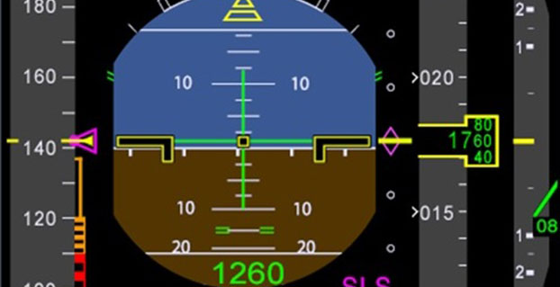
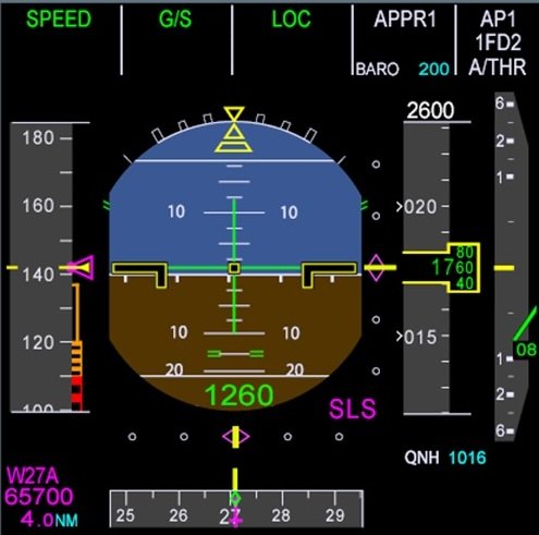
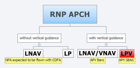
Final approach procedures based on GNSS are classified as RNP approaches (RNP APCH, as shown in the next figure), namely: Lateral Navigation (LNAV) with GPS lateral guidance and no vertical guidance; LP with GPS + SBAS (EGNOS) for lateral guidance (CAT-I localizer performance) and no vertical guidance; Lateral Navigation/Vertical Navigation (LNAV/VNAV) with GPS lateral guidance and Baro-Vertical Navigation (VNAV) vertical guidance (Baro-VNAV approach procedures can be flown with SBAS vertical guidance upon the approval of the Air Navigation Service Provider (ANSP)) and the LPV (Localizer Performance with Vertical Guidance) with GPS + EGNOS for both lateral and vertical guidance.
Figure 4. RNP approaches.
Those procedures not including vertical guidance are intended to be flown with the Constant Descent Final Approach (CDFA) technique (to avoid dangerous dive and drive practices), supported by most Flight Management Systems (FMS).
Regarding the operational LPV main figures, the European regulation (EU OPS -REGULATION (EC) No 859/2008 usually known as EU OPS) allows LPV operational minima (Decision Height – DH) down to 250 ft, expected to be possibly lowered down to 200 ft by 2015 (LPV-200), similarly to what is already permitted by the FAA, in the United Sates for WAAS based LPV approaches (a DH of 200 ft would make LPV approaches very competitive, when benchmarked against ILS CAT-I, precision approach, or even Ground Based Augmentation System (GBAS) CAT-I precision approach).
In the last few years, about 150 LPV procedures (status as of July 2014) have been published in European airports, and the number of procedures and countries introducing EGNOS is continuously increasing.
Euromed GNSS I/METIS and Euromed GNSS II/MEDUSA
In parallel with the development of the infrastructures necessary for extending EGNOS availability across the Euromed region, the European Commission has put in place initiatives to prepare and assist the Euromed countries for the optimal use and adoption of the relevant services.
These consist in two sequential projects, the first being Euromed GNSS I/METIS project and the second being Euromed GNSS II /MEDUSA.
Running from mid 2006 up to the end of 2009, METIS acted as a pioneer in the Euromed countries and built national/regional liaisons with decision-makers and key stakeholders, interested in sharing experience and absorbing know-how. The project assisted the 10 Euromed countries to identify their priorities in relation to the use of EGNOS services, to validate the relevant opportunities from the strategic/social and economic perspectives, and to elaborate a suitable strategy and a plan of actions for facilitating EGNOS adoption and exploitation.
MEDUSA Case Study in Tunisia: LPV Approaches in the Airport of Monastir Using EGNOS
As part of the technical assistance actions programme in the priority domains, MEDUSA implements demonstrations and validations of EGNOS services in concrete applications.
For EGNOS SoL, the technical assistance action consisted in the validation of GNSS approaches, including LPV approaches, designed and constructed in MEDUSA along with the relevant safety assessment and business case for the airport of Monastir in Tunisia (35°45’29’’ N 10°45’17’’ E). The selection of the airport was driven by a trade off between the EGNOS service availability with required APV-I performances and the specific needs of the Tunisian Air Navigation Service Provider – ANSP (OACA, Office de l’Aviation Civile et des Aéroports). According to OACA, Monastir is among the airports in Tunisia presenting favourable conditions, in terms of operational constraints and traffic, for concretely proving the added value of EGNOS for final approaches.
The airport has two runways, RWY 07 and RWY 25, the former is equipped with an ILS CAT-I, the latter only supports NPA approaches. The installation of an ILS in RWY 25 was discarded due to technical constraints. This infrastructure has proven to be insufficient to fully cover the airport needs, that suffers some Delays-Diversions-Cancellations (DDCs) as a result of local specific meteorological conditions, frequent fog banks entering from the sea in the early morning, combined with desert haze. These conditions make LPV ideal procedures, as backups to RWY 07, and enabling APV approaches to RWY 25. Finally, Monastir’s TWR ATC (Tower Air Traffic Control ) staff has been involved in OACA’s PBN development, for which they were ideal candidates to evaluate the benefits possibly achievable from the use of EGNOS.
This MEDUSA’s technical assistance action is the first complete experience for the use of EGNOS SoL service outside Europe. It was conceived as a realistic exercise of RNP APCH procedures implementation, following the guidelines provided by ICAO in the “EUR RNP APCH Guidance Material (EUR Doc 025)” and including all the activities required, from the scenario adequacy study to flight validation and the requirements analysis for the final publication in the AIP (Aeronautical Information Publication). OACA was directly involved in all activities, providing inputs/feedbacks and for training purposes.
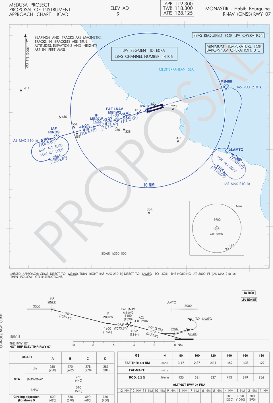
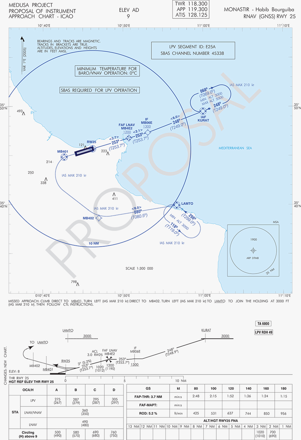
A set of three GNSS based approach procedures was produced for each RWY, following ICAO 8168 PANS OPS design principles. The next figures show the combined charts type elaborated, that include minima boxes for three RNP approaches (LNAV, LNAV/VNAV and LPV). The procedures construction preserves the current Monastir arrivals structure, following airspace management principles and facilitating the operational approval. As illustrated in the charts, in both cases for the three minima the calculated OCH (Obstacle Clearance Height) values improve with respect to the already existing conventional approaches, providing significant operational and safety benefits.
Figure 5. GNSS approaches for RWY 07.Figure 6. GNSS approaches for RWY 25.
An on-site GNSS performance monitoring campaign was performed by OACA, with the support of GEMCO’s staff, 3 months before the flight trials schedule, covering both EGNOS and GPS signal performances. Besides, an APV-I availability study for the area and specifically for Monastir airport during 1 month before the flight validation was purposely elaborated by the European EGNOS service provider (ESSP). Both analyses, confirmed suitable APV-I performance in terms of availability and continuity, making feasible the implementation of LPV approach procedures in line with ICAO prescriptions.
The next figures show the EGNOS APV-I availability and continuitymeasured on one day during the period of the flight validation (conducted from 30 January to 1 February 2014), in particular at Monastir airport for the considered time-lag:
APV-I availability was over 99%;
APV-I continuity presented a total value lower than 5×10⁻⁴/15s;
95th percentile of Horizontal APV-I accuracy was between 1.1 and 1.2 meters and the 95th percentile of Vertical APV-I Accuracy is around 1.4 meters, thus showing a very good accuracy level;
Horizontal and Vertical safety indexes were lower than 0.25, representing a very good integrity margin.
Additionally, the results of the on-site GNSS performance monitoring campaign showed quite stable performances with small fluctuations during the whole period of observation, and no problems or outages were observed.
(EGNOS APV-I Availability is defined as the percentage of epochs in a month in which the Protection Level are below Alert Limits for this APV-I service (HPL<40m and VPL<50m) over the total period (source: ESSP).
EGNOS APV-I Continuity Risk is defined as the result of dividing the total number of single continuity breaks using a time-sliding window of 15 seconds by the number of samples with valid and available PA navigation solution. A single continuity break occurs if the system is available at one epoch and becomes not available for the following 15 seconds (source: ESSP).)
Figure 7. APV-I availability on 31.01.2014.Figure 8. APV-I continuity on 31.01.2014.
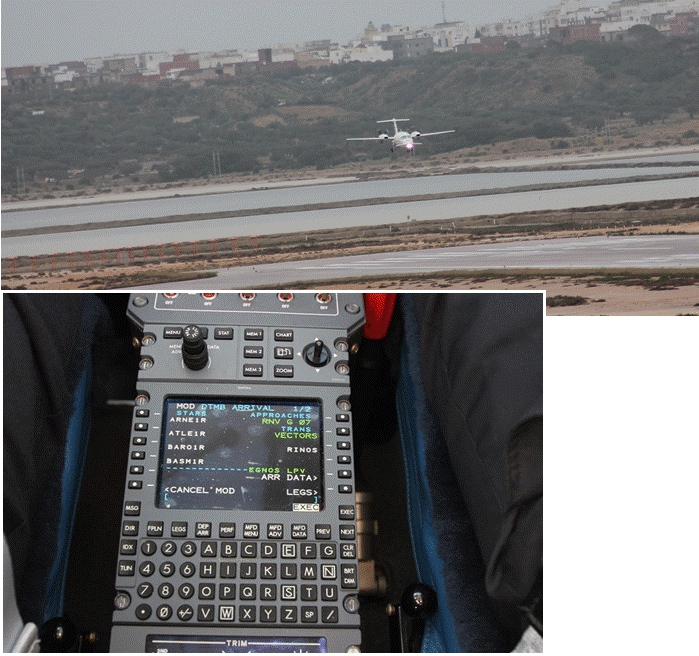
The flight validation campaign was carried out according to ICAO doc 9906 with a Piaggio P180 Avanti II (from ENAV flight inspection department) suitably equipped with UNIFIS 3000 system and a Rockwell Collins FMS 3000 with SBAS LPV approach capabilities.
Figure 9. Piaggio P180 Avanti II aircraft and the FMS messages during the flight validation.
The outcomes of this concrete experience have allowed the Tunisian authorities to identify the main elements for the publication of the validated procedures in their national AIP. They have also contributed to the analysis of the necessary process for the operational adoption of GNSS, including EGNOS, in aviation in countries beyond the EU boundaries.
The activities performed on performance assessment have been preparatory for discussions on GNSS monitoring and data recording on going at ICAO Navigation System Panel level, that would produce ICAO guidelines for States.
Therefore, this Tunisia’s “case study” represents a practical and realistic example that could be beneficial for the other non-EU countries in terms of best practice and lesson learnt. Moreover, methodology and guidelines have been derived to be possibly injected to other non-European countries interested to introduce EGNOS operations in aviation.
Lessons Learned and Outlook
Through its achievements, MEDUSA is opening the way for the introduction of EGNOS SoL service in North Africa and Middle-East region, and it is also defining a suitable path to be followed by other interested non-European countries. Overall, MEDUSA is continuing to confirm the ability to foster cooperation and involvement in EGNOS programme of the great majority of the Euromed countries. Further to Tunisia, other Euromed countries have already expressed their interest in relation to the EGNOS use in aviation, considering each country’s strategy and also in the light of a common shared regional perspective. Besides, the results obtained by MEDUSA are useful also for other regions interested to use EGNOS in aviation.
Additionally, MEDUSA is clearly showing that Euromed region, presently lacking the full support of SBAS technologies, represents an opportunity for EGNOS service extension, with many benefits for the countries of the region and for Europe.
On one hand, being SBAS an effective and efficient technology to enable the aviation community of the Euromed countries to comply with ICAO recommendations on PBN implementation by year 2016 across the region, the services coverage extension of existing SBAS systems (EGNOS in the case of the Euromed countries) can be one of the most efficient ways to move forward. In fact, the Euromed national ANSPs consider the readiness of EGNOS SoL service as one of the main drivers and factors when designing their PBN strategy. EGNOS, which is already operational since 2009 and available for use in aviation since 2011, can deliver added-value services to the Euromed region, just by leveraging the existing European infrastructure with only incremental, marginal and natural extension. The EGNOS coverage extension across the Euromed region can provide significant benefits and particularly to those Euromed countries with few ILS or reduced navaids coverage, and enhance safety and efficiency to the whole aviation community.
On the other hand, the European Union has to gain from an EGNOS-based long term links with its neighbouring regions, by increasing bilateral/multilateral cooperation and interaction (e.g. assistance, mutual cooperation) among public and semi-public bodies (e.g. ANSPs, Civil Aviation Authorities), by strengthening EGNOS SoL coverage in the southern/peripheries of EU (e.g. Malta, Cyprus, Greece, Southernest Italian islands, Canary islands), by pursuing and supporting other EU policies in several sectors (like transports, e.g. harmonizing aviation safety standards across the Mediterranean, Transport Policy of the Mediterranean Partners), and last but not least by achieving a first step towards EGNOS extension to the whole African continent which will bring in similar, additional benefits just described above.
On November 25, the European GNSS Agency (GSA) kicked off the contracts for two new EGNOS GEO transponder services provided by SES.
The kick-off was done with the support of the European Space Agency (ESA) and the EGNOS service provider ESSP. Initially awarded and signed by the European Commission, in line with a new delegation agreement between the commission and the GSA, responsibility for the oversight of the contracts has been assigned to ESA.
The contracts regard the provision of signals from two EGNOS transponders embarked on-board the SES-5 and ASTRA-5B geostationary satellites, both operated by Luxembourg-based SES. The ground-based signals are generated via redundant uplink stations located in Betzdorf, Luxembourg and Redu, Belgium.
The signals include the navigation messages computed by the EGNOS Mission Control Centers. Both satellites are capable of transmitting dual-frequency signals compliant with GPS L1/L5 and Galileo E1/E5 signal specifications. The signals will be introduced into the EGNOS service provision (L1-only signals) between 2015 and 2016.
As part of European project MEDUSA coordinated by Telespazio (Finmeccanica/Thales), a workshop will be held in Tunis on Dec. 17 with stakeholders in civil aviation to promote the use of European satellite navigation systems in Libya, specifically EGNOS.
MEDUSA (Mediterranean follow-up for EGNOS Adoption) is a project funded by the European Commission as part of Euromed program GNSS with the objective of promoting the use of European satellite navigation services (E-GNSS), starting from EGNOS (European Geostationary Navigation Overlay Service) ahead of Galileo, in the Euromed area.
MEDUSA assists and prepares countries in the area (Algeria, Egypt, Jordan, Israel, Lebanon, Libya, Morocco, Palestine, Syria and Tunisia) in the adoption process of E-GNSS services, mainly in aviation as well as in other transportation sectors. To this end, MEDUSA implements a ”program of assistance actions” in countries from the area to transfer abilities, create technological capacities and share good practices.
Moreover, MEDUSA has created an operational and cooperation structure, called GEMCO (Galileo EuroMEd Cooperation Office), with a long-term working plan providing for the participation at a regional level of all beneficiary countries.
Located in Tunis, GEMCO acts as a reference point and catalyzer for all Euromed countries and towards Europe. Through GEMCO, MEDUSA favors initiatives connected to E-GNSS in the Euromed region, and contributes to the implementation of assistance actions of the project like national and regional workshops, training sessions, and days dedicated to studying.
GEMCO will host the MEDUSA meeting with stakeholders of Libya’s civil aviation to analyze the country’s needs, identify priorities and help define a strategic vision in the short, medium and long-term in relation to the possible operative introduction of the use of EGNOS. Libya, which has repeatedly shown interest in the project and EGNOS (whose perspective of availability of coverage of respective service is provided for in the short and medium-term), represents an opportunity for EGNOS mainly in the aviation and helicopter sectors.
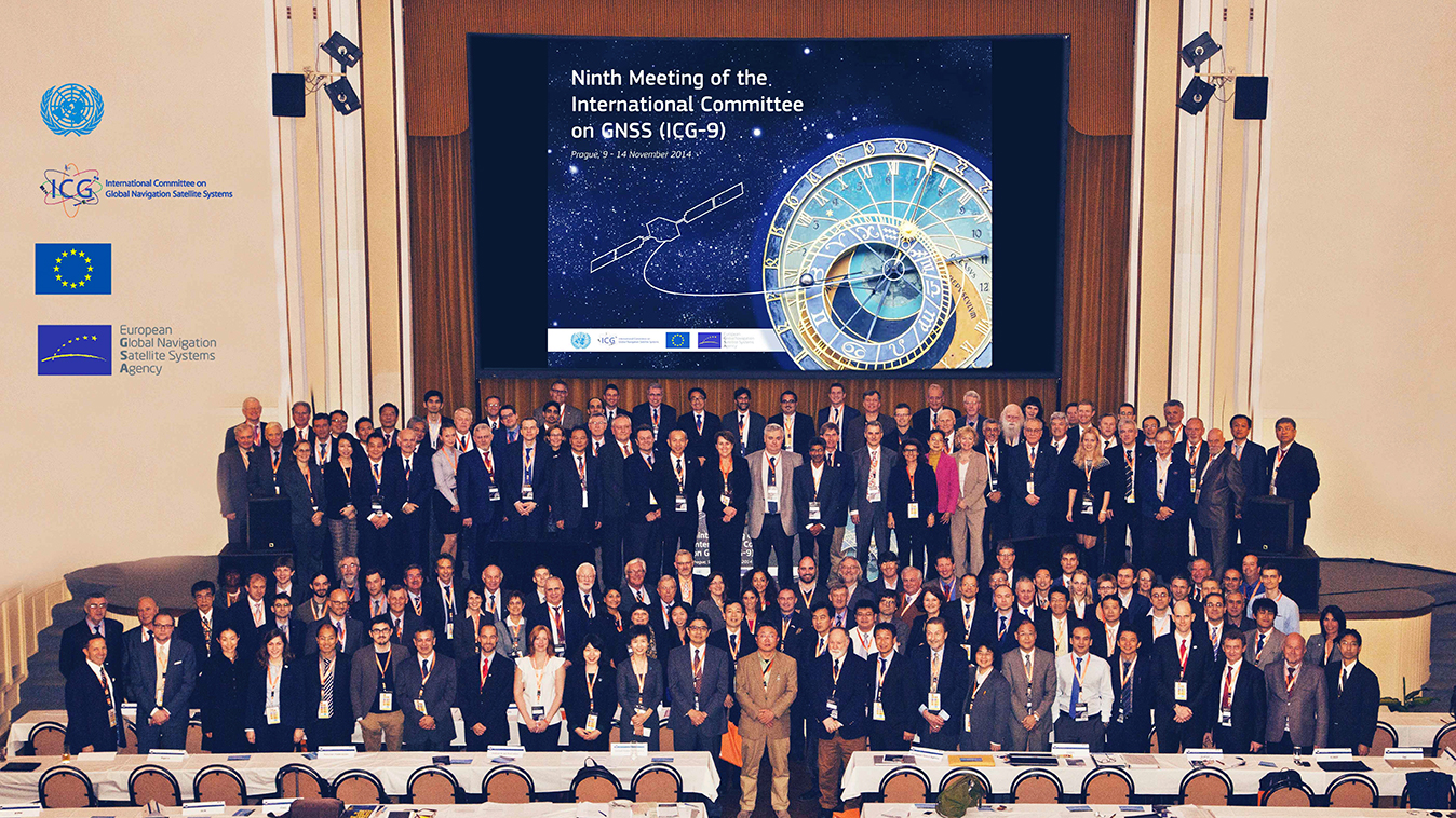
The European GNSS Agency (GSA) hosted the ninth meeting of the International Committee on Global Navigation Satellite Systems (ICG) in November at its headquarters in Prague, Czech Republic. The event is an opportunity for GNSS providers to present the status and future plans for their systems, and an opportunity for ICG members, associate members, and observers to provide updates on recent developments with regard to GNSS services and applications.
Representatives from the world’s leading global and regional GNSS programs were invited to provide the assembly with a “state of play” for their respective systems. Joining GPS, GLONASS, BeiDou, IRNSS/GAGAN, and QZSS was Galileo, represented by Christian Siebert, Head of Unit, Galileo and EGNOS: Applications, Security and International Cooperation, DG Enterprise and Industry, European Commission.
A Secure Foundation
The key message coming from Prague was that, despite the launch anomaly in August, the Galileo program has a secure foundation for moving forward. For instance, it has been given a stable seven-year perspective, a substantial budget, and a new exploitation-driven governance scheme. In terms of budget, the European Commission has allocated €1.930 billion for deployment and €3 billion for exploitation — with an additional €1.580 billion allocation for European Geostationary Navigation Overlay Service (EGNOS) exploitation.
The new governance scheme is based on a recently announced agreement between the European Commission and the GSA; the agreement delegates a range of exploitation tasks for Galileo to the GSA. Serving as an initial step towards the full Galileo Exploitation Phase, the GSA’s responsibilities now include:
provision and marketing of the services;
management, maintenance, continuous improvement, evolution and protection of the space and ground infrastructure;
research and development of receiver platforms with innovative features in different application domains;
development of future generations of the system;
cooperation with other GNSS;
all other required activities to ensure the development and smooth running of the system.
This new budget and governance structure ensures the Galileo program’s stability for the next seven years, according to a GSA press release. The agency will progressively manage exploitation activities as delegated by the European Commission, which serves as the program’s supervisor.
At the same time, the European Space Agency (ESA) will continue its role for system design and development.
A Range of Successes
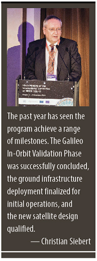
“The past year has seen the program achieve a range of milestones,” said Siebert. “The Galileo In-Orbit Validation Phase was successfully concluded, the ground infrastructure deployment finalized for initial operations, and the new satellite design qualified.”
Even with the satellite launch anomaly that left two satellites in the wrong orbit, the ESA just announced that one of these satellites will soon make a series of maneuvers as a prelude to its health being confirmed. The aim is to raise the lowest point of its orbit — its perigee — to reduce the radiation exposure from the Van Allen radiation belts surrounding Earth, as well as put it into a more useful orbit for navigation purposes. If the operation is successful, the second satellite will follow suit.
As to the cause of the anomaly itself, Siebert said Arianespace has established an inquiry board to investigate, and the European Commission and ESA continue to analyze the best options for recovering the initial mission to the best possible extent. A new launch sequence will be confirmed in the near future.
That being said, the deployment plan for the Galileo constellation is secured, with 26 satellites ordered (four IOV and 22 FOC) and launcher service contracts for the full constellation signed with Arianespace. As to the new satellite design, production proceeds at a good pace, with full operational capability (FOC) satellites being built by OHB Systems and navigation payloads provided by Surrey Satellite Technology Ltd.
In terms of services, the Search and Rescue Forward Link Alert Service successfully tested the networked ground segment last April, and positioning accuracy exceeds expectations.
As to the Commercial Services Demonstrator, the main objective of the demonstrator was to test and characterize the high accuracy and authentication performance obtainable with the Galileo Commercial Service. The first results are extremely promising, with high accuracy already demonstrated through PPP information transmitted via E6B and used to enhance both Galileo and GPS.
Siebert noted that the ongoing Receiver Test Campaign supports manufacturers to ensure that Galileo is well implemented in chipsets and receivers. To accomplish this, the program continues to develop dialogs with the user/receiver segment to understand the market situation and follow up adoption of Galileo.
Looking Ahead
With this secure foundation, looking towards 2015 and beyond, Galileo is set to deliver a reliable, high-quality service to the world, according to EC and ESA spokespersons presenting at the ICG. “With its substantial budget and exploitation-focused governance scheme, it will continue to evolve and introduce innovative features,” Siebert affirmed.
Next steps for the program include a gradual introduction of the early phase of service delivery, which will rely heavily on interaction with users. Early services will be run with continued infrastructure deployments. The program will soon conduct a service validation campaign, along with finalizing the Commercial Service definition and developing a long-term service plan.
“This service plan will be aligned with the trend of most user communities moving towards service levels based on a multi-constellation approach,” concluded Siebert. “Knowing this, it is crucial to continue to improve signal compatibility and interoperability of the Galileo service with other providers and cooperate on building multi-constellation programs.”
As European satellites offer a possibility to improve the efficiency of train control systems, GNSS technology is starting to gain momentum in the rail sector. To promote the role of GNSS in this important sector, the European GNSS Agency (GSA) recently exhibited at Innotrans — a leading rail transport tradeshow.
EGNOS can and, in the future, Galileo will provide continuous and highly reliable positioning service — helping increase the competitiveness of rail among other modes of transportation. Currently, GNSS in European rail is primarily used within non-safety-of-life applications, including asset management and passenger information services. However, the latest technological developments show that augmented GNSS, together with specific sensors, can help satisfy the stringent CENELEC Safety and Integrity Level requirements.
As a result, the rail sector has an increasing demand for cost-effective and innovative GNSS applications for both safety critical and non-safety critical purpose. For example, in the safety-critical domain, GNSS-based applications can provide signaling and autonomous train control. In the non-safety critical domain, GNSS is helping improve the performance of asset management and passenger information systems.
Showcasing the E-GNSS Advantage
With rail becoming an important market segment for GNSS technology, and to put emphasis on the many benefits E-GNSS can bring the rail sector, for the first time the GSA exhibited at a rail tradeshow. At Innotrans, one of the leading international tradeshows for the sector held September 23-26 in Berlin, the GSA showcased the EGNOS advantage for rail.
Joining a panel discussion hosted by the European Railways Agency (ERA) entitled “How Heaven Could Support European Train Control System (ETCS),” GSA Head of Market Development Gian-Gherardo Calini explained how European GNSS can serve as a solution to some of the problems the sector currently faces.
“Although rail will become a major market for E-GNSS, it is already providing benefits, such as helping to improve safety,” he said. “Our role at the GSA is to serve the end user by making sure the technology delivers the necessary solutions.”
Calini acknowledged there are challenges to the sector’s full adoption of GNSS, but stated that other sectors have overcome challenges and are benefiting from E-GNSS: “It is a successful reality in other transport sectors, especially aviation, and we must focus on building from these experiences,” he said.
The ERTMS/ETCS is a major industrial project that aims to replace Europe’s different national train control and command systems. The deployment of ERTMS will enable the creation of a seamless European railway system with aligned signalling — essential to increasing the competitiveness of European railways.
Europe’s GNSS systems — Galileo and EGNOS — are actively contributing to the needed evolution of the ERTMS. One example of this long-term perspective is the Shift2Rail Joint Undertaking, whose objective is also to support the adoption of GNSS in the rail sector. Within this undertaking, it is foreseen that both Galileo and EGNOS will be brought into ERTMS standards and foster European GNSS adoption in the area of Low Density Lines.
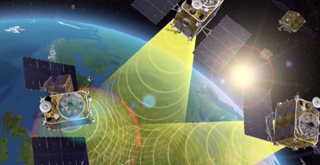
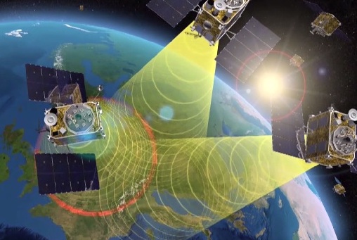
EGNOS is Europe’s first venture into satellite navigation. EGNOS broadcasts augmented information through a trio of geostationary satellites linked to a network of monitoring ground stations, to sharpen the accuracy and reliability of GPS signals across the continent. Photo: EGNOS
Europe’s EGNOS augmentation system sharpens the accuracy and reliability of GPS signals so they can safely be used for landing approaches across a growing number of European airports. But aviation is a global enterprise — so the aim is to develop a seamless network of augmentation systems in future.
That is the task of an international group of experts, the Satellite Based Augmentation Systems (SBAS) Interoperability Working Group (IWG), whose 27th meeting took place in Tampa, Florida, September 8-10, hosted by the Institute of Navigation.
Satellite augmentation systems combine dedicated ground stations and satellite transponders to sharpen satnav accuracy and provide integrity data — providing continuously updated reliability levels — across given geographical regions. These systems are based on GPS for now, but plans are to move to a multi-constellation design in the post-2020 era, making use of Europe’s Galileo, China’s Beidou and Russia’s GLONASS systems as well.
SBAS providers from around the globe gathered at Tampa, Florida, for the latest meeting of the SBAS Interoperability Working Group September 8-10. IWG 27 was hosted by the Institute of Navigation. Photo: SBAS
SBAS systems enhance any type of location-based satnav use, but in practice, aviation is the main driver. The ESA-developed European Geostationary Navigation Overlay Service, EGNOS, commenced its general-public Open Service in 2009, with the Safety-of-Life Service for aircraft vertical landing approaches following in 2011.
For next-generation SBAS systems, the IWG is designing a multi-constellation and dual-frequency standard for heightened accuracy and reliability, building up to offering SBAS coverage on a worldwide basis.
Didier Flament, representing ESA — which co-chaired this IWG meeting with the U.S. Federal Aviation Authority — commented: “Among the achievements of the Tampa IWG has been the presentation of an ongoing review of a standard message definition for the new and second SBAS channel — known as L5 — of the second-generation SBAS system, to be used along with the current L1 signal.
ASECNA Member States.
“A single definition coordinated between ESA and the European Commission on one side and the U.S. Federal Aviation Administration on the other is progressing. The formal IWG review loop has started, with the aim of finalizing the convergence for early 2015. The aim is to have it ready to submit to the international SBAS standardization bodies — the International Civil Aviation Organization (ICAO), the U.S. Radio Technical Commission for Aeronautics and the European Organization for Civil Aviation Equipment — in the first quarter of next year.”
The meeting also introduced two new SBAS development projects, adding to the five existing projects presented at IWG 26. The first was presented by the Agency for Air Navigation Safety in western Africa and Madagascar (ASECNA), a public international organization with 18 member states.
China’s BeiDou SBAS development plan, presented at IWG 27 in September 2014.
ASECNA’s project aims to take a two-step approach, commencing with EGNOS-style vertical landing guidance for selected airports, based on EGNOS constituents, with a tentative schedule of 2018, moving to upgrade to the dual-frequency multi-constellation service across the whole of ASECNA airspace after 2020.
The second new project is China’s own BeiDou SBAS. After discussions at ICAO level, China has committed to delivering SBAS services over China that are fully compliant with ICAO standards.
“This new plan has been highly welcomed by the aviation community and other SBAS providers,” Didier said. “Chinese representatives have also confirmed their intention to become part of the SBAS IWG and contribute to the work done to finalise the future standard.”
The follow-up IWG meeting will take place in February 2015 and will be hosted by ASECNA in Dakar, Senegal.
About EGNOS
EGNOS, the European Geostationary Navigation Overlay Service, is Europe’s first venture into satellite navigation. Its development was managed by the European Space Agency (ESA) under a tripartite agreement with the European Commission (EC) and the European Organization for the Safety of Air Navigation (Eurocontrol).
The ownership of the EGNOS assets was transferred from ESA to the EC in April 2009 and EGNOS officially entered service on October 1, 2009. The service is delivered, through a contract with the European GNSS Service Agency (GSA), by the European Satellite Services Provider, ESSP SaS, founded by seven air navigation service providers. ESA is the design and procurement agent for EGNOS on behalf of the EC.
On October 21, Jordan will host a Euro-Mediterranean Partnership (EUROMED) regional event focused on the use of GNSS, particularly European GNSS, for freight and road transport. The Euromed GNSS II/MEDUSA meeting will be held in Amman, Jordan, at the Sheraton Al Nabil Hotel.
Organized by the Euromed GNSS II/MEDUSA project, under the auspices of the Ministry of Transport of Jordan, the event will aim to share experiences and best practices, and to discuss strategies and possible ways forward in relation to the use of the satellite navigation for freight and road transport in the region.
At the event, MEDUSA will present the results of its case study, which was conducted with Royal Jordanian Customs and with the aid of the Ministry of Transport of Jordan. Since April, supported by European companies involved in MEDUSA, Royal Jordanian Customs have had the opportunity to test and validate the use of European GNSS, and specifically of EGNOS, for tracking and tracing containers shipped across the Mediterranean Sea and vehicles transporting goods in Jordan.
The case study is one of the technical assistance actions implemented by MEDUSA, and it represents the first life experience of EGNOS services’ usage in areas distant from Europe.
MEDUSA belongs to the EU Euromed Transport Program. Its objective is to promote the adoption of the European GNSS by the Euromed countries, which include Algeria, Egypt, Israel, Jordan, Lebanon, Libya, Morocco, Palestine, Syria (suspended due to political unrest), and Tunisia.
GNSS technology is applied to several user applications, and transport is one of the most important, including aviation, road, maritime, rail, freight transport and logistics. The MEDUSA project includes a program of specific technical assistance actions for the Euromed countries, to facilitate the introduction and exploitation of GNSS services in their markets.
The wide adoption of advanced technology, also including satellite navigation, for freight and road transport applications (such as Intelligent Transport Systems, or ITS) enables the implementation of smart mobility and the enhancement of goods transportation/traffic volumes increasing.
During the event, the participants from the Euromed countries will share lessons learned from the Jordan case study, and learn about relevant best practices in Europe and in the Euromed region, as well as debate strategies and possible ways forward in the light of national interests and common regional perspectives.
Opened by an institutional panel, with representatives of the Jordan Ministry of Transport and the European Commission, the event will consist of a session dedicated to the case study and a session addressing opportunities in other Euromed countries, including the presentation of European success cases as examples of suitable paths to guide the GNSS operational introduction and adoption.
At the conclusion of the event, the participants will elaborate guidelines and recommendations, to be possibly translated into action plans for the Euromed countries.