Tag: EGNOS

  • EUSPA grants Thales Alenia Space framework contract to build European GNSS Demonstrator

    EUSPA grants Thales Alenia Space framework contract to build European GNSS Demonstrator

    EUSPA has signed a Framework Contract with Thales Alenia Space to build the European GNSS Service Demonstrator (ESD), a centralized modular platform advancing EU Space services like EGNOSGalileoCopernicus, and GOVSATCOM/IRIS2.

    This EGNSS Service Demonstrator is a key innovation accelerator for EUSPA, paving the way for large-scale end-to-end testing future Galileo and EGNOS augmentation services through both geostationary satellite and internet-based dissemination.

    The system will serve as the backbone of pre-operational EGNSS service validation, anticipating future positioning, navigation and timing (PNT) user needs across critical markets, support standardization activities, and sustain EUSPA’s commitment to service excellence.

    Building on Thales Alenia Space’s track record in PNT satellite-based services, the EGNSS Service Demonstrator project inherently anchors Thales Alenia Space at the forefront of the new generation of GNSS-based applications and services for millions of European and global users.

    Capabilities

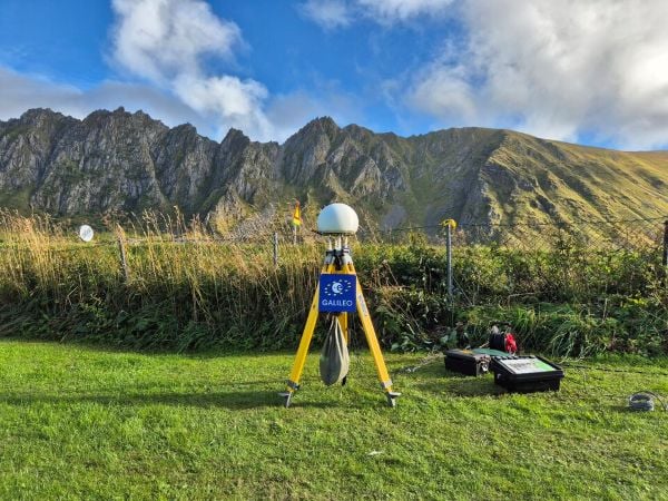
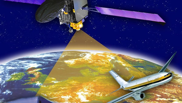
    The ESD will comprise modular and flexible ground and support segments to handle a diverse number of reference stations and data. It will be able to compute corrections, messages or data that will be disseminated in real-time via different means such as GEO SiS and the internet.

    It centralizes EGNSS demonstrations, incorporating future services like high accuracy (HAS), authentication (OSNMA, SAS), maritime/rail DFMC safety, space weather and emergency warning via scalable infrastructure.

    Strategic role

    The ESD will facilitate the seamless rollout of new/improved services without disrupting operations of current EGNSS services, emulating signals for realistic testing to support future prototyping and standarization of receivers (such as for rail safety or automotive high-accuracy units), and app development. It will refine user needs across sectors while engaging users and developers.

    Key use cases

    The main use cases that the ESD will cover are:

    • Early Open Service signals, such as pre-operational EGNOS DFMC SBAS or Galileo HAS integrity, to accelerate user readiness.
    • Service consolidation for evolutions like enhanced HAS via E-GSC interface, OS-NMA/SAS testing, and sector-specific apps (maritime, rail).
    • Standardization support for receivers like MUGG, EDG2E and Fundamental Elements projects; SBAS promotions and demos.

    With the European GNSS Service Demonstrator, EUSPA strengthens Europe’s ability to test, evolve and deploy future EU Space services, supporting innovation, standardization and market uptake while ensuring service continuity and resilience.

  • SES extends EGNOS GEO-1 satellite service to power precise navigation across Europe

    SES extends EGNOS GEO-1 satellite service to power precise navigation across Europe

    The agreement ensures Europe’s satellite-based augmentation continues enhancing navigation for aviation and other critical users and lowering emissions.

    SES, a space solutions company, and the European Union Agency for the Space Programme (EUSPA) have announced an extension of the European Geostationary Navigation Overlay Service (EGNOS) GEO-1 satellite service agreement through 2030, with an option to extend until 2032, helping maintain high-precision navigation services for aviation and other critical users across Europe.

    By improving the accuracy and integrity of satellite positioning signals, EGNOS supports aircraft in landing in low-visibility conditions, as well as planning more efficient routes, reducing fuel burn and CO₂ emissions.

    At the core of the EGNOS service is Europe’s regional satellite-based augmentation system (SBAS) that improves the accuracy and reliability of GNSS signals, such as GPS. Beyond aviation, EGNOS supports maritime navigation and precision-driven agriculture, contributing to efficient operations and sustainability by reducing fuel consumption and emissions.

    Under the extended GEO-1 contract, SES will continue operating an EGNOS-hosted payload on its SES-5 satellite, as well as the ground segment from its facilities in Europe.

    “This extension ensures a robust EGNOS space segment, ready for the transition towards its next version and the development of new services, while safeguarding high-precision navigation for aviation and other critical users across Europe,” said Rodrigo da Costa, EUSPA executive director.

    “EGNOS is a cornerstone of Europe’s aviation and broader navigation applications. The agreement underscores SES’ and EUSPA’s joint commitment to advancing satellite-based services that enable secure, reliable, and sustainable navigation solutions,” said Philippe Glaesener, senior vice president, Global Government at SES. “Thanks to the service, millions of users and operators will benefit from efficient and more reliable air transportation services across all of Europe. This commitment reflects our broader mission of delivering resilient satellite solutions for critical infrastructures.”

  • ESA celebrates 30 years of Galileo

    ESA celebrates 30 years of Galileo

    To celebrate 30 years of the Galileo global navigation system, the European Space Agency created the following video. Astronomer Galileo Galilei makes an appearance.

    “Three decades of challenges and triumphs that have shaped the navigation systems we rely on today: EGNOS and Galileo, and that serve as a legacy to building the satellite navigation systems of tomorrow,” states ESA.

     In October 1995, the ESA Council at Ministerial Level approved ARTES Element 9, initiating the studies and development of GNSS-1 (EGNOS) and GNSS-2 (Galileo). However, the first steps leading to this moment started as early as the 1980s, with pioneering research and studies conducted by ESA, national space agencies and European institutes.

    Learn more about the history of Galileo.

  • ESA honors Rohde & Schwarz for contributions to satellite navigation over 30 years

    ESA honors Rohde & Schwarz for contributions to satellite navigation over 30 years

    The European Space Agency (ESA) marked 30 years of European satellite navigation with a celebration Sep. 2 at its research and technology center. The event honored key contributors who have shaped the journey of systems like Galileo and EGNOS, which have positioned Europe as a global leader in satellite navigation.

    Among the honorees was Rohde & Schwarz, recognized for the excellence, commitment and long-standing partnership leading to the success of European satellite navigation programs over the past three decades.

    Javier Benedicto kicks off the celebration of 30 years of satellite navigation. (Photo: ESA)
    Javier Benedicto kicks off the celebration of 30 years of satellite navigation. (Photo: ESA)

    The event brought together institutional and industrial partners, ESA Member State representatives, and leading figures in satellite navigation. The celebration revisited pivotal milestones in Europe’s satellite navigation history and looked ahead to future innovations.

    A highlight of the evening was the award ceremony led by ESA Director of Navigation Javier Benedicto, who, alongside past directors, presented accolades to organizations and partners instrumental in this success story.

    Rohde & Schwarz’s recognition underscores their role in advancing European satellite navigation technology. Their contributions have been vital in the development and operational success of Galileo and EGNOS, systems that have revolutionized positioning, navigation, and timing services across Europe and beyond.

    The event not only celebrated past achievements but also set the stage for the future of European satellite navigation, with discussions around upcoming initiatives and advancements. For Rohde & Schwarz and other honourees, the evening served as both a celebration of past achievements and a call to continue building a connected, resilient, and sustainable future in space.

    “Thirty years of satellite navigation is a testament to shared vision, determination to push technology boundaries, and intense, long-term collaboration,” said Rob Short, director of Business Development at Rohde & Schwarz. “We are honoured to have contributed to this remarkable achievement. Congratulations to everyone who made this milestone possible.”

  • ESA fights interference in Arctic tests

    ESA fights interference in Arctic tests

    News from the European Space Agency

    In its pursuit of strengthening European resilience in navigation, the European Space Agency (ESA) took part in Jammertest. Jammertest 2025 brought together 360 participants from 120 organisations across more than 20 countries, spanning academia, industry and governmental institutions.

    Incidents of deliberate GNSS interference are on the rise, wih attacks happening daily worldwide. Disruptions threaten safe operations of energy grids, banking infrastructure, emergency transportation and civil aviation, with an outage potentially costing billions of euros daily for Europe.

    Bleik on the island of Andøya offered a suitable setting for Jammerfest. (Image: ESA)
    Bleik on the island of Andøya offered a suitable setting for Jammerfest. (Image: ESA)

    Jammertest. In a complex coordination exercise among seven Norwegian public authorities and facilitator Testnor, Jammertest organisers broadcast real satellite navigation interference for participants to observe how their equipment (on vehicles, drones, aircrafts, helicopters and vessels responds.

    At nearly 70 degrees North and 300 km inside the Arctic Circle, the small village of Bleik on the island of Andøya offers the ideal setting for Jammertest. To the east, towering mountains act as natural barriers that contain disruptive signals, minimising their impact on civil society. To the west, its open coastline allows signals to be transmitted over the sea, supporting maritime participants in addition to air and land users.

    The event’s test catalogue is extensive. Organisers simulate everything from simple handheld jamming to complex multi-source attacks launched from several locations simultaneously, including from mountaintops. “The goal is that every receiver is knocked out at some point during the campaign,” explains Tomas Levin, senior principal engineer at Norwegian Public Roads Administration and head of Jammertest.

    “At Jammertest, the full GNSS chain sits along a table, from chip manufacturers to those developing the algorithms that run on them, to the companies building products around those chips and the ones integrating these products into larger systems,” Levin said.

    Photo:
    ESA’s navigation and telecommunications testbed vehicles are custom-built mobile test platforms operated by ESA’s Navigation Laboratory to support test campaigns for navigation and telecommunications services, most notably Europe’s Galileo constellation. (Photo: ESA)

    ESA engineers arrived with several missions. As in previous years, the team tested the robustness of EGNOS and Galileo signals when picked by a range of antennas, from simple mass-market ones found in smartphones to military-grade antennas, both stationary and mounted on a moving van.

    A key objective was to test the performance of novel receiver technologies developed under various ESA programs, comparing them to current technologies. The team also tested equipment provided by industrial partners under ESA’s Third-Party services.

    More than 100 TB of data were recorded and will support internal research. Moreover, these data can now be replayed at the ESA Navigation Laboratory, allowing industry to analyse how new equipment responds to real-world interference scenarios. (If you are interested in using ESA’s NavLab testing and consultancy services, fill out the contact form on the Consultancy and Testing page).

    Finally, ESA also oversaw tests of new EGNOS ground receivers being developed by European industry under Horizon2020 and Horizon Europe programmes. These receivers aim to improve the system’s robustness in its next generation.

    Multi-beam satellite navigation antenna test. (Photo: ESA)
    A multi-beam satellite navigation antenna test. (Photo: ESA)

    Several projects tested at Jammertest by other participants were funded through NAVISP, highlighting the agency’s role in fostering innovation across the GNSS ecosystem. 

    “Jammertest is a unique opportunity,” concludes Derambure. “Here we have the edge of technology, the edge of testing scenarios. There is nowhere else where we can test this material in real conditions. I believe Jammertest will become a mandatory step for any new satellite navigation receiver technology.” 

  • EGNOS satellite upgrade strengthens European navigation services

    EGNOS satellite upgrade strengthens European navigation services

    The GEO-3 satellite Eutelsat 5 West B (PRN 121) is now part of the European Geostationary Navigation Overlay Service (EGNOS) operational platform and broadcasts the Operational Signal-in-Space.

    PRN 121 began broadcasting operational signals Aug. 25 as part of EGNOS System Release 2.4.3. The upgrade seeks to strengthen service continuity and prepare the system for future enhancements.

    The transition involved swapping satellite roles within the EGNOS constellation. On Sept. 5, the GEO-2 satellite ASTRA 5-B shifted from operational to test status, creating a new configuration with GEO-1 and GEO-3 handling operational duties while GEO-2 serves as the test platform.

    The changes will not disrupt service or affect coverage areas, officials said.

    “Eutelsat is proud of its long-standing collaboration with EUSPA,” said Arlen Kassighian, chief engineering officer of Eutelsat. “We are delighted to host this payload, which will continue to significantly enhance the performance of global navigation satellite systems across Europe in the coming years.”

    The system release represents preparation for EGNOS V3, the next-generation platform that will offer enhanced performance, improved robustness and dual-frequency multi-constellation capabilities for European satellite navigation services, according to Jean-Marc Pieplu, head of EGNOS Exploitation Department.

    The European Union Agency for the Space Programme manages the EGNOS space segment, system upgrades and service provision. The agency’s integration of the GEO-3 satellite ensures EGNOS continues providing reliable augmentation services for safety-critical and professional applications throughout Europe.

    Additional information is available in the EGNOS Service Notice.

  • Thales Alenia Space secures contract to extend EGNOS service life

    Thales Alenia Space secures contract to extend EGNOS service life

    Thales Alenia Space — a joint venture between Thales and Leonardo — has secured a €51 million ($56 million) contract from the European Union Agency for the Space Programme (EUSPA) to extend the operational life of the European Satellite-Based Augmentation System (EGNOS).

    Named Life Extension Phase 1 (LIFEX), this contract will ensure that EGNOS V2 continues to provide reliable, secure and high-performance navigation services for Europe’s aviation, maritime, land transport, mapping and agricultural sectors beyond 2028.

    EGNOS system is designed to enhance the accuracy, reliability and integrity of positioning signals by improving the performance of GNSS, such as GPS and, in the future, Galileo. As part of this contract, Thales Alenia Space will address EGNOS V2 critical system upgrades and infrastructure improvements, reinforcing the system’s resilience and operational durability. These updates will focus on enhancing security measures, modernizing components, and ensuring the ongoing reliability of EGNOS’s Safety of Life Service, which plays a key role in aviation, enabling accurate approaches at European airports without requiring ground guidance systems. Operational since 2011, this service has significantly improved operational safety and efficiency for the greater benefit of European operators.

  • ESA releases plans for FutureNAV Industry Day 2025

    ESA releases plans for FutureNAV Industry Day 2025

    The European Space Agency (ESA) will host the first FutureNAV Industry Day on Feb. 18, 2025 — at ESTEC, the Netherlands — to address the growing demand for advanced positioning, navigation and timing (PNT) technologies. This event aims to bring together European stakeholders in satellite navigation to discuss future developments and foster collaboration within PNT and GNSS sectors.

    As the leading system developer and design authority for Galileo and EGNOS, ESA plays a crucial role in Europe’s satellite navigation landscape. The agency launched the FutureNAV program in 2022 to unify efforts in advancing navigation technologies. Two key missions under this initiative are low-Earth orbit (LEO) PNT, which will demonstrate the potential of navigation satellites in LEO and Genesis, which will combine four geodetic techniques in one satellite to improve Earth’s reference frame.

    FutureNAV Industry Day seeks to provide attendees with insights into ESA navigation plans and potential opportunities for European industry. It will follow a Request for Information on LEO-PNT industrialization, gathering information on European production capabilities for payload building blocks and satellite platforms.

    To complement these upstream initiatives, the Navigation Innovation and Support Programme (NAVISP) Industry Days will be held at the University of London on March 4-5, 2025, focusing on downstream applications and bringing together industry leaders and innovators.

    Click here to register and learn more about the event.

  • SparkFun Electronics launches GNSS RTK module for positioning accuracy

    SparkFun Electronics launches GNSS RTK module for positioning accuracy

    SparkFun Electronics has introduced the SparkFun Quadband GNSS RTK Breakout (Qwiic), which is designed to improve positioning accuracy using the Quectel GNSS module. This module has a compact design and compatibility with the Qwiic connector, making it easy to integrate into various projects. Additionally, it shares the same dimensions, pin layout and connectors as the SparkFun GPS-RTK-SMA Breakout – ZED-F9P, offering a seamless upgrade path for users.

    The LG290P module is a quad-band, multi-constellation, high-precision real-time kinematics (RTK) GNSS receiver capable of receiving signals from multiple frequency bands: L1, L2, L5 and L6/E6. It supports all GNSS constellations and offers support for Satellite Based Augmentation Systems (SBAS) — such as Wide Area Augmentation System (WASS) and European Geostationary Navigation Overlay Service (EGNOS) — as well as precise point positioning (PPP) services, including BDS PPP-B2b and MADOCA-PPP. The module is designed to provide precise navigation with fast convergence times and reliable performance through RTCM and RTK corrections.

    The module features a built-in NIC anti-jamming unit, which uses advanced algorithms to detect and eliminate interference signals. This can significantly enhance signal reception in challenging electromagnetic environments. The device can be used in complex scenarios, such as urban settings or areas with dense tree cover. Due to its high precision and low power consumption, the SparkFun Quadband GNSS RTK Breakout – LG290P is ideal for applications in intelligent robotics, UAVs, precision agriculture, mining, surveying and autonomous navigation.

  • GMV to oversee GOVSATCOM hub for EU satellite communications initiative

    GMV to oversee GOVSATCOM hub for EU satellite communications initiative

    Photo: GMV
    Photo: GMV

    The European Union Agency for the Space Programme (EUSPA) has awarded a contract to a consortium led by GMV to design, develop and deploy the communications hub for the Governmental Satellite Communications (GOVSATCOM) programme. This contract, valued at up to €107 million ($119 million), is a critical component of the European Union (EU) satellite communications initiative.

    GOVSATCOM is one of the five main components of the EU Space Programme, alongside Copernicus, Galileo, EGNOS and Space Situational Awareness. Its primary objective is to provide secure and cost-efficient satellite communication services to authorized governmental users in EU Member States.

    The program aims to support various scenarios, including crisis management, border and maritime surveillance, critical infrastructure management and security operations in polar regions.

    The communications hub is a critical element of the GOVSATCOM architecture. Its main functions include:

    • Ensuring optimal delivery of satellite communication services
    • Meeting the demand for operational services from EU Member State users
    • Planning for predefined medium-term communication needs
    • Handling dynamic and urgent requests from unforeseen scenarios
    • Operating under strict security and resilience requirements

    The hub will manage satellite communication resources from EU Member States and services provided by the EU’s future multi-orbital secure communications constellation, IRIS2.

    The consortium led by GMV includes Indra and Hisdesat. The contract was awarded following a competitive bidding process involving pre-selection consortia and execution of parallel contracts for preliminary design and capability demonstrations.

  • EGNOS releases Safety of Life updates

    EGNOS releases Safety of Life updates

    Photo: EGNOS
    Photo: EGNOS

    The European Geostationary Navigation Overlay Service (EGNOS) has released version 3.6 of its Safety of Life (SoL) Service for Aviation Service Definition Document (SDD), introducing several critical updates to enhance EGNOS satellite navigation-based operations.

    SDD v3.6 describes improvements in EGNOS architecture for the space and ground segments. For the space segment, the document presents the latest technical information on the geostationary (GEO) satellites that deliver EGNOS services. In the ground segment, the ranging integrity monitoring station (RIMS) network has been expanded to include a new site in Kuusamo, Finland. The addition of this station in the far northern reaches of Europe extends coverage and heightens the robustness of SoL service in this remote and challenging environment.

    SDD v3.6 also provides a detailed analysis of the impact of ionospheric activity during Solar Cycle 25, which began in December 2019 and is expected to peak around 2025. This extreme solar activity poses challenges to satellite navigation, and the document offers insights into how EGNOS maintains reliable performance under adverse ionospheric conditions.

    The new updates aim to improve the precision, reliability and safety of satellite navigation services in aviation. The SoL service supports various transport domains, primarily focusing on civil aviation, covering localizer performance with vertical guidance (LPV) procedures.

  • EUSPA launches EGNOS Safety of Life Assisted Service

    EUSPA launches EGNOS Safety of Life Assisted Service

    Image: EUSPA
    Image: EUSPA

    The European Geostationary Navigation Overlay Service (EGNOS), Europe’s regional satellite-based augmentation system (SBAS), has added Safety of Life Assisted Service (ESMAS) for maritime users. 

     Designed to complement ground-based augmented signals, ESMAS aims to add a layer of protection against GNSS signal errors while increasing signal accuracy and ensuring integrity. 

     While GNSS remains the primary means of obtaining positioning, navigation and timing (PNT) information while at sea, users in the maritime realm generally employ augmentation services provided by ground-based technologies such as Differential Global Navigation Satellite System (DGNSS), which correct GNSS errors to provide more accurate positioning information. 

    ESMAS is delivered via existing EGNOS space-based and ground-based facilities and does not require any additional infrastructure. It is well-positioned to support navigation on the open sea and in coastal waters, covering harbor approaches and entrances. 

     ESMAS is provided openly and is accessible without any direct charge. It is available via all satellite-based augmentation system (SBAS) enabled GNSS receivers developed following International Electrotechnical Commission (IEC) standards. With such a receiver, users can navigate with increased accuracy and get GNSS error warnings. 

    EGNOS also interfaces with NAVAREA coordinators to provide timely maritime safety information (MSI), including navigation warnings and other urgent safety-related messages that are broadcast to ships through conventional channels. 

    According to Rodrigo da CostaDa Costa, EUSPA executive director, ESMAS is targeted towards aiding merchant vessels, but it is also available to all other SOLAS-conforming vessels from EU Member member States states and EGNOS contributing countries, including Iceland, Norway and Switzerland. Unlike other EGNOS services — which are delivered by European Satellite Services Provider (ESSP) under contract with EUSPA, ESMAS is to be delivered directly by EUSPA.