I’m impressed, as always, by the engagement of our webinar audience. Questions are pouring in about the speakers’ presentations, in addition to knowledgable queries submitted before the webinar began. These events strike me as, hour for hour, the best professional education one can get, short of leaving the office for a week to attend ION GNSS+ or the institute’s other conferences through the year, or the European Navigation Conference or Intergeo or others of the like. And a webinar takes only an hour of your time! From the comfort of your desk! Or sofa, even.
Here are some of the questions posed, and brief digests of our experts’ answers. The panel included John Fischer, VP Advanced R&D at Orolia, assisted by Jon Sinden, product manager for Rugged PNT; Tim Erbes, CTO at Talen-X; and Carol Politi, CEO at TRX Systems.
Q: Role of Galileo Public Regulated Service (PRS) in GPS-disrupted environment? Particularly given NATO alliance and cooperation? Any more detail about use of other GNSS to make solution more robust?
A: The PRS is certainly low-hanging fruit for traditional partners to take advantage of both GPS and Galileo, and I imagine fielded solutions will soon start to show that. There are substantial benefits to be gained from use of other GNSS as well.
Q: Please discuss the hardened military aspects of coming GPS III signals and codes. How will the new GPS III constellation impact your products?
A: Block III alone is not enough to make this happen. A new M-code will eventually replace the SAASM M-code, and it will provide a true separation from the civilian signal, different from the current situation with M-code and C/A code. Already, a dozen or more IIF satellites are now transmitting it. But the upgrade has to happen in three places for it to become effective: the satellites, the user receiver — and this is a complex, extremely broad and varied picture in the military realm — and finally the ground control system. There have been some difficulties in deploying the new OCX. This is the biggest determining factor of when these new features will roll out.
Q: What is the potential role of other means of PNT: eLoran, Iridium STL, lidar, and so on?
A: ELoran a very good alternative, ideal from the point of view of diversity: terrestrial instead of satellite, high-power instead of low, other end of spectrum from GNSS. Orolia published a white paper on a holistic approach towards resilient PNT, discussing eLoran and STL; see our website.
There are additional opportunities for outside-the-box solutions, for example, the sensors aboard tanks for anti-missile defense systems. They could also be used for PNT. Networked data radios for crowdsourced PNT data.
“If timing is to become mission critical, redundant means of distributing timing information is essential,” according to NIST.
NIST hosted the “Time Distribution Alternatives for the Smart Grid Workshop” at its Gaithersburg, Maryland, campus on March 21. The information gained will inform future NIST, U.S. Department of Energy, national laboratories and private sector technical programs and strategic planning.
The workshop consisted of experts on both electrical power and wide-area time distribution. The experts came from industry, utilities, academia and government.
The findings cover desired future characteristics, targets, challenges and barriers to adoption of time distribution alternatives; and priority R&D areas for time distribution alternatives.
Potential alternatives to wide area distributed time synchronization include Enhanced WWVB (radio signal broadcasting), eLoran (hyperbolic radio navigation) and the IEEE Wide Area Precision Time Protocol (PTP – master slave clock synchronization).
Results of the workshop illustrate the need for alternatives to existing GPS timing systems as well as backup systems and many of the challenges that need to be addressed to develop and implement alternatives. Some of the overarching themes that emerged include the following:
While a number of potential alternative exist, they will require further infrastructure, research and concerted investment to implement and demonstrate their potential to replace, supplement, back up, or fill gaps in existing GPS systems.
Potential alternatives may need to be combined in ensembles to fill gaps, create the needed redundancies, and supplement GPS-based timing.
Future alternatives to GPS will need to have the same or better levels of accuracy, resilience, security, trustworthiness, and availability to supplant existing systems; a diversity of timing distribution systems may be needed (terrestrial, communication-based, wireless, etc.).
Dependency on space-based systems is currently strong due to their perceived reliability; there is limited awareness of the possible adverse impacts of timing failure events in such systems (and few backups exist).
Developing and using existing alternatives and new technologies, and integrating these with legacy systems will require standards and use cases to enable new technology, architectures, and interoperability among systems.
Better understanding of attack and failure threat modes is needed to estimate and demonstrate the true consequences of timing failures in systems based entirely on GPS.
In a technical report titled GPS Vulnerability released Sept. 15, the Alliance for Telecommunications Industry Standards (ATIS) renewed its call for an eLoran system to support telecom and other critical infrastructure in the United States.
As part of its “Recommendations to Assure Time for Telecom” the report says:
“An eLoran system (or equivalent) should be developed and implemented in the U.S. to provide a near-term alternative to GPS for the telecom system and other critical infrastructure. The physical and cyber security of eLoran transmission stations should be a consideration in their operation.”
ATIS termed its report “a major resource to help better understand and address a formidable telecommunications industry challenge: the vulnerabilities in the Global Positioning System (GPS).”
Requirements for precise time delivery have driven the industry toward the increased use of GPS and GPS-dependent technologies, it says. Yet this dependency has left the industry vulnerable to disruptions and manipulations of the GPS signal.
GPS Vulnerability (ATIS-0900005) provides insight into the sources of the most common problems with GPS and their impacts. The report also covers several mature proposed solutions that would satisfy telecommunications sector timing requirements.
“GPS disruptions have economic, financial and service impacts to carrier network operators, suppliers, cellular services as well as adjacent industries and government agencies that depend on a functioning wireless communications sector,” said ATIS President and CEO Susan Miller. “We believe that our report on this topic will contribute to solutions to help secure the delivery of time — a function critical to many sectors in our economy.”
Known vulnerabilities to deliver GPS time to a system include environmental phenomena, malicious interference and spoofing, incidental interference, adjacent band interference, poor antenna installations and rare but present GPS segment errors.
GPS Vulnerability discusses techniques to address these vulnerabilities as well as alternatives to GPS timing, with the goal of mitigating GPS vulnerabilities for the timing receivers used in the critical infrastructure.
Alternatives covered in the report include Navigational Message Authentication on modernized GPS civil signals, atomic clock time holdover, sync over fiber, eLoran, WWVB, terrestrial beacons and more.
Putin shows taste for spoofing
For several days in June, more than 20 ships reported problems with GPS reception in the Black Sea (see Expert Opinion column, August GPS World). Experts concluded the problems were probably the result of a spoofing attack in the area.
Norwegian journalist Henrik Lied of NRKbeta compared this with accounts of similar episodes near the Kremlin complex in Moscow, where tourists have reported their smartphones showing them at an airport outside the city.
Lied interviewed University of Texas professor Todd Humphreys about his theory that this is an effort to keep drones from flying in the area: “Several of us [researchers in GNSS] have concluded the Kremlin spoofing was likely trying to trigger UAV geo-fencing, which prevents UAVs from flying near airports,” Humphreys said.
A Moscow correspondent for the Norwegian Broadcasting Company reports that these GPS problems only tend to occur when President Vladimir Putin is in town.
Several of the ships spoofed in the Black Sea were sailing in the vicinity of the Russian premier’s Black Sea vacation home. Putin was actually in the area when the incidents occurred. This may indicate that Russian authorities are spoofing wherever the Russian president is located.
Humphreys said, “It’s long been assumed that Russia, China and other nations (including the U.S.) have the technology to carry out a spoofing attack. What’s surprising is Russia’s willingness to use it openly and somewhat indiscriminately. It does fit nicely into what has been called Russian disinformation technology.”
The day started like any other day. The land surveying crew loaded up their vehicle, equipment and marching orders to tackle the next project on the list.
This field party is like most surveyors across the globe — they are equipped with the latest surveying technology including GPS base and receivers, robotic total station and a UAS for aerial photography. These tools are necessary to be competitive in today’s surveying arena as speed and productivity are paramount to the success of the project and the company.
But on this day, any device with the ability to determine geographic location via satellite reception was rendered useless.
Today became known as the day that GPS went away.
How we became dependent on GPS
Let’s back up the story to the introduction of GPS and how our dependency on this technology came to be. With the invention of satellites culminating with the Russian effort to launch Sputnik, the United States became involved in a “race to space.” Our early efforts to use satellites were proven worthy with the successful ability to track submarines by reception of radio signals and trilateration.
Further enhancements through research resulted in the development and creation of the NAVSTAR satellite in 1978. By 1993, 24 satellites were in orbit to make the GPS system fully functional (NASA.gov).
Meanwhile, the Russians were committed to a satellite network for navigational purposes during the same time period. The first satellite, Kosmos-1413, was launched in 1982 with the full 24 satellite constellation becoming operational in 1995.
Together, these systems (known as global network satellite systems or GNSS) allowed for location and navigation abilities never thought possible, and the surveying community began its adoption of the technology.
Early survey adopters of GPS were usually large engineering firms, state departments of transportation (DOTs) and federal agencies that could afford the large financial commitment to the equipment (both GPS and computers), software and computing costs required to use the technology.
The data-collection times were long, and the software analysis required enormous patience and extensive mathematical knowledge, but the results were beyond what the everyday surveyor had ever before accomplished.
Significant distances could now be measured with the same or better accuracy than taping or using an electronic distance meter could have provided. The true revolution came when real-time kinematic (RTK) GPS was invented and was affordable to the everyday surveyor (GPS World, May 2016).
S/A and A-S
Most GPS users, especially operators of survey-grade receivers, are not aware of the early days of satellite navigation and the military’s use of selective availability, otherwise known as S/A (GPS World, Sept/Oct 1990). This methodology was implemented by the Department of Defense (DoD) on May 25, 1990 to limit accuracies for non-military GPS users.
This procedure was created to allow erroneous timing at random occurrences throughout transmission of satellite radio signals. These variations in timing more than negatively tripled the normal precision of an autonomous GPS position calculation, all in the name of introducing uncertainty to potential enemy users.
And if S/A wasn’t enough, the DoD also could implement another deterrent called anti-spoofing (A-S) and encrypt the precision or P-code of the satellite signal. The big factor here is that the general public (in our case, the surveying community) didn’t know if or when A-S was turned on. These factors were frustrating to the GPS user, so data collection and coordinate determination became a tedious operation.
Early receiver use by surveyors relied on differential GPS data collection for high-accuracy location (<10 cm or better). This method consisted of placing one or more receivers on known positional points (usually on monuments published through the National Geodetic Survey) while simultaneously performing data collection on new points for positional establishment.
Prior to S/A, the software utilized to analyze and reduce the data collection provided feedback on “bad” data, but there were usually environmental issues causing the problem (such as cycle slips and radio interference.) The software would highlight the suspect data for the reviewer to determine validity and acceptance.
Because of the nature of differential GPS data collection, error checking remained the same once S/A was implemented. If the software calculated an incorrect coordinate at a known point, the same measurements to the new survey point were dismissed as a false reading.
Surveyors were mostly left unfazed by S/A as real-time kinematic (RTK) and real-time network (RTN) follow a similar procedure utilizing a correction from a known terrestrial point. Even with the anti-spoofing activated, the surveying profession continued to use this high-tech location system that revolutionized long distance measurement. Things have been running along smoothly with steady improvement of receivers, data collectors, and data coverage until…
The day it goes away
…the unthinkable happens. Our national satellite system is no longer available.
It doesn’t matter why GPS has gone away on this day. It could be for many different reasons: federal budgets; enemy interference such as geomagnetic disturbances (GMD) or electromagnetic pulse (EMP);
conventional or nuclear war; interference from solar storms, asteroids, or comets; or the system just simply breaks.
Artist’s rendering of a cross-section of the Earth’s magnetosphere. (IMAGE: NASA)
Another thing for all users of GNSS to consider in these tumultuous times is how newer systems are integrating other countries’ satellite networks into their navigational observations.
Our relationship with the Russian government can be on unsteady ground from time to time, so our use of their GLONASS signals must be reviewed for accuracy as well (See GPS World, August 2017).
It won’t matter whether a spoofed satellite signal originates from a private Russian hacker or from their actual government; it will still lead to incorrect information and bad data. Imagine having to revise a plat because the GLONASS data was purposely corrupted!
Obviously, the main reason they would allow transmittal of misinformation would be for military reasons, but I can only imagine their joy of messing with professional navigation and the recreational users in the U.S. These opportunities will also apply to the Chinese and Indian constellations, too.
We’re not ready
The bottom line is that we, the U.S., aren’t ready for it. Whatever may be the reason for the failure, we do not have a backup plan and have relied much too heavily on satellite navigation. Gone is our ability to navigate through our electronic devices, including smartphones, fitness trackers, in-car mapping and, yes, high-precision surveying equipment. These items have now become door stops and space wasters.
This new conundrum doesn’t just stop with the surveyor and recreational GPS equipment. A significant amount of construction equipment relies on machine control, from bulldozers and road graders to high-rise cranes.
This will also affect a large amount of agricultural equipment and processes. Those high-tech tractors with autosteer and computer-guided planters? Back to the drawing boards. So many things in our lives today are guided or controlled by navigational systems designed around GPS use, and the surveyor is squarely in this mix.
What’s a surveyor to do?
The first thought on the surveyor’s mind is now having to perform all surveying tasks with instruments that are not based on satellite navigation. Yes, the reason for this GPS shutdown isn’t widespread enough to affect cellphone signals and other radio communications, but it killed off the one navigation system more people rely on than any other.
Because of this unfortunate shutdown, all GPS-based equipment is now worthless. This means your trusty RTN receiver with cellphone connection, your old base unit for those times when cellphone coverage is lacking, the fancy new UAV for taking orthophotography, and your cellphone or handheld GPS receiver for tracking down NGS monuments — all of them are done. Only your conventional equipment will complete the job.
Is the surveying profession finished? How do we locate those remote section corners in the middle of nowhere?
Don’t throw in the towel just yet. Surveyors have been measuring land using these types of instruments for centuries, with today’s versions being electronic and sophisticated. Robotic servos, mini computer-data collectors, efficient radio links and active tracking prisms have turned our forefathers’ simple transit into a sophisticated topographic or construction staking machine.
Data collection is much easier than writing everything in a field book, and have graphical interfaces and remote connection capability to keep you in touch with the office from nearly anywhere. The reality, however, is that the surveyor will now have to use methods and equipment for traversing, data collections and all staking tasks that will greatly reduce our productivity and profitability.
Experience could also end up being a big factor here as well. The average age of the professional land surveyor in the United States is 58 and climbing. This means most of these practitioners have been in the business well before GPS technology, so there is still the potential of surveying without the electronic birds in the sky.
Surveyors can still hang their shingle and practice their craft, but we’ve now lost a big component of our world: geographical location. The key to the success of GPS was the ability to determine geographic location and subsequently convert that information into a data format compatible with one’s local system. From UTM coordinates to State Plane, the world became smaller with this technology.
The surveyor can still determine latitude and longitude using manual surveying methods for specifically observing the sun and Polaris. The mathematics and procedures are complicated, but they still allow for determining a geographical location with high accuracy.
We can also utilize the extensive geodetic monumentation networks established nationwide, all started around the formidable effort by the Coastal and Geodetic Survey. This key federal agency, later to become the National Geodetic Survey, laid the groundwork and set the monuments for the backbone of our national horizontal network system. This system has been augmented over the years by their own programs, as well as state and local authorities, to expand our coverage to all portions of the United States.
By incorporating these monuments into a survey, a relationship to geographical datums is still easily obtained. While these methods of establishing geographical coordinates through use of conventional equipment sounds time consuming, without GPS and other satellite-based navigational aids, it will become much more cumbersome.
So, what do we do next?
Depending on which industry you are in or your necessary level of accuracy, several alternatives are being developed. For those in the shipping industry (including the trucking sector, which numbers more than 15 million vehicles), accuracy may only need to be nominal — for instance, 5 meters, give or take.
Several systems are in development with the biggest priority on enhanced loran (short for “long range navigation”) or eLoran (also see GPS World April 2014 and GPS World Nov 2015). Several bills are currently being reviewed in the U.S. House and Senate for consideration of funding this technology.
These programs are still under development, but DARPA has been tasked with finding another system so our dependence on GPS will not cripple our defense in a time of war.
Abraham Lincoln, the county surveyor — a statue at Lincoln’s New Salem State Historic Site, Illinois.
Another alternative will be private satellite networks. With programs like SpaceX and Blue Origin, vehicles to carry new satellites into orbit are now a viable option. It will be possible for companies to create their own networks for private or commercial use.
With the large number of construction, shipping and automobile sales, the day may come when the navigation system within each of these is proprietary. However, if we are faced with geomagnetic disturbances (GMD) or an electromagnetic pulse (EMP) as mentioned earlier, it won’t matter whose network it is — they will all be rendered useless.
Until another viable option is created, the surveyor will be forced to take a step back in productivity and technology with conventional instruments. While not the most ideal thing, it will force the profession to retrain its entire workforce on procedures and methods that haven’t been regularly utilized for many years.
For some, it will be like throwing away the computer for a typewriter or the remote control for the television set. For others, it will be an opportunity to truly “follow in the footsteps” of past surveyors. They will understand exactly how their predecessors went about “running the lines” and completing a true boundary survey.
I, however, hope we don’t find ourselves in this situation, and that a suitable backup system or even a more advanced replacement for our antiquated GPS is invented soon.
But if the day comes and our GPS goes away, I’m guessing that surveyors not having their favorite locating device will be the least of our society’s worries. It will truly be a day that will live in infamy.
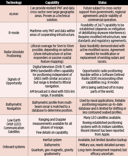
Table 1. Capability and status of complementary positioning technologies. (Chart: GLA)
The General Lighthouse Authorities of the U.K. and Ireland (GLA) reached Initial Operational Capability for eLoran on the East coast of the U.K. Although it was shown to work well technically, it has not been possible to implement the system in Europe on a regional basis.
The GLA have also been involved in the potential development of other, non-satellite based, alternative systems. These may now form the basis of positioning resiliency either individually, or as a tapestry of systems serving the maritime navigator in Europe, unless current plans for commercial operation of eLoran come to fruition.
Here we consider the technical and regulatory status of eLoran in comparison with the other options, and explore necessary steps to protect the maritime navigator in the face of increasing GNSS outages. Several alternative backup technologies could be considered complementary to GNSS for future introduction into ships’ Integrated Navigation Systems. They have varying capabilities, and different limitations and levels of maturity, summarized in Table 1. Figure 1 shows estimated timescales for development and implementation.
Figure 1. Timeline for resilient PNT. (Image: GLA)
Conclusions
■ eLoran is the only complementary backup system that can be implemented within the timescale envisaged for the introduction of e-navigation; however, there are political obstacles to implementation, at least in Europe.
■ R-mode and possibly radar positioning could be introduced by about 2030; however, both have inherent coverage limitations. Feasibility studies are needed to assess their economic viability.
■ Other options, such as inertial systems and signals of opportunity, might emerge as viable alternatives by 2030, but there are large uncertainties about technical and regulatory matters.
■ Quantum devices and options such as bathymetric and geomagnetic positioning can only be considered as longer term and uncertain possibilities.
■ A multi-system solution may offer the best approach. The IMO concept of the Integrated Navigation System aboard vessels, incorporating a multi-system receiver, provides flexibility for the inclusion of the above positioning technologies, if and when they become available, at an affordable cost.
The Loran sites at Havre, Montana; George, Washington; and Fallon, Nevada, will continuously broadcast from 0900 (MST) June 20 through 1200 (MST) on June 30. The sites will operate on the 5990 rate but occasionally may operate at other rates.
Only the site at Fallon will operate as an eLoran site. The sites at Havre and George will operate as Loran-C sites synchronized to UTC.
For further information on eLoran, tune into the free webinar on June 15, “Alternative PNT Services.” One of the four presentations will be by Steve Bartlett, executive vice president of UrsaNav, who will provide a brief overview of eLoran technology and performance characteristics with a focus on timing in critical infrastructure applications. Other presentations will cover a new Satellite Time and Location service and indoor timing with a terrestrial beacon system.
UrsaNav is engaged in a Cooperative Research And Development Agreement with the U.S. Department of Homeland Security, the U.S. Coast Guard and Harris Corporation to research, evaluate and document eLoran technology as a candidate for providing position, navigation and timing (PNT) information. eLoran is being evaluated as a potential complementary system to GPS. UrsaNav believes that there is a potentially viable market, in both the public and private domain, for an alternative PNT service that is independent of GPS signal reception or which can be used in GPS-denied environments.
Texas company Continental Electronics has patented a transmitter system and method for construction of low-frequency antenna towers significantly lower in height than previously needed for identical coverage.
“One obstacle to deploying eLoran systems has been the sheer height needed for the transmission towers, each of which requires significant acreage,” said Mike Rosso, vice president of Dallas-based Continental Electronics. “Tower height and land required not only represent serious financial costs, but in some cases adequate space is simply not available. Our technology can reduce tower height and real-estate requirements. With this, reducing antenna tower height by half would reduce required land area to one quarter.”
The method uses digital adaptive correction, solid-state amplifiers, envelope modulation and a wideband matching network. Any linear distortions within usable bandwidth are removed by digital adaptive correction, according to the company. Envelope modulation is required to achieve linearization for any signal type including Loran. A wideband matching network tunes out capacitive reactance from electrically short antennas, transforms impedance to a value suitable for the transmitter, increases usable bandwidth and suppresses harmonics and out-of-band emissions.
“We hope this will aid moving forward eLoran deployments around the world,” Rosso added. “Widely used satellite-based navigation and timing services are vulnerable to jamming, spoofing and other forms of interference. The world needs a more resilient solution as afforded by ground-based solutions such as eLoran.”
LORAD++ CORE, an alternative PNT source to combat GNSS denial: 60 x 30 x 8 millimeters
A new series of integrated eLoran/Chayka/GNSS receivers emphasize low-power requirements and small size for alternative positioning, navigation and timing (PNT) to reduce risks of GNSS denial.
Loradd++, from Netherlands-based firm Reelektronika, consists of a receiver board of 60 x 30 x 8 millimeters, consuming less than 500 milliwatts (3.3 volts) in continuous operation. The Loradd++ can be used with either E-field or H-field antennas, features dual serial interface for integrated systems, and is connectable to certain miniature GNSS receiver modules.
eLoran and Chayka are recognized as alternative PNT systems, but current receivers on the market are large in comparison to miniature GNSS devices. Chayka is a Russian terrestrial radio navigation system, similar to Loran-C. It operates on similar frequencies around 100 kHz, and uses the same techniques of comparing both the envelope and the signal phase to accurately determine location.
The first of a new series of receivers is Reelelektronika’s Loradd++/E, which is an integration of the Loradd++ with an E-field antenna housed in a small single radome that can be connected via a data cable (up to 150 meters) and a dongle to a USB port on a PC. The radome contains a u-blox M8T GNSS receiver with antenna and measures 135 millimeters in height and 85 millimeters in diameter. The Loradd++/E needs less than 700 milliwatts at 4-16 volts.
Reelektronika manufactures eLoran equipment for users, service providers and surveyors. The company developed the eDLoran system. eDLoran works with existing Loran transmitter stations and yields differential Loran position and navigation accuracies comparable to GPS; see the cover story of the July 2014 issue of GPS World. The system can thus be considered as a robust backup for GPS.
The Wildwood transmitter is back on the air after a presumed lightning strike affected transmissions.
The transmitter stopped broadcasting at 5:35 a.m. EST on Feb. 9. Testing took place 5:35 a.m. to 8:19 EST, after which it came back on the air, reports Steve Bartlett, vice president of operations for UrsaNav Inc.
The transmitter will be taken off the air tomorrow morning (Feb. 10) so that engineers can assess and repair any damage.
The Wildwood, New Jersey, eLoran transmitter will be continuously broadcasting from 9 a.m. EST on Feb. 6 through 12 p.m. EST on March 31, announced Steve Bartlett, vice president of operations for UrsaNav Inc.
“Wildwood will be broadcasting as 8970 Master and Secondary most of the time, but occasionally may operate at other rates,” Barlett said.
The Loran Data Channel (LDC) will be undergoing testing and may be unavailable or unreliable for short periods of time Feb. 6-10, he said.
The United States Federal Aviation Administration (FAA) has released its Performance-Based Navigation (PBN) National Airspace System (NAS) Navigation Strategy 2016, the result of a concerted year-long effort by FAA and aviation industry stakeholders. It describes how the FAA intends to transition U.S. NAS operations over the near- (2016–2020), mid- (2021–2025) and far-term (2025–2030) from predominantly point-to-point navigation, reliant on hundreds of ground-based navigation aids, to PBN-centric operations relying on systems and services supporting Area Navigation (RNAV) and Required Navigation Performance (RNP).
Performance-based navigation specifies the aircraft area navigation performance in terms of accuracy, integrity, availability, continuity and functionality needed to conduct specific operations in a particular airspace.
While promoting the PBN benefits of GNSS such as the GPS and the Wide Area Augmentation System (WAAS), the PBN Strategy also recognizes the need to maintain resilient PBN capabilities that remain unaffected in the event of GNSS interference, and that can continue to support PBN operations or provide safe navigation alternatives. It is a well-constructed, valuable document that provides detail on the means by which many of the Operational Improvements (OIs) described in the FAA’s Next Generation Air Transportation System (NextGen) implementation Plan (NGIP) will be achieved.
The FAA began the introduction of PBN operations following the release of its Roadmap for Performance-Based Navigation in 2003, which promoted more efficient and higher capacity operations based on the capabilities of modern aircraft and emerging GNSS-supported PBN procedures. By 2010, many PBN procedures were in use across the NAS, and especially at the busiest airports and most complicated and congested airspace. Building on this experience, the 2016 PBN Strategy recognizes that the U.S. NAS is not a homogeneous entity; its needs vary based on both location and time. To best serve NAS users and to continue to provide the safest, highest capacity, most efficient airspace in the world, some of the key concepts of the strategy are to provide:
the right procedure to meet the need;
structure where beneficial and flexibility where possible;
shifting to time- and speed-based air traffic management;
and delivering and using resilient navigation services.
To provide correct procedure and structure where needed, the PBN Strategy defines six Navigation Service Groups (NSG) and services potentially available at the airports within each group. NSG 1, now comprising about 15 airports, is reserved for the busiest large hubs that would benefit from common aircraft performance capabilities to maximize capacity. NSG 2 contains the remaining large-hub and all medium-hub airports. Small and non-hub airports comprise NSG 3. NSG 4 includes more than 500 airports, including national and regional general aviation (GA, or private plane) airports, and NSG 5 2,400 local and basic GA airports. NSG 6 consists of thousands of small airports not part of the National Plan of Integrated Airport System (NPIAS).
Time- and speed-based navigation is essential to optimal utilization of airport capability and capacity for both arrival and approach and departure operations. The ability of aircraft to more precisely follow PBN procedures because of onboard navigation capability and space- and ground-based navigation services maintains safety, increases airspace and runway utilization, and — because of more efficient, precise routing — minimizes fuel burn and carbon footprint.
The PBN Strategy also recognizes the need to maintain resilient PBN services and, while GNSS-provided PNT services are able to support both RNAV and RNP procedures, GNSS is vulnerable to both intentional and unintentional interference. To preclude loss of efficiency and capacity benefits in the event of GNSS interference, the FAA will maintain and improve the ground-based Distance Measuring Equipment (DME)/Tactical Navigation (TACAN) network to support DME-DME RNAV 2 in the enroute domain and RNAV 1 in the necessary terminal domains. Because of plans to fill gaps in coverage at high altitudes (FL 180 and above) and remove single DME facility criticality, aircraft without inertial reference units (IRUs) will be able to fly these procedures using DME-DME RNAV, although at the much lower altitudes associated with terminal operations, an IRU may still be required. For aircraft without DME-DME RNAV capability, for example General Aviation, the FAA will maintain a Minimum Operational Network (MON) of Very High Frequency Omnidirectional Ranges (VORs) to either support navigation out of a GNSS interference area or navigation to an airport where approach and landing is supported by either an Instrument Landing System (ILS) or VOR.
Commentary
PBN services depicted across Navigation Service Group airports represent the standard in the far term, 2026–2030.
The FAA’s plan to maintain resilience, while admirable, does have some issues. All of the VORs, DMEs and TACANs that provide resilient navigation services are extremely old, the vast majority designed in the 1970s and installed in the 1980s. There is no current plan to modernize or recapitalize them.
As for researching and developing an Alternate Position, Navigation and Timing capability that would support resilient PBN capability for all of aviation, maintain the ability for aircraft to report their positions via Automatic Dependent Surveillance – Broadcast (ADS-B), and support the rapid and vast emergence of unmanned aerial vehicles (UAS) and benefits, the PBN Strategy states that “During the far term and moving out into the 2030 timeframe and beyond, the FAA will continue to research the best methods for Alternate Position, Navigation and Timing (APNT).”
This delay is unfortunate, as further delay in implementing PNT resilience for all aspects of aviation, as well as for all critical infrastructure areas is, at best, imprudent, as recent agency attempts to develop and implement other resilient PNT capabilities — Enhanced DME (eDME) and Enhance Loran (eLoran) — have been suspended.
The release of the 2016 PBN Strategy is a significant event. It will help guide the agency and the aviation community forward. It will help clarify policy, facilitate decisions, drive equipage, and provide for a safe, higher capacity and more efficient NAS. It is a good start, which could be improved by recognizing the significant investments needed in resilient PNT equipment, architecture and systems.
The Advanced Autonomous Waterborne Applications Initiative (AAWA) published a white paper in June as part of presentations at the Autonomous Ship Technology Symposium 2016 in Amsterdam. The white paper outlines the Project’s vision of how remote and autonomous shipping will become a reality.
Oskar Levander, Rolls-Royce vice president of Innovation – Marine, said, “This is happening. It’s not if, it’s when. The technologies needed to make remote and autonomous ships a reality exist. The AAWA project is testing sensor arrays in a range of operating and climatic conditions in Finland and has created a simulated autonomous ship control system which allows the behaviour of the complete communication system to be explored. We will see a remote controlled ship in commercial use by the end of the decade.”
The AAWA white paper explores the research carried out to date on the business case for autonomous applications, the safety and security implications of designing and operating remotely operated ships, the legal and regulatory dimensions and the existence and readiness of a supplier network to deliver commercially applicable products in the short to medium term.
Positioning Technologies. The proposed system draws on a range of sensors (see Figure 1) including GPS, inertial, lidar, cameras, short-range radars, and electronic charts. “When combined witha global or local positioning reference such as GNSS, and with wind sensors and inertial measurement units, the ship is able to keep its position even in rough weather conditions,” states the report. “The main question is therefore not whether the implementation of autonomous ship navigation is technically possible, but what is the combination of technologies and methods that provides the level of performance and reliability that is required for practical operation of large vessels, and at a reasonable cost.”
The white paper draws on a wide range of expertise from academic researchers at some of Finland’s leading universities. Industry input has been provided by leading members of the maritime cluster including Rolls-Royce, Brighthouse NAPA, Deltamarin, DNV GL and Inmarsat.
The project also has the support of shipowners and operators. The tests of sensor arrays are being carried out aboard Finferries 65-metrer double ended ferry, the Stella, which operates between Korpo and Houtskär. ESL Shipping Ltd is helping explore the implications of remote and autonomous ships for the short sea cargo sector.
Iran Reiterates Loran Effort
Researchers at Iran’s Malek-Ashtar University have developed a 1-megawatt transmitter with half-cycle technology for a national project announced as a replacement for GPS, which is currently employed for all positioning, navigation and timing services across the country. Given the lack of control on the GPS’s accuracy and quality and a possible outage of the system in critical conditions, the country’s defense ministry has set out to develop a local positioning system (LPS) for positioning and timing.
Experts at the U.S.-based Resilient PNT Foundation say the description of the system make it appear to be a variant of Loran, probably similar to those operated in Russia and China. If it is such a Loran variant and if it complies with international standards, it should complement Saudi Arabia’s Loran signals in the Persian Gulf, they said.
Iran will establish five stations with powerful transmitters in appropriate locations to provide navigation, positioning and timing services in compliance with international standards, according to the country’s defense minister.
Iran made a similar announcement about a land-based navigation system in December 2013. The country’s military experts and technicians have reportedly logged significant progress in manufacturing a broad range of indigenous equipment.
U.S. eLoran August demonstration
The Wildwood, New Jersey, eLoran transmitter will continuously broadcast from July 29 through 12 p.m. Eastern time on Aug.15. Wildwood will broadcast as 8970 Master and Secondary most of the time but occasionally may operate at other rates.