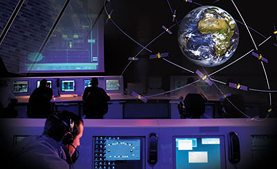
The European Union Agency for the Space Programme (EUSPA) and Naviair — a company that specializes in air navigation and related infrastructure services and is owned by the Danish state and represented by the Ministry of Transport — have partnered to strengthen the monitoring capabilities of the Galileo search and rescue (SAR) service by adding a new site in Greenland.
The partnership between EUSPA and Naviair will expand the ground segment and current SAR capabilities. As part of the agreement, Naviair will contribute to the Galileo Programme objectives by procuring, deploying, hosting, and operating a reference beacon (REFBE) near the Kangerlussuaq Airport in Greenland.
The new SAR/Galileo site and REFBE will be located around the margins of the declared service coverage area and will be fully integrated into the SAR ground segment, bringing the number of REFBEs to eight. The REFBEs provide data for service performance monitoring.
There are currently five REFBEs in the European coverage area and two in the Indian Ocean coverage area.
The REFBEs are fitted with vertical linear polarized antennas that transmit timely, synchronized signals equivalent to a standard 406 MHz Cospas-Sarsat beacon. This, combined with their well-known position, enables specific SAR/Galileo Service performance indicators to be derived.
The new site will be ready by the fourth quarter of 2023.
The SAR/Galileo component of the EU Space Programme plays a crucial role in the detection of emergency signals transmitted by distress beacons in support of the internationally recognized SAR Cospas-Sarsat program. As part of this program, the Galileo SAR Service utilizes SAR instruments onboard Galileo satellites, medium-Earth orbit local user terminals, and a network of SAR REFBEs located across Europe.
Europe’s 2nd Horizon Europe call has been launched for European GNSS, Galileo and Earth observation projects, offering total funding of €48.1 million.
The Horizon program is managed by the European Union Agency for the Space Programme (EUSPA). It funds research and innovation by small and mid-size enterprises, academia, public actors and others that will stimulate development of space applications and solutions using EUSPA data and services.
The 2nd call aims to to strengthen downstream capabilities and modernize the EU public sector by offering cutting-edge solutions based on Galileo, Copernicus, EGNOS and GOVSATCOM.
Funding is being offered for projects that make use of Galileo and EGNOS in smart mobility applications. Other projects fuse Copernicus data with artificial intelligence to boost the European economy and help modernize the public sector. For the first time, the call seeks to deliver satellite communication use cases based on the forthcoming GOVSATCOM system.
Below is a breakdown of the funds’ distribution per thematic area.
Visit the EU’s funding & tender opportunities portal for detailed information about the EUSPA call and the topics available. The deadline for applications is March 2, 2023.
A new space agency launched in Europe today, taking the place of the European GNSS Agency (GSA) and adding responsibilities to encourage Europe’s space enterprises.
The European Union Agency for the Space Program (EUSPA) marks the start of a new era for European Union space, according to an agency statement. EUSPA will build on the legacy of the GSA, which was established to promote use of Galileo and EGNOS, with additional responsibilities to create even more opportunities from space for European Union citizens and its economy.
An April 27 space regulation established EUSPA. Under the new space regulation, EUSPA’s mandate includes promoting Galileo and EGNOS, but with increased responsibilities, including their service provision and operational security. The agency also will coordinate the user-related aspects of government satellite communication in close collaboration with Member States and other entities.
Including Copernicus
Rodrigo da Costa, executive director, EUSPA (Photo: EUSPA)
EUSPA is also responsible for the development of downstream markets and fostering of innovation based on Galileo, EGNOS, and now also commercial uses of Copernicus (Europe’s Earth observation satellite program), leveraging funding mechanisms such as Fundamental Elements and Horizon Europe.
EUSPA is also responsible for security accreditation of all the components of the EU Space Program. The European Commission may also decide to entrust the agency with other tasks.
“More and more, our economies, our society and our safety depend on space,” said EUSPA Executive Director Rodrigo da Costa, former director of GSA. “Europe has incredible opportunities ahead that cannot be missed. By creating EUSPA, the European Union will further increase the return on investment made by EU citizens in the EU Space Program by strengthening its contribution to the priorities of the union. We will achieve this primarily by leveraging synergies between the various program components — particularly navigation, Earth observation and secure communications — to drive innovation across a broad range of sectors.”
In particular, bringing management of downstream and combined applications based on Galileo, EGNOS and Copernicus under the umbrella of one agency will make it possible to leverage synergies, according to the agency statement. “On their own, these technologies can play a key role supporting a digital and green transformation, but leveraging their synergetic and combined use will facilitate the generation of innovative solutions that bring a higher societal impact,” the statement read.
Focus on security
“The teams of committed professionals we have in place at our sites in Europe — from the EGNOS center in Toulouse to the European GNSS Service Centre in Spain and the Galileo Reference Centre in the Netherlands — will continue to ensure the high quality, robustness and reliability of EUSPA’s service provision,” reads the statement. “This will be backed up Galileo security monitoring centers in France and in Spain, and the industrial teams managed by EUSPA in the Galileo control centers in Germany and Italy, along with facilities around the world.”
In addition, the Security Accreditation Board will continue to initiate and monitor implementation of security requirements to ensure a robust and uniform level of security for the entire EU Space Program.
“The new agency has a core role in the security accreditation of all the components of the EU Space Program,” said Bruno Vermeire, chair of EUSPA’s Security Accreditation Board.
Looking to the future
While EUSPA’s mission has expanded, its core aim remains the same – to link EU investment in space to the needs of users in the European Union and around the world.
“The agency remains committed to its traditional users and will continue to deliver the high level of GNSS services that users have come to rely on,” the agency stated. Copernicus and satellite communications will also benefit from the former GSA’s user-oriented focus and “the experience it has gained in developing markets for Galileo and EGNOS.”
Fucino, Italy, hosts a Galileo Control Centre. (Image: Telespazio/ESA)
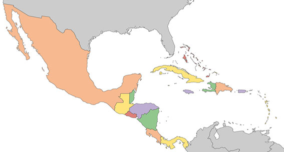
A new Galileo Information Center for Mexico, Central America and the Caribbean has opened in Mexico City, with training facilities in Querétaro, Mexico. The 177-million population is a largely untapped market for space, according to Telespazio Ibérica.
Telespazio Ibérica will run the center as leader of a consortium composed of European and local industrial and institutional partners such as everis, Enaire, Geotecnologías, and universities including the Universidad Politécnica de Madrid and the Universidad Nacional Autónoma de México.
The center is co-financed by the Directorate-General for Defence Industry and Space (DG DEFIS) of the European Commission for 36 months. Its goal is to enlarge the ecosystem of Galileo Information Centers as it joins two existing centers in Chile and Brazil, active since November 2019. The centers contribute to the European Commission’s outreach to promote the EU Space Programme and foster its market uptake in Latin America.
The new center will help improve visibility of European satellite navigation and promote cooperation on Galileo and EGNOS between the EU space ecosystem and regional stakeholders. This includes building valuable insights on local GNSS markets, monitoring local and regional satellite navigation initiatives, and seeking to understand regional needs and the market potential for European GNSS. The center will provide communication, promotion and training activities.
“Telespazio Ibérica already plays a key role in the Galileo Service Center in Madrid,” said Miguel Bermudo, CEO of Telespazio Ibérica. In Madrid, the company operates on behalf of Spaceopal, a joint venture between Telespazio and the German Space Agency DLR, under the GSA contract for the Galileo Service Operator.
“We have chosen to co-finance this project with DG DEFIS to promote Galileo in Mexico, Central America and the Caribbean,” Bermudo said, “considering its presence in this important region to be of a great strategic value both in promoting the use and applications offered by Galileo and the opportunity it represents for Telespazio Group.”
On Oct. 16, Rodrigo da Costa took up his duties as executive director of the European GNSS Agency (GSA), soon to become the EU Space Programme Agency.
He was elected by the GSA Administrative Board on Sept. 15 and met with the ITRE Committee of the European Parliament on Oct. 12.
Da Costa, a Portuguese national who has worked in a number of EU countries, joined the GSA as the Galileo Services Programme manager in March 2017. In this position he was responsible for leading Galileo, the European Union GNSS, in its service provision phase.
He has previously held several senior project management, business development, and institutional account management positions in space industry, in the areas of human space flight, exploration, launchers and research and development.
Da Costa will now be working on transforming the GSA into the EU Space Programme Agency (EUSPA). He will ensure that its existing activities continue to be successfully delivered while also performing new ones required to undertake with the Agency’s new mandate.
Since its creation in 2004, the GSA has made an unparalleled contribution to the EU flagship satellite systems Galileo and EGNOS, which have significantly contributed to the union’s independence and economic growth.
Staffed with highly skilled and dedicated personnel, the agency has boosted innovation, fostered entrepreneurship, led the provision of services, and stimulated the EU economy, in particular through ensuring Galileo and EGNOS uptake across a wide range of market segments thanks to high-quality and secure satellite services.
Rodrigo da Costa, executive director of the European GNSS Agency. (Photo: GSA)
With eyes fixed on the future, EUSPA will further build on the work of the GSA, and will take on additional new responsibilities for further components to the EU Space Programme, including activities in Copernicus (the European Earth observation programme), GOVSATCOM (the EU secure satellite communication system).
Commenting on his new duties da Costa said: “Becoming Executive Director of the Agency means, above all, to lead a team of excellent, dedicated professionals. I’m immensely excited by the opportunity we have to build a successful EUSPA, a key contributor of the EU Space Programme. I’m looking forward to working with all our stakeholders. The task is vast, but I am confident we will be able to play our part, demonstrating to EU citizens what we can do together in EU space activities as GSA/EUSPA.’’
The European GNSS Agency (GSA), in collaboration with the Council of European Geodetic Surveyors (CLGE), has launched the Geomatics on the Move 2020 competition. The event aims to foster the use of European Union (EU) satellite programs Galileo, EGNOS and Copernicus among students, young professionals, entrepreneurs and small and mid-sized businesses to create innovative geomatics applications and solutions across all over Europe.
Building and expanding on the CLGE Student Contest, which has been held for the past nine years, the new Geomatics on the Move Prize Contest targets applications that integrate the use of additional technologies such as artificial intelligence, machine learning, augmented and virtual reality, as well as supplementary remote sensing data sources like drones, GSA said. Solutions animated through mobile phone applications or other easy-to-use platforms are also accepted.
“This is the ninth year of partnership between the Council of European Geodetic Surveyors and the GSA; over the years we have seen some exciting and innovative solutions emerge that leverage the EU Space Programme to deliver practical solutions for the mapping and surveying community,” said GSA Acting Executive Director Pascal Claudel. “This year, as we recover from this global setback, I look forward to seeing even more novel ideas — from all over the European Union — able to respond to current and future challenges.”
The competition will be organized in two stages. The first phase is an open call for ideas, during which applicants submit posters describing their ideas. The deadline for these submissions is Oct. 16.
The proposals then will be evaluated by the GSA and CLGE, and a maximum of 10 projects will be chosen to present their pitch during the finals. The selected applicants will refine their poster and prepare their pitch, for which technical support and training will be made available.
The official award of the Geomatics on the Move prize contest will take place virtually, during the European Space Week, taking place Dec. 7-11. During this event, finalists will present their solutions to the evaluation board, and winners will be announced on the official contest site.
With an overall prize of €30 000, a set of 10 prizes will be offered in two categories. The first of these categories targets EU space-based traditional geomatics solutions and the second targets integrated geomatics solutions. he first category is looking for solutions in which the main innovation is based on the use of EGNSS, employing traditional equipment such as surveying or GIS grade GNSS receivers for applications such as cadastral, marine and mining surveying or GIS mapping. The integrated geomatics category targets integrated surveying solutions that use Galileo or EGNOS and leverage cutting-edge tools and technologies such as drones, mobile mapping, laser scanners or augmented/,mixed reality, both within geomatics applications or beyond.