Lori Thompson with Exelis Inc. gives updates about the company at the 2014 ION GNSS+ Conference September 9-12 in Tampa, Florida. The company is celebrating more than 700 years of on-orbit performance.
Tag: Exelis
-
GPS III Payload Arrives, Platform Acceptance Tests Next
Enter GPS III. The long-awaited navigation payload for the next-generation satellite pulled into its new temporary home over the September 13 weekend, the Lockheed Martin Space Systems facility in Littleton, Colorado. Lockheed is the U.S. Air Force’s prime contractor for the first batch of eight GPS III satellites.
Exelis Geospatial Systems has committed to delivering the payloads for the second, third, and fourth GPS III satellites “right on the heels” of the first, according to Gen. John Hyten, commander of Air Force Space Command. “If that’s the case, in the not-too-distant future GPS III will be in good shape,” he added. The first GPS III launch is now scheduled for 2016.
Exelis has built GPS payloads since the beginning of the program, but found new challenges over the last two years posed by advanced features of the modernized version. “First-time development and integration issues, including design changes to eliminate signal crosstalk” have set back the schedule.
According to reports, Lockheed Martin has a group of initial platforms readied on its production line to take the incoming payloads.
Still ahead, completion of acceptance testing following integration with the first satellite platform.
Earlier this year, Lockheed Martin issued a request for information on alternate payload providers, and received responses from five companies. In June, the Air Force issued a call for contractors interested in building the next batch of GPS IIIs. Northrop Grumman and Boeing have responded.
-
Exelis GPS Threat Detection Offers Improved Capabilities
The Signal Sentry 1000. Based on customer use and feedback, Exelis has improved its Signal Sentry 1000 product to include enhanced, user-friendly analytics and alerts. Signal Sentry technology detects and locates sources of intentional and unintentional interference to GPS signals and provides users with actionable intelligence.
Exelis is showcasing Signal Sentry 1000 in Booth 619/621 at the ION GNSS+ conference September 10-12 in Tampa, Florida.
Enriched features of Signal Sentry 1000 include superior sensors that increase detection accuracy to better pinpoint the jamming source, enhanced analytics to recognize patterns of jamming, and easy-to-use history functionality to comprehend where interference happened and to follow its path. Instant reporting of jamming events via text or email so that appropriate resources may be deployed to an incident is also a new feature of Signal Sentry.
“Signal Sentry was developed by Exelis to protect critical infrastructure and to deliver intelligence to police agencies. Since Signal Sentry has been used by law enforcement, we have been able to enhance the products investigative and intelligent-led policing capabilities,” said Carl Slutsky, product line manager for Signal Sentry at Exelis. “Now, users can see patterns such as what happened and when and where it happened to better allocate their investigative resources. Additionally, we added an alert feature to Signal Sentry that provides real-time notice of a GPS jamming event, so law enforcement can dispatch a patrol unit to the precise location of the jamming event.”
Because of the broad availability of low-cost GPS jamming devices on the Internet, the risk associated with signal disruption has increased significantly. GPS jammers are often used by criminals to conceal stolen cars and by commercial drivers whose intent is merely to hide their location from their employer. Truckers who used personal-privacy GPS jammers near shipping ports have caused interference with the signal also used to navigate large ships, which severely compromised safety and the efficient operation of the port.
Signal Sentry leverages GNSS signal domain knowledge and is based upon patented technology developed through the company’s history of designing and fielding electronic intelligence systems. Exelis navigation payloads and components have been on board every U.S. GPS satellite ever launched and have more than 700 years of accumulated on-orbit success.
-
DigitalGlobe Launches WorldView-3 High-Resolution Commercial Satellite
DigitalGlobe, a provider of commercial high-resolution Earth observation and advanced geospatial solutions, successfully launched WorldView-3, the company’s sixth and most advanced super-spectral, high-resolution commercial satellite.
The satellite launched August 13 on a Lockheed Martin Atlas V rocket from Vandenberg Air Force Base in California.
“The successful launch of WorldView-3 extends DigitalGlobe’s commanding technological lead and will enable us to help our customers see through smoke, peer beneath the ocean’s surface, and determine the mineral and moisture content of the Earth below — all with unprecedented clarity,” said Jeffrey R. Tarr, chief executive officer of DigitalGlobe.
WorldView-3 will collect super-spectral imagery at 0.31 meter resolution — delivering five times the clarity of the company’s nearest competitor. In addition, WorldView-3 will offer the most spectral diversity available commercially, the company said, and will offer multiple shortwave infrared (SWIR) bands that allow for accurate imaging through haze, fog, dust, smoke and other air-born particulates. The satellite will also offer CAVIS — a cloud, aerosol, water vapor, ice and snow atmospheric correction instrument — which monitors the atmosphere and corrects data for an unprecedented level of consistency.
“The unmatched abilities that WorldView-3 brings to our constellation will enable us to provide our customers with information and insight never before possible and advance our efforts to create a living digital inventory of the Earth,” Tarr said.
The satellite and atmospheric monitoring instrument called CAVIS were built by Ball Aerospace. Exelis built the integrated, super-spectral payload consisting of a telescope, sensor and shortwave infrared system, making WorldView-3 the first commercial satellite to carry such capabilities. A United Launch Alliance Atlas V launch vehicle provided by Lockheed Martin Commercial Launch Services (LMCLS) delivered the satellite into orbit.
-
Scene Sharp Unveils Fuze Go Plugin for ENVI at Esri User Conference
Scene Sharp USA has introduced its Fuze Go Plugin for ENVI this week at the Esri User Conference in San Diego. The plugin gives ENVI software users access to Fuze Go MS Sharp, an automated multispectral image fusion software that can simultaneously fuse up to 30 spectral bands of data from inside the ENVI geospatial processing package.
“The Exelis ENVI software is widely known for its multi- and hyperspectral image processing capabilities and is an ideal platform for geospatial information users to access the automated Fuze Go MS Sharp image fusion software,” said Ian Lucas, President and CEO of Scene Sharp Technologies Incorporated.
Scene Sharp is demonstrating the Fuze Go plugin along with the full line of Fuze Go software products in booth #410 at the Esri User Conference being held July 14-18 in San Diego.
The plugin gives users the option of accessing the Fuze Go MS Sharp software either within the ENVI workflow or outside of it so that fusion can be performed as a stand-alone application. This frees up the ENVI software license for other image processing activities. No GIS or image processing experience is needed to utilize the Fuze Go tools.
Fuze Go is a fully automated technology that enables users to quickly and easily fuse data sets to add color to non-colorized satellite and aerial imagery with just a few mouse clicks. One of its most common applications is pan-sharpening. By colorizing image data, GIS users can visualize and extract richer information content from remotely sensed data to make better informed decisions.
Also at the 2014 Esri UC, Scene Sharp USA is demonstrating the processing capabilities in its Fuze Go SAR Sharp application, which was designed for more effective exploitation of data captured by satellite-based synthetic aperture radar (SAR) sensors. Fuze Go SAR Sharp fuses gray-scale radar data with optical multispectral bands to colorize the SAR data set. The Dynamic Reader allows pre-process on-the-fly viewing of SAR imagery with real-time adjustment of color intensity being added to the scene.
Fuze Go MS Sharp and SAR Sharp are available for purchase for an annual license fee. Batch processing versions of the software packages are also offered to perform automatic fusion of multiple optical or SAR scenes.
-
Boeing, Northrop Grumman Enter GPS III Bid
Northrop Grumman and Boeing have responded to a U.S. Air Force call for contractors interested in building a follow-on set of GPS III satellites, according to a report in Space News.
Lockheed Martin is under contract to deliver the first eight GPS III satellites, but the award for up to 22 further IIIs remains open. Difficulties with the payload for the first batch of satellites mean that although the Lockheed has three space vehicles ready, it has no signal payload to put aboard them. Subcontractor Exelis is at work on that. Delivery delays have prompted the Air Force to look about for alternatives.
Lockheed Martin itself began investigating options for its supply line last year.
Air Force “Sources Sought” Call
The U.S. Air Force issued an official “Sources sought” notice in June on a production-ready GPS space vehicle, equipped with an alternate payload, for consideration alongside the Lockheed Martin-built GPS III vehicle. The first phase of the contract would include two firm-fixed price contracts worth $100–$200 million to demonstrate a competitor to GPS III.
Key requirements are that the satellite must offer a payload alternative to that built by Exelis; the satellite must be ready to launch by 2023; and the production line must turn out two to three new satellites per year.
The second phase features a competition between Lockheed Martin and one or more other companies for as many as 22 satellites. A final contract award would be made in 2017 or 2018.
Current GPS III contractor Lockheed Martin reportedly sent an engineering team to help Exelis expedite a resolution of payload holdups, while simultaneously investigating a switch to other suppliers, beginning with the ninth satellite in the GPS 3 series. Lockheed Martin says five companies responded to its solicitation last year.
Air Force Gives Free Hand. Gen. Ellen Pawlikowski, head of the Air Force Space and Missile Systems Center (SMC), told the national Space Symposium in Colorado in June, “Obviously we want a GPS III that does what its supposed to do, delivered on time, and it’s up to Lockheed to manage its subcontractors. My view is if Lockheed is not happy with their subcontractors nav payload, and they believe that they can get a lower risk approach to delivering a nav payload by seeking a secondary source for that, then that’s clearly a decision for them to make.
“They [Lockheed ] know we are disappointed at the delays that we have seen, the technical issues that their subcontractor has had, and probably they are considering whether an alternative source could provide them a better opportunity.“
Lockheed Martin spokesman Chip Eschenfelder issued a statement: “Exelis has made good progress on the first GPS III space vehicle, SV01 navigation payload. All GPS III SV01 navigation payload components have successfully completed unit acceptance and environmental testing, with the exception of one component, the mission data unit.
“To date, significant MDU hardware testing indicates signal cross talk issues are resolved. The SV01 navigation payload forecast delivery to Lockheed Martin is fall 2014.”
Boeing built the platform and major payload components for the GPS IIF satellites and is one of three companies that received contracts in January 2013 to study how to improve the accuracy, coverage, and efficiency of GPS using smaller satellites.
Northrop Grumman Aerospace of Redondo Beach, California, has already delivered deployable antenna sets to Lockheed Martin for the first six GPS III satellites. The division has delivered more than 1,000 antennas for previous generations of GPS spacecraft, Northrop Grumman said.
-
Lockheed Misses GPS III Deadline After Production Delays
The U.S. Air Force is shopping for alternative companies to head the GPS III program after its current contractor, Lockheed Martin Space Systems, hit production delays, according to the Denver Post.
There have been technical problems with the first GPS III satellite navigation system, which is supplied by Lockheed Martin subcontractor Exelis, the newspaper reports.
After the current eight-satellite contract is fulfilled, contracts to build the 22 remaining spacecraft are up for bid, according to a notice posted by the Air Force on the Federal Business Opportunities website.
Exelis’ navigation system was producing signal interference that prevented Lockheed from delivering by its target date earlier this year, which is now anticipated for delivery in 2015. The system is undergoing rigorous tests.
-
The Adventure of the Atomic Clock
In consulting my notebooks for the spring of 2014, I find many remarkable cases that engaged the attention of my intimate friend Mr. Sherlock Holmes. Among them stand out the tragedy of the ancient British barrow, the disappearance of Pemblestoke the magician, and the curious facts associated with the giant rat of Sumatra, a tale for which the world is still not prepared. Perhaps none of these so well illustrate, however, the advanced technical insights and consultative powers of the great detective as did the intrigue into which we were drawn by the brilliant young American scientist, Geo. P. Hess.
“Watson, we have a new client,” Holmes announced over breakfast, “a friend, actually, upon whom I have depended for many years. He has always proved reliable, helping me navigate the highways and by-ways all across the land.”
“His name?” I inquired.
“The Right Honorable George Parkinson Hess from California, Colorado, Pennsylvania, Florida, and doubtless many other parts of the American nation. I have watched G.P. Hess grow these last 36 years into a prodigiously successful entrepreneur, known the world round for his ubiquity, openhanded generosity to all, and, equally, his devotion to his own country. Now it seems he needs my advice, and I cannot refuse him.“
“I wonder that an American should be able to find his way here this morning,” I replied. “There’s a beastly fog about, and London streets are no friendly environment under the best of conditions.”
“Have no fear, Watson,” Holmes chuckled. “I have never known G. P. Hess to be late for any function. Since a lad he was always on time, right to the second. You can set your watch by him, and as far as I know he has never been lost. He has an uncanny sense of direction and is indeed a fount of knowledge concerning maps and directions. I believe I hear his ring at the bell even now.”
Mrs. Hudson ushered in our American visitor, and Holmes introduced us. “It is always good to see you, G.P. How are you — in good health, I presume?”
“Indeed, Mr. Holmes, things are neither as well they may seem on the surface, nor as well as they could be. I am troubled of late, severely troubled by potential gaps in my future. Not to mention the seismic activity lately in Los Angeles. In the last 18 months, the magnitude of the tremors has grown from 3.1 to 5.1 on the Richter scale. I just can’t understand why they thought to have our major acquisition headquarters in a place that is constantly threatened by tremors, outright quakes, wild fires, floods, landslides, and tsunamis. Not to mention the traffic. It would have been much better to co-locate acquisition with the main headquarters in Colorado. All they have to worry about there are blizzards, high winds, and an occasional wildfire.
“While I could not agree with you more, G.P., I fail to see what I can do, try as I might, about Mother Nature.”
Fire in Florida
“Right you are, Mr. Holmes. I’ll get to the heart of the matter. I am deeply concerned about several of our business ventures: expansion and modernization efforts, if you will. You may have heard about a small but rather serious fire at the U.S. Air Force’s Cape Canaveral radar tracking facility and the subsequent launch delays. That small fire at a single tracking facility has already delayed a National Reconnaissance Office (NRO) launch, and a resupply mission to the International Space Station, currently manned by U.S. and Russian crews who, whether or not they are still speaking to one another, really need the replenishments. Now we aren’t allowed use Russian engine cores for space launch any more. A blessing, actually, as the Russians have put more malfunctioning GLONASS satellites into salt water lately than into the vacuum of space, when they aren’t simply blasting them to kingdom come.
“With all the troubles besetting Cape Canaveral, Elon Musk is burning figure eights in his Tesla, and SpaceX is a very happy company — in the right place at the right time, what? Able to launch its Falcons and Falcon Heavies from Vandenberg as well as Canaveral.
“Imagine, one little fire has caused the cancellation of several space launches, and those still on the manifest are moving to the right daily. We had hoped to put into orbit four new IIF models this year, but that looks next to impossible now. Plus it appears the GPS III payload has hit a snag. It is delayed six to nine months.”
GPS III Delay
“A delay in GPS III had not been looked for, had it?” queried Holmes.
“No sir, it had not. Everything was proceeding smoothly, but now the satellite payload is in question. Subcontractor Exelis has provided every GPS payload since 1978 and all have worked marvelously well, some of them for more than 23 years. But now — there is a problem. Some say it is signal crosstalk, some say it is with the new rubidium clocks. One thing for sure, it is demoralizing. I am given to understand the powers that be in Colorado Springs and Los Angeles are calmly but firmly looking for some competition or even an alternate payload provider.
OCX Delay
“And then there is the GPS ground segment. It has moved one month to the right for every month it has been in existence, it has gone over budget, and now is on its third program manager in three years. Whatever happened to the days when a capable leader conducted a program from beginning to end, knew it intimately from top to bottom, from soup to nuts? What is this world coming to? Where are our leaders?
“And don’t get me started on the effects of ‘seques-castration’!” fumed the young man.
“And the Chinese!” he continued, gathering steam. “Just who do they think they are? Do you know they called their regional system a PNT gold standard? Gold standard! Don’t make me laugh!”
“Now G.P., don’t despair,” soothed Holmes. “There are still excellent leaders out there, you just have to look a bit harder nowadays. In the space arena, Elon Musk, General William Shelton, Wild Bill Cooley, Frank Kendall, and Keoki Jackson are just five of many that come immediately to mind. Of course I would not want to play poker with any of them, but I digress.”
Solutions Appear
“I have been reading and thinking about the alternative payload issue,” the detective continued, “and I have other sources of information as well. Dr. Watson calls them my Baker Street Irregulars, and they are both resourceful and quite knowledgeable. These sources tell me there is another Colorado company, with excellent leadership, that is really on the ball, can move mountains (or huge boulders, anyway), and mark my words, they have top-notch crews, expertise, and even some past performance where an alternative GPS payload is concerned. They might be worth watching.
“As far as OCX goes, frankly I am hearing there are indeed backups and alternatives. My sources have confirmed the existence of a bracket of applicable technologies belonging to a small residual company, run by an Irish clan, believe it or not, with considerable past performance and expertise. Once officially launched to work on the real-time issues, they should be able to help the ground-segment team get back on the fast track.
“As for as the Chinese and their claims, all I can say is no one believes their gold standard rhetoric, although it obviously has a purpose.”
“Mr. Holmes, I hope you are right,” the American replied with an assuaged look. “I knew that if I talked with you I would feel better about these perplexing issues.
“I must resume my journey to Rotterdam, where I will hear a lot more about the Galileo program meeting its launch dates — or not — and the GLONASS outage. As rough a shape as we are in, we’re still far better off than the rest! In the meantime, I’ll pop over to Greenwich to synch up and universally coordinate with those folks before I move on to the Continent.”
G.P. Hess carefully scrutinized his pocket watch. “Now Mr. Holmes, Dr. Watson, I must depart. As you know I have a reputation to maintain: always precisely on time, never lost, and as far as I know, I have never blacked out. Cheerio!”
“What a remarkable fellow, Holmes!” I said after our client had left. “He is certainly full of energy.”
“Yes,” my friend replied, “energetic and very successful. If you had observed him more closely, Watson, you would have noticed his pocket watch. Ah, you did not remark upon it? Standard-issue, atomic-reference version, crafted of solid gold. You might say, and rightly so, that where time is concerned, G.P. Hess is the undisputed holder of the Gold Standard.”
So ends our brief visit with Holmes and the illustrious Watson. Stay tuned for further adventures, and until next time, Happy Navigating! G.P. Hess and I hope to see you all next week in Rotterdam, the Netherlands, at the European Navigation Conference, ENC-GNSS 2014. Drop by and say Hello!
If you can’t drop by and say hello in Rotterdam, the Netherlands, then please join me at the 30th Space Symposium, which is slated for May 19-22, 2014, at The Broadmoor Hotel in Colorado Springs. The Space Symposium is considered by many of us in the Space business to be the premier gathering of space professionals in the world.
In June, I will be attending the 39th NIST Time and Frequency Seminar. It has a great lineup of speakers this year to include: Judah Levine who is the NIST civilian time leader, David Allan who is the original creator of the famous Allan variance, and Neil Ashby, an expert in relativistic timing effects. The seminar takes place in Boulder, Colorado, June 3-6, 2014.
What Is Don Reading?
I had very little time for reading this month, or so I thought — then I had a brief but enlightening correspondence and conversation with local author George E. Nolly, who also lives in Colorado. George sent all four of his wonderful books direct to the Kindle app on my iPad. I had told George I was so swamped I would save his books to read on the airplane on my way to Rotterdam and report on them after the European Navigation Conference.
Then I read just one chapter of the first book and I was hooked. There was nothing for it but to devour all four volumes of the escapades of young Vietnam era USAF pilot, Hamilton “Hamfist” Hancock.
Hamfist Out: The Chill Is Gone;
Hamfist Over Hanoi: Wolfpack on the Prowl;
Hamfist Down! Evasion, Survival and Combat in the Jungle;
Hamfist Over The Trail: The Air Combat Adventures of Hamilton “Hamfist” Hancock


It will be like going back in time for many readers of a similar age. George Nolly writes with such an easy-going grace and fluidity that reading of these often stressful and life-threatening times, while sitting in my lounge chair, was, for me anyway, indeed a pleasure.
Certainly I can remember undergoing many of the same flying and ground ordeals, and Nolly tells his tales with such honesty and clarity that it brought back vivid memories. In fact I have never read such accurate descriptions of what it was like to fly the old T-29 with radial engines and all that entails. George actually brought back the unforgettable sound and smell of those two Pratt & Whitney R-2800 radial, air-cooled engines. They are from a long-forgotten era of aviation, but those of us who heard them will never forget them.

T-29A Aircraft, Vietnam era, restored. Courtesy of CONVAIR T29A. George also makes wonderful plugs for GPS, possibly without knowing it, when he describes using LORAN maps under red lights in a cramped cockpit. This, along with all the time he spent just trying to figure out where he was or where the target was located, just screams for a GPS solution. In truth, in the Vietnam era we airmen spent a great deal of time trying to figure out exactly where we were, where our target was, and where the enemy was located, especially if he was shooting at us. Today all those tasks are made infinitely simpler with the use of GPS and modern electronics. However, this also highlights the amazing feats of airmanship accomplished in the Vietnam era, all while being constantly targeted by the enemy, all the more incredible.

Radial engine. Just between us veteran airmen, the author relates the tales with such clarity and detail I suspect many of them are autobiographical. George E. Nolly, after graduating from the U.S. Air Force Academy here in Colorado Springs, served as a pilot in the United States Air Force, flying 315 combat missions on two successive tours of duty in Vietnam, winning three Distinguished Flying Crosses and 24 Air Medals, flying O-2A and F-4 aircraft, so he knows whereof he writes.
Even if you are a few generations younger than George Nolly and me, and don’t undergo a nostalgic experience as you read, you will certainly enjoy these fabulous books. Be sure to read them in order, as they are actually one running story that brings to life the trials, tribulations, and joys of Hamilton “Hamfist” Hancock for all of us and vividly recreates the way things were back in the 1960s and ’70s in the United States, the USAF, and what it was like flying in combat in Southeast Asia. I highly recommend these tales. I hope there are more to come.
Upcoming Conferences
If you can’t drop by and say hello in Rotterdam, the Netherlands, then please join me at the 30th National Space Symposium, which is slated for May 19-22, 2014, at The Broadmoor Hotel in Colorado Springs. The National Space Symposium is considered by many of us in the Space business to be the premier gathering of space professionals in the world.
In June I will be attending the 39th NIST Time and Frequency Seminar. It has a great lineup of speakers this year to include: Judah Levine who is the NIST civilian time leader, David Allan who is the original creator of the famous Allan variance, and Neil Ashby, an expert in relativistic timing effects. The seminar takes place in Boulder, Colorado, June 3-6, 2014.
-
Missing Plane, New Mapping Abilities, and GPS Jamming
As the tragedy of Malaysia Airlines Flight 370 riveted our attention, many sprang into action. More than two million volunteers scoured online satellite images for signs of the plane via Tomnod, a crowdsourcing project of DigitalGlobe.
Volunteers like Robert Wilkinson are asked to view satellite photos and tag any signs of wreckage, rafts, oil spills and other objects that may be of interest. “It took me the first hour to understand that I was looking at waves or tidal pools rather than debris or anything useful to the search,” said Wilkinson. “After that, I might have seen one or two things that I couldn’t explain, but I tagged them appropriately.”
All images that are tagged are reviewed by special algorithms before being viewed by experts. Tomnod reported that more than 650,000 objects had been tagged, and the maps had been viewed more than 98 million times.
Calls on Flight 370. This month, the Internet was full of questions about mobile communications and the missing Malaysia airplane. People didn’t understand why passengers on board the flight hadn’t made mobile emergency calls. On September 11, 2001, it was widely recalled, some passengers were able to make phone calls from the hijacked planes. Flight 370 was likely too high or going too fast to enable phones to register with cell towers. Experts say that planes flying above 5-10,000 feet would have difficulty making connections. Radar analysis estimated that the plane may have been flying as low as 12,000 feet or as high as 45,000 feet. On 9/11, passengers made calls when the plane was low or used satellite air phones available in business class.
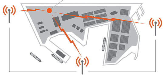
GPS and Football. Security at places where large crowds congregate is always a concern. At last month’s Super Bowl, GPS devices tracked and monitored the team vehicles. To protect the GPS, a product from Exelis was used to detect and locate GPS interference sources to protect critical GPS signal-dependent infrastructure. Eight sensors were positioned in an array pattern to detect and locate any jamming sources.
Lost in Space. Google’s Project Tango is showcasing a prototype phone brimming with software and sensors that creates a 3D map of the environment. A select group of developers has been given the device and are expected to create innovative applications, including navigation by sight. We do know that one of these devices will be heading to the International Space Station and will be part of a project to enable robots to explore the inside and outside of the craft. The terrestrial uses of the device will include being able to map the interior of a house (the sofa goes where?), navigate through complicated buildings, provide accessibility for those with impaired vision, and emergency response. Project Tango may find interesting uses with 3D printing, which is riding a wave of interest.
GPS and LED Lights. Philips has been demonstrating an indoor location-based shopping service based on location positioning from LED lighting infrastructure. The system works by using lighting fixtures that form a dense network that not only provides light, but also acts as a positioning grid. Each fixture is identifiable and able to communicate its position to an app on a shopper’s smart device. ByteLight is another company with LED indoor location technology. Wi-Fi and Bluetooth low-energy (BLE) beacons are more established for indoor positioning.
Truck Market on the Move. Market demand remains strong for mobile resource management (MRM) devices, particularly among local fleets, reports C.J. Driscoll & Associates. “Manufacturers of light and heavy commercial vehicles are becoming increasing involved with telematics,” says Clem Driscoll. “Heavy truck manufacturers are primarily focused on enabling remote vehicle diagnostics.” Many of the large MRM companies are establishing added offices around the world.
Awkward Timing. INRIX is launching Russia’s first comprehensive traffic information and driver services platform. Russia has many challenges including difficult traffic conditions. The service, available on Audi cars, was developed through an exclusive partnership with Russia’s navigation services provider cdcom. INRIX XD Traffic in Russia provides real-time traffic and incident information covering more than 236,000 kilometers of roadways across 55 cities.
-
Exelis GPS Threat Detection Helped Safeguard Super Bowl XLVIII
Signal Sentry 1000, an Exelis product that detects and locates GPS interference sources in 3D by using longitude, latitude and altitude, was deployed during Super Bowl XLVIII at the MetLife Stadium in East Rutherford, New Jersey.
During the Super Bowl, GPS devices were used extensively to track and monitor the location of team members and officials. GPS was also used to ensure that event organizers and security knew the exact location of team vehicles en route to the stadium. If a vehicle were to break down delaying the arrival of a team or game staff to the event, logistics and scheduling could have been adjusted accordingly.
“Signal Sentry 1000 helped our law enforcement officials keep thousands of fans in attendance safe during one of the most exciting nights for millions of Americans,” said Mark Pisani, vice president and general manager of positioning, navigation and timing for Exelis Geospatial Systems. “Protecting critical GPS infrastructure is extremely important for public safety.”
Signal Sentry 1000 was designed to collect actionable intelligence for law enforcement and to protect GPS signal-dependent critical infrastructures. At the Super Bowl, Exelis deployed eight Signal Sentry sensors positioned in an array pattern to detect and locate the jamming source. Threats are detected through a network of sensors, which is part of a centralized server executing Exelis-developed proprietary location algorithms.
In addition to national special security events like the Super Bowl, sensors can also be used around different types of critical infrastructure, such as utilities and government facilities, to automatically sense and locate any intentional or unintentional source of GPS jamming. Once a threat is detected, users receive specific information regarding the location of the threat in order to stop or mitigate the interference.
-
Detect and Locate GPS Jamming: Provide Actionable Intelligence
Detect and Locate GPS Jamming: Provide Actionable Intelligence
Sponsored by: Exelis
Original Broadcast Date: Thursday, December 5, 2013
Moderator: Don Jewell, Editor, Defense PNT Newsletter
Speakers: Jeff Coffed, Product Marketing Manager, Exelis Inc.; Carl Slutsky, Product Manager for Signal Sentry 1000, Exelis
Panelists: Joseph Rolli, Signal Sentry Business Manager, Exelis; Jon Schnabel, Chief Scientist, Geospatial Systems, Exelis
Summary: The Global Positioning System—GPS—is an essential element of the global information infrastructure and supports nearly every facet of modern life. However, the availability and usage of low-cost GPS jamming devices has resulted in the increased threat of intentional and unintentional disruption to commercial and industrial systems that rely on precise GPS data. That is why Exelis developed Signal Sentry 1000, a solution that enables authorities to locate with pin-point accuracy the sources of interference thereby assuring safety, efficiency, and revenue. This webinar will discuss the threat and Signal Sentry. This webcast will be of interest to anyone whose organization relies on GPS for information or commerce. -
Exelis Reaches GPS OCX Milestones for Navigation and Encryption Software
 Exelis has successfully completed several software upgrades for the new Global Positioning System Next Generation Operational Control System, or GPS OCX. Integration and testing were recently conducted on iteration 1.5 of the OCX navigation, encryption and Mission Upload Generator, or MUG, software.
The new version of GPS software will help ground controllers better understand the satellites’ exact positioning in space. The encryption software is also designed to automatically code and decode GPS signals, facilitating the exchange of user information by securely transmitting navigation payload data between the OCX ground system and the orbiting constellation of satellites.
The MUG software is responsible for creating spacecraft payload updates to refresh the navigation data transmitted to all GPS users. This data is typically generated for each satellite multiple times a day and helps to consistently minimize user error.
“These software milestones demonstrate a clear path to improved GPS accuracy and integrity,” said Drew Trainor, OCX program manager for Exelis Geospatial Systems. “Civilian and military users will have more accurate and secure GPS signals, and these milestones bring us one step closer to GPS modernization.”
Under a February 2010 contract award from Raytheon, Exelis is providing software that will simulate the behavior of GPS signals in space. In addition, Exelis is building high-precision receivers for use in ground monitoring stations placed strategically around the world. Exelis is also providing data encryptors that help ensure secure information exchange between the ground and space segments of the system.
Once the new operational control segment is implemented, GPS will improve a variety of business and economic practices, including air traffic control, crop management, and environmental monitoring, among others. The new capabilities offered by GPS modernization will also provide military users increased accuracy, availability, anti-jam power and international interoperability.