Last week, 27 members of the U.S. House Agriculture Committee sent a letter to Federal Communications Commission (FCC) Chairman Ajit Pai. In it, they urged him to reconsider the FCC’s decision to allow Ligado Networks to operate a terrestrial nationwide network that the executive branch says will cause harmful interference to GPS signals for many users.
This concern and opposition from a sector not traditionally engaged in GPS or positioning, navigation and timing (PNT) issues is just one example of how the FCC’s decision — rather than putting the issue to rest — has instead recruited a whole new set of actors from across multiple sectors for the opposition.
Many observers don’t see this as surprising.
According to one observer, previously it was easy for many to assume the FCC would reject Ligado’s proposal. The entire executive branch had been vehemently opposed for years. So had aviation groups, the weather community, geospatial interests and some satellite communications concerns. With such opposition from so many important quarters, it was reasonable for many to assume they need not become involved. Now that the FCC has acted to the contrary, these interests have become well energized.
The FCC decision also empowered opponents to educate and recruit others who don’t normally think or worry about GPS and PNT issues, folks like farmers and agricultural interests.
As one insider said, “The existing opposition can now go to just about anyone in any sector and say, ‘This is going to happen and it will harm your operation. There are no ifs, ands, or buts. The FCC has decided’.”
Photo: Avalon_Studio/E+/Getty Images
Agriculture’s reliance on GPS
Agriculture is a good example. While not the sector that first springs to mind when most people think about GPS, farming has become dependent on augmented GPS for precisely and automatically driving machinery, minimizing fertilizer and pesticide use, and a wide variety of other productivity gains over pre-GPS operations.
“GPS is critically important to the commercial agriculture, mining, forestry and rural manufacturing industries. In fact, GPS has become the single most significant technological advancement for American farm equipment in the past two decades… [A 2019 RTI study] found that during planting season, if GPS were interrupted, the economic impact to the agriculture sector could amount to losses of $15 billion due to lower crop yields. Moreover, an earlier study suggested GPS-enabled precision agriculture could save farmers an estimated 10 to 15 percent in operating costs and purchased inputs. This same study estimated the benefits of GPS to precision agriculture between $10 and $17 billion.”
Department of Transportation studies have shown that high-precision GPS receivers, such as those used in agriculture, could be impacted within 3,000 meters of a Ligado transmitters. With tens of thousands of transmitters deployed in a nationwide network, this could pose a real problem for American farming.
Other sectors have also become involved in the opposition. The recently formed Keep GPS Working Coalition has members representing aviation, surface transportation, maritime, agriculture and equipment manufacturing.
This formal and public coalition, though, seems to be just the tip of the opposition iceberg.
Almost 100 dissenting organizations
According to some involved with protesting the FCC’s decision, there are nearly a hundred organizations and companies that are working in some way to have it overturned. These include multiple aviation, delivery service, agriculture, surface transportation, geospatial, weather, maritime, space and technology interests.
One sign of the influence they are having is an increase in concerns being expressed by members of Congress.
In addition to the agriculture letter, some of the most powerful recent examples are statements made during meetings of the influential House Committee on Appropriations. Rep. Ken Calvert (R-CA), ranking member of the Defense Appropriations subcommittee, spoke at length in opposition to the FCC’s action. His comments were followed in a similar vein by the vice chair of the Appropriations Committee, Rep. Peter Aguilar (D-CA).
Many of the questions being asked by the public and members of Congress alike were reflected in the letter from the Agriculture Committee members:
How did the FCC know that “its” tests were representative and valid?
Why does the FCC find that some degradation of GPS reception is acceptable?
Why did the FCC reject the executive branch’s testing criteria?
Was there a cost/benefit analysis?
The letter also asked the question that is on almost everyone’s mind: If and when there are problems, who is going to fix them?
One-inch GNSS accuracy in under a minute, delivering seamless high-precision performance across the U.S. and southern Canada
Trimble has completed expanding its CenterPoint RTX Fast correction service, with coverage now spanning the contiguous U.S. and southern Canada. This expansion is central to Trimble’s vision to transform how and where users can leverage precision and accuracy.
Coverage of Centerpoint RTX Fast. (Image: Trimble)
Designed for autonomous applications in both on-road and off-road markets, the coverage and performance of the service enables industry professionals to re-think what is possible when using augmented positioning for improving safety, performance, productivity and operational efficiency.
The CenterPoint RTX Fast subscription service delivers horizontal positioning accuracy of 1 inch (2 centimeters) or less in under a minute, with the versatility of satellite or cellular delivery. This expanded coverage makes it the largest, high-performance GNSS correction network in the world, according to Trimble.
Base stations not required. The service encompasses more than 5 million square miles across North America and Europe. By using the service, said Trimble, farmers, land surveyors and GIS professionals can untether from the cost and complexities of GNSS base stations.
In addition, Trimble RTX Fast offers a single, continuous correction technology platform for enabling a broad range of safety-critical autonomous applications in markets such as automotive, agriculture and construction.
“This achievement is a major milestone in the continuous evolution of our correction service and autonomy strategy. We are delivering unmatched access to fast, reliable, highly accurate positioning in more areas than ever before,” said Patricia Boothe, senior vice president of Trimble’s Autonomy Sector. “Whether enhancing performance in the autonomy ecosystem or simplifying traditional mapping and surveying workflows, RTX Fast users can gain greater accuracy to improve productivity and operate safely — ultimately transforming the way they work and drive.”
CenterPoint RTX Fast subscriptions for Trimble RTX-compatible GNSS receivers are available through Trimble’s Authorized Business Partners or Trimble’s online store.
The use of drones for precision agriculture is gaining momentum because of their capability to deliver the most updated information fast and efficiently. UAVs are transforming how agriculture is done. By implementing drone technology, farms and agriculture businesses can improve crop profit, save time, and make land-management decisions that improves long-term success.
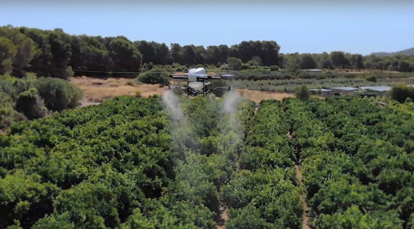
A few weeks ago Quaternium tested its innovative HYBRiX drone to spray fertilizers in the orange fields near Valencia, Spain. With its system of longer-than-average flight-duration, farmers have the opportunity to monitor and spray their fields precisely and rapidly.
“I am really glad to see that the entire spraying process in my orange fields has hardly taken six hours,” said farmer Pedro Andreu while operating the HYBRiX. “With other drones, we had to spend multiple hours waiting for batteries to charge and days to finish the work.”
The test convinced Andreu to use the technology to simplify his work. He engaged farmers in the neighborhood to join him and implement this technology in their work as well.
Alicia Fuentes, Quaternium CEO, accompanied the team for the field demonstration. She noted that farmers could benefit by using precision farming technology in a variety of ways: monitoring the health of their crops, estimating soil conditions, planting future crops, fighting infections and pests, updating the health of plants, and livestock monitoring.
Hybrid fuel system. HYBRiX UAS operates using a hybrid electric-fuel system. This makes it easy to operate the multi-rotor drone through the fields of a farm for an entire work whole day by refilling the spraying tank when needed and the fuel tank every 2-3 hours. Its built-in capacity of 5 liters of fuel enables HYBRiX to surpass the flying time from minutes to 2 to 4 hours.
The powerful propulsion system of HYBRiX allows the aircraft to carry up to 10 liters of liquid, with a maximum takeoff weight of 25 kg. The combination of hybrid power with its increased range extender capacity allows the farmer to cover large acres of land without carrying uncomfortable batteries and ensure long flight time in the field with the aircraft.
Quaternium is now focused on refining this technology to extend crop protection across the country so that farmers can benefit from the outcome to make their work more efficient.
Agriculture equipment maker Case IH is enhancing the robustness of its RTK+ correction signal network by adding the European Galileo system to the compatible satellites with which it works.
The move will increase levels of signal reception and reliability for farmers using Case IH RTK+-guided autosteering and related technologies.
Real-time kinematic (RTK) systems typically depend on signals from the American GPS or Russian GLONASS satellite networks, both designed primarily for non-civilian use. To give European Case IH users a reliable alternative when using RTK+-guided steering systems with their sub-1.5-centimeter repeatable accuracy, Case IH AFS RTK+ now also uses Galileo.
The addition of Galileo to the global GNSS constellation helps minimize the risk of signal failure, a key driver for the integration of its signals into the Case IH AFS RTK+ signal system. European satellite network independence is a principal objective, but Case IH AFS RTK+ is also designed to be compatible with existing and planned GNSS satellites and interoperable with GPS and GLONASS.
Galileo benefits farmers by minimizing downtime from waiting for lost signals to be regained, and ensures consistent efficient use of seed, fertilizer and crop protection products through parallel passes with minimal overlap, thereby maximizing crop potential.
“The use of GNSS technology is opening up new productivity levels and opportunities in European agriculture, providing farmers with an unprecedented level of knowledge about their crops, livestock and operations while making the sector more efficient, economically competitive and environmentally sustainable,” said Maxime Rocaboy, product marketing manager, AFS technology, at Case IH.
“Enhanced RTK+ accuracy through incorporation of signals from the Galileo satellite system is a core way in which we can help Case IH tractor and combine users be innovative and competitive as they seek to help develop a sustainable agriculture to feed an ever-increasing world population in an environmentally responsible way,” Rocaboy said.
Special section, October 2018 GPS World. Cover photo: PrecisionHawk
If you blink, you might miss something! The examples here represent only a fraction of this booming field, but they show how diverse drone use has become. Interspersed among them, this article offers further insights on technology integration, the regulatory outlook and the economic future of this fast-moving industry.
By Tony Murfin, Contributing Editor, UAV & Professional OEM
Capturing where the drone industry has been this year and where it is headed in 2019 resembles trying to describe a Florida thunderstorm: how can there be so much rain so quickly, how long will it last, and what will the landscape look like afterwards? (I’m writing this during just such a deluge near Venice on the Gulf Coast.)
The UAV/UAS industry has grown at such an amazing rate, it’s almost impossible to count or describe all the applications that have become normal practice, not to mention the number of companies involved in either making drone platforms or supplying drone integrators with sensors: GNSS, inertial, lidar, cameras photographic, thermal, infrared, video and more.
From accident reporting to crop monitoring to infrastructure inspections, drones are, so to speak, on the rise. This year we have seen substantial increases in investments by equipment suppliers, continuing funding for military businesses, prototype systems for remotely identifying and even taking down drones, and vastly expanded use in mapping and survey.
As precision guidance, autonomous operations, high-definition geocoded images and high-volume data processing all improve, drone usage will continue to increase. OEM receiver manufacturers, sensor suppliers and data-handling companies play key roles in development, and stand to profit thereby.
The Delair Septentrio UX11 mapping UAV. (Image: Septentrio)
In particular, use of drones is growing in land management, construction, mining and farming. An open-pit mine operation can be supported through detailed drone inspection producing high-resolution images. Processed images and data enable keeping tabs on inventory, site changes over time, identifying best areas for further extraction, and monitoring and managing vehicle movement. These tasks required huge amounts of time in the past. Drone overflight and processing tools condense all the effort as well as producing enhanced results to enable faster and clearer decision-making.
Surveillance and reconnaissance are probably the biggest military drone applications. Carrying payloads that include color video cameras and infrared night vision cameras, more than 19,000 drones are now in the arsenal of the U.S. Army, Air Force, Marines and Special Ops, and more have gone to other nations’ militaries. Some fly at relatively low altitude, with limited range and powered by a single quiet electric motor; these drones have become essential in gathering forward-situation intelligence.
The following examples represent only a small part of the industry. I selected them here to show how diverse drone use has become. Interspersed among them, I’ll offer further observations on technology integration, the regulatory outlook and the economic future of this fast-moving industry. If you blink, you might miss something!
Accident Investigations
In the past, when police arrived at a serious traffic accident, investigators had to use tape measures and roller wheels to construct an accurate physical record of the incident. More recently, police have used laser measuring tools but this still entails time-consuming procedures and produces traffic back-ups. Now police departments have started to collect highly accurate aerial images of traffic incidents using drones, and it’s proving quicker and more efficient.
UAVs collect photos and videos, and software then stitches multiple high-resolution images together into a 2D or 3D map. With geolocation annotation provided by the drone, investigators can then take measurements directly from visual accident records.
Previously, an investigation could take up to three hours gathering information manually, but with a drone overflying and documenting an accident this might be reduced to around 45 minutes. This clearly saves time and money for the police as well as drivers who suffer shorter traffic delays. With an investment of about $15,000 in drone hardware and training, payback can happen pretty quickly.
Overall UAV Market Growth
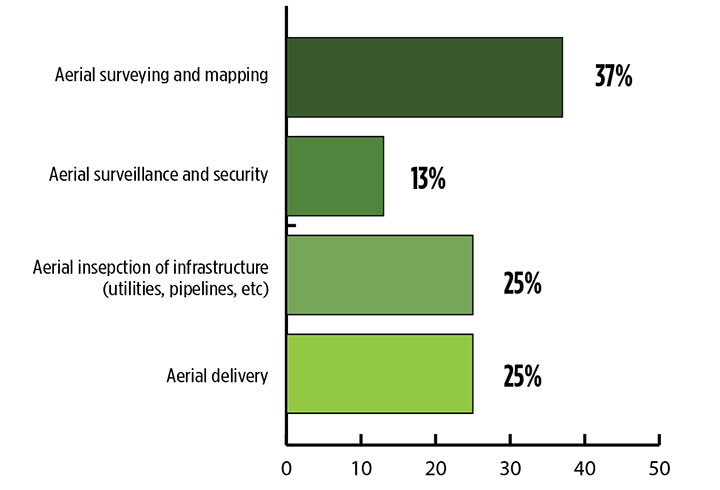
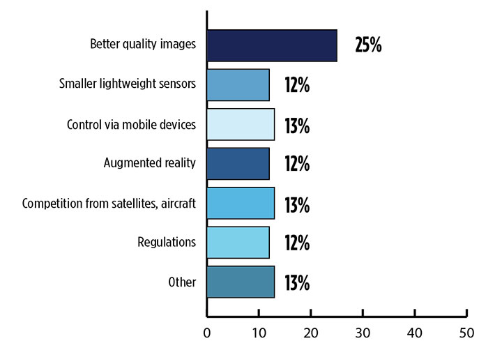
What is the killer app for drones? What professional UAV market sector will most powerfully drive adoption and influence new regulations for unmanned aerial vehicles? (Source: GPS World 2018 State of the GNSS Industry survey)
The drone logistics and transportation market was estimated to be valued at US $11.20 billion in 2022 and is projected to reach $29.06 billion by 2027, at a combined annual growth rate (CAGR) of 21.01%, according to India-based MarketsAndMarkets Research, in its May 2018 report.
The logistics and transportation market was defined to include warehousing, shipping, infrastructure, software, military, freight, and even passenger and ambulance drones. “The increasing use of unmanned aerial vehicles in civil and commercial applications for faster delivery of goods is one of the most significant factors expected to drive the growth of the drone logistics market,” stated the report.
The shipping segment is indeed projected to grow at the highest CAGR, as drones will see increasing use to transport a range of products from small packages to medical supplies and food. Venture capitalist investment in this market has been substantial as well as significant commitments by companies such as Amazon, Google, and Walmart in research and development to commercialize drone delivery services.
Couple that with another report from the same company report on the drone analytics market, valued at $1.17 billion in 2016 and projected to reach $5.41 billion by 2022, at a CAGR of 28.11% from 2017 to 2022. The drone analytics market was considered to encompass agriculture and forestry, construction, insurance, mining, utilities, telecommunications, oil and gas, and scientific research.
Both reports note that “The imposition of restrictions by various government agencies on the use of UAVs in civil and commercial applications is one of the major challenges faced by the drone logistics and transportation market.”
In February of this year, MarketsandMarkets estimated that the overall UAV market was valued at $18.14 billion in 2017 and projected to reach $52.3 billion by 2025, at a CAGR of 14.15%.
Agriculture
Results of a survey of 269 farmers by Munich Reinsurance America indicate that three quarters of all farmers in the U.S.— from those with less than 100 acres to those with more than 5,000 — have either begun to use drones for precision agriculture, and monitoring crops, livestock and soil conditions, or are thinking about using drones. Roughly half of these farmers contract out the work to drone service suppliers and most use drones either daily or more than once a week.
Sensor Integration
What is the biggest challenge for the UAV industry? (Source: GPS World 2018 State of the GNSS Industry survey)
As the size, weight and power (SWAP) and the accuracy of sensors continue to improve, drone use will continue increasing steadily. OEM receiver manufacturers, sensor suppliers and data-handling companies play key roles in this vital and ongoing development, and stand to profit thereby.
Making it all work is a combination of sensor payloads gathering inertial and GNSS location, stills and video, lidar, thermal and hyperspectral data; the secret sauce lies in how the data is processed and presented to users. All these areas show significant growth. The following are only a few key examples.
Lidar. Light detection and ranging (lidar) detects and measure the distance of an object or surface from an optical source, in this case a hovering or cruising UAV. GPS and inertial provide geo–referencing per each scan point.
Lidar has seen increasing application in surveying and engineering, GIS mapping, accident scene reconstruction, topographic and coastline mapping, digital elevation model and digital surface model generation, mining and quarries, gas and oil pipelines, railroads and other infrastructure. As hardware costs decline, software begins to play more and more of a major role, becoming a larger part of the solution in every way.
The M200 Snoopy series lidar package from LidarUSA is designed specifically for integration aboard the DJI M200 UAV. The laser scanning has a 100-meter maximum range, yielding 4-5 cm accuracy. It carries a tactical grade L1/L2 GPS/IMU unit and weighs 1.63 kg.
Inertial Miniaturization. UAVs are driving even further size-downs of other navigation sensors as well.
As just one example, the miniature μIMU from Inertial Sense incorporates a magnetometer, barometric pressure sensor, and L1 GPS (GNSS) receiver. Angular rate, linear acceleration, magnetic field, barometric altitude, and GPS location outputs are at 1 KHz with UTC time synchronization.
ADS-B.Aerobits in Poland has developed a high-speed, miniaturized (23.0 x 18.0 x 2.5mm & weighing 2 grams) Automatic Dependent Surveillance-Broadcast (ADS-B) module which provides detect-and-avoid for small UAVs. The module accepts external GNSS position inputs and has high speed on-chip processing which enables processing of thousands of ADS-B signals/second from other aircraft/drones. Aerobits claims a reception range of over 200 miles due to a high-sensitivity RF front-end. With FAA-mandated equipage coming for aircraft in 2020, this potentially offers a detect-and-avoid option for even small drones.
Regulatory Outlook
The Association for Unmanned Vehicle Systems International has been an industry voice for more than 40 years. AUVSI president Brian Wynne recently told Congress what needs to be done to fully integrate UAS into the National Airspace System — a critical step in further drone development and growth.
Initial regulations governing civil and commercial UAS operations are now in place. The FAA’s small UAS rule, known as Part 107, established a flexible, risk-based approach to regulating UAS and reduced many barriers to low-risk civil and commercial UAS operations. Since its enactment in 2016, however, demand for commercial UAS has exploded.
“As of March 2018,” Wynne stated, “more than 150,000 platforms have been registered for commercial use. The FAA expects more than 450,000 UAS to be flying for commercial purposes over the next five years.” That’s three times as many as today!
Waivers to Part 107 permit their holders to operate at night, as well as in certain restricted airspaces, beyond line of sight and over people. More than 1,700 operators across the U.S. have received these waivers.
Continued adoption of unmanned flight will require an expanded regulatory framework that extends the waiver provisions much more widely. There are many challenges to this, particularly security concerns. A key step will be “implementing a remote ID system that identifies any UAS flying in the airspace, in real time.” according to Wynne.
The FAA reauthorization bill recently passed by the House of Representatives calls for rulemaking concerning carriage of property, a necessary step for allowing UAS package deliveries — the next big thing.
Military UAV Business Strong
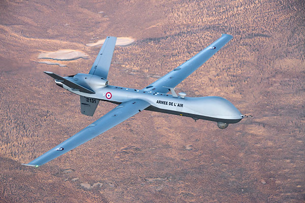
French MQ-9 Reaper. (Photo: DoD press release/UAS Vision)
Military business remains a major source of revenue for the UAV/UAS industry, as demonstrated by the recent award of several contracts to various drone suppliers.
U.S. Naval Air Systems Command recently awarded Insitu a ~$54 million fixed-price contract for four production RQ-21A Blackjack unmanned aircraft systems and eight attrition air vehicles: seven for the Marine Corps and one for the government of Poland. The contract includes ground control stations, launch and recovery equipment, shipboard equipment kits as well as systems engineering and program management support.
U.S. Army Contracting Command recently awarded General Atomics Aeronautical System Inc. (GA-ASI) a Grey Eagle engineering support contract worth ~$11m. Work will be undertaken at the GA-ASI facilities in Poway, CA and will run through to Sept 30, 2019.
GA-ASI has also just won an FMS (Foreign Military Sales) contract worth $123 million for MQ-9 Reaper systems for France – deliveries are expected to be completed by May 2020. An FMS contract is normally how a foreign government procures U.S. government military equipment. The foreign government contracts with a U.S. agency, and the U.S. agency awards a back-to-back contract to the U.S. supplier. In this case, the U.S. contracting authority is the Air Force Life Cycle Management Center at Wright-Patterson Air Force Base.
The U.S. Missile Defense Agency has awarded General Atomics Electromagnetic Systems (GA-EMS), San Diego, California, a contract worth up to ~$134 million to develop, integrate, and flight test an advanced sensor into the MQ-9 UAV. The work will be performed in San Diego, California from August 2018 through October 2021 with realistic flight testing scenarios taking place both within the U.S. and elsewhere.
At the end of August, Boeing won the contest for the U.S. Navy’s unmanned refueling tanker with an $805 million contract award. The award covers the development and manufacturing of an initial four air vehicles. The future MQ-25 Stingray will be the first UAV to operate from U.S. aircraft carriers to refuel and extend the range of several combat aircraft.
L3 Technologies has won a U.S. Army $454M contract to build, deliver and support an electro-optical infrared laser designator for the RQ-7Bv2 tactical UAS. The drone mounted payload will help the Army manage battlespace situational awareness, increase UAS survivability and obtain imagery for target/threat detection.
Counter-UAS Systems
DroneShield out of Australia markets a drone detection and mitigation system, known for its DroneGun, a point-and-shoot device able to disrupt multiple RF frequency bands simultaneously (433MHz, 915MHz, 2.4GHz & 5.8GHz), taking out the communication link to a drone operator — and also GNSS signals when so equipped — up to 1km away.
The full DroneSentry detection system integrates a suite of sensors and countermeasures including radar, optical, RF listening, acoustic, thermal and an RF countermeasure transmitter with greater power/range than the portable DroneGun.
Survey and Mapping
SenseFly recently completed work on a three-year construction project in Northern Ireland to build the new A6 highway. A senseFly eBee Plus drone provided detailed aerial coverage and minimize interruptions with road traffic and ongoing quarry operations.
Adopting an integrated aerial approach enabled the construction contractor to quickly obtain detailed, accurate, professional-grade data, and has helped save time and resources. Reducing the time required in the field and proximity to dangerous quarry sites optimized the mapping task
High-Precision Survey Drone. The TRIUMPH-F1 UAV is built around the JAVAD GNSS TRIUMPH-1M receiver, the company’s high-precision geodetic GNSS receiver with 864 channels to track all current and future GNSS signals.
When used on the ground, the TRIUMPH-F1 can function as a TRIUMPH-1M base or rover. The four motor arms (for eight motors) are detachable. Four screw inserts in the bottom to attach the TRIUMPH-F1 to a pole mount for field use.
The TRIUMPH-F1 features user-friendly mission programming. The four lithium polymer batteries that power the eight propeller motors, arranged in a stacked quad formation.
The TRIUMPH-F1 also has two micro-SD slots for image storage, a SIM card slot, a USB connector for uploading flight plans and downloading collected images, and indicators for satellite tracking and communications. Other indicators are dedicated to flight status and gyro.
Vertical Landing.WingtraOne’s vertical landing technology enables touchdown in confined areas as small as 2 m x 2 m like boats or forest lanes. Combined with a flight range of up to 50 km, this makes large-coverage mapping missions feasible
The vertical-take-off-and landing (VTOL) drone WingtraOne is designed to safeguard its valuable sensors and eliminate wear and tear of the equipment. Instead of broken wings or damaged cameras from belly landings and parachute touchdowns, the WingtraOne lands gently. During the vertical descent, laser sensor data enables the WingtraOne to sense the ground and land safely even on rocky or hilly hilly terrain.
In case of a changing landing environment like a drifting boat or recently parked cars, the landing spot can be adjusted easily.
The WingtraOne works truly autonomously during its entire mission, including take-off and landing. Instead of catapult or hand launches that can cause injuries or damage equipment, the WingtraOne takes off vertically without any human interaction.
Shipping and Logistics
Matternet, based in Switzerland, is testing deliveries using drones under a 3-year program run by the North Carolina Department of Transportation. The NC program is one of 10 authorized by the FAA to evaluate the commercial use of drones.
The objective is to transport small items like blood samples, but initially vials of water will take the ride from a medical office building before landing on a hospital roof. In March, the company was authorized to operate drones over populated areas in Switzerland, carrying samples to hospitals in Lugano.
Items can be securely deposited into the drone station for pick up or retrieved following delivery. A smartphone application is used to authorize pick up and delivery. The item is then scanned for pick up, the station automatically installs the item into the drone for transport, the drone then departs for the assigned destination and on arrival, scanning is required to retrieve the delivered item at the other end.
Conclusion
These examples just skim the surface of an exploding industry which just keeps on keeping on, constantly developing new solutions and applications. High-altitude pseudo satellite drones, drone delivery of goods within minutes of placing an internet order, automated drone facility inspections, power via wireless to keep drones airborne, parachute safety systems for drones….the list goes on and on.
Clearly the UAV/UAS industry has only begun its journey. There are many unexpected places we can look forward to it visiting in coming months and years.
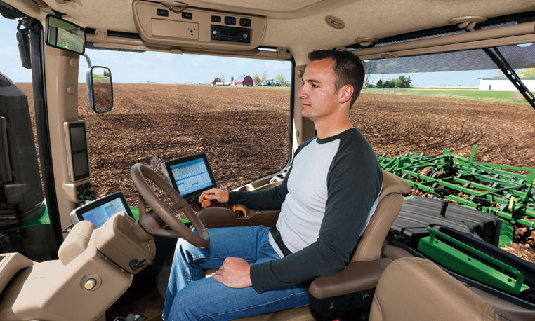
Google and the big automakers might get the lion’s share of attention when it comes to autonomous road vehicles, but John Deere has been making self-driving tractors for more than 15 years.
Among them is the 9RX tractor, which can steer itself, freeing the farmer to focus on business. The 9RX, introduced in August, features an articulated steering system and an optional Active Command Steering (ACS), which improves maneuverability in the field and line-holding ability at transport speeds.
Hands-free driving: Ag companies take the wheel. (Photo: John Deere).
Farmers don’t need to navigate other traffic, just make optimal use of fields. Before farmers began using GPS to plan routes, a few feet would get reworked in every row. With GPS-based auto-driving accurate down to the inch, missed spots and repetition are avoided, saving farmers time, fuel and money.
With a tractor the only moving object in a vast acreage, collisions are highly unlikely. Still, a driver still needs to be at the tractor’s wheel. Unlike consumer vehicles being developed for autonomous operation on public roads, the tractors don’t have external sensors on all sides to prevent collisions. A fully autonomous tractor, which doesn’t require a driver, probably won’t hit the market before 2025, according to John Deere.
Inside the cab, farmers can equip their tractors with a variety of modular systems that allow computers control over operations, starting with a basic satellite guidance system and a touchscreen interface. From there, an add-on lets the tractor make precise turns autonomously, and another uses radio base stations set up around fields to supplement navigational accuracy. Besides the high-tech features, cabs of the 9RX have luxury touches such as an integrated refrigerator and high-quality sound.
Laser Navigation
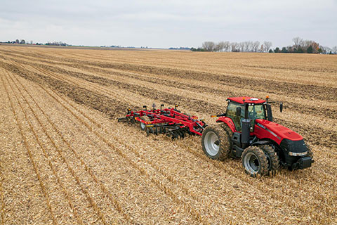
Other companies that offer auto-steering include Case IH and Autonomous Tractor Corporation.
Case IH offers guidance and steering for use on tractors, such as its Magnum 340 Tractor. (Photo: Case IH)
Case IH provides steering and guidance tools for tractors, combines and sprayers. Its AFS AccuGuide auto guidance enables repeatable accuracy down to sub-inch levels. AFS RowGuide works with AFS AccuGuide to provide accurate, hands-off steering for corn harvests. Two mechanical touch sensors mounted on the corn-head dividers sense row position and provide guidance input in concert with GPS.
Autonomous Tractor bills itself as a non-GPS system without dead spots or signal interference. Instead, it uses a proprietary laser-radio navigation system (LRNS) for sub-inch positioning data, along with its own FieldSmart software that allows farmers to “train” the tractor without programming.
Sonar systems provide full perimeter safety, and pan-tilt cameras communicate via cellular to allow the farmer to monitor progress and remotely resolve issues.
Trimble will acquire the assets of privately held AGRI-TREND of Red Deer, Alberta, Canada, which operates the largest network of independent agricultural consultants in North America. The acquisition will enable Trimble to provide agronomists and other crop advisors with a stronger set of brand-agnostic tools they can use to advise growers on how to better manage their operations, Trimble said in a news release.
The acquisition is expected to close in November 2015. Financial terms were not disclosed.
AGRI-TREND’s network of more than 200 specialists spread throughout the U.S. and Canada includes 110 independent “coaches” specializing in agronomy, precision farming, crop marketing and farm business management. Coaches are supported by a team of science specialists comprised of 30 Ph.D.s and M.Sc.s providing in-house research, training and insight support for both the coaching network and the AGRI-DATA Solution platform — a proprietary farm data-management solution. As a result, AGRI-TREND’s solutions enable growers to make informed business decisions that better allocate scarce resources to produce safe and environmentally sustainable food.
“Trimble’s acquisition of AGRI-TREND is another step towards total farm management for the grower. Together with Connected Farm, we will provide growers and their trusted advisors with a combined offering that is unique in the marketplace today,” said Joe Denniston, vice president for Trimble’s Agriculture Division. “AGRI-TREND is a leader in providing expert advice and decision support for growing crops, marketing commodities and managing a farm’s finances. Trimble is a leader in precision agriculture technology that precisely applies those decisions whether it is seed, nutrients or water. Together, Trimble and AGRI-TREND will enable the integration of decisions and execution to give greater control over the outcome, resulting in maximized productivity for the grower.”
“AGRI-TREND has been working side by side with farmers for over 17 years. With the strength that Trimble provides, we aim to help even more farmers as the move to precision agriculture continues to gain momentum globally,” said Rob Saik, founder of AGRI-TREND. “The combination of our advanced agricultural technical expertise and Trimble’s exceptional precision agriculture tools provides us with a platform that will support production practices that are sustainable both from an environmental and financial perspective for today’s farmers. We’re excited to be a part of the future of agriculture, and we’re pleased to work with the great people at Trimble.”
Full Farm Support
Grow the Crop: To assist in optimizing crop growth, AGRI-TREND has a network of experienced agronomists who serve as a personal Agri-Coach to help farm customers assess the performance of every acre on a yearly basis. Agri-Coaches work on the analytics, looking at the cost of production as well as nitrogen and water use efficiency, interpreting the data and making customized recommendations for each field. Recommendations are then followed up with field scouting and performance tracking to ensure farm goals are met.
Sell the Crop: To maximize crop sales, AGRI-TREND creates a Strategic Marketing Plan that includes business analysis, operational strategy, risk management and a harvest review. This customized plan is developed by an AGRI-TREND Market-Coach who works closely with each farm client to understand the unique situation of their farm and the cost of production for each field. The AGRI-TREND Market-Coach then provides advice on how to best achieve better selling prices, risk mitigation and optimal cash flow for their farm customers.
Manage the Money: In order to enable farmers to better manage their money, AGRI-TREND provides a network of business-coach professionals, which consists of experts in specialized areas such as accounting, banking, corporate finance and insurance. The business-coach starts by gaining an understanding of the farm business including strengths and weaknesses, measuring the farm’s performance against benchmarks, creating the Strategic Farm Business Plan and then implementing the farmer’s long-term growth plan.
The AGRI-DATA Solution
The AGRI-DATA Solution is a complete farm management platform that focuses on the unique agronomic challenges that farmers face every year as they work to maximize yields and profits. This platform is the foundation for AGRI-TREND advisors as they work on crop planning, crop input tracking, soil sampling, tissue testing, manure analysis, fertilizer blending, field scouting, harvest data tracking and more. The platform supports over 75,000,000 legacy acres with over eight million acres added in 2015. Farmers have also adopted the AGRI-DATA mobile applications for both Android™ and iOS devices, preferring to work with their information on the go.
Trimble Connected Farm Advisor
Trimble Connected Farm Advisor — a field data management tool for the farmer’s trusted advisor — will be integrated with the AGRI-DATA platform to empower AGRI-TREND coaches with a greater toolset to deliver more services to their growers.
PrecisionHawk and Genera Energy have partnered to develop new analysis algorithms specific to improving the efficiency and quality of sustainable biomass crop production and distribution. The algorithms will convert raw aerial imagery collected by drones and satellites into an actionable report for biomass crop farmers. The tools will be publicly licensed for use in the DataMapper software platform.
Within the DataMapper software platform, Genera will license the completed tools in the Algorithm Marketplace, DataMapper’s library of sophisticated algorithms for data analysis. The store automatically interprets data collected from a drone’s geographic information system during flight. The Genera algorithms will add to the currently available lineup of algorithms serving the agricultural industry such as assessing plant characteristics, identifying pests, and monitoring disease pressures.
Since 2008, Genera Energy has been an industry leader in biomass supply and supply-chain services. The first group of research tools to be developed under the new partnership will focus on lignocellulosic crops, core to Genera’s expertise.
“Working with PrecisionHawk to develop advanced data collection and analysis tools elevates commercial-scale biomass supply chains to the forefront of technological innovation for crop management, risk reduction, and efficiency,” said Sam Jackson, vice president of Business Development at Genera. “PrecisionHawk is the leading company in remote sensing in a variety of industries, including agriculture. Partnering our agronomic knowledge and skills with their outstanding technology platform is a win not only for us, but for the entire biomass industry.”
“This partnership is a great opportunity to develop decision support tools that provide a more sustainable and efficient path for energy production,” said Allison Ferguson, director of Education and Research Partnerships at PrecisionHawk. “Genera Energy has built an impressive reputation in agriculture and energy, and we look forward to offering this suite of useful solutions for the betterment of the industry.”
Marketsandmarkets.com is offering a new report on the precision farming market, with forecasts to the year 2020. The report covers various technologies and components, including GNSS.
The report is titled “Precision Farming Market by Technology (GPS/GNSS, GIS, Remote Sensing & VRT), Components (Automation & Control, Sensors, FMS), Application (Yield Monitoring, VRA, Mapping, Soil Monitoring, Scouting) and Geography – Global Forecasts to 2020.”
According to marketsandmarkets.com, “Precision farming is growing rapidly from its infancy towards maturity. Driven by advancements in data management, precision farming has a remarkable impact on traditional approaches to farming. Applying technological developments in data collection and geo-location tracking, precision farming uses technology to optimize yield and detect operating efficiencies as well as deficiencies. Precision farming applications guide farmers about the right time to plant and harvest, and the amount of fertilizers and pesticides needed for better yield production. This information helps cut down input costs, fuel usage, and labor, and negate the environmental impact. Farmers across the globe have been benefitted due to innovations in precision agriculture.
“Major drivers for this market are augmented yield and profitability, which are contributing factors for farmers to opt for precision farming; other drivers like energy and cost saving, and government assistance have also been contributing to the market growth. Major restraints like high initial investments, and lack of awareness and their impact analysis are also covered under this study.
“The total precision farming market size is expected to grow at a CAGR of 12.2% from 2014 to 2020 and reach $4.55 billion by 2020. The report analyzes the precision farming supply chain, giving a very clear insight of all major segments and supported segments to the industry. The report also provides a detailed scrutiny of the Porter’s five force analysis for the market. All five major factors in these markets have been quantified using internal key parameters governing each of them.
“The report also includes company profiles of leading players in this industry with their recent developments and other strategic business activities. The competitive landscape section of the report entails key growth strategies and detailed market share analysis of key industry players. Some of the major players in the precision farming market are AgJunction Inc. (U.S.), Ag Leader Technology (U.S.), Dickey-John Corporation (U.S.), Teejet Technologies (U.S.), Deere & Company (U.S), Trimble Navigation System (U.S.), Precision Planting Inc. (U.S.), ACGO Corporation (U.S.), Topcon Precision Agriculture (U.S.), and Raven Industries Inc. (U.S.).”
A new app available on the Google Play store enables farmers to use their smartphone in the field.
AgriBus-NAVI is a GPS guidance system to mount on agricultural machinery such as tractors, combines and self-propelled sprayers to help with straight-line tasks in the field. Checking the display while driving will enable the creation of straight and evenly spaced lines in large fields.
The app, which is compatible with Android 4.0 and above smartphones and tablets, doesn’t offer the automatic steering functionality that dedicated precision agriculture GPS devices usually do.
The app, by Agri Info Design, is based on the software “Agricultural Vehicle Navigation Software for Field Operation” and a patent “JP-4572417-B2” developed by National Agricultural Research Organization (NARO).
According to a new market research report published by MarketsandMarkets, the total Yield Monitoring Devices and Services Market is expected to reach $2.51 Billion by 2020, growing at a CAGR of 7.17% from 2014 to 2020.
The report, “Yield Monitoring Devices and Services Market by Technology (GPS/GNSS, GIS, Remote Sensing), Components (Sensors, GPS/GNSS, Display, Guidance & Steering, and Software & Services), Application (VRA, Field Mapping, Soil Monitoring, and Scouting), and Geography – Global Forecasts to 2020”, is available now. It includes 65 market data tables and 64 figures spread through 208 pages and an in-depth TOC.
Yield monitoring is considered by farmers to be essential as yield data is recorded automatically while harvesting crops. Yield monitoring and mapping offers many other on-farm and off-farm benefits such as real-time availability of information, creation of a spatial database, and evaluation of whole-field improvements. Yield monitoring devices and services are implemented for site-specific farming, which ensures better efficiency, high yield, and profitability with optimum usage of resources. Yield monitoring techniques have major applications in variable rate application (VRA), soil monitoring, field mapping, and crop scouting.
Despite the rapid growth of global commerce and the widespread availability of equipment for yield monitoring and VRA, adoption rates appear to differ sharply from one country to another. The increasing demand for food is propelling the growers to adopt yield monitoring techniques and optimize their resources efficiently with minimum wastages.
The report provides a detailed segmentation by technology, component, and application. The geographic analysis covers all existing and emerging technologies in the yield monitoring devices and services market. The market based on technology is segmented into guidance system and remote sensing. The market based on hardware components and software is segmented into hardware components such as sensors, GPS/GNSS devices, display devices, guidance, and steering; and software services such as yield data management software as well as consulting and training services. The report also covers major applications of yield monitoring techniques such as field mapping, VRA, soil monitoring, and crop scouting with qualitative and quantitative industry insights.
One of the objectives of the report is to analyze market trends for each of the Yield Monitoring Devices and Services Market segments and their respective growth rates. Apart from market segmentation, the report also covers an in-depth analysis such as Porter’s five force analysis, supply chain with a detailed process flow diagram, and market dynamics such as drivers, restraints, and opportunities for this market.
Trimble is offering a new agronomic service that is part of its Connected Farm solution. The new service, Soil Information System (SIS), provides farmers and their trusted advisors with in-depth 3-D soil data they can use to make more informed decisions about their crop production goals.
The SIS data is accessed through Connected Farm and can be used with Trimble’s Farm Works farm management software or other GIS platforms. Connected Farm enables better decision making by providing one central location for accessing key information impacting farm operations such as rainfall totals, weather forecasts, commodity tracking, planting coverage, yield mapping, fleet management, and irrigation monitoring and control, Trimble said.
The SIS 3D soil mapping technology uses advanced sensors along with intelligent targeting and geoprocessing algorithms to produce high-resolution, accurate soil and topographic information. By providing a greater understanding of the physical and chemical characterization of the soil, including how inputs move through the soil, SIS enables farmers to initiate more effective solutions to resolve the unique challenges of each area of their fields. The SIS solution outputs precise, multi-layer soil models that are more comprehensive than traditional methods used in the industry today. Some examples of map types include: root zone depth, soil texture, plant available water, compaction depth, macro and micro-nutrient levels, soil nutrient holding capacity, and salt and toxicity concentrations.
By analyzing soil variability and patterns prior to sampling — and by using its industry-exclusive data acquisition and analysis software — SIS provides targeted recommendations on the best locations where soil samples should be taken. In some cases this reduces the number of samples required to provide high-quality information by as much as 60 percent over traditional sampling methods. As a result, the solution enables agronomists to be more efficient with in-field data collection, providing valuable time and operating cost savings.
“By adding the Soil Information System solution to Connected Farm, Trimble is providing farmers and their agronomists with critical soil information they can use to improve crop production and benefit the bottom line,” said Levi Kettle, Connected Farm business area director of Trimble’s Agriculture Division. “For example, knowing the soil’s plant available water capacity can aid in irrigation layout, scheduling, moisture sensor targeting, root stock selection and many other management decisions.”
“Variability in yield and quality are due primarily to non-uniform soils being managed as uniform soils. In the past, our inability to identify the components of this soil variability prevented us from achieving greater crop uniformity and better economic returns,” said Robert Wample, Ph.D., a plant physiologist and owner of Edgeknoll Consulting, an SIS service provider. “SIS allows us to take a proactive approach to overcoming soil variability, and when combined with geo-referenced variability in crop yield and quality, the effectiveness of this approach is enhanced even more resulting in an ‘agricultural forensics’ approach to precision agriculture.”
The SIS solution is available in several service levels depending on the accuracy and resolution required for the particular crop type and the grower’s production goals.