Plans to harness Galileo and other satnav systems for next-generation satellite augmentation systems for aviation and other high-performance uses took a significant step forward at the latest gathering of worldwide operators and experts, reports the European Space Agency.
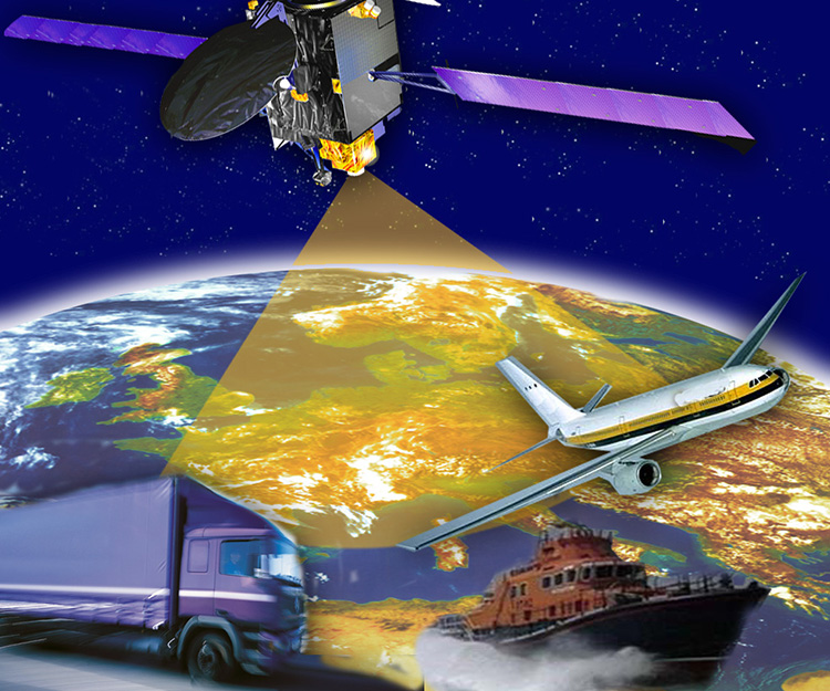
Satellite augmentation systems combine additional ground stations and satellite transponders to sharpen satnav accuracy and reliability across given geographical regions — based on the U.S. GPS for now, but with plans to move to a multi-constellation design additionally employing Europe’s Galileo, China’s BeiDou, and Russia’s GLONASS systems in the post-2020 era.
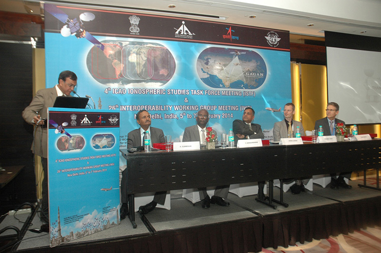
The 26th Satellite Based Augmentation Systems (SBAS) Interoperability Working Group (IWG) took place in New Delhi, India on February 5–7.
The 26th SBAS Interoperability Working Group (IWG) was introduced by V. Somasundaram, board member of the Airport Authority of India.
Among its achievements was to converge on a standard message definition for one of the channels — known as L5 — of the planned second-generation SBAS systems, which will utilize dual-frequency, multi-constellation signals.
“Two solutions had been put forward, one by ESA based on work by European industry and one from the U.S. Federal Aviation Administration and Stanford University,” explains ESA’s Didier Flament, co-chair of the IWG.
“A single definition coordinated between both bodies has been presented, combining the benefits of both solutions. The formal IWG review and approval loop has now been started with the objective of finalizing it for September’s IWG meeting.
“The aim is to have it ready to submit to the official international SBAS standardization bodies — the International Civil Aviation Organization and the Radio Technical Commission for Aeronautics — as soon as October.”
The meeting also marked the significant progress made by Indian’s own SBAS system GAGAN, which underwent its final stability test last summer, followed by its safety certification in December.
At this point GAGAN was declared certified for non-precision approach users , followed by its safety-of-life service being formally offered to civil aviation users on 14 February.
GAGAN has been jointly undertaken by the AAI and the Indian Space Research Organisation, intended to provide improved accuracy, availability and integrity necessary to enable users to rely on satnav signals for all phases of flight – from en route as well as approach to all qualified airports within the GAGAN service area.
SBAS services worldwide
EGNOS is an operational precursor to Europe’s Galileo global satnav system.
GAGAN is the fourth certified SBAS to enter servicer worldwide. Europe has the European Geostationary Navigation Overlay Service (EGNOS), which was designed and built by ESA then turned over for operation by the European Satellite Service Provider, ESSP, overseen by the European Global Navigation Satellite System Agency (GSA) — both of whom also participated in the meeting. ESA retains responsibility for the future evolution of EGNOS.
The U.S. has the Wide Area Augmentation System (WAAS), developed and operated by the Federal Aviation Administration, with an extension over Canada called CWAAS (Canadian WAAS). WAAS celebrated its 10th anniversary of operational life last July.
Japan has the Multi-functional Satellite Augmentation System (MSAS), developed and operated by Japan’s Civil Aviation Bureau. Japan is currently discussing plans to merge this capability with their new home-grown satnav system, QZSS.
Along with GAGAN, the meeting also covered the progress made by the other SBAS systems under definition or development — the Russian SDCM, Chinese SNAS and Korean K-SBAS.
The follow-up IWG meeting is due to take place in September in Tampa, Florida.
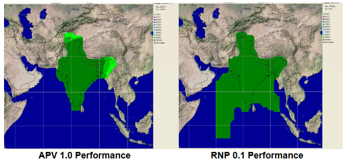
Planned GAGAN service coverage for the two different service levels (RNP0.1 and APV1). GAGAN has been jointly undertaken by the Airport Authority of India and the Indian Space Research Organization, ISRO, to achieve smooth transition to satellite-based navigation and seamless air traffic management across continents. GAGAN is designed to provide improved accuracy, availability and integrity necessary to enable users to rely on GPS for all phases of flight, from en route through approach for all qualified airports within the GAGAN service volume. More precisely it is aimed to provide Non Precision Approach RNP0.1 service levels to the entire Indian Flight Information Region and Precision Approach APV1 service (equivalent to the current EGNOS Service) within a specified service volume within Indian land mass.
Tackling ionospheric interference
The New Delhi IWG took place concurrently with a related meeting, the ICAO’s 4th Ionospheric Study Task Force. This group has been tasked with the objective of developing region-specific models of ionospheric models to compensate for satnav signal interference or loss.
The ionosphere, the electrically sensitive outer shell of Earth’s atmosphere, can be perturbed by solar activity. And because satnav signals pass from space by Earth they can then be disrupted in turn. Equatorial regions see the greatest disturbance, including signal delay or ‘scintillations’ making signals unstable.
The aim is to develop reliable ionospheric models to compensate for these effects, particularly for equatorial SBAS regions, such as India. ESA is contributing with data from its worldwide Monitor network, gathering data to improve future EGNOS performance and potentially support further geographical extension.
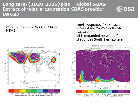
Comparing current worldwide SBAS coverage — based on WAAS, EGNOS and MSAS — to the situation envisaged for 2020–25: near-global coverage based on WAAS, EGNOS, MAAS, SDCM and GAGAN, with an expanded network of stations in the southern hemisphere, based on a common dual-frequency/dual satnav standard being finalized by the SBAS IWG.
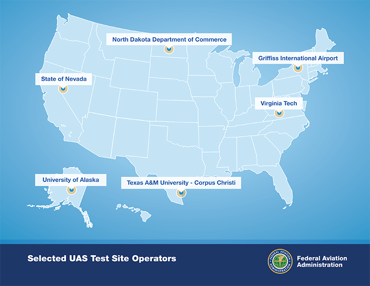
After a rigorous 10-month selection process involving 25 proposals from 24 states, the Federal Aviation Administration announced it has chosen six unmanned aircraft systems (UAS) research and test site operators across the country.
According to the announcement, in selecting the six test site operators, the FAA considered geography, climate, location of ground infrastructure, research needs, airspace use, safety, aviation experience and risk. In totality, these six test applications achieve cross-country geographic and climatic diversity and help the FAA meet its UAS research needs.
A brief description of the six test site operators and the research they will conduct into future UAS use are below:
University of Alaska. The University of Alaska proposal contained a diverse set of test site range locations in seven climatic zones as well as geographic diversity with test site range locations in Hawaii and Oregon. The research plan includes the development of a set of standards for unmanned aircraft categories, state monitoring and navigation. Alaska also plans to work on safety standards for UAS operations.
State of Nevada. Nevada’s project objectives concentrate on UAS standards and operations as well as operator standards and certification requirements. The applicant’s research will also include a concentrated look at how air traffic control procedures will evolve with the introduction of UAS into the civil environment and how these aircraft will be integrated with NextGen. Nevada’s selection contributes to geographic and climatic diversity.
New York’s Griffiss International Airport. Griffiss International plans to work on developing test and evaluation as well as verification and validation processes under FAA safety oversight. The applicant also plans to focus its research on sense and avoid capabilities for UAS and its sites will aid in researching the complexities of integrating UAS into the congested, northeast airspace.
North Dakota Department of Commerce. North Dakota plans to develop UAS airworthiness essential data and validate high reliability link technology. This applicant will also conduct human factors research. North Dakota’s application was the only one to offer a test range in the Temperate (continental) climate zone and included a variety of different airspace which will benefit multiple users.
Texas A&M University – Corpus Christi. Texas A&M plans to develop system safety requirements for UAS vehicles and operations with a goal of protocols and procedures for airworthiness testing. The selection of Texas A&M contributes to geographic and climactic diversity.
Virginia Polytechnic Institute and State University (Virginia Tech). Virginia Tech plans to conduct UAS failure mode testing and identify and evaluate operational and technical risks areas. This proposal includes test site range locations in both Virginia and New Jersey.
Across the six applicants, the FAA is confident that the agency’s research goals of System Safety & Data Gathering, Aircraft Certification, Command & Control Link Issues, Control Station Layout & Certification, Ground & Airborne Sense & Avoid, and Environmental Impacts will be met.
Each test site operator will manage the test site in a way that will give access to parties interested in using the site. The FAA’s role is to ensure each operator sets up a safe testing environment and to provide oversight that guarantees each site operates under strict safety standards.
From the start, the FAA recognized it was important to have requirements ensuring that privacy and civil liberties are protected at the test sites. Among other requirements, test site operators must comply with federal, state, and other laws protecting an individual’s right to privacy, have publicly available privacy policies and a written plan for data use and retention, and conduct an annual review of privacy practices that allows for public comment.
Under the current law, test site operations will continue until at least February 13, 2017.
Highly precise and free for use by anyone with an inexpensive receiver, GPS and other GNSS are great. Their navigation and timing signals have been incorporated into nearly every aspect of modern life, from synchronizing power grids to financial systems, the Internet, telecommunications, and transportation. The U.S. Department of Homeland Security estimates that these signals are used by all 16 of U.S. critical national infrastructure sectors, and are essential to the functioning of 11.
Jamming Threat Growing. When these faint signals can’t be received, people start to feel the impact immediately. Usually outages have minimal impact because they are localized and short-lived. Often they occur because the user is temporarily in an area without a good view of the sky. More and more often, though, they are due to the presence of one of a growing number of people with jamming devices (many of which also block cell phone frequencies).
Inexpensive, easy to obtain, and illegal, jammers are spreading as people become more concerned about privacy and being tracked by their employer, spouse, the National Security Agency, and others. Although the government tries to collect information on jamming incidents, no widespread detection system has been established, and few verbal reports are received. For the calls that do come in, it is often impossible to determine which are because of user error and which are purposeful interference.
For those cases where jamming is discovered, locating and identifying the perpetrator is difficult and often impossible. As one example, in spite of near-daily disruption of GPS that caused the shutdown of a new landing system at Newark International Airport, it took the Federal Aviation Administration and the Federal Communications Commission more than two years of concerted effort to identify the single perpetrator.
If a navigation satellite outage became widespread and lasted more than a few hours because of a major solar flare, software problem, hacker or cyber-attack, most authorities agree that the impacts would be catastrophic. While much of the information is classified, we do know that transportation would immediately become much less efficient and more dangerous; even many traffic lights are coordinated using satellite timing. Telecommunications, financial, energy and other systems would soon begin to fail as their back-up timing systems lost synchronization with each other. Power grids would lose synchronizations and outages may occur as transmission points became overloaded.
More than speculation, these problems have been documented in academic papers, proven in government tests in the United States and the United Kingdom, and the early stages of such impacts have been observed in localized and short-term outages in the United States. Most dramatically, they have been demonstrated by North Korea’s intentional jamming of South Korea.
Spoofing. Of equal concern is the problem of spoofing. The world’s preeminent ethical spoofer of satellite navigation receivers, Todd Humphreys of the University of Texas, Austin, has demonstrated how easy it is to take control of unmanned aircraft and ships on autopilot by sending a slightly stronger navigation signal, making the receiver think it is somewhere other than where it is. Iran claims to have done something similar, capturing a U.S. military drone in 2010. Humphreys has also shown (on paper) how time-stamps on automated financial transactions could be altered through spoofing. This could do things like reverse the buy-sell equation at a stock exchange, allowing someone to sell at a higher price before buying at a lower one.
The Government Solution
What is to be done? The challenges have been extensively documented and discussed since at least the 1990s. In 2004, President Bush issued the National Space Policy (NSPD-39) that addressed the problem. Although portions of it are still classified, contained within the publically releasable section was direction for the U.S. Department of Transportation (DOT) to, in coordination with the Department Homeland Security (DHS): “develop, acquire, operate, and maintain backup position, navigation, and timing capabilities that can support critical transportation, homeland security, and other critical civil and commercial infrastructure applications within the United States, in the event of a disruption of … space-based positioning, navigation, and timing services.”
eLoran Recommended. In response, the two departments consulted numerous experts and commissioned a study by the Institute for Defense Analysis (IDA) to determine what system or systems should be procured. The IDA study team, which included Brad Parkinson, widely recognized as the father of GPS, unanimously recommended that an existing and outdated nation-wide navigation system called Loran-C be greatly updated and modernized to eLoran. Such a system would provide a navigation and timing signal comparable with and complementary to GPS. They concluded that:
“eLoran is the only cost-effective backup for national needs; it is completely interoperable with and independent of GPS, with different propagation and failure mechanisms, plus significantly superior robustness to radio frequency interference and jamming. It is a seamless backup, and its use will deter threats to US national and economic security by disrupting (jamming) GPS reception.”
What the IDA did not find, but that has since become evident, is that establishing an eLoran system could be an important part of a network to identify and locate jamming attempts. Since all eLoran transmitters would be synchronized with GPS, and many navigation receivers would have both GPS and eLoran sensors, differences between the two systems could be immediately detected and reported.
The body in charge of coordinating navigation and timing issues for the federal government is the National Space-Based Position Navigation and Timing Executive Committee (NPEC). It is chaired by the Deputy Secretaries of Transportation and Defense. Responding to early briefings on the IDA report (which was not formally published until 2009), the Departments of Transportation and Homeland Security in 2007 told the NPEC that they had decided eLoran was the right answer. After further federal deliberations over how to create an eLoran system, 2008 saw:
A press release by DHS saying that the department would implement eLoran, using the old Loran-C infrastructure (February 7, 2008)
The DHS 2009 Budget in Brief (February 2008) propose transferring legacy Loran-C systems and $34.5 million/year from Coast Guard to the National Protection & Programs Directorate (NPPD) within DHS, stating:
“The FY 2009 budget transfers the budget authority for the LORAN C system from the United Sates Coast Guard to the NPPD. The Department, acting as Executive Agent, will begin development of enhanced eLORAN as a backup for GPS in the homeland.”
The National PNT Executive Committee endorse the above decisions (March 2008).
Failure to Launch
Unfortunately, DHS funding for 2009 came as part of a continuing resolution, and the Congress did not see fit to approve the transfer of funds from Coast Guard to NPPD.
This was because influential members of Congress wanted the nation to have eLoran, but were concerned about the lack of a plan for transition of this important capability from one agency to another. The administration was asked to develop and submit a plan with with the next budget cycle. A year later, though, no plan had been presented, and the President’s request (and enacted legislation) for 2010 contained no request to move and upgrade the system. In fact, it contained provisions for shutting down and defunding the old Loran-C system without providing funds for NPPD or any other agency to establish the new eLoran capability.
No Solution at All. What happened between one budget year and the next to take the nation from “solution-in-hand” to “no solution at all” is not a matter of public record. Internal administration budget deliberations are not generally released to the public. It does appear, though, that a new administration putting together its first real budget quite rightly wanted to shut down an antiquated system, but did not understand the importance of a new one. This, and many other factors, unquestionably played a role.
Movement Backward
Without any funding, DHS has since conducted several studies and experiments, but has done very little of substance to address this critical infrastructure issue. While Department of Defense (DOD) officials talk about the need for resilience, experts throughout government and industry decry the lack of action, and the Department of Transportation still has acquiring “backup position, navigation, and timing capabilities” on its to-do list, none have seen fit to move forward on their own.
Felling Towers. Worse, DHS is actually reducing the nation’s ability to create eLoran and a wide-area interference detection and mitigation system. An ongoing effort to fell towers and dispose of equipment from the legacy Loran-C system will significantly increase the cost and time-to-operation of the new system the nation needs.
The Way Forward
Fortunately, awareness and understanding of the problem within government, and the general public has continued to grow.
The U.S. National Space-Based Positioning, Navigation, and Timing (PNT) Advisory Board published a seminal white paper in 2010 on the topic, strongly recommending the establishment of an eLoran system. Todd Humphreys, the UK navigation authority, and others have provided numerous graphic demonstrations of the folly of relying upon just one electronic navigation system, and how things can go horribly wrong. Some of these have been well publicized. Other incidents are known only to a few.
There are also signs that the U.S. intelligence, cyber, and defense communities are becoming more and more concerned. North Korea’s repeated jamming of satellite navigation and timing signals has delivered a particularly powerful lesson. South Korea has reacted by committing to establishment of a robust eLoran system. The UK has established an eLoran system and is expanding it. Russia and China have retained their versions of Loran-C and are using it to augment satellite services. Russia has announced it will upgrade its system to eLoran in cooperation with the UK, and China may not be far behind. Saudi Arabia is upgrading its system to eLoran, and India has plans for an eLoran network in the near future. In December, Iran announced it has established a land-based system with “powerful transmitters” that is “completely different with GPS.”
Allies, adversaries, and economic competitors are augmenting satellite services with strong terrestrial ones. The United States will soon be one of only a small number of major economies that does not have a strong, difficult-to-disrupt terrestrial system protecting its critical infrastructure and providing value-added utilities. DOD’s chief information officer expressed interest in eLoran as part of DOD’s pivot to the Pacific. But providing a system at home is not in Defense’s job description, nor should it be.
Respected leaders at the Departments of Transportation and Homeland Security still see this as an important issue that needs to be addressed. The question for them now is not one of technology. The technology decision made in 2008 has since been revalidated by a plethora of academic papers, risk estimates, and white papers. eLoran still appears to be the most effective and least expensive solution available. DOT and DHS must resolve questions of governance and how to fund the system in one of the most difficult federal budgetary climates in decades.
How? The answer could lie in a public-private partnership (P3). In such an arrangement, the government would bring its interests and the infrastructure it owns to the table. An entity in the non-profit sector or industry would provide investment to refurbish the infrastructure, stand up, and operate the system. Such a P3 enterprise could not only pay for itself, but be an on-going source of revenue for both the government and the private entity.
The Business Model: Demand
A well-configured eLoran system can provide navigation accuracy to within 8 to 10 meters and timing accuracy to within 30 nanoseconds. This meets the needs of an estimated 95 percent of users in the United States. While eLoran does not offer the sub-meter precision of a high end, augmented GPS/GNSS system, it has its own advantages. In addition to being very difficult to disrupt, its high-power (typically 400 kW transmitters), low-frequency (100 kHz) signal easily penetrates and is usable underground, inside buildings, and underwater — where satellite and cell phone signals on much higher frequencies cannot reach.
The UK experience with eLoran and private surveys in the United States have shown high commercial demand for a ubiquitous, wireless, precise, and resilient time and navigation service. Power companies want to synchronize grids with a signal that can’t be disrupted by a delivery driver trying to avoid being tracked by his boss. Cell phone companies would be happy to have alternative timing capability in their networks, provided through inexpensive eLoran receivers. Operators of autonomous vehicles want a robust navigation signal and guaranteed communications. And it would be welcomed by the many users who, research shows, rely upon GPS/GNSS time for mission-critical applications, and who have no secondary source on which to fall back in the event of a disruption.
Since eLoran easily penetrates inside buildings, underground, and underwater, it can be used for timing and navigation in many places where no other navigation and timing sources are available. For example, it has been used for underground and underwater navigation. When paired with an accurate satellite signal before going underground or submerging, eLoran could enable a navigation receiver to maintain a comparable level of precision for several hours. Even after that, it would provide the navigator an accurate underground/underwater compass, and a good position.
The eLoran navigation and timing system now in operation in the United Kingdom also generates revenue by transmitting data. While the full potential of this third-party data-channel capability is still being explored, the ability to assure data delivery to, and communicate with such areas is appealing to many commercial and government organizations. Potential first-responders and commercial benefits appear almost limitless.
The Business Model: Costs
The cost for the P3 to standup and operate an eLoran system in the United States would be exceptionally low. Most of the needed infrastructure is already owned by the federal government in the form of the sites for the shuttered Loran-C system. Many of these still have transmission towers and other equipment that could be repurposed. Re-using this infrastructure and equipment would greatly reduce both the time and expense needed, compared to standing up the new system from scratch.
Operating and maintenance costs would also be low. Solid-state equipment, remote monitoring, and other advances in technology make the process of re-establishing a transmission site fairly inexpensive. Today’s eLoran transmitting site consists of a tower, an equipment enclosure for the transmitter, a fence, and a backup generator. With only a modest investment to refurbish existing infrastructure, regular outlays to service capital debt would be minimal, at best.
Some estimates predict that a terrestrial precise navigation and timing system, such as the one established in the United Kingdom and the one up for contract by South Korea, could be established in the continental United States within three years and for approximately $40 million, if the existing infrastructure were repurposed. Operating costs are estimated at approximately $16 million per year.
Business Model: Revenues
Significant national and homeland security concerns, high demand, and low cost (especially compared to any government space program) — clearly, but for a series of unfortunate bureaucratic reasons, eLoran would have been established in the United States, probably as a government-owned and operated system, long ago.
But high demand and low cost are also excellent ingredients for a business enterprise, provided there are sources of revenue. An eLoran P3 could have multiple sources of revenue. Depending upon the type of partnership and business model(s) the government selected, surplus revenue could also be generated to help fund other programs or offset the deficit. Some of the possibilities include:
◾ Guaranteed Delivery Data Transmission. As mentioned earlier, eLoran’s high power and low frequency mean that the signal penetrates where few others will. In addition to navigation and timing information, which are inherent in the basic signal, low-rate data can also be included between the primary pulses. The highest demonstrated data transfer rate to date has been 1300 bps, which is fine for texting and issuing commands. Many believe that, with a modicum of research, that rate can be much higher. As the owner of the high-power transmitter network, the P3 would generate revenue the same as any telecommunications provider: by charging per message or for time on the network.
Applications could include:
• Assured wireless control of remote equipment and vehicles, including indoors, underground and underwater;
• Information delivery to first responders and other crews regardless of location — especially good for pre-programmed emergency and operational commands to evacuate, use another procedure, and so on.
• Immediate device updates and reprogramming. The ability to reach all of the enabled devices on a given network at the speed of light and virtually simultaneously has unlimited potential.
◾ PNT Interference Detection and Monitoring. One of the biggest challenges to countering jamming satellite navigation and timing signals is the lack of a detection network. The eLoran transmitter and receiver network will continuously synchronize with GPS/GNSS signals and instantly detect when differences between the two dissimilar systems occur. Instant reports could be generated to inform federal, state, and local authorities of the anomalies and their locations. Mobile disruptors could even be tracked as they drove down the highway, sailed through the port, or flew across the sky. The P3 could generate revenue by contracting to provide such information to private parties and government agencies concerned about interference incidents.
◾ Licensing Receivers. One of the simplest ways to generate revenue and endow the P3 would be for the government to assess a small fee on every eLoran and satellite navigation receiver sold in the United States. A one dollar fee per unit could generate more than $20 million per year and fund operation of the entire system. Such a fee could be discontinued as other sources of revenue from the system made it unnecessary.
◾ Broad-based User Fees. Since navigation and timing signals are essential to so much U.S. critical infrastructure, a case could be made that the cost to endow the P3 should be spread as broadly as possible across the technologies it supports. For example, a temporary 8-cent fee on every monthly U.S. cell phone and electric bill for just one year could provide enough funding to endow the P3 in perpetuity.
◾ Value-Added Services For High-End Users. More than 90 percent of the users of precise time in the United States require it at the microsecond (1,000 nanoseconds) level of accuracy. eLoran can provide a signal accurate to 30 nanoseconds. To achieve that level of precision, the eLoran network transmits data that compensates for low-frequency signal propagation over non-homogenous terrain. This correction data could be encrypted. Most users would access the signal at the microsecond level of accuracy for free. Revenue could be generated by charging those who desire the higher level of precision a fee for the encrypted portion of the signal.
eLoran is an essential national and homeland security capability. The above list of potential revenue sources is just a sampling of the many ways a P3 could be funded. The point is that financing the enterprise need not come from tax dollars, and should not be an obstacle to its creation.
The Public-Private-Partnership
The U.S. government has had some great successes solving previously intractable problems through public-private-partnerships. Probably the best known of these are the P3s formed for housing on military bases. Establishing a business model that has private partners constructing and managing on-base housing produced more and higher quality housing for our troops.
Such arragnements must be carefully managed, however. Both the Congressional Budge Office and the Office of Management and Budget are understandably concerned that P3s may get a project going, but soon the costs may fall entirely on the government.
Success in any endeavor often depends upon its execution. The type of partnership the government selects and creates will be key. While, at its heart, a P3 is just a contract, the nature and provisions of government contracts are endlessly varied. Issues to address will include how the infrastructure is provided, if it is to be retained in perpetuity by the government or will be conveyed to the private party, what length of contract will allow the private partner to recoup its initial investment, and the business model(s) to be pursued.
The type of governance will also be important. Models vary from establishment of a self-funded government corporation to oversee daily operations, to an agency-supervised, performance-based contract that only requires regular reports on system availability and performance.
Of course, the concerns of CBO and OMB must be met. Fortunately, the federal government is not without experience with P3s. Also, there are many supporting resources available, such as the National Council for Public Private Partnerships.
We Have to Do It
Establishing a public-private partnership will bring together the best of both the government and the private sector. For its part, the government will bring the legacy infrastructure and its interest in safeguarding the public good to the table. The private sector will bring financing, technical know-how and innovation. A better system for America will result than would have been possible if either were to act alone.
It is unquestionably in our urgent national interest to address the problem now, before jamming becomes more widespread, or we have a larger, more damaging event. The need is clear. The technology exists and works great. All that remains is for dedicated leaders within government and the private sector to work together and implement the solution.
Dana A. Goward is the president and executive Director of the Resilient Navigation and Timing Foundation, a non-profit organization devoted to educating people about the need for and encouraging resilient navigation and timing ecosystems with services that complement each other and have different failure modes. See www.RNTFnd.org.
Explosive growth in the UAV market is the focus of a free GPS World webinar this Thursday. Most on-board navigation systems in UAVs — unmanned aerial vehicles (UAVs) — rely on GNSS or GNSS with inertial aiding.
As military budgets decline, interest in civilian commercial applications is growing rapidly. The FAA recently awarded special type certification to two UAVs for commercial Arctic operations, and the industry is now poised for the opening of the regulation floodgates to address a growing commercial demand.
In Thursday’s webcast, “Unmanned Aircraft Navigation,” participants will hear from industry leaders in GNSS-based navigation for UAVs, in both the military and civilian sectors: they will tell us what they are doing in UAV navigation and where they see this exciting market going.
The webinar will be held Thursday, November 21, 10 a.m. PST / 1 p.m. EST / 6 p.m. GMT. Registration is free.
Guest Speakers
Olivier Casabianca, Business Area Manager, Trimble GNSS OEM
Casabianca works on the Trimble GNSS OEM portfolio which includes both the Trimble and Ashtech receiver module product lines. He joined Trimble in 2011 with the Ashtech acquisition where he was driving the Ashtech GNSS Technology roadmap and OEM portfolio. He has worked in the GNSS industry since 1997 and has held various positions in Engineering (RTK, GNSS Heading and Attitude firmware engineer, program management, engineering manager) and Marketing. He is located in Nantes area of France.
Hal Adams, Chief Operating Officer, Accord Technology
Hal Adams is founder and Managing Director of AvValues LLC which partnered with Accord Software & Systems, Bangalore, India to form Accord Technology LLC of Phoenix, Arizona USA. Adams has more than 35 years of civil and military aerospace and avionics experience in the aerospace industry, including senior leadership positions in general management, product and business strategies, development activities with Northwest Airlines, Lockheed-Martin, Litton Aero Products (now Northrop Grumman), Rockwell Collins Avionics, Thales Avionics and Aviation Communications and Surveillance Systems (ACSS – an L-3 Communications and Thales Joint Venture). As a co-founder of Phoenix Aerospace Consulting Group, Adams’ oversight responsibility was leading the NexNav business area which provided the industry’s first certified GPS WAAS Beta-3 sensors to the commercial aviation marketplace.
Neil Gerein, Defense Product Manager, NovAtel
Neil Gerein joined NovAtel Inc. as a GPS Software Engineer in 2001. Since 2009 he has worked as the Defense Product Manager for NovAtel. He is responsible for the navigation warfare product lines, including the GAJT GPS Anti-Jam antenna and OEM625S SAASM receiver used in unmanned vehicle systems. He holds B.Sc. and M.Sc. degrees in Electrical Engineering from the University of Saskatchewan, where he specialized in digital signal processing. Neil currently serves on the Council of the Institute of Navigation, as well as on the executive of the Alberta regional section of the Institute of Navigation.
Eric Brewer, Senior Systems Engineer, Rockwell Collins
Eric develops and tests guidance, navigation, and control algorithms for unmanned and optionally piloted aircraft. He was a key contributor to Rockwell Collins’ damage tolerance program, which successfully recovered a sub-scale F18 after simulated battle damage ejecting more than 75% of the right wing. As lead systems engineer, Eric spearheaded the successful integration of SAASM RTK on the STUAS program. He received a B.S. in Mechanical Engineering from Penn State in 2008, and an M.S. in Mechanical Engineering specializing in autonomous rotorcraft from Virginia Tech in 2009. When he’s not programming away in MATLAB, Eric enjoys hiking, rock climbing, and testing the damage tolerance capabilities of R/C airplanes and helicopters.
Howard William Loewen, President, MicroPilot Inc.
Howard is the president of MicroPilot Inc. Howard has a degree in Electrical Engineering with an option in Computer Science and a Masters degree in Computer Science both from the University of Waterloo. Howard has been involved in the UAV industry since 1994 when he started MicroPilot. Under Howard’s leadership, MicroPilot was the first to introduce a single board, fully integrated UAV autopilot into the market, the first to introduce ultra lightweight autopilots, the first to introduce a triple redundant UAV autopilot among others. MicroPilot has continued this tradition of leadership with its recent introduction of XTENDERvalidate a requirements management tool designed specifically for UAV system integrators.
To fly a UAV in the U.S., you’d better be able to avoid any other aircraft — and ADS-B is one component of that capability. When the FAA and agencies around the world get their UAV regulations aligned with those levied on passenger-carrying aircraft, GNSS receivers on board UAVs will likely need to be qualified to equivalent standards. One company is already there.
When I was wandering around the show floor at the Association of Unmanned Vehicle Systems International (AUVSI) in Washington, D.C., in August, I got a pleasant surprise when I bumped into an old friend I knew from Calgary. Jayanta Ray was a grad student at the University of Calgary (U of C) when I was at NovAtel a few years ago. The students of the GNSS courses at U of C were often at local Calgary ION chapter meetings I organized or attended; there were also a few joint industry-university projects, and there were many, many discussions. So meeting Jayanta (Jay) at the Accord Systems/NexNav booth was a pleasant surprise, and it was good to renew our acquaintance.
This got me thinking that maybe some of that U of C receiver magic had somehow found its way through Jay into the airborne qualified receivers that Accord Technology is offering for UAVs. Jay is actually a member of the GPS World Advisory Board, and provides a great overview of what’s good and what’s different about airborne qualified receivers in this month’s issue of GPS World.
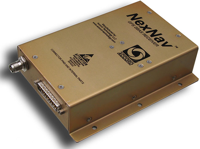
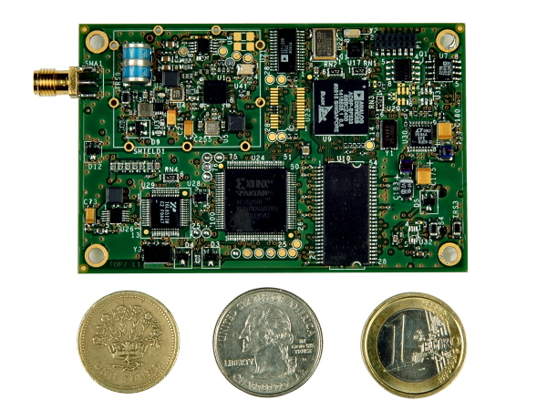
NexNav mini is also qualified for airborne GPS and ADS-B use.NexNav mini is also qualified for airborne GPS and ADS-B use.
Accord Technology is based in Phoenix, Arizona, and is the U.S. arm of Accord Software and Systems of Bangalore India, specializing in FAA-certified airborne versions of Accord’s GPS receivers.
At AUVSI, one of the hot topics was “Sense and Avoid” — if you are to fly a UAV in the U.S. National Airspace System (NAS), you’d better be able to avoid any other aircraft, and maybe also be able to tell other aircraft in the NAS where you are. ADS-B (Automatic Dependent Surveillance-Broadcast) is one component of that capability. ADS-B uses a network of ground stations that relay ADS-B transmissions from aircraft (called ADS-B Out) in the NAS to the Federal Aviation Administration (FAA) air-traffic management system, and the signal is also available to aircraft flying in the system if they are equipped to listen to the message (ADS-B In). Air Traffic Control (ATC) can then verify that you are where you are supposed to be, and your actual position shows up more readily on their tracking systems. Right now, ATC makes extensive use of radar tracking and aircraft transponder signals to track aircraft — ADS-B will be more efficient, less costly to maintain, and is capable of aircraft-to-aircraft position reporting. By 2020, it will be mandatory if flying within the U.S. NAS.
The other part of this story is that, eventually, when the FAA and other agencies around the world get their UAV certification regulations aligned with those levied on passenger-carrying aircraft, GNSS receivers on board UAVs will likely need to be qualified to equivalent airborne standards.
Accord has already done an enormous amount of work to qualify its NexNav receivers for both requirements, and was at the AUVSI conference to let the UAV community know that these receivers are available now. If you were developing a new UAV now, with a view to selling lots into the anticipated wide range of commercial applications, its certainly going to help your case with the certification authorities to install as much off-the-shelf certified avionics as you can. Accord already sells these receivers to a number of general aviation system manufacturers, and also supplies stand-alone ‘TSO’ed” receivers in enclosures for use on a number of aircraft types. When an airborne receiver is granted the TSO (Technical Standard Order) designation by the FAA, it recognizes that the receiver has been designed, built and qualified to stringent airborne technical requirements and is authorized by FAA for use on aircraft.
So how does a company with its HQ in India get to hold an FAA TSO for a GPS receiver? Well, other than taking years to develop the receiver in accordance with approved development standards, document the hardware and software design, and conduct test and verification activities, the company also proves to the FAA that the receiver meets the FAA-specified airborne GPS functional requirements. Loads of engineering work — and then you have to convince FAA that you did it all and did it right.
Accord in Bangalore actually teamed up with AvValues in Phoenix to form a joint venture known as Accord Technology (AT) to work the project together. Most of the original receiver development work was done in Bangalore, while AT in Phoenix became responsible as the design authority, and for production, certification activities, customer service, product support, and business development. Naturally, Accord in India still does ongoing engineering support and supplies receiver cards to AT under contract. The other twist to the story is that final assembly and test is carried out at the AT facility in Anchorage, Alaska, where the TSO was approved by the local FAA office.
But Accord isn’t only into airborne receivers. The company has been around since 1991 and has significant engineering resources (around 400 electronic and computer engineers) — with more than 700 man-years of GNSS R&D and production involvement. Here are some examples of the other GNSS products which Accord has in its technology/product inventory:
GPS L1 RF down-converter.
GPS RF & baseband.
GPS module.
GPS Spacecraft Positioning System (SPS).
Time-code generator.
SPS was developed for the Indian Space Research Organization (ISRO) and has been flown on all Indian low-Earth-orbit satellites, including IRS P4/5/6, TES, CartoSat, SRE and OceanSat.
IRNSS Reference Receiver.
The Reference Receiver is fielded in the ground-monitoring network for the Indian Regional Navigation Satellite System (IRNSS), which may mean that the ground network is using at least dual-redundant reference data, as NovAtel has also provided a similar receiver for IRNSS. Accord is also working on IRNSS user receivers.
Other receivers include high-dynamic GPS-GLONASS receivers, GPS/GLONASS/Gagan SBAS receivers, an internal GPS/GLONASS/Gagan simulator, and a handheld GPS/Gagan receiver with integrated three-axis compass and pressure altitude sensor — the latter used by a number of paramilitary forces.
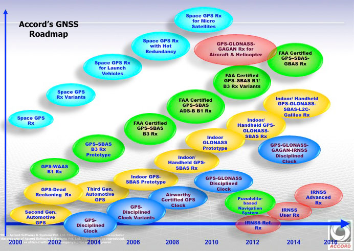
Accord GNSS roamap.
And as can be seen from the Accord GNSS Roadmap, they aren’t done yet!
You might ask yourself, where in the heck did all this come from? Certainly, there is an element of internal support with work for ISRO and Indian forces, but you don’t jump into this without some background. Well, the principle activity for Accord has been and still remains high-integrity software development for avionics systems — this is probably what Accord is known for in Europe and to a certain extent in North America. Its customer list for RTCA DO-178B/C airborne software sounds like a who’s who of aircraft and helicopter manufacturers — including Airbus, Boeing, Mitsubishi, Gulfstream Eurocopter/AugustaWestland/NHIndustries, Sikorsky, and Hindustan Aeronautics Limited (HAL).
Accord’s activities have included complete and partial life-cycle activities — all the way from requirements definition, software design and development, to independent verification and validation. For those of us who’ve worked in this field, we recognize that these are considerable technical capabilities — indeed, more than 50 engineers at Accord have been trained in the art of airborne software development by FAA-qualified engineering representatives. Working in this area and successfully bringing avionics systems through the qualification/certification process, companies either become capable or break all their bones trying! Clearly, Accord has been schooled in systems that are at the forefront of avionics technology, and has passed through the practical fire of qualifying airborne systems successfully.
So, it’s not really surprising that Accord went on to spin off into airborne GNSS receiver development once it gained wide visibility and knowledge of aviation technology and began to look at related markets. And with the Indian government policy of developing indigenous industries, Accord likely had some internal Indian customers. Quite a number of parallels with the way Europe has encouraged its own GNSS industry through the Galileo program.
With several avionics OEM manufacturers already using embedded NexNav TSO certified receivers in their systems using incorporating licensed designs, Accord looks well positioned to continue its airborne market growth. Accord’s success has so far been in general aviation, but it has wider aspirations, which include commercial transport aircraft (airline aircraft) — this is a segment which has the highest level of development/certification scrutiny and is therefore the most expensive segment in which to compete. Let’s hope Accord continues its growth and there is room in an expanding market for these relative newcomers.
NovAtel, an OEM provider of high-precision GNSS positioning products, has been contracted by the Federal Aviation Administration (FAA) to produce and deliver 176 Wide Area Augmentation System (WAAS) third-generation reference receivers (G-III).
The contract includes engineering support for the receiver as well as support for the current generation reference receiver (G-II), Geostationary Earth Orbit Uplink Subsystem – Type 1 (GUST) receiver, and Signal Generator (SIGGEN).
The third-generation WAAS program is a technology refresh of the highly successful, currently operating second generation WAAS Satellite-Based Augmentation System (SBAS). WAAS provides integrity monitoring, correction data, and increased satellite availability to users of GPS within its coverage area. The integrity monitoring features of the WAAS allow the use of GPS L1 C/A for safety-of-life applications and in particular for the civil aviation industry. The third-generation WAAS will monitor and augment the modernized GPS L5 signal, allowing aviation receivers to operate in two protected aviation frequency bands with assured integrity.
NovAtel’s WAAS G-II receiver.
NovAtel’s reference receivers and uplink station equipment have been a central element of the WAAS since its inception. The G-III reference receiver uses fully updated hardware and tracks all GPS signals including the legacy GPS L1 C/A, L2P(Y) (semi-codeless), and the modernized L2C, L5, L1C signals as well as the WAAS L1 C/A and L5 signals.
The WAAS G-III reference receiver provides a rich set of range measurement data, signal integrity metrics, and logs for processing by the system’s data communication processor. The receiver architecture is designed to facilitate future expansion and reconfiguration to support the evolving needs of WAAS and other SBAS systems worldwide, including multi-constellation augmentation systems.
“We have a long relationship with the FAA and have worked very closely with the WAAS program team to develop a third-generation ground reference receiver that carries over the pedigree of our first and second generation products, while adding features and processing capacity required for the modernized system,” said Jason Hamilton, director of marketing for NovAtel. “The WAAS G-III was designed and tested specifically for ground reference networks requiring reliable continuous operation, high-longevity components, and DO-178B design assurance.”
Accord Technology, maker of NexNav products, is debuting its capabilities for enabling fully FAA compliant GPS for Detect and Avoid at the AUVSI Unmanned Systems annual convention, being held in Washington D.C. August 12-15.
Known for its certified, U.S. FAA ADS-B fully compliant GPS WAAS/SBAS sensors and receivers for NextGen solutions in the airline, business and general aviation industries, NexNav products include OEM circuit-card assembly receivers the size of a credit card as well as line replaceable sensor units.
This is the company’s first time exhibiting at the AUVSI conference.
“We are excited to be exhibiting at this show and I believe our NexNav products will fill a niche that the unmanned aircraft need,” commented Hal Adams, Chief Operating Officer for Accord Technology, LLC. “Our NexNav product already meets FAA requirements and us currently flying on many manned platforms as well as on EU UAS platforms now. I look forward to talking with attendees about the Detect and Avoid GPS solution NexNav can provide them.”
Accord Technology received TSO-C145c for its NexNav mini in 2010, and fully qualified as GPS source per the U.S. FAA ADS-B Advisory Circular 20-165. The NexNav mini GPS technology was the first GPS WAAS sensor to be authorized U.S. FAA TSO-C145c WAAS Class Beta-1 ONLY. It is a market-breaking hybrid of automotive technology and aviation requirements providing an affordable solution for ADS-B GPS source, Accord said.