France has begun the Synchrocube project with an aim to provide a complementary service to GNSS. In the project, a low-Earth-orbit nanosatellite will provide synchronization functions when GNSS navigation signals are unusable.
Development of the Synchrocube is part of the French recovery plan for the space sector. Planned to be 6U in size (typically 20 × 10 × 34.05 cm), the satellite platform is being developed by Syrlinks, which will provide both the payload and the ground receiver necessary to provide the location and timing service.
Consortium
Besides Syrlinks, companies taking part in the Synchrocube project include U-Space, (nanosatellite platform supplier), Anywaves (miniature antennas for satellites constellations) and Comat (satellite instruments).
By pooling their technologies, the companies in this consortium demonstrate their ability to provide effective and competitive solutions to respond to ambitious space programs.
“Synchrocube represents a major evolution for Syrlinks,” said Guy Richard, Syrlinks CEO. “The implementation of a project as sizeable as this opens up new commercial prospects for the company. Syrlinks, initially known as a satellite subsystem manufacturer, is on its way to becoming a service provider.”
The TopAXYZ inertial navigation unit by Thales. (Image: Thales)
Thales and CS Group partner to offer navies a cybersecure, jam-resistant navigation system inspired by civil aviation
Thales and CS Group have partnered to offer a complete navigation system for navy surface ships. At the heart of the system is the Thales TopAxyz inertial navigation unit, which is integrated with CS Group’s real-time computer to combine high-level performance and resilience in an electronic warfare environment. The system provides high-precision pointing, gyrocompass, location and navigation functionality for all types of naval platforms, from surface combatants and submarines to autonomous vehicles.
The TopAxyz inertial navigation unit has delivered outstanding performance in the rigorous conditions of civil aviation, clocking more than 20 million hours of operation. The naval version of the unit was integrated on a French Navy vessel in less than a day by CS Group, and has already proven its operational value for maritime navigation in a sea trial.
“After proving their value on board aircraft, space launchers and French Army land vehicles, Thales inertial navigation systems are now available for naval platforms,” said Tristan Grivel, vice president business development and sales for Thales’s flight avionics business.
“CS Group has supplied real-time navigation computers, military-grade GPS receivers and other solutions to the French Navy and Naval Group for many years, explained Gilles Rigal, director of CS GROUP’s naval systems business line. “This partnership with Thales allows us to offer an innovative, robust and resilient maritime inertial navigation system for surface ships,” Rigal said.
Countering electronic warfare
In today’s constantly changing naval environment, crews need to contend with the threat of cyberattacks, electronic warfare activity and the high risk of jamming and spoofing of GPS-based radionavigation solutions. Accurate navigation data, real-time data distribution and resistance to external threats are crucial for every mission conducted by a naval vessel today.
Thales and CS Group have worked together for more than 20 years to address these issues. Drawing on their combined expertise across all the key navigation system technologies, the two companies are now proposing a new approach to maritime navigation based on more trustworthy and reliable navigation data.
The TopAxyz inertial unit uses accurate, reliable navigation information that is independent of sea state and vessel location, combined with a function that detects attempts to spoof GPS signals. The navigation data calculated by TopAxyz is distributed in real time by the NDDS (Navigation Data Distribution System) developed by CS Group’s onboard computer.
The computer uses the latest technological advances in cybersecurity, guaranteeing the best level of resilience to attacks. Its architecture offers three key advantages: safer navigation, reduced costs and integration risks, ease of use and simplified maintenance of the system. No calibration is required during the service life of the system, reducing the total cost of ownership.
The new maritime navigation system are now available, and are being manufactured at the companies’ production and integration facilities in Châtellerault and Aix-en-Provence in France.
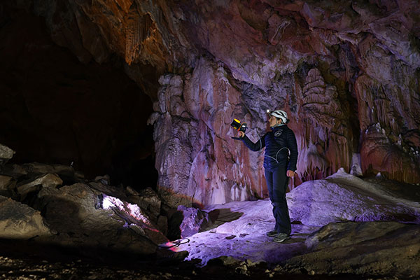
The versatility of the ZEB Horizon device enabled the Deep Time team to map the complex and challenging environment. (Photo: GeoSLAM)
Geospatial 3D mapping specialist GeoSLAM provided the technology to scan one of Europe’s largest caves as a part of the Deep Time isolation study.
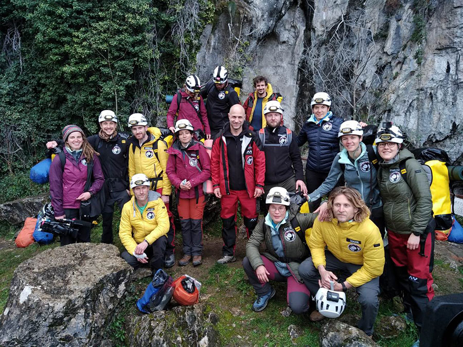
For 40 days, 15 participants set up camp in the Lombrives cave in southwestern France with no clocks or sunlight, and zero contact with the outside world. Conducted by the Human Adaptation Institute, the experiment aimed to explore the links between the human brain and time, in order to gain insight into the limits of human adaptability to isolation.
Throughout the mission, the “deeptimers” organized tasks to complete within the cave setting to help structure their days. Their first task was to conduct a recce of the location.
GeoSLAM technology was called upon to conduct a digital scan of the 3-km Lombrives cave — a cave system consisting of both narrow passages and expansive chambers up to 70 meters in height, formed more than 125 million years ago.
The handheld ZEB Horizon is put to the test by a Deep Time participant. (Photo: GeoSLAM)
The team used the lightweight ZEB Horizon device, which harnesses GeoSLAM’s unique SLAM (simultaneous localization and mapping) algorithm, putting to the test the device’s 100-m range capabilities. Its versatility and walk-and-scan method of data collection allowed the team the flexibility to crouch, crawl and scan the depths and narrow canals of the cave, including 90-m deep wells.
Traditional tripod-based systems used for digital mapping rely heavily on GPS to collect accurate data. SLAM technology however, overcomes this limitation by cutting out GPS altogether, enabling scans to be carried out in complex and enclosed spaces, including underground.
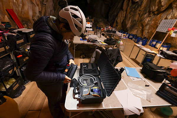
A Deep Time participant sets up GeoSLAM’s ZEB Horizon scanner. (Photo: GeoSLAM)
With low light levels, an ambient temperature of 10 degrees and humidity levels of 100 percent, the physical and psychological impacts the team experienced were documented on camera.
“We are thrilled to have been associated with the Human Adaption Institute on such an exciting and historic project,” said Tomas Blaha, GeoSLAM channel manager for Europe. “The handheld capabilities of the ZEB Horizon device provided easy-to-use technology for the members of the team with no professional surveying experience. The study tested the limits of human endurance in a challenging environment, and the same can be said of the technology to survey the Lombrives cave. Using traditional static and GPS-based scanners would have been impossible for this project, so we are delighted that the ZEB Horizon’s adaptability and ruggedness played its part in an historic piece of research.”
The 15 participants stand outside the Lombrives cave, France. (Photo: GeoSLAM)
A crucial step toward the development of the Galileo Public Regulated Service (PRS) military user segment took place Monday, Feb. 8, with the kick-off meeting in Brussels of the GEODE (GalilEO for EU DEfence) project, according to a press release from FDC.
GEODE is the biggest Galileo application development project ever launched.
Sponsored by Belgium, Germany, Italy, France and Spain — contributions should exceed 82.7 million euros — GEODE is supported by the EU with a grant of about 44 million euros. The ambitious defence-cooperation project is under the umbrella of the European Defence Industrial Development Programme (EDIDP) of the European Commission.
GEODE will establish the framework for developing the Galileo PRS user segment for defense applications. At kick-off, the project involved 30 companies and organizations from 14 EU Member States: Belgium, Czech Republic, Estonia, Finland, France, Germany, Greece, Italy, the Netherlands, Poland, Portugal, Spain, Sweden and Romania.
The GEODE Roadmap
National defense organizations — in close cooperation with industry — have defined a roadmap for the Galileo PRS military user segment development, beginning with a specification and standardization phase. GEODE will prototype, test and qualify
seven PRS security modules developed from various technologies
nine PRS receivers (including two server-based variants)
four GPS/Galileo PRS-compatible anti-jamming controlled radiation pattern antennas (CRPA).
A common and standardized test environment will be developed as well as a PRS infrastructure to ensure the availability of the security assets for operational testing.
Finally, military operational field testing will be organized on military platforms (naval, land and drones) and timing and synchronization systems in (at least) Belgium, Czech Republic, France, Germany, Greece and Romania.
A PRS solution for spacecraft will also be designed and prototyped.
Beyond paving the way for the equipment of EU Member States defense forces with Galileo PRS, the military user segment that is developed, tested and certified under GEODE is planned to be available for export to other countries that have the necessary PRS security agreements with the EU.
The GEODE project will be completed in 2026.
Plans are for GEODE to
boost EU competitiveness in the highly strategic domain of military positioning, timing and synchronization.
foster the equipment of EU Member States’ military forces with Galileo PRS capability, essential to reinforce their interoperability and autonomy.
facilitate access to complex security-certified technologies and make them affordable through means of standardization and by creating the necessary critical mass.
In brief, the project will bolster EU Member States’ military capability, create business opportunities for the EU industry in the field of military application of satellite navigation, and maximize the benefits of the Galileo programme by energizing the adoption of its PRS service in all EU Member States and beyond.
Background on GEODE
This project has received funding from the European Defence Industrial Development Programme (EDIDP) under grant agreement No 039.
The GEODE industrial consortium is led by FDC and comprises the major industry players of the field: Airbus Defence and Space, Antwerp Space, Cy4gate, Diehl Defence, Elettronica, Fraunhofer Institute for Integrated Circuits IIS, GMV Aerospace and Defense, Indra Sistemas, Safran Electronics and Defense, Leonardo, Siemens Aktiengesellshaft, Orolia, Tecnobit, Telespazio, Thales Alenia Space Italia, Thales AVS France, Thales SIX GTS France, accompanied with 12 other EU companies acting as subcontractors (c.f. picture hereafter).
The GEODE project is developed in the context of the European Radio-navigation Solution (EURAS) project of the Permanent Structure Cooperation (PESCO). The EURAS project aims at promoting the development of EU military positioning, navigation and timing) capabilities and future cooperation taking advantage of Galileo and the PRS.
GPS technology is doing far more than helping us navigate or receive accurate time. It is now being used to fight the spread of the global COVID-19 pandemic.
Global navigation satellite systems are being used to collect big data on travel and contact, but they are also being used in more unconventional ways: for example, quarantine enforcement and sanitation technology.
Read on to learn about a few recent developments in the world of GNSS/GPS that are bolstering the battle against the novel coronavirus.
Electronic monitoring enforces quarantine
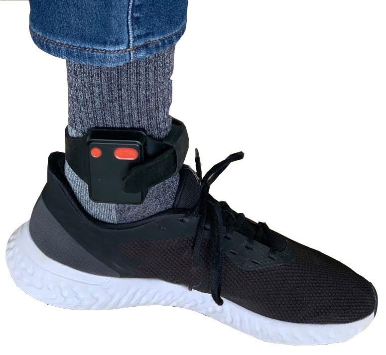
There is a surge of applying ankle monitors to track sick individuals and deter them from spreading the virus further. According to BloombergBusinessweek, one business is thriving because of it: providers of electronic ankle monitors.
Kentucky courts are requiring GPS ankle monitors for people who test positive for COVID-19 and refuse to self-quarantine. Kentucky couple Elizabeth and Isaiah Linscott were two of a growing number of people placed under house arrest after Elizabeth tested positive for COVID-19 and denied signing the Self-isolation and Controlled Movement Agreed Order, a health department document promising she would stay home.
Photo: Regulus Cyber
Elizabeth told Louisville television station WAVE 3 News that she did not sign because she disagreed with the wording of the document. She said that she was concerned about having to contact the health department before traveling, even in the case of an emergency.
“My part was if I have to go to the ER, if I have to go to the hospital, I’m not going to wait to get the approval to go,” she said.
A few days after Elizabeth refused to sign the paperwork, her husband opened their door to an entourage of law enforcement officers serving them with a Health Department order to wear ankle monitors.
“I open up the door, and there’s like eight different people, five different cars, and I’m like ‘what the heck’s going on?’ This guy’s in a suit with a mask. It’s the Health Department guy, and they have three papers for us. For me, her and my daughter,” Isaiah said.
The Linville family is now confined to a 200-foot radius. If they leave their designated quarantine area, their ankle monitors will alert law enforcement.
Alternative to prison
The number of people on house arrest in the United States and across the world has surged as corrections departments struggle to slow the spread of the coronavirus within prisons. An estimated 25 to 30 percent more people are wearing ankle monitors in comparison with a few months ago, according to Bloomberg Businessweek. The U.S. Federal Bureau of Prisons reported a 160 percent increase in home confinement from late March to July. European corrections departments have similarly put thousands of inmates on house arrest in the last few months.
“Demand has spiked everywhere,” BI Inc. monitoring equipment executive Robert Murnock said to Bloomberg. “We’re getting calls from different jurisdictions and other countries we’ve never worked with.”
Efforts to reduce crowding in prisons mean that the electronic monitoring industry is one of very few industries benefiting financially from the coronavirus pandemic.
“Coronavirus gives electronic monitoring companies an opportunity like they’ve never had before to expand,” parole reform expert James Kilgore said.
On Aug. 3, Singapore announced the rollout of electronic tracking devices to enforce quarantine. Travelers will be required to wear GPS and Bluetooth-powered tracking devices that notify authorities if quarantine is broken or the device is tampered with. The rule went into effect on Aug. 11 and applies to all incoming travelers — resident or nonresident — over the age of 12.
On Aug. 20, the premier of Western Australia, Mark McGowan , said his government could soon force people in hotel quarantine to wear electronic monitoring equipment if they are deemed a risk. “If we identify people who are potential flight risks or who might have a criminal history, we are looking at applying monitoring bracelets to them,” he said.
An estimated 25 percent to 30 percent more prisoners are wearing bracelets now compared to the pre-outbreak period. In the U.S., the Federal Bureau of Prisons has placed about 4,600 inmates in home confinement, a 160 percent increase since the end of March.
“Demand has spiked everywhere,” said Robert Murnock, vice president for partnership development at BI Inc., a provider of EM technology.
The emergency shift to electronic monitoring spurred by COVID-19 may foretell a long-term shift toward use as an alternative to prison time, reducing clutter and the risk of the virus spreading among inmates.
Photo: LeoPatrizi/E+/Getty Images
Contact tracing via mobile phones
Israel is using covert mobile phone data to track the spread of COVID-19. On July 1, the Knesset approved a bill temporarily reauthorizing mass surveillance of coronavirus-infected citizens by the Shin Bet, Israel’s internal security service. The original program lasted from mid-March to June 9.
The contact-tracing program works like this. When a patient is diagnosed with COVID-19, the Israeli Health Ministry provides their personal information — including their mobile number — to the Shin Bet. The Shin Bet then consults a classified database of every person who uses Israeli telecom services to determine who came into contact with the infected individual for more than 15 minutes at a time. After the Shin Bet sends information back to the Health Ministry, the Health Ministry notifies those people via text and tells them to self-quarantine.
The Shin Bet’s newfound role in public health enforcement is quite different from its usual focus. Former Shin Bet agents say the COVID-19 mobile phone tracking technology was originally developed as a counterterrorism measure, and the tracking system being used on Israeli civilians is almost identical to that used for suspected terrorists.
“It’s the same system, the same methods,” retired Shin Bet agent Arik Brabbing said to BBC. “We know that someone was here in the park. We can get from the [mobile phone] company all the details about the hour, the place, exactly the place… and we can understand who else was around.”
Supporters of the mass surveillance program, including Prime Minister Benjamin Netanyahu, argue that reduced privacy is necessary to curb the spread of the virus. However, the Israeli government has come under fire by opponents who claim that the program is intrusive and undemocratic.
Israel’s contact tracing procedures are more secretive than those of South Korea and Taiwan, other countries that mandate central mass surveillance. South Korea and Taiwan both enforce quarantines with mobile-phone tracking, and both have built publicly available COVID-19 data platforms.
The South Korean government has disseminated detailed — but anonymized — information about COVID-19 carriers, including their travel routes and treatment facilities. Citizens broadly support these measures — a testament to collectivism in Korean culture.
Civic engagement and enthusiasm for fighting the pandemic is also remarkable in Taiwan, where the public has been collaborating with the government on a town hall-style website called vTaiwan. Citizen-led initiatives, like a GPS-powered tool for tracking face mask supplies, have been applied nationwide.
Meanwhile in Europe, eight major telecom companies, including Vodafone and Orange, have been supplying anonymized metadata to the European Commission to model and predict the spread of the virus. In the United States, the Centers for Disease Control and Prevention is soliciting GPS data from mobile advertising companies rather than carriers themselves.
The two tech giants, Apple and Google, made it easier for health agencies to join its coronavirus exposure notification system, creating a new built-in app within iOS and Android. The app provides real-time notification to users when they are exposed to a sick person.
Virus-killing robots may roam the streets
GPS-based robots, drones and autonomous cars are being deployed to sanitize outdoor spaces, transport medical equipment, and announce safety information to the public.
Robots began rolling around the streets of Wuhan, the original epicenter of the coronavirus outbreak, as early as January. China was the first to deploy robots of this type, but India, Spain, France and other countries have followed in their footsteps. In addition to the chemical-spray approach, some companies are pioneering mobile disinfection robots armed with large ultraviolet-C germicidal lights.
Apollo, the autonomous vehicle company of multinational internet giant Baidu, has partnered with Chinese self-driving startup Neolix to transport food and supplies to Beijing Haidian Hospital. Every morning at 10:30 a.m, an unmanned car delivers meals to about 100 frontline workers. The process eliminates direct contact, protecting the safety of food service workers, hospital staff, and patients.
Zhangjiang Artificial Intelligence Island
A fleet of Apollo and Neolix’s unmanned cars is also responsible for disinfecting all roads on Zhangjiang Artificial Intelligence Island, an 100,000-square-meter industrial complex in Shanghai. The vehicles are loaded with up to 160 liters of spray disinfectant and can cover the island’s entire road system in about half an hour.
The vehicles at Zhangjiang AI double as nighttime surveillance bots. They patrol the island and make sure that guests are adhering to coronavirus protocols, alerting security personnel if they note suspicious activity.
In addition to using drones to spray disinfectant, South Korea’s government has leveraged the technology for public announcements. On July 4, 300 drones lit the sky above Seoul in a show of appreciation for frontline workers. The drones executed a 10-minute synchronized show that included images of face masks, hand washing, and social distancing.
Summary
As COVID-19 continues to ravage the globe, governments rely on GPS to track the virus, contain it, and fight against it. The battle against coronavirus is still being waged on a global scale, utilizing GPS as a weapon along with many other existing technologies.
The pandemic changed the world forever, and it also highlighted the power of tracking and monitoring location of people and machines. It is another testament to the immense reliance on GPS technology in our modern world.
The increased deployment of these technologies necessitates increased security measures, especially when public health is on the line. Regulus Cyber offers GPS Cybersecurity software. To read more about it, visit www.regulus.com.
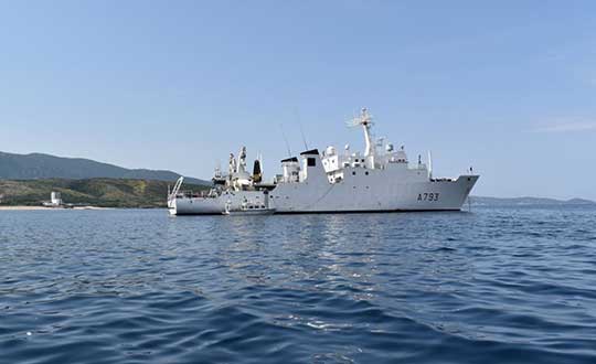
Shom, the French national hydrographic and oceanographic office, selected SBG Systems’ inertial navigation systems to renew its fleet.
The office chose the Navsight Apogee inertial navigation systems (INS) for its speedboats and survey vessels for both shallow and deep-water real-time bathymetric surveys and Qinertia PPK software for post-processing tasks.
As a public institution, Shom (Service hydrographique et océanographique de la marine) has three major objectives: national hydrography and cartography, defense support in hydro-oceanographic fields, and support in maritime geospatial products and services for public policies on the sea and the coast.
Shom’s fleet is based in Brest. It is composed of eleven boats, including seven speedboats, and three 59-meter long BH2 survey vessels. They operate on shallow and deep water in France, Africa, the Indian Ocean and in the Caribbean Sea. Shom also uses a fleet based in New Caledonia composed of two boats, one speedboat and a buoy-laying vessel used part of the time for hydrographic surveys.
French agency Shom’s survey vessel. (Photo: Shom)
Renewing the fleet. When it came to renewing the fleet’s INS, Shom looked at INS complying with standards set by the International Hydrographic Organization (IHO) for bathymetric surveys, with a focus on roll and heave that have the biggest impact on the multibeam echo-sounder data compensation.
After having conducted several tests in their official test zone where each element’s location is strictly and precisely known, Shom selected SBG Systems for replacement of its INS.
Shom first acquired a Navsight Ekinox (0.02° roll) for shallow-water survey in New Caledonia, and then decided to outfit the fleet in Brest with the Apogee (0.008° roll).
“The BH2 is highly versatile; it fits both deep and shallow water requirements. Having a homogenized fleet of sensors for speedboats and the BH2 is easier to maintain,” said Rémi Labonde, who is in charge of positioning and hydrographic equipment at Shom.
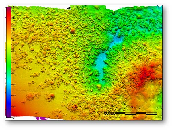
A seafloor survey conducted by Shom. (Image: Shom)
Navsight Apogee INS
Designed for hydrographers, the Navsight Apogee is composed of a GNSS receiver and a processing unit enabling real-time fusion of inertial and navigation data.
Navsight provides connections to external equipment such as echo sounders and computers. With its titanium enclosure, the Apogee sensor can be installed in the floodable engine compartment, close to the multibeam echo sounder.
Navsight marine solution. (Photo: SBG Systems)
Navsight Apogee is a high-performance cost-effective inertial navigation system based on state-of-the-art micro-electrical mechanical (MEMS) technology, and therefore requires no annual maintenance. The SBG solution includes free unlimited firmware updates and technical support.
Once connected through Ethernet, the Navsight web interface guides the installation. For example, a 3D view of the boat shows the entered parameters so that the user can check the installation in real-time.
The embedded filter also controls and validates lever arms and antenna alignment during this procedure, which can be a plus if the Shom needs to calibrate a new system abroad. “We are big fans of SBG’s web interface. It is modern, extremely clear, and easy to use; it really makes a difference in our team’s work,” Labonde said.
Qinertia post-processing software. Navsight Apogee INS accepts real-time corrections from real-time kinematic (RTK) or precise point positioning (PPP).
In its daily surveys, Shom uses PPP positioning, which doesn’t require installation compared to RTK. It also allows offshore surveying, or even near shore when no RTK correction is available.
SBG Systems’ in-house post-processing software Qinertia fixes data issues due to communication cut-outs. The onboard team checks the data and corrects it with Qinertia if needed.
ITSNT is an annual event organized by the French space agency CNES and Ecole Nationale de l’Aviation Civile for professionals and researchers working with or interested in navigation and timing technologies and their use.
The ITSNT preliminary program is now available, with experts discussing PNT resilience, multi-sensor navigation, autonomous/automated vehicles and much more. Also included are tutorials, exhibits and networking opportunities.
ITNST is an annual event organized by Centre National d’Etudes Spatiales (CNES) and Ecole Nationale de l’Aviation Civile (ENAC) for professionals and researchers working with or interested in navigation and timing technologies and their use.
The 2018 edition of the ITSNT will take place Nov. 13-16 in Toulouse, France, on the campus of ENAC.
This event is composed of two types of sessions:
Invited Guest sessions: special guests are invited by the scientific committee to give a presentation related to the generic topic of the session. Typically, there are four guest speakers per session, and the session ends with a round table. The programme of the “invited guest” sessions is available on the website.
Peer-Reviewed Paper sessions: the presenters of these sessions are selected by the scientific committee based on a call for abstract. The deadline for the call for abstracts is May 25. The final programme of these sessions will be available in October.
The ITSNT also provides a great environment for networking and visiting sponsors’ exhibition stands.
The symposium includes tutorials given by some of the invited guest speakers on their topic of excellence.
The International Technical Symposium on Navigation and Timing, also known as the ITSNT, is an annual event organized by Centre National d’Etudes Spatiales (CNES) and Ecole Nationale de l’Aviation Civile (ENAC) for professionals and researchers working with or interested in navigation and timing technologies and their use.
The 2018 edition of the ITSNT will take place Nov. 13-16 in Toulouse, France, on the campus of ENAC.
This event is composed of two types of sessions:
Invited Guest sessions: special guests are invited by the scientific committee to give a presentation related to the generic topic of the session. Typically, there are four guest speakers per session, and the session ends with a round table. The programme of the “invited guest” sessions is available on the website.
Peer-Reviewed Paper sessions: the presenters of these sessions are selected by the scientific committee based on a call for abstract. The deadline for the call for abstracts is May 25. The final programme of these sessions will be available in October.
The ITSNT also provides a great environment for networking and visiting sponsors’ exhibition stands.
The symposium includes tutorials given by some of the invited guest speakers on their topic of excellence.
NASA’s UTM. On May 25, the Federal Aviation Administration (FAA)-designated Nevada UAS Test Site and its NASA partners flew five different unmanned aerial vehicles (UAVs) to test NASA’s Unmanned Aircraft System Traffic Management (UTM).
The flights demonstrated multiple operational scenarios, including parachute-initiated emergency supply deliveries and aerial survey operations.
The UAVs were flown beyond the pilot’s visual line of sight (BVLOS) using strategically placed visual observers and sophisticated command and control, communication and detect-and-avoid technologies.
The test is part of a three-week national campaign, which NASA is leading in close collaboration with the FAA and industry partners on a more complex version of its UTM technologies at six different UAS Test Sites around the nation.
Demonstration in France. In France, Delair-Tech flew a UAV for 30 miles, simulating powerline inspection. Delair used a regular, commercial 3G cellphone network to control the drone for the test — an innovative demonstration that long-distance drone operations can be safe and simple to achieve.
Canadian Deliveries.Drone Delivery Canada Corp. (DDC) hit a pivotal milestone toward commercializing its drone logistics platform after achieving BVLOS in test flights. Systems tested include DDC’s FLYTE management system, avoidance technology and communications platform.
During flights in Alberta, DDC’s Mission Control Centre in Toronto, 2,500 kilometers away, successfully monitored and record telemetry in real time. DDC could become the first drone logistics-compliant operator approved by Transport Canada.
The Trimble VRS Now GNSS correction service is now available in France. The service is designed for a variety of geospatial and construction applications including surveying, cadastral, land administration, and urban and rural construction that would benefit from easy access to high-accuracy, centimeter-level positioning.
Trimble also now provides Galileo support for VRS Now. Powered by the Trimble Pivot Platform, VRS Now in Europe fully supports GPS, GLONASS, BeiDou, QZSS and the Galileo satellite system.
Galileo support improves network performance and reliability with access to additional satellites, particularly in urban canyons or other harsh environments. The increased number of visible satellites provides additional data observations that enhance positioning integrity to better mitigate errors.
“Trimble continues to aggressively expand its VRS Now footprint in Europe,” said Patricia Boothe, general manager of Trimble’s Advanced Positioning Division. “With the addition of correction services in France, Trimble VRS Now covers over 179 million square kilometers (732 million square miles) across 10 countries.”
VRS Now coverage is available throughout the majority of France as well as Belgium, The Czech Republic, Estonia, Germany, Great Britain, Ireland, Luxembourg, the Netherlands and Sweden using a compatible GNSS receiver or display.
Subscriptions are available through Trimble’s Authorized Business Partners or Trimble’s online store.
A region in France is working with SNCF (the French National Railway Company) to foster the emergence of new solutions — including GNSS technologies — for the operation and control of regional trains and railway infrastructure.
On Sept. 1, the Occitanie/Pyrénées-Méditerranée Region and GUIDE (GNSS Testing Laboratory) signed an agreement to open a railway line to field tests for companies seeking to perform assessments aboard trains. The agreement is supported by the French space agency CNES and the Aerospace Valley Center.
The Geofer project, managed by GUIDE, will allow the testing of applications in operational situations. The applications are based on radionavigation and telecommunication data initially intended for other business sectors.
Through the Geofer project, the Occitanie/Pyrénées-Méditerranée Region is pursuing two strategic goals. The first aims to strengthen mobility within the region through better control of operating costs. The second is to diversify industrial activities with rail. The project could lead to modernization of secondary lines of the national railway network by embedding, for example, some functions of railway signaling.
The test region — the Tessonnières-Rodez line (Tarn/Aveyron) — crosses a mountainous area conducive to tests in constrained environments.
As leader of the project, GUIDE is working to geo-reference the line and to instrument a train that will calibrate future embedded applications. The collected data will then be re-used and replayed on test benches to help solution developers tune their embedded systems more easily.
A co-financer of Geofer, CNES is actively involved in the tests. A receiver implementing an algorithm (PPP-WIZARD) developed by its engineers will be tested on board, using software to exploit future satellite services to achieve decimetric accuracy. This technology could make possible many rail applications such as precise dock stops or a better prediction of maintenance operations.
M3 Systems will supply the mission receiver responsible for dispatching accurate and real-time data about the positioning and speed of the train to embedded applications. This device merges the satellite measurements with those of other sensors used to ensure the quality of the geolocation messages.
For example, devices such as shock sensors to detect unusual efforts of the pantograph against the overhead cable, speed control systems for eco-driving, and roaming systems for telecommunication will be developed, implemented and evaluated on the line and on simulation benches.