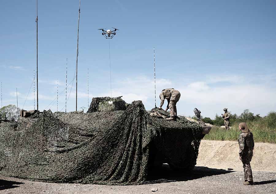
Elistair, manufacturer of tethered drones for security applications, participated in Orion 2026, France’s most ambitious joint military exercise in decades. In the exercise, Elistair contributed its Khronos automated tethered DroneBox, used for ISR and tactical communications missions.
Running from February to April, ORION 2026 mobilized up to 12,500 military personnel across the country in a high-intensity, multi-domain scenario involving land, sea, air, space, cyber and electromagnetic domains. More than 1,200 drones of all types were deployed throughout the exercise.
Elistair participated in Phase O4 (April 7–30) following its fisrt contribution during Phase O2 in February, which demonstrated France’s ability to fully integrate into a NATO command structure for collective defense scenario. During the week of April 27, forces conducted offensive exploitation operations, river crossings, retaking of key positions, and live-fire exercises.
The Khronos system
Forces need real-time situational awareness in contested and GNSS-denied environments. The Khronos system provides continuous aerial surveillance from fixed or mobile platforms. It does not depend on GNSS, radio frequency infrastructure, or battery-limited free-flying aircraft.
Khronos deploys from a transportable DroneBox in under two minutes. The system can deliver continuous day and night imagery for up to 24 hours, making it a “pocket watchtower” for tactical units.
The tethered drone operates in GPS- and RF-denied conditions through a secured tether and advanced positioning system. Elistair targets armed forces, law enforcement, civil security agencies, and private security operators in more than 70 countries. The company runs operations from France and North Carolina.
United Kingdom and French experts will work more closely to increase the resilience of both countries’ critical infrastructure to the signal jamming experienced in the war in Ukraine. The agreements are part of a suite of joint science and tech work.
The conflict in Ukraine has shown how new technologies — in some cases, small handheld devices — can be used to disrupt positioning, navigation and timing (PNT) services, potentially causing major disruption.
As part of a raft of UK-France joint science and tech efforts announced July 10, researchers from both countries will work together on technologies that complement GPS, which are highly resistant to this sort of jamming.
For instance, the e-LORAN program, driven by the UK government, is working closely with the National Physical Laboratory and private sector companies. The system uses ground-based radio towers, which are much more challenging to block, for a reliable “backup” to GPS, so that UK infrastructure can keep running even when GPS fails.
The UK’s Science and Tech Secretary Peter Kyle used a joint visit to Imperial College London, with French President Emmanuel Macron, to set out how such a collaboration makes both the UK and France stronger and safer. While speaking at Imperial, Kyle pointed out the tens of millions of pounds in investment being brought into the British tech sector through UK-French trade, as well as the new jobs and growth that this partnership creates.
These efforts will bolster the economic and national security of both countries, according to Kyle, which are foundational pillars of the Plan for Change.
The UK and France also are launching a partnership on supercomputing. The partnership will be led by the Bristol Centre for Supercomputing, the home of Isambard-AI, and the French computing centre GENCI, who lead France’s AI Factory.
Closer ties between both nations’ compute power and sharing AI best practice will turbocharge the breakthroughs in AI, transforming public services and improving lives, Kyle said. These efforts build on the AI Opportunities Action Plan, the UK government’s blueprint to fuel the use of AI across the economy. It builds on the strong existing UK-France cooperation on AI. The UK’s AI Security Institute and France’s INESIA have committed to further technical workshops to deepen their collaboration on frontier AI research to support national security.
Thales, a European leader in resilient navigation, announced a €55 million ($63 million) investment to expand its industrial sites in Châtellerault and Valence, France. The investment, scheduled between 2025 and 2028, aims to address increasing demand for advanced navigation solutions in both civilian and military sectors and to reinforce the company’s sovereign industrial base.
The company is responding to rising threats such as GNSS jamming and spoofing by deploying a suite of resilient navigation technologies. These solutions combine precision, autonomy and security, which are critical for maintaining operational continuity in military missions and civil aviation. Thales integrates inertial navigation systems with GNSS signal reception, enabling reliable navigation even in contested environments. The TopAxyz inertial navigation system ensures autonomous capability, while the TopStar-M receiver and TopShield anti-jamming technology protect signal integrity. These advancements are supported by France’s Directorate General of Armaments under the OMEGA program for the modernization of GNSS equipment for the armed forces.
At the Châtellerault site, Thales plans to quadruple production capacity for inertial navigation systems by 2028. With six decades of expertise in laser gyroscopes, this facility is the only European supplier equipping civil aircraft and will expand its offerings for aircraft, land vehicles, ships and munitions. In Valence, mass production of TopStar-M receivers and TopShield systems is set to begin in 2026. The site will also introduce a new production line for inertial MEMS sensors, a technology that combines compact design with high performance, positioning Valence as a leader in France’s MEMS technology sector for defense. The launch will be accelerated with support from Tronics Microsystems for specialized industrial expertise.
Currently, more than 800 employees work at the two sites, with plans to hire 150 additional staff by 2028. The investment seeks to strengthen Thales’ regional presence and contribute to France’s position in the industry.
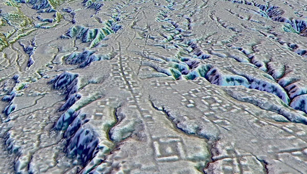
A lidar map of the city of Kunguints in the Ecuadorian Amazon reveals ancient streets lined with houses. (Image: Antoine Dorison and Stephen Rostain)
Archeologists have discovered a vast and highly complex system of ancient cities dating back nearly 3,000 years in the Amazon rainforest. Complete with a complex network of farmland and roads, the discovery is the oldest and largest of its kind in the region.
Located in Ecuador’s Upano Valley, the structures lie in the eastern foothills of the Andes mountains, according to a study published in the journal Science. After more than 20 years of research, the ancient urban centers were only discovered when the Ecuadorean government employed lidar technology.
“I have explored the site many times, but lidar gave me another view of the land,” archaeologist Stéphen Rostain, lead author of the study and director of research at the French National Center for Scientific Research (CNRS), told Live Science. “On foot, you have trees in the way, and it’s difficult to see what’s actually hidden there.”
A team of researchers from France, Germany, Ecuador and Puerto Rico conducted a lidar survey that covered roughly 300 km2. The survey revealed a landscape full of organized human activities, including more than 6,000 rectangular earthen platforms, as well as agricultural terraces and drainage systems.
According to the study, these structures formed at least 15 distinct settlements, which were connected by a system of wide, straight roads. Co-author Antoine Dorison, an archaeologist at the CNRS, said that this society’s complexity is especially evident in this web of streets, which were carefully constructed to cross at right angles rather than follow the landscape.
In recent years, lidar has been a vital tool for discovering traces of ancient civilizations. Lidar allows researchers to survey densely forested areas that are difficult to explore on foot and allows for the creation of accurate maps in a fraction of the time.
In August 2023, a team of researchers in a biological preserve in Mexico’s Campeche State used airborne lasers to cut through dense vegetation. This revealed ancient structures and human-modified landscapes beneath, including pyramids, palaces, and a ball court. The team was able to explore the dense area safely and identified the ancient Mayan city they discovered as Ocomtún.
NextNav has launched the first European commercial testbed for its high accuracy Pinnacle vertical location technology. Operating in Paris, France, the testbed will demonstrate the benefits Pinnacle can bring to local emergency response agencies and integration with applications and devices from existing NextNav partners.
Available across the United States in more than 4,400 cities and towns, and currently being deployed across Japan, Pinnacle technology provides z-axis data and has been demonstrated in independent testing to deliver 94% accuracy.
The announcement of a testbed in France comes after the release of a recent European Joint Research Centre (JRC) report, which highlighted NextNav’s accuracy in providing floor-level vertical location in addition to its ability to provide a resilient layer for traditional GPS services.
With a terrestrial-based system, NextNav aims to provide highly accurate 3D position, navigation, and timing (PNT) information — revolutionizing emergency services, logistics, telecommunications, and other sectors that rely on precise PNT and are otherwise vulnerable to GPS interference – an increasing concern across the region.
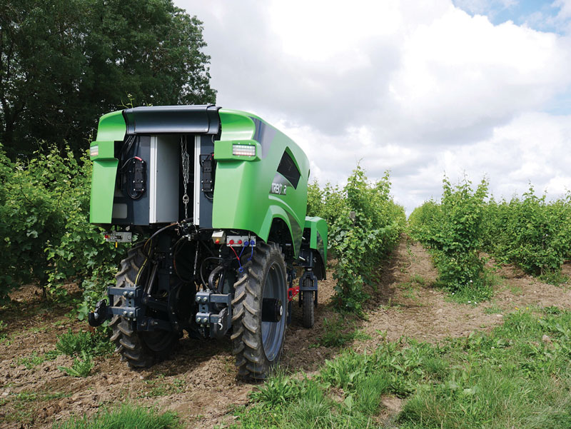
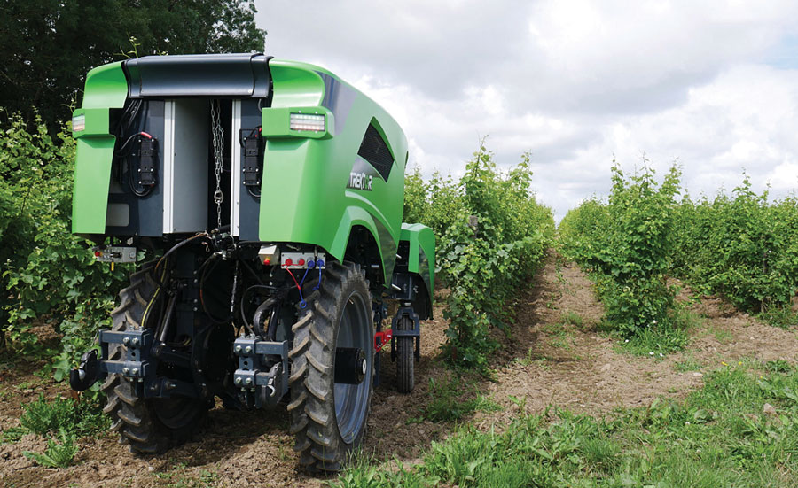
The Trektor hybrid robot for agriculture, made by the French company SITIA, can work on a variety of crops by changing the width of its wheelbase and can perform many repetitive tasks, such as spraying and hoeing. (Image: SITIA)
Precision agriculture has been around for more than 30 years and now covers the majority of U.S. farmland. It refers to the ability of farmers to observe, measure and respond precisely to the variability of soil and crop characteristics within and between fields by using maps of these characteristics and GNSS navigation. It enables them to reduce inputs of seed, water, fertilizer, pesticides and fuel while increasing outputs. It also enables them to work at night and in the fog and automate many functions at large feed lots.
For precision agriculture, GNSS integrity can mean the difference between, say, a robot protecting a vineyard by weeding and spraying pesticides or damaging it by straying onto the vines.
Autonomous Tractors, Mowers, and Feed Monitors
SITIA, a French company, has developed an autonomous tractor that is used by, among others, an organic vineyard in France’s Loire valley to tirelessly weed the narrow rows between the grape vines — compensating for the movement of young workers to cities. Thanks to the high accuracy and integrity of the Septentrio GNSS heading receiver inside, the autonomous tractor has decreased the damage to the vineyards by more than an order of magnitude compared to the traditional work done by a farmer with a manual tractor.
Renu Robotics, based in San Antonio, Texas, makes a robot for vegetation management, called Renubot. It uses machine learning, a form of artificial intelligence, to plan its route, optimize its energy consumption, perform self-diagnostics, collect environmental data and assess the topography that it traverses.
Navigation is based on a stored map of paths, a Septentrio RTK GPS receiver and sensors to avoid obstacles. A radio link enables the Renubot to communicate with a control center, for reporting and updates. When the Renubot returns to its recharge pod, it charges its lithium battery and performs updates and downloads.
Manabotix Pty. Ltd., an Australian company, has developed an automated system to monitor cattle in large feedlots, using GNSS, lidar scanning and other vision or perception technologies and artificial intelligence. This has greatly improved the accuracy and consistency of feedlot volume estimates, which for the previous 150 years had been the responsibility of a select few employees, who would visually gauge the amount of feed in concrete troughs. This visual inspection by humans was inherently imprecise, subjective, and inconsistent, often causing animals to eat too much or too little one day and get off their optimal growth curve or even become ill. Manabotix’s solution consists of a Septentrio AsteRx-U GNSS receiver and antenna, a lidar scanner, and an onboard processing platform.
Statistical Analysis
Integrity is a key aspect of all these applications. A part of delivering integrity is a statistical analysis called receiver autonomous integrity monitoring (RAIM), which was developed for such safety-critical applications as aviation or marine navigation. A refinement of RAIM, called RAIM+, takes this analysis to the next level as part of a larger positioning protection package.
For autonomous operation, it can be particularly hazardous to be overly optimistic about GNSS accuracy. This parameter is reported in the form of positioning uncertainty, which is the maximum possible error on the calculated position. It is especially necessary in challenging GNSS environments, where the receiver has a direct line of sight to only a limited number of GNSS satellites or where GNSS signals are degraded. RAIM alerts users when their receiver’s uncertainty strays beyond the limits they have chosen for their application.
Users can be deceived by a consistent position or movement — which can be consistently inaccurate. The positioning uncertainty gives them an indication of the extent to which they can rely on their receiver’s positioning accuracy at any given moment. The receiver operator can set an alarm limit, so that the receiver can flag situations when positioning uncertainty becomes too large.
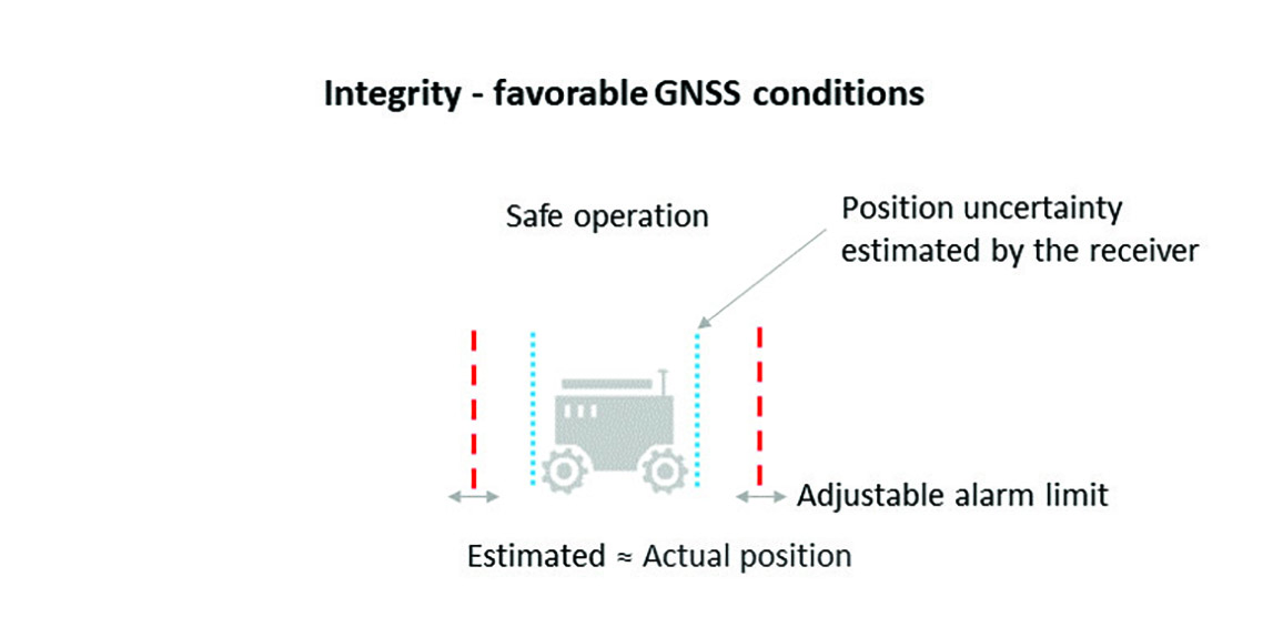
The blue line in Figure 1 shows position uncertainty estimated by a GNSS receiver under favorable conditions, when the view of the sky is unobstructed, and the receiver has a direct line-of-sight to many satellites.
Figure 1. Under good GNSS conditions, the position uncertainty shown by the blue lines is well within the alarm limits, indicating safe operation. The actual position of the receiver should always remain within the blue uncertainty boundaries. (Image: Septentrio)
During favorable conditions, the positioning uncertainty stays well below the alarm limit because the calculated position is almost the same as the robot’s actual position. However, in challenging environments, the truthfulness of positioning uncertainty becomes most critical (see Figure 2).
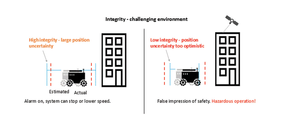
Figure 2. In challenging environments receivers with high integrity report large positioning uncertainty, flagging possible inaccuracies to the system. If the receiver is too optimistic about its accuracy, the operation becomes hazardous. (Image: Septentrio)
For instance, when the view of the sky is partially obstructed by buildings or foliage, the receiver has access to only a limited number of GNSS satellites, making it harder to calculate accurate position. In such cases the receiver must report a higher positioning uncertainty, so that the system can take adequate action such as switching to lower speeds, staying further away from predefined boundaries, or stopping.
A low integrity receiver may keep reporting an optimistic positioning uncertainty, that stays below the preset alarm limit even when the calculated position is way off from the actual position. The number may look fine, but effectively it becomes a “robot on the loose,” no longer on its planned path with a risk of damaging itself and its surroundings.
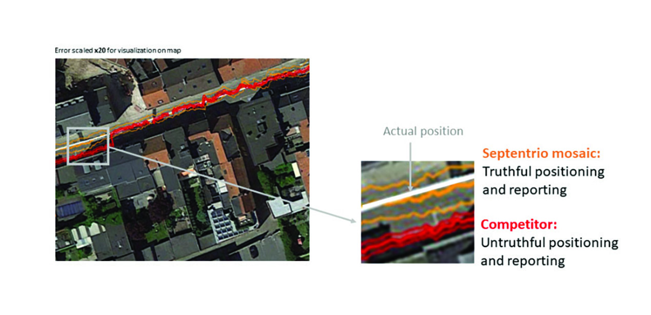
Let us look at uncertainty limits in action during a GNSS car test in an urban canyon, where the view of the sky is partially obstructed by houses (see Figure 3). The orange lines are the positioning and its uncertainty boundaries reported by a Septentrio mosaic GNSS module in the car, while the red lines are the positioning and its uncertainty boundaries reported by another popular GNSS receiver. The white line shows the actual position of the car as it drives along the road. The orange uncertainty boundaries of the mosaic receiver are truthful and somewhat wider in this challenging environment, and you can see that the actual position always remains within these boundaries. On the other hand, the red trajectory jumps off course in a certain challenging spot on the road, with the actual position no more within the uncertainty boundaries, which remain too optimistic. In this case the competitor’s receiver gives a false sense of security and the system is unaware of its hazardous operation.
Figure 3. In an urban canyon car test the Septentrio receiver reports truthful position uncertainty. A competitor receiver seems to be more accurate, while the actual position is not even within its reported uncertainty boundaries. (Image: Septentrio)
If the receiver depicted by the red line provided navigational information for an ADAS automotive system, for example, this could mislead the system into thinking that the car switched lanes. If the system then attempted to correct the trajectory by switching back to the “correct lane” this would result in taking the car off course and potentially hitting the sidewalk or even another car.
RAIM vs RAIM+
The underlying mechanism behind truthful positioning uncertainty reporting is RAIM, which ensures a truthful positioning calculation based on statistical analysis and exclusion of any outlier satellites or signals. Septentrio receivers are designed for high integrity and take RAIM to the next level with RAIM+, guaranteeing truthfulness of positioning with a high degree of confidence.
In Septentrio receivers RAIM+ is a component of a larger receiver protection suite called GNSS+ comprising positioning protection on various levels including AIM+ anti-jamming and anti-spoofing, IONO+ resilience to ionospheric scintillations, and APME+ multipath mitigation.
Septentrio has fine-tuned its RAIM+ statistical model with more than 50 terabytes of field data collected over 20 years. It removes satellites and signals which may give errors due to multipath reflection, solar ionospheric activity, jamming and spoofing, while working together with the GNSS+ components mentioned above. Because of this multi-component protection architecture, it achieves a very high level of positioning accuracy and reliability which goes well beyond the standard RAIM. The RAIM+ statistical model is adaptive, highly detailed, and complete, taking advantage of all available GNSS constellations and signals. The full RAIM+ functionality is also available in Septentrio’s GNSS/INS receiver line. User controlled parameters allow it to be tuned to specific requirements.
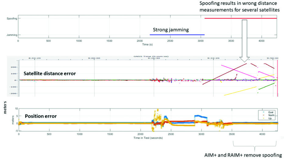
The diagram in Figure 4 shows RAIM+ in action during a jamming and spoofing attack on a Septentrio GNSS receiver. While AIM+ removes the effects of GNSS jamming, both AIM+ and RAIM+ work together to block the spoofing attack. Satellites with high distance errors, shown on the middle graph, are removed by RAIM+ since they do not conform to the expected satellite distance.
Figure 4. In this scenario jamming gives satellite distance errors but is countered by AIM+ technology. During spoofing AIM+ eliminates some of the spoofed satellites, while other satellites that have wrong distances are dismissed by RAIM+ algorithms. (Image: Septentrio)
This example shows that even in the case of jamming and spoofing, Septentrio’s high integrity receiver technology delivers truthful and reliable positioning on which any autonomous system can count.
GNSS Design Around Reliability
GNSS receivers designed to be reliable strive for high integrity in both reporting of the positioning uncertainty as well as in RAIM+ advanced statistical modelling. This ensures that these receivers provide truthful and timely warning messages and are resilient in various challenging environments. Other technologies such as inertial navigation system (INS) can also be coupled to the GNSS receiver to extend positioning availability even during short GNSS outages. Quality indicators for satellite signals, CPU status, base-station quality and overall quality allow monitoring of positioning reliability at any given time. High-integrity GNSS receivers provide truthful positioning in autonomous machines such as the SITIA weeding tractor. They are also crucial components in safety-critical applications, assured PNT and any other application where accuracy and reliability matters.
L’avion jaune, a French UAV and aerial photogrammetry company, uses the Trimble Applanix APX-20 UAV GNSS-inertial OEM solution and a YellowScan VX-20 lidar on its M600 multirotor UAV. (Image: L’Avion Jaune)
The breakdown of limestone cliffs generates landslides and loose debris that threatens the environment, people and wildlife below. These conditions make it impossible to safely operate traditional survey equipment from the ground for landslide detection. Using UAVs for direct georeferencing is an efficient way to take traditional survey efforts to the sky and enables users to accurately assess land formations while mitigating risk.
One way to implement direct georeferencing on UAV platforms is with the Trimble APX-20 UAV, which is a GNSS-inertial OEM solution that increases the mapping efficiency of small UAVs. It consists of small, low power, precision GNSS and inertial hardware components and POSPac UAV post-mission differential GNSS-inertial office software. The APX-20 UAV eliminates the need for ground control points and reduces the sidelap required to be flown per flight.
The APX-20 UAV contains a precision, survey-grade GNSS receiver and dual inertial measurement units (IMU), so it automatically supports integration on gimballed platforms without requiring an external interface to an autopilot or on a mount. It computes at 100 hz using the embedded IMU while simultaneously logging the raw IMU data from both the internal and external IMU at 200 hz for post-processing in POSPac UAV. The postprocessed position and orientation solutions are suitable for direct georeferencing of cameras, lidars and other sensors.
Trimble Applanix UAV Put to the Test
For fast and safe landslide detection, the Trimble Applanix APX-20 UAV for direct georeferencing was put to the test using a Multirotor M600 manufactured by French company L’Avion Jaune equipped with a VX-20 lidar sensor made by YellowScan, also a French company. This combination produces cost-effective and reliable high-resolution UAV lidar-derived DTMs and 3D models for hazard mitigation and planning.
L’Avion Jaune has performed more than 600 successful mapping missions globally. After pursuing mapping activities with mainly crewed aircraft, it began developing UAVs for long-distance applications for marine, tropical forest and polar regions such as the Multirotor M600/YellowScan VX-20, which offers high-precision, cost-effective and efficient aerial mapping.
The APX-20 UAV and the M600/YellowScan VX-20 were combined and deployed to evaluate landslide activities in France. The mission parameters for this configuration included: high point density; x, y, z precision of 5 cm; access to dangerous zones; map generation under dense vegetation area, and fast deployment. The goal of this project was to enable the implementation of safety and prevention plans for the protection of pedestrians, infrastructure, wildlife and more.
During the six-hour duration of the project, the APX-20 UAV and M600/YellowScan VX-20 configuration was flown four times for 15 minutes each during sunrise. It flew more than 75 ha in surface area with a flight speed of 5 m/s at 60 m in the air, following the topography. Checkpoints were surveyed with differential GPS following the conclusion of the flights. Data processing included computation of the georeferenced trajectory, matching flight lines and point cloud classification, which took two days.
The Results
The flexible UAV deployment of resources enabled the acquisition of dense point clouds and the generation of DTM in less than three days. During this project L’Avion Jaune was able to optimize the choice of material and discover the best practices to collect and process lidar data for mapping in dense vegetation.
Thales Alenia Space, along with Viettel and MKE, have been selected by Vinamarine to provide Vietnam with a MEOLUT Next ground station. MEOLUT Next will operate as a part of the COSPAS-SARSAT global medium orbit search-and-rescue (SAR) network.
The SAR solution will enable the detection and location of distress signals from COSPAS-SARSAT beacons on land, in the air, and at sea over a radius of 2,500 km around Haiphong, Vietnam, mainly using signals from Galileo.
Thales Alenia Space’s MEOLUT Next solution employs a phased array antenna and can track more than 30 satellites, which enhances distress beacon detection and expands coverage. The solution can detect and locate distress signals from more than 5,000 km away.
MEOLUT Next is used by other COSPAS-SARSAT users including Canada, the United States, France, the European Union, Togo and Thailand.
NAVKITE on board a vessel. (Image: Safran Electronics and Defense)
Safran Electronics and Defense and Fuscolab, the innovation lab for the French Marine Corps, released a resilient position, navigation, and timing (PNT) system, NAVKITE. It provides navigation integrity and performance over long periods of time and under demanding circumstances on land and at sea.
NAVKITE meets operational requirements for the French Navy Commandos and will be integrated in Embarcation Commando a Usage Multiple Embarquable (ECUME) — a transportable, multirole, semi-rigid boat purpose-designed for commandos and other special forces.
NAVKITE’s capabilities depend on the coupling of Safran’s Geonyx M inertial navigation system with the VersaSync time/frequency server. Together, they handle the transmission of PNT data to ensure mission continuity.
The first sea trials of the system, conducted by Fuscolab and the Ponchardier commando unit, demonstrated NAVKITE’s performance under operational conditions. It was then successfully deployed in February in the joint services exercise Hemex, during phase two of Orion, a large-scale operation for resilient, innovative and interoperable armed forces focused on high-intensity conflicts.
Thales Alenia Space has signed a €43 million contract for the Euro High-Altitude Platform Systems (HAPS) demonstration project. EuroHAPS was selected by the European Commission on July 20, 2022, for collaborative defense research and development projects from the European Defense Fund.
EuroHAPS aims to develop several stratospheric demonstrators for missions designed to improve intelligence, surveillance and reconnaissance and communications capabilities. Project partners include companies from Italy, Spain, Germany and France.
The project will conduct flight demonstrations for three types of complementary stratospheric platforms: A reduced-scale Stratobus from Thales Alenia Space, a solar-powered airship designed for long-endurance missions and offering large payload capacity, Hybrid High Altitude Airship from the Italian Aerospace Research Centre capable of generating extra lift with a wing airfoil, and autonomous stratospheric balloon system from ESG and TAO consisting of a series of three altitude-controllable balloons.
These three types of platforms are complementary and feature different operating times, capacity and operational restrictions. They will give Europe a broad spectrum of solutions to meet a variety of different requirements.
The platforms will test a range of missions, including lidar observation to detect and classify targets at sea or on land and the ability to detect them in environments with vegetation cover. Communications intelligence and electronic intelligence missions will also be tested, as well as a meshed broadband communications network for air and land players.
HAPS offer a new opportunity to complement ground-based, satellite-based or airborne assets with unique capabilities tailored to operational requirements. These flight demonstrations of HAPS will enable demonstrations of different platforms and address the main technical risks associated with these new technologies while refining operational requirements to ultimately enable development of future HAPS systems.
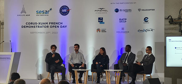
The flight test is the third of several to simulate a variety of real-world scenarios that demonstrate how UTM and ATM intersect with multiple aircraft types.
M3 Systems, Pipistrel and Volocopter have completed their first joint flight test campaign in France at Pontoise airfield.
The week-long flight tests simulated three different avoidance maneuvers in real-world situations where unforeseen circumstances occur, such as a complete airport or vertiport closure, an unavailable final approach and takeoff area, and traffic deconfliction.
M3 Systems was created from engineering activities in GNSS and consulting activities in air traffic management (ATM), including for uncrewed aircraft. M3 played a role in Galileo signal definition, among other projects for Europe’s various space agencies. Pipstrel is a light aircraft manufacturer specializing in electric propulsion, and Volocopter specializes in urban air mobility (UAM) systems.
The joint campaign among the three companies — with French partners Groupe ADP and its subsidiary Hologarde — aimed to achieve smooth interaction within and between the new lower airspace’s unmanned traffic management (UTM) and standard civil aviation ATM systems.
The Boreal system is a fixed-wing UAV with high-endurance and heavy payload capacity. (Photo: M3 Systems)
The aviation industry is experiencing an innovation upsurge driven by technology and societal pressure for new forms of aviation focused on sustainable, digital and autonomous air mobility. The resulting solutions will generate a significant increase in traffic density in the lower airspace.
Because existing ATM systems are not designed to handle such volumes or digitalization, coordinating existing and new traffic management systems for brand-new aircraft integration will ensure efficient large-scale operations. This includes commercial, general and drone aircraft for cargo and passenger flights, both crewed and uncrewed.
The CORUS-XUAM project, funded by the European Union’s initiative Single European Sky ATM Research (SESAR) Joint Undertaking, focuses on solving the challenge of conventional and new traffic management system integration and consists of 19 partners and 11 third parties. M3 Systems, Pipistrel and Volocopter all completed individual flight-test campaigns before this event to bring their aircraft in line with the U-space services.
A week of flight tests ended with an Open Day air show and presentations. (Photo: M3 Mobility)
The CORUS-XUAM flight test conducted at Pontoise airfield near Paris is the third of several flight tests to simulate a variety of real-world scenarios that demonstrate how UTM and ATM intersect with multiple aircraft types.
Moreover, the CORUS-XUAM project will continue to proactively test and create a safe and controlled lower airspace under the European Union’s ambitious Single European Sky (SES) initiative throughout 2022.
The successful flight tests at Pontoise airfield were conducted with M3 System’s Boreal remotely piloted aircraft system, Pipistrel’s crewed Velis Electro, the only type-certified electric aircraft in commercial service in the world, and Volocopter’s fullscale, remotely piloted 2X prototype. Pipistrel uses the conventional ATM tower and system while Volocopter and M3 Systems use the UTM system. The following three flight scenarios were tested:
The unexpected occupancy of a final-approach-and-takeoff plan and aircraft diversion because of priority landing of another aircraft (Pipistrel and Volocopter aircraft).
The diversion of a flight path because of the closure of an airport or vertiport (M3 Systems).
The diversion of a flight path with two aircraft flying the same path (M3 Systems and Volocopter aircraft).
“These successful tests confirm that our Boreal UAS will be an enabler for future XUAM operations in situations where aircraft need to safely divert paths to another vertiport due to an unforeseen closure or another aircraft in the air,” explained Marc Pollina, M3 Systems CEO. “By providing rerouting demonstrations and tactical communications with U-Space service providers, M3 Systems can support future coordination between AAM and airport operators.”
Pipistrel is “As the manufacturer of the only type-certified electric aircraft in commercial service in the world, proud to take part in technical projects that shape the vision of air mobility and make progress in a meaningful way,” said Gabriel Massey, Pipistrel president. “The CORUS project and Paris demonstrations clearly show how UAM vehicles will be able to fly safely in regular airspace post-2030 and will help to unlock new lower-noise and lower-emission air passenger and air cargo services.”
In 2019, Volocopter tested its 2X ATM integration at Helsinki airport and was actively involved in the development of the European U-Space Concept of Operations, according to Oliver Reinhardt, Volocopter’s chief risk and certification officer. “Building an efficient ecosystem around UAM is Volocopter’s mission, and connecting ATM/UTM integration with our digital platform, VoloIQ, is poised to be an integral part of bringing UAM to megacities worldwide,” Reinhardt said. “I am looking forward to the next CORUS-XUAM test flights later this year in Germany and what we can achieve there.”
The project has received funding from the SESAR Joint Undertaking under the European Union’s Horizon 2020 research and innovation program under grant agreement No. 101017682.
YellowScan will host its fourth conference for drone users June 13-14, 2022, at Domaine de Verchant, Montpellier, in the south of France. Attendees at Lidar for Drone 2022 will be able to meet and link up with YellowScan customers, partners and distributors.
Attendees will gain insight into the lidar industry and hear from interesting and innovative lidar users, thanks to an extensive program of technical sessions, workshops, live demonstrations and training.
There will also be networking opportunities — the user conference is a great chance for attendees to showcase their involvement in the lidar market.
This year’s conference will include a celebration of YellowScan’s 10th anniversary.