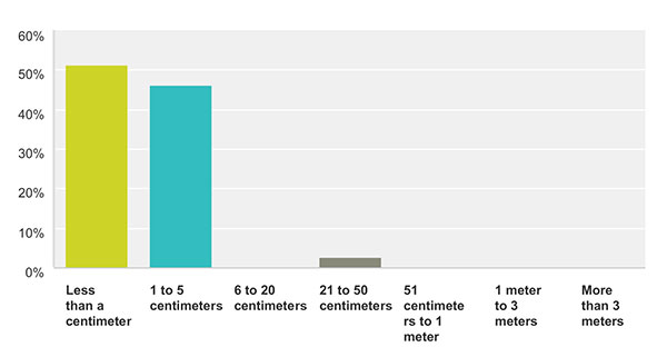
How accurate is good enough for the majority of your market sector? This chart show the answers from those who identified themselves as members of the survey and high-precision community. For more results from this and other sectors, see the 2015 State of the GNSS Industry Report.
Memory fails as to who first said “Accuracy is addictive.” Or perhaps it’s my knowledge base that is deficient. At any rate, I’ll gladly publish documented evidence from anyone who can show the earliest — print or audio — expression of that dictum. It continues to hold as true for this industry as Moore’s Law does for computer technology as a whole.
We have seen the gradual tightening of accuracy requirements across all sectors of the positioning, navigation and timing (PNT) community with each successive iteration of our State of the GNSS Industry Survey, now in its fourth year. This is the first time we have seen it cross the 1-centimeter line. Not in capability; sub-centimeter capability has been available for some time. But now that level of performance is the minimum acceptable “good enough” for more respondents in the survey and high-precision sector than any lesser degree of accuracy; in fact, greater than all other ranges combined. These addicts form the new majority. Their preferences and their behaviors will rule our world.
Other sectors will presumably answer likewise in coming years, following the trail blazed by the high-precision pioneers.
We have crossed the Rubicon. Unlike other obsessive behaviors, there is no going back in our case. This path is a one-way road to — well, not to the various hells entailed by other addictions — but to the promised land of always-on, always-true, near-perfect provision of positioning.
Let’s not kid ourselves, however. The perfect world does not exist. The closer we get to millimetric accuracy, the more obstacles we find in our way. Indoor continuity aka ubiquity, jamming, spoofing, hacking, budget cutbacks, slides to the right — this list will surely grow.
The more acute our addiction, the lower our tolerance for less-than-total fulfillment.
Of it all. Of the broad expanse of the world and all its inhabitants, its layers, its depths and heights, the atmospheric mantle in which it wraps itself, its floating mountains of ice and its solid soaring peaks of rock and snow, its savage predators, and all its shades of human endeavor.
Every August we marvel at the many applications of global positioning science, at real-world instances of hardware and software in the service of humankind and of Gaia itself.
Eleven months out of the year we chronicle the business and technology of GNSS, as it says on the cover. Eleven months we busy ourselves with explorations of R&D, of novel concepts and experimental tests, of integration and augmentation and propagation and limitation and innovation; of algorithms and systems, theorems and OEMs, robotics and aeronautics, UAVs and degrees, integrity and capability and availability and mobility and connectivity and security, functionality and ambiguity and compatibility and velocity and linearity.
Every once in a while we have to stop amid all this admittedly somewhat abstruse science and ask ourselves: “GNSS — what is it good for?”
Answers are never lacking. Since Ivan Getting originated the idea of lighthouses in the sky for humanity in the 1960s, inventors have put forward new solutions for vexing problems — sometimes solutions for what we didn’t know was a problem, but upon investigation turns out to have a profitable resolution. Witness the stories in this issue, from sharks to space, from mountaintops to multi-sensor navigation under interference or heavy canopy.
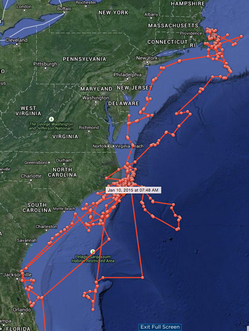
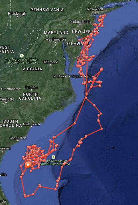
Now about those sharks. In case you were wondering whether Katharine or Mary Lee might have been culpable in the seven shark bitings off North Carolina during May and June — they were not. The maps here and their GPS timelogs give both solid alibis for all the attacks in question.
Katharine’s cruising over the past year.Mary Lee’s meandering over same time.
Sometimes you have to stop and, yes, smell the roses, but also survey just how far you’ve come, where you stand at this actual moment, and what directions hold the most promise for the future. When you’re moving as fast as the GNSS and PNT industries do, a periodic pause to assess becomes even more vital.
That’s why we conduct the annual State of the Industry Survey, which generates the State of the Industry Report.
Your part in this, the Survey, starts July 15, when the online survey will be posted at env-gpsworld-integration.kinsta.cloud/State15, and remain at that link until August 10.
Our part, the Report of your filings, will appear in the September issue.
Past State of the Industry Reports have borne such insights as these.
September 2012. “Careful optimism appears to be the watchword for the GNSS industry as we head into the next year, tempered with the reality that a full economic recovery has not yet arrived; 65 percent of respondents described the market for GNSS products and services as enjoying either moderate growth or strong growth. ‘With the economy in the state it is in, competition is very tight. That is all right, it keeps our pencils sharp,’ wrote one industry veteran.”
September 2013. After the passage of one year, 69 percent described the market for products and services in their sector as either relatively healthy or very healthy. That’s what’s known in economic circles as “a modest increase.”
Dominating executives’ and managers’ awareness as a key issue shaping the future that year were three candidates, according to John Pottle of Spirent Communications. “Vulnerability of GNSS signals, the flurry of activity following the release of the BeiDou system ICD, and the continuing indoor navigation challenge. Whatever your viewpoint, one thing is clear: there remain plenty of challenges for us all, as indusry insiders, to solve over the coming years.”
October 2014. With another 13 months under our collective belt, we had not fully mastered any of those top three challenges — but we had logged significant progress. Jamming, both intentional and unintentional, along with spoofing led all concerns for 28 percent of survey respondents, and if “constellation health” were added to those worries, fully half of our experts — meaning you — deemed this the industry “issue of the year.” Meanwhile, the percentage of those finding moderate to strong growth in their sector had risen to 74.
Michael Ritter of NovAtel spoke for many when he wrote, “Ultimately, GNSS itself will no longer be enough. Ubiquitous positioining requires multi-sensor fusion that can exponentially increase availability.” And he revealed that NovAtel spends 30 percent of its annual revenue on research and development.
The Future Begins Now. Only you, in your collective wisdom, can tell us where we stand and where we’re headed. I encourage you to help us compile the State of the Industry by filling out a relatively quick online questionnaire. Look for it to be posted on July 15.
It is heartening to see a burgeoning constellation and its operators move on from doubt to certainty, as Galileo prepares for fuller operational capability and the expectations that scope elicits.
To pick up the thread from last month’s column covering keynote speeches at the European Navigation Conference: plenaries subsequent to the opening session focused respectively on “GNSS for Aeronautical Applications: from GPS to Multi-Constellation with Galileo,” and “GNSS Resilience for Terrestrial & Naval Applications.”
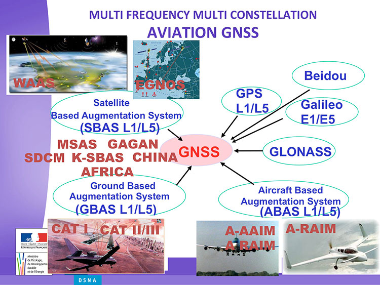
Avionics. Benoit Roturier, GNSS and Performance-Based Navigation program head for the French air traffic control agency, Direction des Services de la Navigation Aérienne (DSNA), reviewed the rather complex assembly of air navigation systems gradually coming together. Not quite — or not nearly — a system of systems, as I understand it, more a conglomeration of systems.
Slide from Benoit Roturier’s presentation on behalf of the French air traffic control agency. (Courtesy of Benoit Roturier)
Multi-constellation GNSS combos, with added context from satellite-based augmentation systems (SBAS), target provision of performance-based navigation (PBN) in all phases of flight, with increased robustness and availability, as well as escalating categories of precision approach and landing. Roturier presaged the SBAS message agreement that also took place in April with his observation that “[The] most benefits are achieved with two constellations — but which ones?” As four constellations and two frequencies deliver “many, many potential navigation modes,” how can air traffic controllers limit complexity while achieving maximum benefits? At the very least, there is a need to agree on main mode and reversion modes.
He gave an overview of upgrades planned, in progress, and completed at airports around France. 141 runways are as of January 2015 equipped with PBN, with GNSS and often EGNOS approaches, compared with 260 still relying on older systems. He concluded with a summary of DSNA views, including “SBAS/EGNOS is seen as a free of charge, performing, mature and here to stay technology, supporting navigation and surveillance (ADS-B) performance requirements.”
By the way, June’s EAGER enewsletter column will cover a recent EGNOS demonstration flight and the current state of runway approaches in Europe. Subscribe here for free.
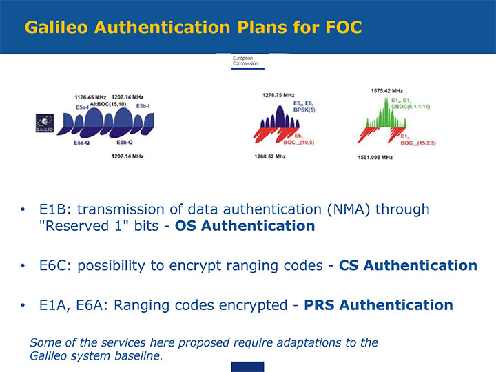
GNSS Resilience. The second plenary, on resilience, brought forth some of the most pointed commentary of the conference. Ignacio Fernández Hernández of the European Commission spoke on Galileo differentiators for resilience: its authentication plans for the Open Service, Commercial Service, and Public Regulated Service, respectively. “The proposed GNSS authentication services are 100 percent backward compatible and interoperable with other receiver-based technologies.”
Slide from presentation by Ignacio Fernández Hernández of the European Commission on Galileo differentiators for resilience. (Courtesy of the EC)
Hernandez proferred the caveat that “some of the required changes to deliver these services (particularly OS authentication) are pending on an impact analysis by industry/ESA and are not yet in the baseline. We hope however to have them in the baseline soon and we’re working hard for it.”
Matteo Paonni of the EC’s Joint Research Centre addressed spectrum management and regulatory issues, specifically the hot-button topic pseudolites. The EC is working closely with the United States and others to limit potential in-band interference risks. Outdoors, pseudolites are clearly undesirable; indoors, they offer some potential, but must be controlled.
Paonni stressed that there is a clear need to protect GNSS spectrum, and that the EC and its member states are doing their utmost to install such protections, and are also promoting GNSS radio-frequency interference detection and mitigation initiatives. Galileo’s PRS is more robust and resilient, but it is not invulnerable. GNSS vulnerabilities should be appreciated and backups put in place for critical systems; backups such as eLORAN, mini atomic clocks, GSM network, and so on.
Michel Monnerat of Thales Alenia Space focused on resilience in the road and LBS sectors. With a wide range of environments, devices and applications coming into play, “we need standardization” to specify levels of integrity and levels of performance for each different set of parameters. Thales Alenia is developing just such a set of performance requirements and references, with a first version set for release and discussion soon.
Slide presented by Michel Monnerat of Thales Alenia Space, which is working on a standardization protocol proposal, to be released soon. (Courtesy of Thales Alenia Space)
We appear incompletely before you this month. A funny thing happened on the way to the presses: we discovered that we had more content than pages in which to squeeze it. “All the news that fits to print,” the motto of the New York Times, can in this instance not be ours. All the news just won’t fit!
First to feel the axe, lamentably, was Innovation, an article on the Python receiver; you will see it in February. Also pushed to the near future is reporting on the recent Stanford PNT Symposium; it appears in the December GNSS Design & Test e-newsletter, see the website if you don’t yet subscribe. Herewith, an ultra-brief account of a presentation by Greg Turetzky, Intel. The reporters identified this paper and one on BeiDou as “harbingers of change in the industry.”
The Turetzky paper, “Ubiquitous Location: Challenges and Opportunities ofEnabling All-day, Everywhere Location for All Mobile Platforms,” laid out the phenomenal growth of location-based services and the implications for design requirements in GNSS-wireless at the user device and silicon levels. The compound annual growth rate of GNSS devices will continue, from its current 22 percent level to a robust 9 percent for the years 2016–2022, and heading for seven billion installed units by 2022.
From Greg Turetzky’s Ubiquitous Location paper, presented at Stanford PNT Symposium.
Cutting to the chase, the design challenges for GNSS are to:
Take advantage of smaller geometries to achieve higher clock speeds, more memory, lower active power and smaller size, while reducing standby power from leakage;
Incorporate new methodologies in chip and system design; integrate multiple radios on a single die to reduce cost and size;
Integrate multiple radio sources into a single location solution;
Bring together a disparate value chain.
The technology roadmaps embrace most modalities of positioning: GNSS, Bluetooth, Wi-Fi, cellular, and SBAS, and cross most platforms, including wearables. “We think that another, unemphasized challenge,” reporters Litton and Langenstein note, “is in the increasing density of these units with the current specifications on out-of-band emissions and the spectrum sharing and spectrum management factors in the ubiquity of the devices.”
Tune in to our free webinar Receiver Design for the Future,with Greg Turetzky of Stanford speaking on Ubiquitous Location, scheduled for Jan. 15 (1 p.m. EST/ 10 a.m. PST/ 6 p.m. GMT). Register today!
The next time I see Paris, I will be swinging down the boulevard in a brand new set of threads. An elegant, location-enabled set of threads that will take me by the sleeve and lead me through the City of Light.
This wearable experiment goes by the name — of course it does — Navigate, a new line of city-specific, location-enhanced apparel. Either plug or Bluetooth the jacket (the press materials are not clear on this point) into your smartphone, download the appropriate city guide with walking tour, and start your adventure. Stash the phone in the pocket of the houndstooth jacket with red felt collar flips, no further need to look at it. Vibrations along left or right arm tell you when to turn; their frequency, intensity, and placement vary to indicate soft turn, merge, or hard turn.
Oh, I love the colorful clothes she wears, and the way the sunlight plays upon her hair . . . I’m pickin’ up good vibrations, oom bop bop, she’s giving me excitations, oom bop bop.
Good, good, good, good vibrations.
“How we can ease the stress of navigating an unfamiliar path without interfering with the experience of discovering a new place?” asks Billie Whitehouse, design director of Wearable Experiments. “No longer do you need to hunch over a map or smartphone. Now you can experience fill-the-blank-here as a traveler rather than a tourist.”
Not interfering with the experience of discovering a new place: that caught my attention. In my misspent youth, I traversed the upper Amazon, the Andean highlands, and the Galapagos Islands unencumbered by a camera. To my lasting regret. I thought the device lifted to my eyes would interfere with my discovery and experience. Now I see my error. Instead of subtracting a layer of technology from my travel trunk, I should have added one. That GPS did not exist at that time, except as a gleam in young Col. Parkinson’s eye, perhaps absolves the fault in this case.
“The skin is a vastly underutilized form of communication,” says Wear:Ex technical director Ben Moir. “Haptic vibrations are built into a full physical language, allowing the technology to communicate critical information. Technology doesn’t need to be invasive or obtrusive. It should be designed with the human at the center.”
From signals in space to the surface of my skin. It doesn’t get much more human-centric than that.
My colleague Janice Partyka wrote a provocative blog in the Wireless/LBS Insider on discovery of the brain’s inner GPS, which won three scientists a Nobel Prize for medicine. The piece struck me so forcefully in the hippocampus, locus of my location sensibility, that I was tempted to place it here verbatim. That would not justify me, however, in drawing my pay, so I add my two cents worth. Literally. Two cents worth.
Partyka’s theme: “How does our brain understand where our body is in space, and navigate us from home to work?” She wrote that one scientist found “a type of nerve cell in the brain’s hippocampus, our short-term memory storage bin, was always activated when a rat was at a certain place in a room. As a rat ran through a maze, a particular sequence of individual neurons fired. Other nerve cells were activated when the rat was positioned elsewhere. O’Keefe concluded that these ‘place cells’ formed a map of the room.
“When the rats slept, the same sequences of place cells that were fired earlier in the day fired again. Researchers think that this replay helps to transfer the rat’s memory of the maze from the hippocampus into long-term storage. Place cells also attach to memories of a particular location. When sitting at a table, a person or maybe even a rat might remember a pizza that was eaten at that spot.
“Many decades later, the Mosers discovered another component of the brain’s positioning system. They identified ‘grid cells,’ which are thought to act like a dead-reckoning system and generate a coordinate system to allow for precise positioning and pathfinding. The grid cells create a location to put place cells and organize position locations. Rats running around an open floor (hopefully not mine), will fire neurons that map out a grid of equilateral triangles that serve as a spatial map. Grid cells can function in complete darkness, without visual cues. Together, place and grid cells make it possible to determine position and to navigate.
“While place and grid cells were first discovered in rats, studies using brain imaging indicate that they also occur in humans.”
As I sit here in mid-October listening to the World Series (for some deeply buried irrationality, sleeping in the Americana of my mind, I believe that baseball is better on radio than on TV), I visualize the athletes lunging and spearing and leaping about the field of play, barely having to look because they know the cells and grids of it so well. They just react to the ball and — smack! — it arrives in the first baseman’s glove. And what of the pitcher, who knows the strike zone so totally, so certainly, so inwardly, at 60 feet’s distance from his outstretched arm, that he can navigate a small spheroid precisely, on a curved path no less, to its lower left corner?
Technology enhances our sense of location, as we in particular know so well. But technology can be fooled, perhaps more easily than the brain. Could the brain be convinced that its body was speeding towards Libya when in reality it placidly cruised northward in mid-Adriatic? Imagine how your brain would fare against the spoofer in this issue’s cover story.
As in, “It’s not like you’re curing cancer,” a refrain I hear sometimes when I get a bit over-inflated on GPS/GNSS and the wonders they can do in many fields of human endeavor. The intent of that remark is to remind me that on the one hand, there is technology. On the other hand, there is life, and there is death. Despite the leaps and bounds and the many alterations to life and its circumstances that technological advances have created, life — and death — still have the upper hand. And they will for the forseeable future. What’s that bumper-sticker saying? “Nature bats last.”
At the crux of the mystery of life and its endings is the nature of cancer, one of the leading causes of the end of life. Cancer is so deadly because cancer cells are immortal. They multiply endlessly, unlike normal cells that have a limit of about 30 times multiplying-and-dividing. Cancer cells take over the host body until they have crowded out enough normal cells to kill it. The cause of death in this case is . . . immortal life.
Some believe that the key to immortality, if not to perpetual youth, lies hidden inside the coding of cancer cells, and that in unlocking one mystery, we may succeed in unlocking two. But I’m treading on thin metaphysical ice here, so I’ll withdraw to the solid shore of what we do know, of what we know we know.
The first successful forays have come in the field of geographic information systems (GIS); as yet, the insights furnished by GIS are not down to the level of accuracy furnished by GPS/GNSS, but they will surely get there. And GPS itself has been employed to study the recovery rates and health issues of cancer patients, indicating further usefulness.
It’s all part of the fabric. The solutions lie at the heart of the mystery.
When I was a young man, the moment seemed like all there was, all there needed to be. Why plan? Why reflect? The days were just packed.
Once I turned 25 — or somewhere around there — intimations dawning of my own mortality, I began to look both forward and back. It seemed like a good idea, perhaps even an important one, to draw from my own history, good and bad, and use that perspective to start building a more informed, more mapped-out future.
That’s what the Special Section accompanying this issue is all about. So much goes on at all times — the days are just packed — and we are so busy formulating solutions to the challenge of the moment, whether that be spoofing or indoor positioning or adjacent-band use, that we have little opportunity to reflect on how far we have come. To take the long view on just where we want to go in the next 25 years.
In that vein, we are proud to present Brad Parkinson’s vision of the future. He brought you GPS in the past. He has his sights firmly fixed on “PTA” for the future: Protect, Toughen, and Augment GNSS to assure continuous delivery of solutions.
Brad is uniquely qualified to lay out these prescriptions for our collective future. Having been deep in the political and technical trenches, fighting to build a revolutionary new system decades ago, and in continuous engagement ever since, he knows both the vulnerabilities and the possibilities.
No mention of the 25-year history of this magazine would be complete, or even remotely accurate, without giving prominence to two individuals who shaped it from the beginning. Glen Gibbons was the founding editor and held down this chair for 16 years. He literally invented GNSS journalism. His confrère from those early days is still with us: Richard Langley logged his 200th Innovation column a couple of years ago, and it remains a cornerstone of every issue. Except August and December, when he helps us compile the GNSS Constellation Almanac.
So, back to the young man, 25 years of age, who had a head full of impressions but not much, perhaps, in the way of concrete ideas. He has turned twice that number since then, and I hesitate to state how many more. The impressions, of course, have only continued to accumulate. The ideas have started to come. Plans have formed, been left by the wayside, new plans derived, and some of them even followed. Life, it has been said, is what happens while you are busy making plans.
Take some time to wander through the back pages of GNSS industry history in the Special Section volume that accompanies this one. Read what the GPS Directorate is doing now to make things even better. Absorb the necessary strength and vision — Dr. Parkinson’s PTA prescription — we’ll need for the future.
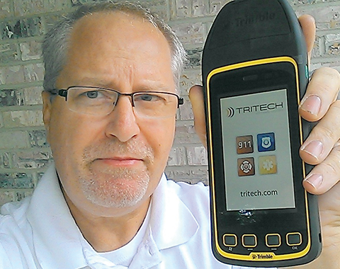
JEFF FEHLBERG, winner of the drawing for a Trimble Juno T41, grand prize in the 2013 State of the Industry Survey. You, too, can be this lucky!
Like Olympic athletes, doctors without borders, and magicians, members of the GNSS community constitute an informal international group that gathers periodically, in different centers around the world, to share knowledge and advance their craft. It is due and fitting, perhaps even necessary, that we also try to summarize or collect our views about ourselves, our field, and our future. The State of the Industry Survey is an effort to do just that.
Last year’s Survey drew 893 responses from I lost count of how many countries; the results were published in the September issue. The questions for the 2014 Survey appear on the pages immediately following, and the online interactive Surveyis now live, through the end of August. You can win cool stuff simply by answering 20 questions.
Displayed here are last year’s top prize winners. Jeff Fehlberg, a mobile business analyst from Tritech Software Systems in Little Rock, Arkansas, garnered the rugged handheld Trimble.
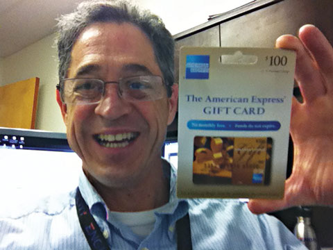
John Zittere of Engility Corporation in Hollywood, Maryland, sent along a selfie with giftie, and a few comments: “I really do enjoy reading GPS World and I also suggest it to our new-hire engineers. Here are a few pics from our Automated Aerial Refueling tests in Niagara, New York (see below).”
JOHN ZITTERE with his dinner ticket, the second raffle prize from the 2013 survey.
Also receiving gift cards for completing the 2013 Survey: Jinghui Wu of Kensington, New South Wales, Australia; Dr. S.M.A. Rizvi from Aligarh, Uttar Pradesh, India; and Rui Barradas Pereira of GMV in Lisbon, Portugal.
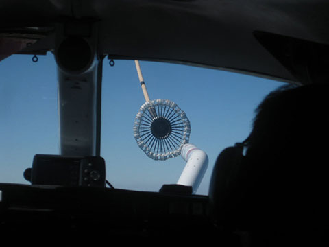
CALSPAN Lear Jet with the probe (non-functional but flight ready).AAR016, view of the tanker drogue from the Lear Jet.
Sometimes the patient has to get sick in order to get better. The eruption of a malady leads to identification of an underlying condition; appropriate treatment can then be devised to cure the body of its ills. Sound like House, M.D.?
As a variant on this plot line, the patient can know full well what is wrong deep down inside, but refuses to acknowledge or deal with it. As in, “I’ll stop smoking when I start coughing,” or “My drinking hasn’t gotten to the problem stage . . . yet.”
Let us examine the patient GNSS. The April signal outage, system-wide on the GLONASS constellation, lasted less than 12 hours. That was long enough to cause consternation for end users around the world, and for several voices to renew their calls for multi-constellation GNSS and alternative PNT. The interruption was also short enough that it has now vanished from most rear-view mirrors. Everything is back to normal and everyone can go about their business.
But the patient is still unhealthy, and vulnerable.
It is easy enough to fault the system operators, who after all are only human, and to say, “That can’t happen here. We have enough safeguards in place. And our guys and gals are just that good.” In other words, we take enough antibiotics and are generally, you know, well, healthy. As healthy as anyone else.
We have yet to see a full-scale jamming or spoofing attack on the order of cyber-security breaches in other targeted areas that have made off with millions or billions of dollars.
We have yet to experience a truly major-league Sun event, when global circumstances would be in dire need of PNT help just when GNSS was least helpful.
We have yet to encounter some other unknown, unexpected event or environment that will reveal in painful detail the vulnerabilities of GNSS.
Which are well known to us at this writing.
This month’s cover story on a new enhanced differential Loran technique represents one arm of geospatial-medical research. Notably, it evinces little concern for GLONASS, the area where the latest malady erupted. No, the Dutch harbor pilots are concerned about over-reliance on GPS, the Gold Standard. The Gold Standard! What could possibly be wrong with the Gold Standard? After all, it’s golden.
GPS III Misses Delivery Date. The U.S. Air Force is shopping for alternative companies to make future GPS III satellites after the first eight birds come through. Current contractor Lockheed Martin Space Systems missed a 2014 delivery date because, although it has three satellites in the production barn and a satellite test-bed vehicle that has successfully passed system tests, it has received no payload from subcontractor Exelis to put aboard same.
Delivery of the first GPS III satellite is now expected to slip from fiscal 2014 as far as fiscal 2016. Then there’s launch to consider, which brings to mind the launch budget and schedule, annually trimmed back by Congress. Then there’s OCX, needed to operate GPS III, also struggling to stand up.
Even once established, GPS III will share the same vulnerabilities of current GNSS.
For some years now, we have been talking about GNSS interoperability. The concept has received so much careful attention at conferences, in R&D laboratories, in international working group forums, and behind closed high-level government and military doors, that one might understandably conclude that we have talked interoperability into existence.
Not quite. Not nearly. Not by the farthest, if measuring into the next decade constitutes far, reach of our actual, real-world grasp.
“If you can imagine it, you can achieve it.” William Arthur Ward, a professional inspirer of the 20th century, said that.
For nearly as many years now, we have been talking about GPS and GNSS backup. Similarly, the concept has undergone careful examination and much repeated (’til blue in the face) urging and warning and alarum-
sounding and planning and conjecturing and running through the halls of Congress. One might understandably conclude that we have conjured backup for critical infrastructure into actual, tangible, effective existence.
Again, not quite.
“Everybody talks about GPS backup, but nobody does anything about it.” Mark Twain said that.
April’s GLONASS downfall prompted distinguished industry leaders to again take up cudgels for multi-GNSS and for redundant PNT. They deserve and require our support, on all fronts, whether in the public arena, the lab, or the marketplace. But neither concept yet exists, truly and pervasively, that is to say effectively for all users.
When will reliable, robust, consistent and continuous positioning, navigation, and timing become a reality? Should we rely on whatever technology we currently possess until the perfect system comes available, or should we continuously upgrade at each iterative step along the way?
We take up this topic in our June 5 webinar, “How Much Farther to the Promised Land? Purchase Decisions in the Evolving Landscape of GPS, Multi-GNSS, and Alternative PNT.”
Four speakers will present:
a high-precision GNSS manufacturer,
a mass-market GNSS manufacturer,
an alternative PNT provider,
a design and manufacturing firm,
followed by questions from you, our audience. Come for a glimpse into the future, and estimations of its distance and time of travel from current location.
Among the key insights: technology changes too fast to wait until the next generation of a product to add new capabilities, when doing so risks loss of competitive edge or, worse, risks introducing a new product already obsolete. A mid-lifecycle component change can deliver both greater performance and cost savings. For details on this prior to June 5, visit the White Paper section of our website.