Scooter company Bird and u-blox have jointly developed a new Smart Sidewalk Protection system to help prevent shared scooters from operating on city sidewalks. It uses the u-blox ZED-F9R, a dead-reckoning module that fuses GNSS and sensor data, delivering centimeter-level location information in any condition. This allows the system to monitor whether a Bird e-scooter is being operated unsafely, such as on a sidewalk or speeding. Using Bird data, the companies co-developed a version of the ZED F9R module tailored to meet the needs of the shared micromobility industry.
The dual-band ZED-F9R GNSS receiver supports up to eight times more satellite signal types and four times more constellations (GPS, Galileo, GLONASS and BeiDou) than typical solutions. The module processes real-time vehicle data, including wheel speed, IMU sensor data (including acceleration and heading), and real-time kinematic data that corrects for ionospheric interference. The technology is also optimized for e-scooters by applying dynamic models matching their movements.
To turn this sensor-fusion module into its Smart Sidewalk Protection system, Bird developed a five-step process for creating sidewalk maps with centimeter accuracy. It starts with a geofence outline constructed from satellite imagery or city GIS data. Bird then uses surveying equipment to measure the location of three city landmarks. Only a few measurements are needed for each city. Once the landmarks have been identified, they compare their location to the satellite imagery to determine offsets and rotations and use them to shift and transform each of the original geofence outlines. Finally, they pre-load the updated geofence outlines onto Bird vehicles to eliminate latency. When combined with the hyper-accurate location measurements provided by Bird’s sensor-fusion module, they can detect and respond to sidewalk riding almost instantly, according to Bird.
The micromobility module is being piloted in Milwaukee and San Diego. Madrid will be Bird’s first pilot city in Europe, with plans for a broader roll-out slated in 2022.
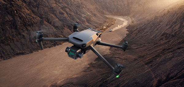
DJI Mavic 3 has better sensor, dual-camera system, omnidirectional obstacle sensing, smarter flight modes and longer flight times
Mavic 3 drone. (Image: DJI)
The new DJI Mavic 3 is an update of the company’s folding camera drone, providing comprehensive improvement and boosting performance for aerial photography.
The Mavic 3 has improved navigation and obstacle sensing systems. A powerful positioning algorithm improves hovering precision with signals from GPS, GLONASS and BeiDou satellites. This enables Mavic 3 to lock onto multiple satellite signals faster. The increased positioning precision also makes the drone less likely to drift in the air and more stable when shooting long exposures and time lapses.
For its obstacle sensing system, Advanced Pilot Assistance System (APAS) 5.0 combines inputs from six fish-eye vision sensors and two wide-angle sensors, which seamlessly and continuously sense obstacles in all directions and plan safe flight routes to avoid them, even in complicated environments.
The obstacle-sensing system also enables more intuitive subject tracking with the upgraded ActiveTrack 5.0. Previous iterations of ActiveTrack enabled the camera to follow a subject as it moved directly toward and away from the drone while remaining largely stationary as well as fly alongside a moving subject. ActiveTrack 5.0 allows Mavic 3 to move with the subject as it moves forward, backward, left, right and diagonally, and fly alongside as well as around a moving subject.
If the subject moves too fast and temporarily goes out of frame, visual sensors on the aircraft will continue to track and frame the subject intelligently and pick it back up when it reappears. These new directions enable much more fluid and diverse drone and camera movement while using ActiveTrack.
Other safety features include geofencing, which alerts drone pilots when they fly near sensitive locations; altitude limits to ensure pilots are aware of altitude restrictions; and the AeroScope Remote ID system that allows authorities to identify and monitor airborne drones in sensitive locations.
Mavic 3’s integrated AirSense system, first widely introduced in DJI Air 2S, warns drone pilots of nearby airplanes and helicopters transmitting ADS-B signals, so they can quickly fly to a safer location.
Hasselblad camera
Mavic 3 has a 4/3 CMOS Hasselblad camera and 28x hybrid zoom camera. Omnidirectional obstacle sensors have a 200-meter range, and redesigned batteries provide up to 46 minutes of flight time.
Upgraded hardware and software can process 5.1K video at 50 frames per second and support 4K/120 fps for high-quality results for slow-motion footage. An enhanced Mavic 3 Cine edition offers Apple ProRes 422 HQ encoding for richer video processing, with an internal 1TB SSD onboard for high-speed data storage.
DJI Mavic 3’s customized L2D-20c aerial camera embeds a professional-grade 4/3 CMOS sensor with a 24 mm prime lens in a sleek and compact form. Rigorous Hasselblad standards for hardware performance and software algorithms allow it to shoot 20-MP still images in 12-bit RAW format and videos in 5.1 K at 50 fps and 4 K at 120 fps. The higher video definition creates smoother footage and more generous cropping possibilities and allows for slow-motion video at 120 fps.
The larger image sensor gives Mavic 3 higher video resolution and dynamic range and more effectively suppresses noise in low-light environments. A native dynamic range of 12.8 stops helps retain more details in highlights and shadows, preserving rich visual information with a greater sense of depth and elevating imagery to a professional level. An adjustable aperture of f/2.8-f/11 is available to meet the needs of aerial photographers in a wide variety of lighting scenarios to get sharper and clearer images.
Sand Studio, a mobile device management (MDM) solution provider, is offering AirDroid Business Geofencing, a location-based solution for businesses to monitor and track device location, automate tasks and receive notification alerts in one place.
With geofencing, organizations that have vehicles, personnel or valuable assets in the field can use tracking data and workflows to enhance security and optimize operational efficiency.
Geofencing integrates seamlessly with AirDroid Business’ easy-to-use yet powerful device management solution, enabling IT managers to apply different configurations to existing or newly created device groups at any time.
Adding to the existing location tracking feature, AirDroid Business Geofencing brings new capabilities like geofencing, path tracking, automated workflow, logs, and notification management.
Geofencing: Location-based technology where a customizable virtual fencing zone can be created for devices that are coming in and out of a predefined area on a map. Single devices or groups of devices can be added to multiple profile zones for different scenarios, which provides flexibility and more control over deployed devices.
Path Tracking: Admins can track a device and see its extensive path history. This allows for an in-depth analysis by combining time and location. For instance, admins can track a delivery truck and see if it has deviated from the assigned route, analyze the data, and improve operational efficiency.
Workflow, Logs and Notifications: Workflows work together with geofences. Triggered by a device entering or exiting a geofence, workflow will activate automated tasks such as device locking and factory reset. Working side-by-side with workflow is log management, where point of time, device activity, device status and events can be filtered to spot abnormal activities or insights for improvements.
“With mobile transformation continuing to take place in every industry, more businesses and organizations are deploying mobile devices in the field. However, they are also faced with the challenge of managing these devices,” said Anson Shiong, CEO of Sand Studio. “To help with this transition, AirDroid Business’ focus on remote device management and the new geofencing solution will help businesses maintain security and operational efficiency. These new features are designed to monitor and track remote devices with precision from anywhere in the world.”
Geofencing is beneficial to a range of industries such as medical and health institutions, public agencies who need to track people at risk in situations like the coronavirus outbreak, transportation and logistics companies that need specific details on fleet activity, corporations that disseminate company devices with confidential information, food delivery services and more.
The new tracking capabilities ensure consistent employee productivity levels as well as enhance security by knowing where the employees and devices are while also enabling confidential materials to be remotely wiped from a device when outside of the safety zone.
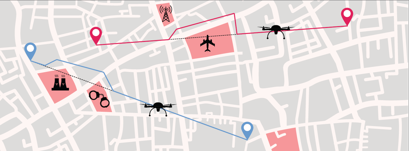
Thales is leading the SESAR Joint Undertaking to research and develop new services for safe, efficient and secure access to airspace for drones.
The SESAR Joint Undertaking (SESAR JU) supports the European Commission’s U-space initiative by researching and developing new services for safe, efficient and secure access to airspace for an expected increase in drone use.
The Geosafe project is part of the founding services for the development of drones operation. Thales will manage the project, supported by Aeromapper, AirMap, Atechsys, Airmarine and SPH Engineering.
The 280 flight tests with 16 different drones will be conducted in France, Germany and Latvia. These tests will explore all possible situations that an automated drone will face in urban and rural areas.
By securing the flight pattern of drones to avoid determined zones, geofencing solutions are key safety enablers. Geofencing ensures that drones don’t fly in protected perimeters around critical infrastructures, such as power plants or airports.
The objectives of Geosafe are to establish state-of-the-art geofencing solutions regarding U-space regulation and to propose improvements and recommendations for future geofencing system definition.
Geosafe will be based on a one-year-long flight-test campaign, assessing a number of commercially available geofencing solutions so that it can propose an improved geofencing system and technological improvements for automated drones.
Thales designs systems ensuring high security and safety levels for future air mobility. As the leader of the project, Thales will organize all tests and provide recommendations for the European geofencing system.
“Thales is playing a leading role in shaping the autonomous world,” said Christian Bardot, Thales VP in charge of Helicopter and UAV Avionics Business. “Together with SESAR JU and the Geosafe partners, we will strengthen the foundations of drones’ safe and secure operations, unleashing the potential of this tremendous market.”
GIS is growing in importance to urban development, whether for environmental impact studies, geofencing or building information modeling (BIM). Sharing GIS data with developers is critical to a coordinated approach to smart city growth.
By Christine Easterfield, Principal Analyst, Cambashi
Just over half the world’s 7 billion population lives in cities. In Europe, this rises to three quarters, and 30 cities worldwide have populations of more than 10 million — the majority in India, China and South America.
This trend will continue. It is projected that the global population will reach almost 10 billion by 2050, which means cities will need to cope with increasing demands on housing, transport and communications.
Growing urban populations place considerable stress on housing stock. Cities need to provide scope to build new, but also to look at best use of existing properties.
In the growing urban population, there will always be a proportion that needs more support as employment rates shift and wages do not always keep up with city expenses. Social housing projects need to keep pace, and making the most of city resources opens opportunities for smart buildings.
The role of GIS
Proposed Indianapolis zoning map. (Image: City of Indianapolis)
Coordinating new build and refurbishment plans across a city requires planning and organization, and a set of tools to support planners and designers. The layout of city-planning zones is the starting point for many new developments — sharing data about these areas is typically achieved using a GIS (geographic information system).
The standard city map with records of roads, emergency routes, bike routes, key buildings, new development zones, existing housing stock, utility services and street lighting are a central resource for most cities.
Sharing data between these city maps and developers’ plans is critical to a coordinated approach to city growth.
Environmental impact
The early stages for many developments involve an environmental impact study. How will the new development fit into the existing landscape? What restrictions are imposed because of the conditions of the site or the current demands on local resources? What options are there for addressing these constraints?
This last point is important for acceptance of the development. Being able to show a level of flexibility to accommodate local concerns and developers’ challenges will build a cooperative relationship. The ability to easily integrate building plans with the city map means that confidence is quickly built into the new plans.
Combining the geography of the city view with the building model destined for development provides a perfect foundation for an integrated GIS/BIM model to take the development from drawing board to handover.
Maintaining a digital twin of a development, in the form of a BIM, provides a rich source of information about the as-built building — exact measurements, materials used, changes from the original design and more. Integrating this with the city maps held in GIS means a continuous dataset can be formed.
Tools for construction site inspection and reporting
Photo: Alen Ajan/Fotolia.com
Developing building information models (BIMs) requires monitoring the build activity and accurate recording of the construction. The best way to do this is as it happens.
Simple-to-use tools that are robust enough to cope with a construction site are becoming more available from software providers. These support gathering data by construction teams and contractors as the work is completed.
As well as recording data, these tools are also useful in registering the progress and completion of tasks. Many enable interaction with central systems that can send changes and updates directly to the site for immediate action.
The same tools can register the location of the user, enabling safer working practices to be enforced.
The practice of geofencing to monitor or even restrict access to parts of a construction site, by registering the location of a device against a predefined region on a map of the site, can track critical activities and react with the most appropriate action if an incident is reported.
Remote site inspection and reporting
The Aeryon SkyRanger. (Photo: Aeryon Labs)
The safest inspections don’t involve human intervention at all. Sending an unmanned aerial vehicle, UAV or drone, to fly over your site removes risk to staff when viewing hazardous environments.
Photographic imagery collected by drone can be loaded into GIS tools and accurately registered against the map of the area to provide a seamless view of the site.
Data integration is key
The range of data that can be accurately gathered and viewed together now covers original 3D designs, 2D construction plans, inspection photo-imagery and as-built updates.
Integration of BIM and GIS tools means that these different data types can be viewed together and in the same spatial context.
Support for building operation, management and maintenance in the wider context of a smart city
On-the-spot data capture of accurate as-built building information models that can seamlessly integrate with existing city plans leads to a data resource that cities can build on to improve safety, security and facilities for their citizens.
So what should the smart city planner be looking for?
Existing geospatial and data management tools already address many of these challenges, and when an opportunity for a technology refresh is presented, the approach to smart city support should be a big part of the mix.
Christine Easterfield
Christine Easterfield is principal analyst for Cambashi. She has more than 20 years’ experience in the software business. Her experience has covered geospatial asset management for the utility industry: assessing market needs and opportunities, managing customer requirements, liaising with development teams and running global product introduction programs.
Previous roles include programming, training, consultancy and product marketing management.
She has worked for a range of companies from multinationals to small start-ups, resulting in an understanding of how different sized organisations operate, grow and manage change. Christine has a BSc in Computational Sciences and an MA in English Literature.
Streamlined application and 30-minute response improve unlocking process.
DJI’s Matrice 200 drone. (Photo: DJI)
Drone maker DJI is introducing improvements to its geofencing system. Professional drone pilots with authorization to fly in sensitive locations can now use a streamlined application process to receive unlocking codes within 30 minutes.
DJI’s geofencing system uses GPS and other navigational satellite signals to automatically help prevent drones from flying near sensitive locations such as airports, nuclear power plants and prisons. These improvements are carefully designed to help expand the beneficial uses of drones in sensitive areas that have been restricted in DJI’s geofencing system.
While those areas will remain restricted to more casual drone pilots, DJI now staffs its global authorization team around the clock in order to process applications and provide unlocking codes quickly.
Professional drone pilots can apply to unlock restricted zones at www.dji.com/flysafe/custom-unlock. This portal page allows pilots to easily enter information about their aircraft and controller, as well as authorization documents supplied by the controlling authorities in areas where they wish to fly.
Enterprise users can for the first time include multiple aircraft in a single unlocking request.
“DJI now processes most requests within 30 minutes, though requests involving unusual circumstances or requiring additional documentation may need additional time,” said Michael Perry, managing director of North America at DJI. “By making it easier for authorized pilots to put drones to work in sensitive areas, DJI is once again showing why professional drone operators choose our aerial platforms for the most important tasks.”
“DJI first implemented geofencing in 2013, and it is now established as an important tool to help our customers make thoughtful flight decisions, while also addressing legitimate concerns about safety and security by helping prevent unauthorized flights in the most sensitive locations,” said Brendan Schulman, vice president of policy & legal affairs at DJI. “These improvements illustrate DJI’s ongoing commitment as the industry leader to continually improving the safety features we implemented years ago, while enabling beneficial applications for our technology.”
For more information about how enterprises are using DJI products to work safer, faster and more efficiently, visit enterprise.dji.com.
Comtech Telecommunications Corp. has launched Location Studio, a versatile service platform for mobile operators, application developers and enterprises to build or enhance cloud-based, embedded and hybrid applications using a modular set of location-based services (LBS) tools.
Location Studio incorporates multiple technology suites that provide a broad range of functionality, allowing developers to create location enabled applications with contextual awareness, including:
GeoSuite for integration of maps, search, geocoding, routing and navigation. Also includes geofencing for triggering alerts when devices enter or exit a specified space, and Comtech’s Trusted Location solution for verifying and validating a device’s location to prevent fraudulent activity.
PositioningSuite, a powerful engine that can locate and track assets, such as IoT devices, seamlessly switching between inside and outside environments while minimizing device power consumption using a proprietary geofence algorithm that eliminates the need for “always on” GPS.
MessagingSuite, a comprehensive, carrier-grade messaging platform that supports virtually all messaging protocols and is capable of supporting personalized high-volume messaging applications for alerts and notifications, such as product and/or services information, emergency alerts, and critical internal communication.
AnalyticsSuite, a web-based portal for reviewing and exploring user, device or application data.
“Location Studio encompasses two decades of location-based services experience that can be easily configured into consumer, industrial or workforce-ready applications and services while minimizing deployment timelines, costs, and resource requirements,” said Jay Whitehurst, president of Enterprise Technologies, Comtech Telecommunications Corp. and member of CTIA’s Board of Directors. “We are excited to see how this new platform influences and enables the use and impact of location intelligence across a number of different markets.”
Location Studio supports both hosted and in-network LBS solutions and provides API’s that can be tailored to meet the specific needs of various vertical market customers, including mobile network operators, automotive OEMs, fleet and logistic organizations, insurance and financial organizations, as well as manufacturers. As part of these solution offerings, Comtech provides project management, coordination and testing support.
Editor’s Note: Comtech placed third in the IoT category for 10th annual CTIA Emerging Technology Award at CTIA Super Mobility 2016. According to the wireless association, the winners represent the latest innovation in mobile products and services that have the power to transform networks, businesses, smart cities and connected consumers. Newell Thompson, vice president, Category Marketing, Technology & Telecommunications, Time Inc. presented the winners at the live awards ceremony at the Sands Expo.
“CTIA Emerging Technology Award winners represent the best mobile products, apps and services of the year that have the potential to influence and benefit businesses and consumers,” said CTIA Show Director and Conventions AVP Heather Lee. “Marking the tenth year of this distinguished awards program, CTIA is honored to once again recognize companies that are raising the bar of excellence for mobile innovation.”
A panel of 35 industry experts and analysts judged submissions across 15 award categories to determine the finalists and winners. The “Crowd Favorite” was determined by a popular vote of CTIA Super Mobility 2016 attendees and online visitors.
Drone-maker DJI has launched a public beta version of its new geofencing system in North America and Europe.
Geospatial Environment Online (GEO) will provide drone users with up-to-date guidance on locations where flight may be restricted by regulation or raise safety or security concerns. With this major upgrade to DJI’s existing geofencing system, users will have access to live information about areas temporarily restricted from flight due to forest fires, major stadium events, VIP travel and other changing circumstances.
The GEO system will also show restricted areas around locations like prisons, power plants and other sensitive areas where drone flight would raise non-aviation security concerns.
To accommodate the large variety of authorized applications, GEO will allow drone operators with verified DJI accounts to self-authorize and temporarily unlock flight in some locations. Certain areas where drone flight is not allowed, such as Washington D.C., will remain as unlockable no-fly zones. Unlocking requires a DJI account verified with a credit card, debit card or mobile phone number. DJI will neither collect nor store the information, and the service is free.
The verified account is required only if a user chooses to fly in a location that might raise aviation safety or security concerns.
Use of GEO requires a drone firmware update and installation of a beta version of the DJI Go app.
The Smart Energy Catalyst. The project showcased how a smart home, smart electric vehicle and smart energy system can work together in an IoT ecosystem with location as a key interaction point.
Geospatial technology company Esri was honored at the TM Forum Catalyst InFocus event for the company’s contributions to developing solutions for a more connected world. TM Forum, a global industry association for digital business, presented Esri and partners with the Most Innovative Catalyst Award.
“We’re driving toward the ultimate Internet of Things (IoT) ecosystem where you can bring different applications together that are going to make our lives safer, more energy efficient, and much better in the future,” said Randy Frantz, telecommunications solutions director at Esri.
Esri’s telecommunications team collaborated with Orange and BearingPoint on the award-winning proof-of-concept project called the Smart Energy Catalyst. The project showcased how a smart home, smart electric vehicle and smart energy system can work together in an IoT ecosystem with location as a key interaction point.
The multiphase project examined the infrastructure necessary to support a smart energy ecosystem. With the latest iteration of the Catalyst, the project team demonstrated how geofencing in homes and cars can work with Esri’s geographic information system (GIS) technology. When the consumer leaves home or work, mobile devices trigger the GIS to initiate a series of notifications and actions. For example, lights in homes automatically turn off, security systems are enabled, and users are notified that their electric vehicle needs charging.
“Location provides context to the IoT network. It transforms raw sensor data into useful, actionable information,” Frantz said.
TM Forum’s Strategy Committee gave the award to the Smart Energy Catalyst team based on several criteria, including having a compelling and inspiring demonstration; growth potential and business value; and potential for humanitarian or other positive effects on society.
Nearly 200 industry leaders attended the Catalyst InFocus conference, where they explored the organization’s 11 project demonstrations.
TM Forum’s Catalyst program connects diverse companies from across industries, facilitating collaboration and fostering the cocreation of innovative solutions to pressing telecommunications business challenges. Catalysts are member-led projects and demonstrations that both inform and leverage TM Forum best practices and standards including TM Forum Frameworx.
The organization announces Catalyst Awards biannually. Winning teams leverage proven technologies, competencies, and investments. Teams have six months to develop proofs of concept that outline digital solutions.
In addition to his work on the Smart Energy Catalyst, Frantz accepted a position earlier this year as colead of TM Forum’s IoT work stream. The endeavor explores how location, advanced sensor and device data, and powerful industrial and consumer solutions can change social norms and bring business into the modern technology framework.
TM Forum includes more than 900 member organizations and 85,000 individual members.
The AL3RT asset tracker is designed for the power sports industry and runs on the AT&T network.
Kika Enterprises announced at CTIA Super Mobility this week that its AL3RT asset protection unit will be available as an accessory for Polaris electric bikes worldwide, beginning January 2016. The AL3RT trackers will be sold at sports dealerships in the United States.
Powered by AT&T, AL3RT is a stand-alone, customizable asset locator and fleet management tool designed for theft protection of on- and off-road vehicles, motorcycles, snowmobiles and personal watercraft.
AL3RT customer benefits include: real-time location alerts, anti-theft alerts, accident panic alerts, historical location data, coverage in locations around the globe, long battery life (up to seven days) and a water- and dust-proof housing. The product line will also include several accessories, such as a multi-use cradle for easy mounting and Bluetooth multi-sensors that can be programmed individually.
Supported by GPS, GSM, Wi-Fi and Bluetooth technologies, users can use their AL3RT smartphone app to locate their asset, as well as arm and disarm sensors and configure geofences virtually anywhere in the world. AL3RT can be configured to send individual or group alerts via email or SMS.
“We are excited about the launch of the AL3RT, because it represents the first true anti-theft alert solution designed for the power sports industry,” commented Ricardo Salguero, president of Kika M2M. “The AL3RT offers superior features, reliability and AT&T connectivity, making it a tremendous extension of our growing line of customizable M2M solutions. This addition truly positions Kika M2M uniquely in the market with a broad range of proprietary M2M solutions for the power sports industry.”
Kika M2M will showcase the AL3RT at CTIA Super Mobility, taking place Sept. 9-11 in Las Vegas, as a part of AT&T’s Booth #3724.
With Exelis RangeVue, a high-performance GIS visualization engine provides real-time updates of critical operational elements.
Exelis has signed agreements with four Federal Aviation Administration (FAA)-designated unmanned aircraft systems (UAS) test sites for airspace situational awareness and research. The research will focus on using the Exelis Symphony RangeVue sense-and-avoid tool towards safe integration of unmanned aircraft into the national airspace system.
Under the terms of the agreements, the test sites will gain valuable real-time and historical situational awareness of the range airspace via Symphony RangeVue, while Exelis gains critical product feedback through operational usage. Participating test sites are:
Pan-Pacific UAS Test Range at University of Alaska, Fairbanks
Northern Plains UAS Test Site at University of North Dakota
Northeast UAS Airspace Integration Research Alliance at Griffiss International Airport, N.Y.
Mid-Atlantic Aviation Partnership at Virginia Polytechnic Institute
“The partnerships with these test sites are win-win arrangements,” said Ed Sayadian, vice president of Civil & Aerospace Systems for Exelis. “The test sites receive air traffic control quality surveillance data, increasing safety and enabling beyond-line-of-site operations, while Exelis gains critical product feedback, which will be used to shape and validate our service offerings.”
Symphony RangeVue enables UAS operators and test range personnel to have access to both real-time and historical aircraft surveillance information via a web-hosted platform, helping to manage mission operations across multiple locations.
Symphony RangeVue can be used as command center decision support and post-event analysis tool, or in the field as a sense-and-avoid addition to UAS ground control stations. Flexible geo-fencing tools alert operators when a UAS approaches airspace boundaries or other aircraft are in the vicinity.
Additionally, Exelis is pursuing research and development opportunities with the test sites exploring detect-and-avoid algorithms; non-cooperative target tracking; command and control systems; infrastructure inspection and monitoring; big data analysis for air traffic; and integration of non-FAA surveillance sources. Exelis will leverage capabilities across multiple test sites for a wide range of operational testing and collection of safety data.
This year’s Mobile World Congress in Barcelona was the biggest ever, with 95,000 attendees and thousands of booths, conferences and people with sore feet walking a cavernous exhibition hall. While the Geneva Auto Show ran close to the same dates, connected vehicle companies and technology were prominently featured. What was interesting, however, was the rise of indoor positioning companies and mobile advertising agencies with interest in location.
BARCELONA — Joining the 95,000 or so Mobile World Congress attendees were about three dozen companies who are offering indoor location and location advertising services. These companies have exhibited at previous conferences, but not in the numbers this year.
At the huge Fira convention center where MWC was held March 2-5, Los Altos, Calif.-based Pole Star installed more than 600 beacons for indoor location. Visitors were able to be guided to booths and other areas through an interactive map. “Business was good in 2014, we sold 10,000 beacons. We are making money,” said Christian Carle, Pole Star CEO.
One analyst said that the big change at MWC wasn’t the number of indoor positioning companies and demos, but the maturity and breadth of the technology. “Intel announced indoor positioning capabilities in their Wi-Fi chip, and had a demo that was very impressive. Many smaller companies that in past years were showing raw technology were showing polished solutions this year, such as Quuppa, MTI and Sensewhere, said Bruce Krulwich, Grizzly Analytics president, who has authored a report identifying 150 indoor positioning companies. “I definitely see a shake-out coming up, but it won’t be one technology prevailing over another. Different technologies meet different needs in the industry, and different technologies fit different sites. There are technologies that deliver universal indoor positioning, without any infrastructure or preparation, such as Wi-Fi multilateration and sensor fusion.”
Krulwich said that there is a shake-out that’s already started because there are too many companies working on similar technologies. “Start-ups in the area that don’t have differentiating innovation, don’t have integration into retail or other back-end systems, and don’t have market penetration, are already finding themselves in a challenge. But companies with clear innovations and commercial deployments will do fine,” he said.
United Kingdom-based Sensewhere is using crowdsourcing in its indoor positioning software. The software uses radios to scan for Wi-Fi and Bluetooth to allow an IP location to reference the sources and form a location database.
“It’s what we call the universal indoor positioning versus venue specific indoor positioning, which can work anywhere — we just need a crowd of people. Our target partners are handset manufacturers, network operators, social media, social network providers, and also chipset guys as well,” said Rob Palfreyman, Sensewhere CEO. “So, there are obviously a lot of companies like Google looking at venues; there is Micello and TomTom looking at add-ins in the indoor location, which is great news, but it just needs to have a technology that can drive the blue dot on their map, and we feel that Sensewhere is the right place to provide that blue dot because of the crowdsourcing global nature of our approach.”
One company, which has developed a popular mobile game, is using its network to attract advertisers for its location-based ad platform. “We already have the infrastructure in place because of our mobile game. With our platform, we can allow advertisers to launch campaigns using our beacon signals and geofencing,” said Pedro Jahara, CEO of Brazil-based RevMob.
New location technology like the ability to track SIM cards was rolled out at MWC. W-Locate, which is partnering with Morpho in Thailand, is tracking SIM cards with its XimLoc product, which the company said is more accurate indoors than other technology.
Even such companies as Geotab, which is a strong player in the fleet market, are leveraging MWC to continue a foothold in the European market. The company displayed its IOX-CAN system that can send data from a mobile device to the MyGeotab system, which can be viewed an analyzed by fleet managers, said Maria Sotra, Geotab marketing manager.
Geotab also partnered with Telefonica in November 2014 to focus efforts in Spain, Germany and the United Kingdom, Sotra said.
At MWC, location-based advertising market is gaining traction as advertisers are seeing the benefit of locating and attracting customers. New York-based xAd said it has doubled its revenue for the second year. “We have billions of mobile ads processed and billions of ad impressions. The company is profitable,” said Dipanshu Sharma, xAd founder and CEO.
He said the company has expanded into France and Germany and added China to its global ad network.
Another company that is using location technology as a differentiator is Airpush, which had another big presence at MWC. The company’s Abstract Banners was a big draw to attendees. Location, particularly geofenced areas, have created a call to action for consumers, which is attractive to advertisers, said Cameron Peeples, Airpush vice president of marketing.
Connected Car Still Big Opportunity at MWC
Although the Geneva Auto Show was starting as the MWC was ending, there were still several big announcements by connected car companies in Barcelona. Even the well-publicized Samsung S6 and S6 Edge and HTC One M9 handset rollouts included Mirrorlink, the connected vehicle standard from the Connected Car Consortium.
In another big announcement, Audi and AT&T said that all 2016 model vehicles equipped with Audi connect will come with the carrier’s 4G LTE or 3G coverage. This increase in services is big because the auto giant just rolled out 4G AT&T service in Audi A3s last year.
AT&T selected Airbiquity to provide end-user registration and device management connected vehicle services for select customer programs. “Airbiquity will deliver these services to AT&T using our Choreo cloud-based connected vehicle services delivery platform and project management, engineering, and operations teams,” said David Jumpa, Airbiquity chief revenue officer. “This is a ‘white label’ agreement whereby AT&T will integrate Airbiquity’s service delivery capability into AT&T’s connected vehicle customer solutions.”
Another location company is making huge inroads in connected vehicle markets with its Glympse for Autos product. Glympse will be installed in select Volkswagen and Peugeot models through MirrorLink, said Bryan Trussel, company co-founder and CEO.
The app allows users to share location from their vehicle by setting the recipient and timer, and hitting send. The company has a similar app for Gogo inflight aviation networks to allow a person on the ground to know where an airplane is for picking up passengers.
In other connected car news, Accenture is providing Fiat Chrysler Automobiles the capability of in-car, Internet-based services. Starting with the new Fiat 500X, Uconnect Live services, which was co-developed by Accenture, will power an infotainment system that offers music and news services, social network access, the ability to monitor driving style and a range of diagnostic services.
Accenture also partnered with Visa for an IoT-based connected car commerce test. At MWC, the company tested a scenario where drivers could order food from the car using cellular, Bluetooth and beacon connectivity. Accenture deployed a similar system with BMW’s ConnectedDrive, which allows customers to choose services in real time for a vehicle.
Health Market Even Has Location Potential
Niche location applications are growing as Internet of Things, or IoT, markets start to grow. One company taking advantage of the mobile market is Annapolis, Md.-based TCS, which featured its VirtuMedix platform in its MWC booth.
The platform is tailored to emergency physicians as part of the growing market for video telemedicine products and mobile health, said Jay Whitehurst, TCS commercial software group president. “It’s already saving lives,” he said of the platform, which combines encryption, navigation, mapping and messaging.
While the product, now being rolled out in a North Carolina emergency medicine group, provides patients with an alternative to urgent care centers and emergency rooms, it also can be used for longer term cases such as assisted living and rehab centers, the company said.
Whitehurst said TCS has made several company acquisitions that have played a part in new product rollouts, which include the company’s Trusted Location. The application allows financial firms, online gaming companies and others to identify and prevent credit-card fraud. The application identifies and validates a device’s location worldwide.
In other Mobile World Congress news:
Spirent said its simulators have the capability to evaluate Wi-Fi Offload and Wi-Fi performance of mobile devices on its test framework. The new product allows companies to test multiple devices on a single unit to cover Wi-Fi/LTE mobility and interoperability. The testing is important in light of wireless carriers’ strategy to extend VoLTE in areas where cell coverage is limited, said Saul Einbinder, Spirent vice president, venture development.
Google Waze said its Google Mobile Service (GMS) will be available as a preinstall option on mobile devices. OEMs and carriers can preinstall the app on their handsets so consumers can use the service immediately, the company said.
Trimble’s ALK said its ALK Maps and route visualization software is now available in Europe. ALK Maps, launched in the United States in 2012, allows users to overlay routing, geocoding points, weather and other features, the company said.