LoJack Corporation is collaborating with Novatel Wireless to develop robust positioning and accuracy capabilities in the LoJackConnect for Inventory Management system. The system helps sales personnel at dealerships accurately track and actively monitor vehicle inventory across multiple lots, helping to minimize the time required in the regular dealer inventory process. Accessible via computer, tablet and mobile phone, users can verify vehicle location, access relevant vehicle information, track test drives and receive early warning alerts if a vehicle is moved from a geofenced location.
LoJack Connect for Inventory Management is powered by the Novatel Wireless 3060 OBDII solution for HSDPA/GSM/GPRS. The MT 3060 is a specialized OBD II telematics solution that offers advanced technology and a sophisticated feature set, combined with high quality and compatibility testing standards, Novatel Wireless said. With dual accelerometers, GNSS support, an open platform, and the N4A Content Cloud Management System, the MT 3060 enables LoJack to offer a reliable telematics solution to dealerships nationwide.
Computer security company Absolute Software Corporation is extending its products to use Google Maps to provide improved device geolocation tracking in its Absolute Computrace product. The partnership will provide Absolute customers with improved global coverage and more accurate geolocations.
“The location of a device is an important factor in assessing the risk of a data loss event and measuring compliance with corporate policies. The accuracy of the geolocation data we present in our products is critical to our customers,” said Bill Gordon, vice president, engineering and development at Absolute Software. “Using Google Maps technology allows our customers to track devices and be alerted of risks with the highest accuracy.”
The geolocation capabilities of Absolute Computrace include recent and historical location information for a device, as well as the ability to build geofences to contain devices within a specific geographical area. If a device goes beyond the bounds of a geofence, IT is alerted so they can investigate and determine if the device and the data on it is at risk.
“Our customers rely on our solutions to provide timely and accurate information regarding the health and safety of their endpoints and the data they contain,” said Geoff Haydon, CEO of Absolute Software. “Google Maps will ensure we are delivering the most accurate results, from every device, for all of our customers worldwide.”
A number of factors are holding the proximity marketing/indoor positioning markets back: standardization issues, consumer acceptance/privacy, retailer awareness and the technology itself. However, as one location executive put it, it may be the one way that retailers with brick and mortar stores can compete with Amazon and other online giants.
Indoor location and proximity marketing may be the way large and small brick and mortar stores can compete with online retailers in the future, said panelists at the New York Place conference, held July 22. But all of this indoor location market talk doesn’t mean much if consumers don’t find a need for it.
“I am in an aisle at a grocery store and you sent me a coupon for cat food, and I don’t have a cat, I am not going to be interested. The retailer gets to own the data by providing a great experience to the consumer, not the spontaneous ‘you are in a store — here’s some information,’” said John Dempsey, Datalogix head of mobile and video.
While having a broad picture of a consumer’s “mobile moment” is important, there is something to be said about bombarding a consumer with too many location-based applications, said Doug Kilponen, Wanderful Media chief operating officer. “There are a limited number of apps consumers are willing to have, but not 200 different ones. It’s one thing to have an app for say, Target, but trying to find out what is broadly available during shopping makes shopping too much work,” he said. “Trying to find out what’s available becomes too much work as there are too many options [for the consumer].”
From a retailer’s perspective, they want consumer’s data, and will share it with partners, but they also want control, said Catherine Lindner, Shelfbucks chief marketing and merchant officer, who was an executive at Walgreens. “If you think about your own shopping behavior, there is only a few places you actually go to and spend money — a grocer, drug store. That retailer wants your data, and it makes sense,” she said. “How do we spend the money to grow the business? The idea that there is one bucket of money to transfer is not going to happen.”
One company says that consumers don’t want to be “advertazed” by retailers. “Their job is to show you Calvin Klein, but sometimes there is not enough information or context. They hijack moments, rather than create them,” said Scott Townsend, Urban Airstrip director of agency programs.
Still, retailers are increasingly using indoor location as part of their mobile strategies. Jewelry chain Alex and Ani has three beacons in their Boston and New York stores, said Ryan Bonifacino, Alex and Ani vice president, digital strategy. “We really want to prove that this [indoor location] can really work. We really want to get in front of people who wouldn’t have discovered us,” he said.
Indoor Location Standardization? What Standardization?
Like any new technology and market, industry standardization will have growing pains, and a lot of the problem may be with the retailers, said panel members. “There are issues with standardization. If Walmart puts a [indoor positioning] in to its store — they don’t care if it works anywhere else,” said Don Dodge, Google developer advocate.
Indoor location is the classic chicken-before-the-egg situation, said Chris Goodall, Trusted Positioning founder and CEO. “There currently are no standards for indoor [positioning], maybe we need it. Databases are not standardized,” he said.
A lot of the reason that standardization has not be resolved is that no big application, the old killer app, has appeared. “Indoor is something that has not emerged yet, it’s a long tail story,” said Dan Ryan, ByteLight co-founder and CEO. “Every location company is trying to build a network — and naturally attract developers.”
Making Proximity and Indoor Location Relevant to Retailers
Some retail chains like Walgreens have used indoor positioning technology for years and are considered some of the major early adopters. However, making consumer-purchasing behavior data relevant to retailers is the only way for indoor marketing to take off.
The concept of geofencing each store has been tested in several locations. One company envisions an image of a celebrity greeting consumers in a store with an offer. “Walgreens focused on not invading people’s privacy. But they basically asked users, what’s important to them when they walk into a store,” said aisle411 founder and CEO Nathan Pettyjohn. “[Bluetooth Low Energy] beacons can do this very elegantly. When a consumer walks through a store, perhaps they see a celebrity popping out to greet them.”
In many successful mobile marketing campaigns, all have a common theme — proximity components always enhance sales, said James Smith, Verve chief revenue officer. “Every one of our studies says it drives sales. Sometimes we hear that geofences don’t work — my answer to that is they are in the wrong places,” he said. “A person can go into a place 15 days later and a beacon locks on them — the retailer is happy because it works. Consumers are more empowered because they have a research device in their hand to go where they want to go.”
Case Study: Walkbase
A Finland-based company is delivering market research to retailers that examines consumers’ in-store shopping behavior and loyalty patterns. Walkbase, which signed a deal with Helsinki airport operator Finavia, started in 2007 when it spun off from an indoor location company.
“It’s a retail tool that analyzes indoor performance of marketing campaigns and [sales] conversion. It measures when consumers come into a store — do they bounce out or are they engaged?” said Juha Mattsson, Walkbase vice president, sales and marketing. “A retailer can launch a campaign that is affected by a consumer’s indoor journey. Whether that is through coupons, or not, as some retailers don’t want that.”
Mattsson says that the company is operating primarily in Europe — and is waiting for what indoor technologies will win. “It is just a matter of time before the market takes off. Retailers are very interested in these types of consumer spending analytics,” he said. “We will be launching a U.S. white paper on in-store optimization as it’s all about education. We also are rolling out a version 2.0 of our product in the third quarter.”
In other LBS news:
According to published reports, Michael Halbherr, CEO of Nokia’s HERE mapping unit, will be stepping down. Halbherr, who is based in Berlin, steps down after eight years at the company. As recently as 2012, HERE, then called Navteq, had been losing money but had stabilized recently. Cliff Fox, HERE senior vice president, will be acting CEO until a replacement is found.
I will be covering CTIA’s Super Mobility Week in Las Vegas, Sept. 8-11. To arrange an interview with me for Wireless LBS Insider, or to submit press releases, contact me at [email protected].
Everbridge has launched a Summer Release of its Unified Critical Communication Suite with new mobile, GIS, and expanded alerting enhancements that enable Everbridge customers to deliver unified critical communications and situational intelligence within the context of their recipient’s needs, roles, and locations.
As enterprise mobility, BYOD, and other unified communications drivers continue to converge in an increasingly global, yet unpredictable world, organizations deploy Everbridge’s Unified Critical Communication Suite to respond and collaborate during both emergency and operational incidents, the company said.
The latest release expands upon the recently launched spring release, offering new features designed to unify multi-modal, critical communications for diverse industries, including corporations, state and local government, healthcare, financial services, and higher education. The summer release includes new updates to Everbridge’s recently unveiled IT Alerting solution — specifically designed for IT Operations teams to improve communications and collaboration during incidents, resolving issues faster, and maximizing IT system uptime.
Additional upgrades to the summer release include:
PrecisionGIS: Everbridge’s rich GIS functionality now includes three new map-based targeting capabilities:
Geofencing: This new feature enables users to draw simple or multiple complex polygons to define boundaries and control the behavior of addresses located inside or outside the “fence.”
Custom Base Maps: Everbridge supports commercial mapping applications, including Google, Bing and ESRI, and now enables organizations to overcome existing gaps with commercial maps by customizing the base map used within the Everbridge suite. The base maps can include the geographical or infrastructure information users need to make more informed decisions when preparing and targeting a message.
Point-Address Geo-Coding: Users can now manage and provision all addresses down to the parcel level to ensure the data is accurate and precise enough for critical communications. This enables an advanced level of custom and granular geocoding capabilities beyond what is available via commercial geo-coding applications.
Rich Text Formatting: The Everbridge suite provides enhanced rich text formatting support for email, enabling users to send the right message to the right contact path. Users can now deliver full-featured, unique messages, including entire web pages without modification, optimized for Phone, SMS, Email, and Push Notification contact paths.
Mobile Enhancements: New mobile device registration simplifies user access and improves Mobile Member opt-in. New enhancements also include “silent mode” override for Android mobile devices to ensure that critical messages get delivered at all times.
On-the-Go Alerting: This new partner functionality enables users to create and transmit customized alert messages directly from an iPad application. Users can draw affected areas directly on a map, while sending and receiving notifications through IPAWS communications channels.
On-Call Scheduling: Everbridge now provides robust on-call scheduling to automate outreach to on-call teams with rotating coverage or complex shift changes. Seamlessly integrated with Everbridge notifications, on-call scheduling eliminates the need for manual call lists and handwritten calendars.
“The new enhancements to our summer release reflect our continuing commitment to product investment and innovation,” said Imad Mouline, CTO of Everbridge. “Our customers are confronted daily with new challenges and opportunities related to mobility, business continuity, emergency notification, secure messaging, and more. We will continue to evolve our suite to meet these challenges—unifying critical communications across modalities and devices on a global scale.”
The U.S. Patent and Trademark Office has issued 10 U.S. patents to TeleCommunication Systems, Inc. during the second quarter of 2014. TCS also received two foreign patents during the quarter.
The 10 U.S. patents describe innovations in messaging, location-based services, GIS/mapping and wireless. They include the following three:
TCS reported in the first quarter that it was issued a Prepaid Short Messaging Services patent. In the second quarter, TCS received notice that another prepaid patent was issued to the company that will serve as one of the cornerstone patents in a monetization program that TCS is planning to launch later this year. The prepaid market has grown into a multibillion-dollar per year industry, with 86 million prepaid users comprising 27 percent of all U.S. wireless users, according to a J.P. Morgan 2013 market report. The recently issued Prepaid Short Messaging patent (U.S. 8,738,496) is a continuation of earlier TCS prepaid patents, bringing TCS’ prepaid messaging portfolio to eight, with one additional pending. Most prepaid phone systems allow users a prescribed amount of prepaid messaging and wireless call time. The ‘496 patent describes techniques for determining if a recipient’s account is sufficiently funded to receive a message. If it is not, the system prevents the delivery of messages until the recipient’s account is sufficiently funded, when follow-on messages will be delivered.
A geofence defines a virtual spatial boundary for creating triggers when a mobile device either enters or exits that boundary. Geofences are commonly used in child location services to alert parents when a child’s mobile device leaves the boundary of a school or park, or by enterprises to track the location of a mobile workforce or equipment. Establishing a geofence can be complicated, requiring that the user manually draw the boundary on an electronic map. The recently issued TCS patent covering a Method and System for Identifying and Defining Geofences (U.S. 8,731,813) describes techniques to simply and easily create geofences based on real-world objects or places. Using the map/navigation application on a mobile device, the user simply selects the desired location, using its pre-defined boundary to create the geofence.
Thousands of portable computing platforms have emerged that have the capability of directly connecting to the Internet either through a wireless wide area network (such as cellular network or campus Wi-Fi network) via a front-end built into the device (smartphone, etc.), or, via Bluetooth or other short-range wireless communication, to a wireless proxy device such as a modem or a smartphone. With various low-cost, short-range wireless devices installed in vehicles for navigation or entertainment purposes, it has become increasingly important to provide an easy and efficient method for a motor vehicle manufacturer, parent or other authority to monitor and control access to certain sites when those devices are connected to the Internet. The recently issued Remotely Provisioned Wireless Proxy patent (U.S. 8,712,408) describes techniques to create white lists (allowed URLs) and black lists (disallowed URLs) within a wireless/mobile device acting as a proxy so that access to certain sites can be controlled effectively.
The remaining seven U.S. patents issued in the period are: Integrated, Detachable Ear Bud Device for a Wireless Phone (U.S. 8,688,174); N-Dimensional Affinity Confluencer (U.S. 8,688,087); Login Security with Short Message (U.S. 8,712,453); Intelligent Reverse Geocoding (U.S. 8,731,585); Secure Location Session Manager (U.S. 8,687,511); System and Method for Location Assurance of a Mobile Device (U.S. 8,718,673); and Wireless Network Tour Guide (U.S. 8,744,491).
CompassCom will offer Esri User Conference attendees a sneak peek at advanced asset tracking capabilities in the upcoming version of its CompassTrac software powered by Esri ArcGIS technology. Scheduled for release in late summer, CompassTrac 6 provides Esri users with custom digitizing tools for geofencing applications and map optimization for any electronic device.
CompassCom will demonstrate the new CompassTrac 6 capabilities in booth #2307 at the Esri User Conference, being held July 14-18 in San Diego.
“The newest version of CompassTrac will enable Esri GIS users to keep track of their vehicles and high-value assets with greater ease than ever before whether they are in the office or out in the field,” said CompassCom CEO W. Brant Howard. “On-the-fly geofence alerts increase fleet efficiency and improve crew safety.”
CompassTrac is the software tool that enables Esri ArcGIS users to view the locations and statuses of vehicles and other high-value assets on their GIS map in real time. Leveraging existing Esri architecture and GIS data files, CompassTrac locates addresses and displays vehicle positions, speeds, and heading on the fly using selected ArcGIS data layers as the map background, including satellite and aerial imagery, the company said.
Over the past 16 years, CompassTrac has provided field service management services for thousands of vehicles operated by organizations involved in public safety, public works, utilities, road maintenance, delivery and transportation.
The premier upgrade to CompassTrac version 6 is a set of digitizing tools that allows the user to draw a geofence polygon around any feature or area — a street, neighborhood or town — on the GIS map. If any vehicle or asset being tracked by the system crosses the geofence boundary, CompassTrac will automatically send a text or email alert to select users and highlight the vehicle in question on the map display. These geofence alerts occur instantly and on the fly in real time, providing enhanced tracking of mobile resources to help operators manage their mobile work force.
Now with version 6, CompassTrac is also hardware agnostic. The software will automatically scale, or optimize, its map view to fit on the screens of desktop computers, laptops, tablets and smartphones, giving Esri users the ability to track assets from any location where they have Internet.
Visitors to CompassCom’s booth #2307 at the Esri User Conference will also view demonstrations of the new CompassLDE Connector, which provides plug-and-play capabilities to link AVL and mobile resource management tracking to the Esri ArcGIS GeoEvent Processor.
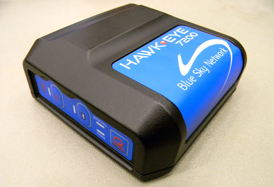
Blue Sky Network’s HawkEye 7200 Portable Tracking Solution.
Blue Sky Network has released the portable HawkEye 7200 with geofencing. The Hawkeye 7200, released in September 2013, is a small mobile device designed specifically for Iridium and GNSS satellite tracking of aviation, land/mobile or marine assets. The company will demonstrate its new AVR (advanced variable response) geofencing capabilities at the upcoming HAI Heli-Expo tradeshow in Anaheim, California, February 25-26.
“Advanced variable response or AVR delivers functionality and utility one level beyond traditional geofencing alarms or alerts. It allows the asset manager or geofence designer to set a conditional response for what happens or does not happen when an aircraft, vehicle, or vessel is in, or out of a geofenced area,” explains John Peterson, Blue Sky Network’s vice president of Business Development. “For example, position reporting frequencies could be turned off when an asset is at its home base, resume normal reporting after leaving the base, and increase reporting frequency when entering regions considered more dangerous. AVR gives asset managers more control, ultimately making fleet management easier, safer, and less expensive.”
In addition to AVR, the HawkEye 7200 offers three significant advantages over traditional satcom asset tracking devices
An all-in-one design including internal long-lasting lithium ion battery and dual Iridium and GNSS antenna;
true concurrent multi-national GNSS for faster, more accurate positioning; and
Bluetooth connectivity using Blue Sky Network’s custom APP for iPhone and iPad, facilitating easy messaging and custom form transmission from Apple devices.
The HawkEye 7200 portable satcom solution works directly with Blue Sky Network’s cloud-based web portal SkyRouter. Skyrouter is a secure online website that provides tracking and management of globally dispersed assets.
AT&T and Sabre, a global travel technology company, announced they will jointly explore solutions that could usher in a more personalized experience for travelers. The two companies are developing and testing solutions that will utilize AT&T’s newly enhanced Location Information Services (LIS) – Hybrid, which allows developers to build geo-aware mobile applications. The companies are exploring how device-based location information services can help airlines, airport retailers, and other travel-related companies deliver intelligent, predictive and personalized services throughout a traveler’s journey.
AT&T LIS Hybrid has the ability to define custom geofences (a virtual perimeter within a geographic area) in any shape or size, both indoors and out, using cellular, GPS and Wi-Fi information shared by the user from their devices. Knowing when a traveler enters or leaves a pre-defined geofence would allow travel suppliers to provide personalized services and relevant offers based on the traveler’s real-time location.
“By applying cutting-edge technologies, coupled with data analytics and better intelligence, we can give travelers the personalized experience they have come to expect in today’s connected world,” said Sarah Kennedy of Sabre Labs, the technology incubator and research lab at Sabre. “Together with AT&T, we will explore the role advanced location-based services can have in helping travel suppliers provide better, more personal service to their customers.”
The app might alert airline staff when a high-status passenger is still clearing security when her flight is due to depart; or notifies travelers of special promotions as they approach an airport bookstore; or warns a passenger if he is in the wrong terminal for his connecting flight. The two companies are exploring technology that could underpin these types of apps across almost all types of smartphones, tablets and operating systems. Any services developed as part of the trial will meet location services best practices guidelines when it comes to customer privacy including customer opt-in.
“Our application programming interface, or API, and software development kit allows companies like Sabre to build multi-carrier geo-aware mobile applications,” said Laura Merling, of AT&T. “AT&T LIS Hybrid works with Wi-Fi as well as existing cellular device-based information location services such as GPS, to deliver near-precise device location information indoors and outdoors.”
Phase one of the pilot project between Sabre and AT&T is expected to be completed during the first half of 2014.
By Miguel Torroja, Steve Malkos, and Christophe Verne
Users of smartphones, tablets, and other devices expect position with the highest level of accuracy, always available, with the least amount of power consumed. One recent improvement fulfilling this demand involves operating-system services for location on smartphones, and the evolution towards lower power solutions.
“Please connect to a charger — The battery is getting low: less than 15 percent remaining.”
Handsets are battery-supplied devices, and a user’s tolerance for features is driven by battery consumption. There are many examples of technologies where users do not run certain hardware or features because it will consume the battery and make the phone useless within a short period of time.
The application processor (AP) of a handset device is very powerful, and is the part that consumes most of the battery life. Today’s smartphone multicore application processor is faster than many desktop computers that are just a few years old. Whatever the application, when it uses the AP, it can draw up to hundreds of milliamperes (mAs).
For the last few years, the trend for GNSS has been host-based positioning. Host-based designs have less logic on the GNSS integrated circuit (IC) and employ the host AP for a portion of the positioning computation. This strategy has three advantages:
Shares memory and code resources with the application processor.
Reduces the cost of the dedicated GNSS hardware.
Sharing the processor makes sense since it is already running.
Traditionally, when the GNSS solution was running, a navigation application that utilized the AP was also running.
However, when we only want to compute GNSS positions in the background, and we do not need a third-party application running on the AP, a host-based IC architecture is not the optimal solution with regard to system power consumption. This article explains some of the technologies used to compute a GNSS position using an ultra-low power (ULP) hybrid solution that combines the classic host-based GNSS architecture with a host-offload architecture that minimizes the use of the AP.
We discuss here two applications that benefit from a host-offload architecture: geofencing and position batching.
We will review the requirements for a platform to support a new hybrid GNSS positioning solution. Different host-offload technologies for geofence, such as GNSS, Wi-Fi, and Cell-ID, will be compared. Broadcom’s ultralow-power host-offload GNSS solution supports any operating system. We focus here on Android’s operating system because it is the most open OS.
Always-on Applications
Geofencing is an application that sends reports or triggers alarms when a predefined area is crossed. For example, users can be alerted to discounts with e-coupons when walking through a mall, or to “don’t forget the milk” — users can set their own reminder notifications based off of location; also, social networking. One example of location-based reminders is through Google Keep, which uses Android’s Geofence APIs on platforms that support hardware geofencing; this application will automatically take advantage of the hardware geofence solution.
Geofencing applications run in the background for long periods of time, and their main task is to compute positions (fixes) without the need of assistance from other applications. An ultra-low-power GNSS position solution, or always-on positioning solution, is desirable for these scenarios. Typical applications require notifications when entering or exiting a geofence area, or require periodic reporting of user positions relative to the fence.
Geofencing is not something new. API support has been provided in mobile OS for many years, but only now can it be used without draining the battery, thanks to this new host-offload architecture.
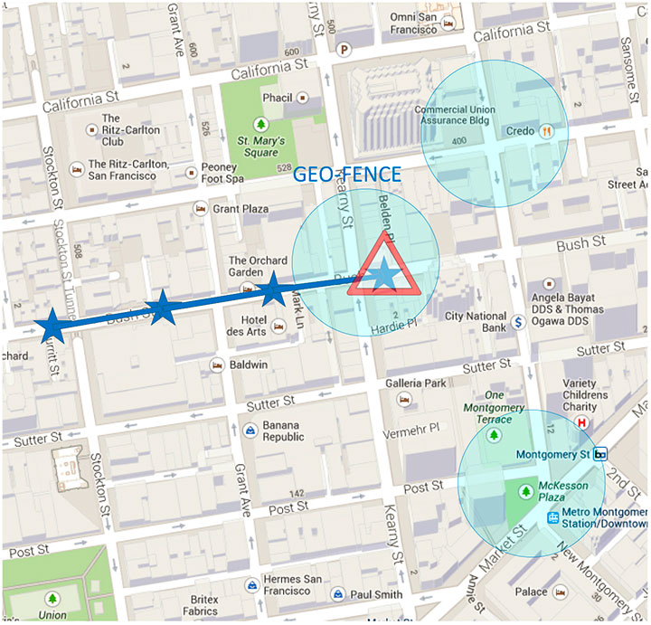
Figure 1 shows a circular geofence boundary and an alarm. In that example, the alarm was triggered when entering the fence.
Figure 1. Alarm when the vehicle enters a geofence area.
Breadcrumbing or position batching pertains to storing of positions, referred to as crumbs, which are accumulated for a certain amount of time and then pushed all at once to the application. Examples would be fleet or asset tracking applications, or people that wants to track their position while they are running.
Currently, Android does not support breadcrumbing as a native feature. There is some ongoing work, and APIs are being defined.
GNSS Positioning Models
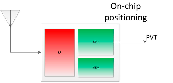
Before smartphones, the dominant GNSS hardware architecture employed a system-on-chip solution. The position/velocity/time (PVT) comes directly from the hardware, and all the computations are done in the GNSS IC.
On-Chip Positioning requires two things: a powerful-enough central processing unit (CPU) and lots of memory. The increase in CPU and memory performance are not free; they translate directly into more power and higher manufacturing costs.
The RF block in Figure 2 is intentionally drawn with a similar size to the CPU and memory, to emphasize the need for higher resources for a complete on-chip solution.
Figure 2. On-chip solution.
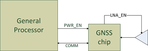
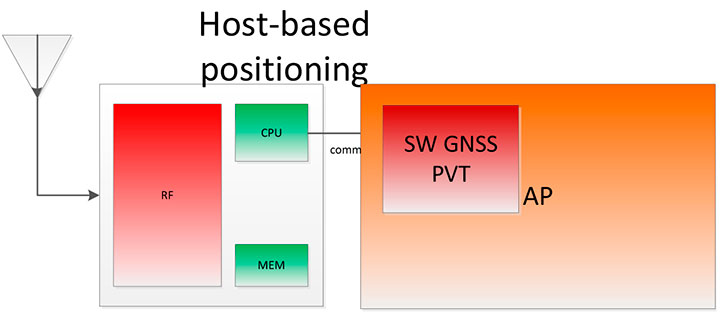
Host-Based Solution. GNSS positioning requires dedicated hardware, complex software, and protocols. This complexity led GNSS providers to move parts of the software out of the IC to the AP.
Using a mobile phone’s AP for position computation is one method of reducing the CPU and memory power footprint from the GNSS IC. At the same time, it also increases the power consumed by the platform needed to compute GNSS position, since part of the computation is not performed on the host-based IC. APs may consume approximately 100 mA just to be operational.
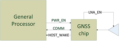
Figure 3 shows a typical configuration with dedicated GNSS hardware and a generic AP. In host-based mode, both the AP and the GNSS IC run in parallel when computing positions. The AP controls the GNSS hardware.
Figure 3. I/O connections in on-host positioning.
With this type of shared architecture, shown in Figure 4, the CPU and the memory on the GNSS IC are reduced, shrinking the size of the chip and reducing power consumed by the chip. In Figure 4 we see that the AP is communicating with the dedicated hardware, and the final PVT is computed by the AP. This solution fits well in many applications, such as navigation, where the AP has to run a mapping application at the same time.
Figure 4. Host-based solution.
Hybrid Positioning. For geofencing, we need a hybrid model, one which keeps GNSS IC complexity similar to the host-based architecture, but also offloads some of the host-based positioning so that the host can go to sleep.
In Broadcom’s hybrid mode, the AP does not need to run when GNSS positions are computed. Broadcom’s hybrid IC does not invoke the host AP often, and thus achieves an even lower power footprint. The CPU on the GNSS IC used for computing position is a dedicated one. It needs to be carefully chosen because it has to be powerful enough to compute positions and be as power efficient as possible. All this is done while keeping the GNSS IC area size in mind, to control cost.
Detailed analysis and steps were considered to ascertain the minimum requirements for the CPU and other resources to best accomplish the on-chip positioning task.
Other considerations: the GNSS IC must be powered even when the AP is suspended, and the GNSS IC must be capable of waking up the AP. Figure 5 shows a possible implementation using a dedicated I/O signal controlled by the IC to wake up the host AP.
Figure 5. I/O connections in hybrid positioning.
With this architecture, the host AP will still be needed to provide some assistance data to the GNSS IC. The assistance provided allows the GNSS IC to not invoke the host AP often and thus achieve an even lower power footprint.
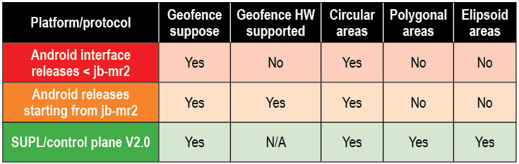
Geofencing Methods
Certain OS application APIs have been supporting geofencing for many years. Currently, we can find geofencing APIs in most of the mobile OSs in the market.
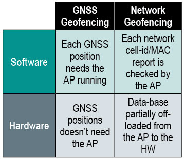
There are four main types of geofencing: GNSS software geofencing, GNSS hardware geofencing, network software geofencing, and network hardware geofencing (Table 1).
Table 1. Geofencing methods.
GNSS Hardware Geofencing. In this method, the one described in detail in this article, the OS initiates a request and offloads the areas of interest to the hardware. After that, the AP can go to sleep and the hardware is responsible for computing positions and checking the areas of interest. This method basically relies on GNSS hardware to compute positions and check the programmed fences.
GNSS Software Geofencing. Here, the OS initiates regular fixes to a host-based GNSS IC design. Then it invokes both the AP and the GNSS IC at the same time to check against the defined fence areas.
Network Geofencing. In this method, the OS requests network IDs from the hardware (that is, baseband modem Cell-ID and Wi-Fi access points). The OS uses different positioning technologies to compute position. This usually requires a connection to a server to retrieve location information about the different IDs. The position is used to check the geofences.
In network hardware geofencing, a set of network IDs is offloaded from the OS to the network hardware ICs. The hardware can poll for these IDs, and wake up the host when found.
Network versus GNSS Geofencing
A good geofencing solution combines both network and GNSS methods because each solution benefits from each other.
GNSS positioning solutions compute positions in open-sky environments with accuracy to a few meters and have worldwide coverage. However, they cannot work in deep indoor spaces.
Network geofencing using cell IDs is quite inaccurate, but works very well indoors. Network geofencing using a Wi-Fi access point provides reasonable accuracy, but location of the access points is not always known and it does not have full coverage.
Geofencing in Android 4.3. The API for applications supports geofencing. Starting from the first version of Android, the application just initiates a proximity alarm and will get an event when its boundaries are crossed. The OS is responsible for notifying the application when such an event occurs, and can use any technologies it sees fit.
The API that applications use is very simple. The monitoring is handled by the OS and is hidden to the application (for example, technologies, periodicity of checks, and accuracies).
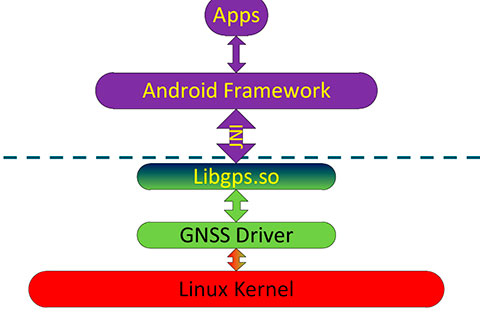
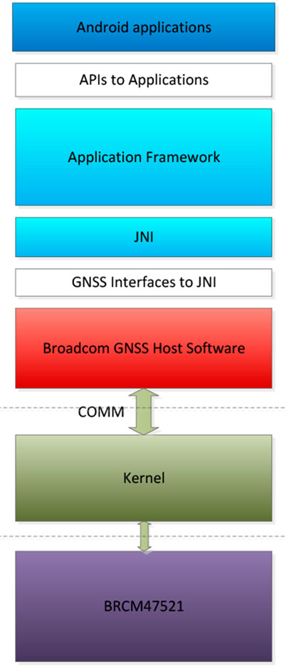
Software Geofence in Android. Software geofencing has been the default method until recently, as there was no native hardware support. In this mode, the host-based GNSS positioning engine is started like any other position request. The Android framework is the one dealing with the monitoring of the geofences, and therefore, the AP must run continuously to handle periodic position checks. That means the software-geofencing logic is mainly in the framework layer of Android (see basic layers diagram shown in Figure 6).
Figure 6. Android framework.
More recent versions of Android dropped the support for software-based geofencing in favor of a host-based GNSS system, likely because of the big impact on the battery. Broadcom developed a low-power GNSS hardware solution for geofencing.
Hardware Geofence in Android. Starting from Android 4.3, a new interface is available to use hardware geofencing. This interface is not visible to the application, and it is only used as a low-level interface. To support the new hardware-geofence interface, the native driver only has to register to a new GNSS interface defined in the native hardware abstraction layer (HAL) of Android.
There are other protocols known to support geofencing. Table 2 provides a short list.
Table 2. Geofencing support on different platforms.
Broadcom Hybrid Positioning
Android defines interfaces to the hardware, referred to as the HAL.
GNSS Host Software. GNSS providers need to comply to the HAL interface, which is at the Java native interface (JNI) level. Below the JNI lies the GNSS host software (Figure 7).
For the host-based solution, the GNSS host software handles most of the heavy computing.
For the hybrid solution, the GNSS host software does some of the heavy computing, but positions are computed inside the GNSS IC.
To support this new hybrid solution, two main changes are required compared to the usual host-based solution, as described below.
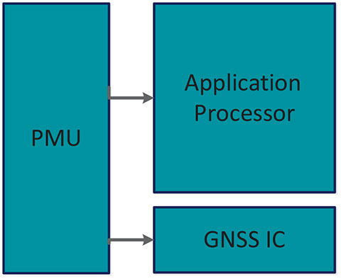
First, the hybrid GNSS IC must be autonomous while the host AP is sleeping. This implies that some power domains are maintained when the GNSS is in use. This typically means at least one of the outputs of the power management unit (PMU) should be dedicated to the GNSS only (Figure 8).
Figure 8. Power domains.
Second, the GNSS IC must be able to wake up the host AP so as to send geofence notifications, or to request assistance data. This is usually done through a dedicated pin.
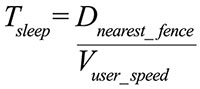
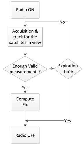
Acquisition and Sleep Period. Most of the power in the GNSS IC is used by the radio and analog part. To reduce power, this part is switched on only during acquisition. As soon as enough measurements are observed, the radio part is switched off while the digital part computes a fix.
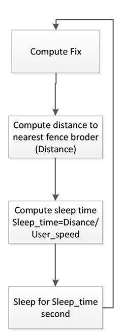
After each computed position, the GNSS IC can go into a deep power-saving mode until the next acquisition. The distance to the closest fence in conjunction with the user speed is used to determine when to compute the next position (Figure 9):
Figure 9. Start fix decision logic.
Once the GNSS IC starts computing positions, the AP can go into sleep mode (Figure 10). Total power per position computed is reduced, and the time between fixes is no longer constant, as shown in Figure 11.
Figure 10. Sleep time between fixes.Figure 11. Duty cycling.
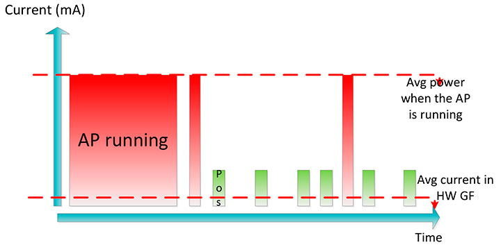
In Figure 12, the lower square-shaped pattern corresponds to a position computation from the hardware GNSS IC. Once we have an alarm, the host has to be woken up and we can see the impact in power in the big peaks after a position is computed.
Figure 12. Power graph.
Alarm Triggering
When a geofence area is crossed, the GNSS IC needs to wake up the AP. This is achieved using a dedicated interrupt pin. After asserting it, an alarm and geofence status is sent to the AP.
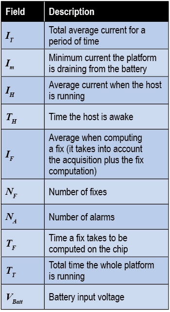
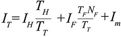
Power Consumption. We calculate the total average current by splitting it into three components, as shown in the following formula:
Some of these parameters are set by the host: for example, how often the fix should be computed. The extra current drained by the GNSS IC is the one defined by
∆I is the change in current drain when computing positions.
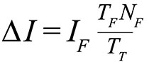
We can also express this formula based on the average number of position attempts:
where Tp is the average time between fixes (the time the GNSS IC stays in sleep).
Table 3 illustrates some theoretical ∆I current savings with respect to Tp.
Conclusion
As APs become faster and faster, their power consumption goes up. A novel hybrid GNSS receiver has been presented, which offloads some of the host-based processing into the GNSS hardware, offering ultra-low system power consumption versus the traditional methods. The new hybrid positioning solution is a good approach for always-on applications that need to have location information always available, without requiring the host to be running, as is the case with geofencing and breadcrumbing.
References
We would like to thank Jason Goldberg, Frank van Diggelen, and Manuel del Castillo, all of Broadcom, who reviewed this article and spent many hours with us discussing the topics point by point.
Miguel Torroja is a principal software developer at Broadcom. He has an M.Sc. in electrical engineering from Ramon Llull University, Barcelona. Since 2011, he has been working on the design and development of algorithms for optimizing power consumption in GNSS host-offload solutions.
Steve Malkos is a senior program manager at Broadcom. He has a B.S. in computer science from Purdue University. He has been active in the development of A-GNSS technologies such as hybrid location services, long-term predicted orbits (LTO), Broadcom’s worldwide reference network (WWRN), and secure user-plane location (SUPL). He has five patents issued and 16 pending.
Christophe Verne is a manager of software engineering at Broadcom. He has an M.S. in electrical engineering from Ecole Centrale, Paris. He has been involved in the development of GNSS and A-GNSS technologies at EADS, Sagem, Global Locate, and Broadcom, where he has been working on low-power host-offload positioning.
Pole Star has launched its new indoor location platform, NAO Cloud. NAO Cloud simplifies the deployment of indoor location solutions by introducing an automated deployment process that dramatically reduces time-to-market and the costs of indoor location-based services, Pole Star said.
NAO Cloud integrates the NAO Campus Software Deployment Kit (SDK), and enables customers and partners to deploy NAO Campus, Pole Star’s indoor location solution, in just a few hours, by using cloud-based software tools as well as positioning databases already available and shared by worldwide partner program members.
In addition, third parties will have access to NAO Cloud’s crowdsourcing capabilities, eliminating field interventions for a simpler, faster and more affordable deployment and maintenance process, Pole Star said. Behavioral analytics or geofencing are also supported by NAO Cloud to maximize the monetization of value added location-based services.
The NAO Cloud platform targets a wide range of businesses such as venue owners, advertising platform providers, application developers, global solution integrators or network operators. NAO Cloud makes deployment, integration in mobile apps and maintenance of indoor positioning services a simple process, from a single venue to a worldwide multi-site coverage, Pole Star said.
“The indoor location services market has reached maturity. Multi-venue owners, marketing agencies and major telcos understand the challenges and the value of hyper-local information and real-time interactions with customers and related Indoor Location Analytics. Indoor positioning is the core technology that brings high value,” said Christian Carle, CEO of Pole Star. “NAO Cloud is the result of years of innovation and deep market experience through very large and complex field deployments around the world.”
In 2012, Pole Star achieved several major innovation milestones, such as the integration of Bluetooth Low Energy and Inertial Sensors in its NAO Campus fusion engine, in addition to Map Data, Wi-Fi and GPS signals. The dynamic combination of these technologies provides today the best indoor location performance results in the market, while addressing any type of building and minimizing network infrastructure, deployment and maintenance costs, Pole Star said.
The NAO Campus solution is now available for more than 80% of the smartphone market, compliant with Android and iPhone devices and embedded in consumer applications on the Google Play Marketplace and the Apple App Store.
Today, Pole Star’s indoor location solutions have been deployed in more than 43 million square feet, in 15 countries such as airports (Paris Charles de Gaulle), shopping centers in Europe and North-America, museums and department stores. In 2011, Pole Star opened its North American headquarters in Palo Alto and has expanded its international presence in 2012, building deep partnerships with companies in Europe, North-America, Asia, Australia and the Middle East. Finally, at the end of 2012, in time for the holiday season, Pole Star launched, its “living lab” mobile application, Mall Buddy, that covers 9 of the biggest malls in Silicon Valley, from San Francisco to San Jose and demonstrates the worldwide extension capability of Indoor location services.
Broadcom Corporation has introduced the BCM47521, a GNSS chip with architecture that enables geofence capabilities while preserving battery life. According to Broadcom, the new chip opens the door to always-on location-aware applications such as social networking, place-based mobile commerce and local merchant advertising.
Broadcom will showcase its GNSS innovations at the upcoming Mobile World Congress show in Barcelona, February 25-28.
A geographical region of interest (“geofence”) is being used by many new and innovative location-aware applications. The geofence feature enables the application to receive a notification when a user enters or exits a virtual perimeter. However, the implementation of this feature in traditional architectures is not viable, as the applications processor needs to run constantly, causing rapid drain to the device’s battery. Broadcom’s new BCM47521 overcomes this issue, making it possible to continuously monitor geofence areas while consuming 60x less battery power.
“The astounding growth of mobile devices is driving new opportunities for inventive applications that deliver valuable location-aware information,” said Scott Pomerantz, Broadcom vice president and general manager, GPS. “With the BCM47521’s low-power geofence mode, Broadcom is driving the next wave of system power consumption innovation that will allow OEMs to incorporate features that differentiate their mobile offerings and make location-aware, always-on applications a reality.”
The BCM47521 chip also provides multi-constellation support by simultaneously collecting data from GPS, GLONASS, QZSS and SBAS, and using the best received signals, resulting in faster searches and more accurate real-time navigation, Broadcom said. Broadcom’s multi-constellation technology, coupled with advanced signal processing, provides faster positioning performance for improved user experience, especially in challenging urban environments where buildings and obstructions can dramatically impact accuracy and time-to-first-fix.
A key feature is the 60x better system power efficiency versus a host-based architecture. An advanced host-offload mode monitors geofences in the background and only activates the applications processor when there is a trigger event, and smart algorithms adapt in real-time as the user gets closer to a geofence boundary.