Seekr has launched the beta testing of SeekrGeo, a geospatial reasoning engine. SeekrGeo provides advanced geospatial intelligence to enterprises and government agencies, accelerating actionable insights with launch partner Wyvern to deliver hyperspectral imaging capabilities.
Wyvern, a hyperspectral imaging and Earth observation data company, provides a comprehensive licensing agreement as Seekr’s inaugural data partner. The alliance accelerates enterprise access to scalable, high-resolution hyperspectral imaging powered by AI-driven analysis that can reason, detect changes over time, and identify meaningful patterns in activity for both national security and commercial use cases including wildland fire management, supply chain intelligence, and countless other actionable VLM-based insights.
As geospatial intelligence (GEOINT) grows to a projected $63B market by 2030, the gap between data availability and usable intelligence continues to widen. Bringing together Wyvern data and Seekr technology fills the gap in the market, giving enterprises and government customers a way to both access multimodal hyperspectral data, and synthesize intelligence and actionable insights with SeekrGeo’s Remote Sensing Foundation Model built for multimodal understanding, contextual reasoning, and autonomous analysis.
“Our first SeekrGeo customers required the use of Hyperspectral imaging to solve the most complex recognition problems. We recognized Wyvern for their best-in-class Hyperspectral LEO constellation and are very pleased to be working with them,” said Rob Clark, Seekr president.
“The biggest barrier to hyperspectral adoption has never been the data, it’s been the difficulty of turning that data into applications,” said Chris Robson, Co-Founder and CEO of Wyvern. “Seekr’s geospatial foundation model changes the equation entirely. Instead of needing months of specialized development work, our customers will be able to build new applications in a fraction of the time at scale.”
DIU accelerates commercial GEOINT and NAVWAR tools and capabilities to the warfighter
The U.S. Defense Innovation Unit (DIU) will be testing ways to mitigate disruptions to GNSS signals this fall.
Disruptions include those from intentional sources, such as spoofing, as well as intentional or unintentional jamming. Intentional tactics can be applied by adversarial nation states, criminal networks or privateers.
The shared interests between the government and private citizens alike for awareness of GPS disruptions make commercial solutions ideal; information and insight can be broadly shared not just within the U.S. Department of Defense (DOD), but across agencies, allied partners and the public as needed.
In the Fall of 2021, the DIU launched the Harmonious Rook prototype project to address the need for scalable, persistent awareness of positioning, navigation and timing (PNT) disruptions across the globe.
This September, the Harmonious Rook team will support the U.S. Army 1st Armored Division’s Command Post Exercise (CPX) at the National Training Center (NTC), Fort Irwin, California. The exercise is focused on large-scale combat operations (LSCO) and intended to stress the division headquarters’ ability to deploy to an austere location and command and control its units utilizing a synthetic training environment.
U.S. and multinational maritime forces participate in SEACAT 2021. (Photo: NTC)
Parallel to this training event is the 2nd Brigade, 1st Armored Division’s external validation exercise, also at NTC, in which the 2nd Brigade will be stressed and evaluated on its ability to deploy while contested and conduct LSCO exercises against a live opposing force.
Several DOD and civilian agencies are participating, including the National Air and Space Intelligence Center (NASIC) and the National Space Intelligence Center (NSIC). Multiple non-traditional vendors and non-governmental organizations are also supporting Harmonious Rook, from data delivery, to machine learning analytics, to visualization and contextualization.
Vendor Participation
Several Harmonious Rook vendors will participate in notable DOD and international exercises. In August 2022, prototyping companies will support the Southeast Asia Cooperation and Training (SEACAT) exercise, where more than 20 Indo-Pacific countries will train and collaborate on the common goal of maritime crises and illegal activities response.
During this multinational exercise, commercial firms will provide space-based geolocation reports and maritime analytical services, and integrate the insights into the U.S. Navy’s and Department of Transportation’s shared visualization platform, Seavision.
DIU is also working to explore the use of publicly available PNT data to draw insight from domestic GPS interference events.
“Mapping GPS disruptions and contextualizing patterns of behavior are key to mitigating the effects of degraded PNT as well as enabling safety of navigation under such conditions,” said Lt. Col. Nicholas Estep, Harmonious Rook program manager, USAF. “Instead of developing, building, and deploying hardware tailored for collection of navigation warfare operations, we are accessing currently available commercial data and analytics to address the need for PNT situational awareness. There are billions of GPS users and devices distributed across the world that may be adversely affected and turning the vulnerability into an advantage for discovery, classification and attribution of such malicious activity is a key aspect of this effort.”
“The Harmonious Rook project is a very promising new approach that complements traditional collection methodologies, as it will help our customers by sharing analysis due to the unclassified and commercial nature of the data,” said Scott Feairheller, senior analyst at NSIC.
“While the Army works diligently to acquire relevant equipment to assist in the real-time recognition and characterization of potential adversary interference, we must leverage non-organic, commercially available software and equipment, like Harmonious Rook, as a stopgap to increase awareness, seize digital key terrain and maximize lethality,” said Lt. Col. Patrick Jones of 1st Armored Division’s Space Support Element (SSE). During the exercise, capabilities will be tested to support intelligence, information operations, and command and control elements with commercial geospatial and navigation warfare awareness at the tactical level.
DIU’s Harmonious Rook program is not limited to the DOD and the malicious activity more commonly observed overseas and in combat environments. DIU is also working to explore the use of publicly available PNT data to draw insight from domestic GPS interference events, a mission with interest from the U.S. civil agencies.
With widespread users and subscribers that rely on PNT services, any intentional or unintentional disruption can lead to severe transportation, communication and financial implications. This highlights the importance of bringing both government and private-sector industries together to identify, attribute and mitigate GPS interference as quickly as possible.
An MQ-9 Reaper on patrol. (Photo: Lt. Col. Leslie Pratt)
Contract to provide geospatial intelligence, infrastructure support and training for the Air Force Distributed Common Ground System
Raytheon Intelligence & Space (RI&S), a Raytheon Technologies business, has been awarded a five-year indefinite delivery, indefinite quantity contract to continue geospatial intelligence (GEOINT) system mission support and training for the U.S. Air Force’s Distributed Common Ground System (DCGS).
Under the DCGS GEOINT Field Support contract, RI&S will provide mission support and engineering services for the current DCGS weapon-system baseline as well as partnering with the Air Force to facilitate the transition to an open architecture.
Open architecture will enable DCGS to more readily integrate data from the intelligence community and commercial providers, with the goal of using artificial intelligence to create multi-intelligence analysis.
DCGS draws in data from airborne sensors aboard the RQ-4 Global Hawk, Mq-1 Predator, MQ-9 Reaper and other intelligence, surveillance and reconnaissance platforms all over the globe.
Under the contract, RI&S will leverage its mission domain knowledge to ensure high mission availability to support end-to-end operations, from mission planning for an airborne sensor to data collection, processing and data discoverability for the DCGS Analysis Exploitation Teams in support of theater and National Command Authority.
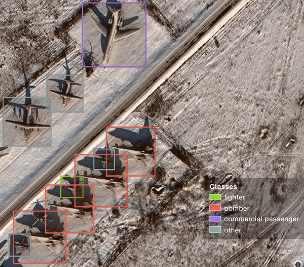
A sample image from Orbital Insights showing classes of military aircraft at a base. (Image: Orbital Insights)
Orbital Insight will integrate Satellogic’s high-resolution multispectral imagery, hyperspectral imagery, and full-motion video into its GEOINT platform
Geospatial intelligence company Orbital Insight has partnered with Satellogic, a leader in sub-meter resolution satellite imagery collection. The partnership will integrate Satellogic’s high-frequency, high-resolution collections of satellite imagery and full-motion video into Orbital Insight’s platform and offer customers better access to high-quality data, improve the revisit rate, and reduce the cost of running analytics.
Satellogic designs, manufactures and operates its own constellation of Earth observation satellites. It has 22 operational satellites in low Earth orbit with plans to launch up to 12 additional satellites by the end of the year. The company aims to expand its constellation to more than 200 satellites by 2025 for daily global coverage of the entire surface of the Earth.
Orbital Insight’s flagship GO platform combines information from the world’s sensors to analyze economic, societal and environmental trends at scale and support activity-based intelligence. Commercial businesses and government agencies use the self-service platform to synthesize answers to critical questions about what’s happening on and to Earth.
Satellogic will provide high-resolution Earth observation data at vastly superior unit economics. This will allow Orbital Insight customers to increase the number of daily revisits on points of interest, see a more granular picture and get deep insights that were not possible before.
“Advanced geospatial analytics require access to high-resolution, high-frequency satellite imagery and simple tasking,” said Kevin O’Brien, CEO, Orbital Insight. “Satellogic is disrupting the industry with a cost-effective, vertically integrated business model. This approach aligns well with our philosophy of making geospatial intelligence efficient, intuitive, and simple so that our customers can get timely insights, make critical decisions, and respond faster.”
“Our mission is to enable greater access to critical Earth observation data. Working with Orbital Insight extends our reach, making our data available to more customers across diverse fields who need to know how the world around them is changing,” said Emiliano Kargieman, CEO and co-founder of Satellogic.
Up to five-year contract follows a successful pilot program that demonstrated the value of commercial RF geospatial intelligence
HawkEye 360 has been awarded a contract by the National Geospatial-Intelligence Agency (NGA) to help the agency discover, characterize and map activities that emit energy in the radio frequency (RF) bands of the electromagnetic spectrum.
HawkEye 360 specializes in RF data and analytics from space-based satellites.
HawkEye 360 will provide NGA the means to develop global datasets, enabling users to discover and monitor a broad range of RF activity across large geographic areas.
The $10 million one-year contract includes an option for four more years. It will support users throughout the NGA enterprise, including the combatant commands and other mission partners.
HawkEye 360’s data will support a variety of analytics missions for NGA, including military activity and the trafficking of military, nefarious, non-state and transnational criminal (or illicit) activity. The company’s growing constellation of satellites will provide insight into developing events in a timely manner, and the company will work collaboratively with NGA on an ongoing basis to effectively meet the agency’s mission needs.
“We’re pleased to be moving from the pilot into an NGA long-term operational contract, which showcases the value of unclassified, shareable commercial RF insights,” said HawkEye 360 CEO John Serafini.
“This program is an excellent example of agile acquisition rapidly delivering high-impact GEOINT to the warfighter,” said Alex Fox, the company’s executive vice president for business development, sales and marketing.
NGA leveraged a National Reconnaissance Office commercial integration study contract with HawkEye 360 in September 2020 to execute a test and evaluation contract with the company.
NGA then issued a competitive RFP in March 2021 and awarded the contract in July 2021. “We are excited to continue working with NGA to address current mission requirements and expand the RF GEOINT tradecraft to address an even larger set of mission requirements, much like NGA has done with their pioneering use of commercial imagery,” Fox said.
HawkEye 360 operates a constellation of nine RF-monitoring satellites. Twenty-one additional satellites are fully funded and scheduled for launch in 2021 and 2022. Once complete, this baseline constellation of 30 satellites will provide collection revisits as frequently as every 20 minutes.
Following the establishment of the baseline constellation, HawkEye 360 plans to launch a second-generation constellation of 30 additional satellites by 2025 to satisfy projected capacity and operational requirements.
The company’s RF data and analytics produce actionable insights for national, tactical and homeland security operations, maritime domain awareness, environmental protection and a growing number of new defense and commercial applications.
The USGIF Awards Program annually recognizes the exceptional work of the geospatial intelligence (GEOINT) tradecraft’s brightest minds and organizations pushing the community forward.
Award winners are usually recognized at the annual GEOINT Symposium. This year’s event, scheduled for April 26-29 in Tampa, Florida, was canceled because of the COVID-19 pandemic.
“Unfortunately, you will not see the awardees recognized on the GEOINT Symposium stage this year,” said Kevin Jackson, chair of the USGIF Awards Subcommittee. “So please take a moment to read their accomplishments and join me and the USGIF in congratulating the 2020 USGIF Achievement Awardees and the runners-up.”
Award winners are nominated by their colleagues and selected by the USGIF Awards Subcommittee.
“The 2020 USGIF awardees reflect the importance and the significance of the outstanding work that occurs daily in the GEOINT community,” Jackson said. “You will see how the GEOINT community always rises to the occasion to face head on the world’s toughest problems and this year is no exception.”
Academic
James Martin Center for Nonproliferation Studies, Middlebury Institute
On Dec. 7, 2019, after denuclearization negotiations between the United States and North Korea collapsed, North Korea reversed commitments made in Singapore and resumed engine testing at its Sohae Satellite Launch Center. Using new technological opportunities offered by high-cadence moderate resolution satellite imagery and flexible high-resolution satellite image tasking provided by Planet Labs, analysts at the CNS, through the use of open-source GEOINT, detected and correctly identified preparations for the engine test 39 hours before it occurred. Announcing in advance that North Korea was preparing to violate an international nonproliferation commitment.
Community Support
NGA Expeditionary Operations Office
NGA’s Office of Expeditionary Operations provides deployed personnel and technology to support GEOINT activities of worldwide U.S. military operations, humanitarian assistance and disaster relief efforts, and other national security objectives. The team’s world-class workforce seamlessly enables trusted global GEOINT capabilities today, while developing programs and processes to meet emerging challenges. Robust partnerships with DoD and IC allies fuel innovation and expertise, helping U.S. and foreign partners build programs that anticipate their needs, expanding the GEOINT community and optimizing meaningful consequence across the GEOINT enterprise.
Government
Mark A. Skoog and Loyd R. Hook
Implementing digital terrain solutions for safer aviation has been a career-long goal for Mark Skoog and Loyd Hook. As true innovators and lifelong proponents of using digital terrain data, Skoog and Hook lead the development efforts of NASA’s award-winning Automatic Ground Collision Avoidance System (Auto GCAS), which prevents imminent collisions with the ground. Auto GCAS is the culmination of a decades-long effort to bring geospatial intelligence to aircraft safety. This work involved traveling the world, evaluating myriad digital terrain from Sweden to Hawaii. The team extensively tested the system to ensure against every category of controlled flight into terrain mishaps—and found it would have prevented every one, which resulted in ten lives saved thus far in the USAF operations.
Industry
Lockheed Martin Space GATR Team
Globally-scalable Automated Target Recognition (GATR) is an artificial intelligence system that finds objects of interest in satellite imagery on a worldwide basis. It was developed by a team of scientists and engineers from Lockheed Martin Space who combined state-of-the-art deep learning algorithms with scalable high-performance computing in a cloud-based framework to achieve high-speed global automated target recognition (ATR). Unlike other ATR systems, GATR searches extremely large geographic regions with accuracy and speed. The GATR team, led by Dr. Mark Pritt, includes Tyler Bartelmo, Gary Chern, Dr. Austen Groener, Michael Harner, Andy Lam, Stephen O’Neill, Ryan Soldin, and Steve Wozniak.
Military
RS/GIS CX, The GRiD Team
David Finnegan and the Geospatial Repository & Data Management System (GRiD) program provide the Department of Defense (DoD), intelligence community and geospatial community with a centralized repository for the storage, discovery, and dissemination of critical terrain and 3D data. Prior to the GRiD program, the National System for Geospatial Intelligence (NSG) lacked a centralized mechanism for the storage and discovery of this essential content. Historically, the data was subject to local storage, limiting visibility and resulting in retasking collection assets for previously characterized areas, putting military personnel and equipment at risk. By partnering with the National Geospatial-Intelligence Agency (NGA) and the DoD, the GRiD program is now the community standard and enterprise solution for 3D/elevation data discovery across the NSG.
USGIF, the United States Geospatial Intelligence Foundation, is dedicated to bringing together the many disciplines involved in GEOINT to exchange ideas, share best practices and promote the education and importance of a national geospatial intelligence agenda. For more on the awards program, visit the USGIF website.
Administered by the National Geospatial-Intelligence Agency (NGA), the mission of IGAPP is to streamline the deployment of commercial mobile apps to government personnel by bridging the gap between traditional government contracting procedures and non-traditional businesses.
Blue Marble’s GIS software is used by hundreds of thousands of mapping professionals throughout the world who need affordable, user-friendly, yet powerful GIS solutions. Users come from a wide range of industries including software, oil and gas, mining, civil engineering, surveying and technology companies, as well as government departments and academic institutions.
Available on both iOS and Android platforms, Global Mapper Mobile enables remote access to mission-critical geospatial datasets in an easy-to-use application. Used in conjunction with the desktop version of the software, Global Mapper Mobile supports hundreds of GIS data formats — both raster and vector — and offers simple, form-based field data collection and geotagged photo capture.
To address the specific needs of the geospatial intelligence (GEOINT) community, the IGAPP version of Global Mapper Mobile includes streaming access to online data services and the ability to store downloaded tiles for remote offline use.
“IGAPP provides mission-relevant, cyber secure mobile apps to warfighters, aviators, mariners and first-responders,” according to John Holcomb, IGAPP program manager at Engility, the NGS’s broker for putting commercial applications into the GEOINT App Store. “The program provides commercial vendors with a rapid, cost effective, path to sell their products. We are thrilled to add the Global Mapper Mobile the store and look forward to getting into the hands of DoD users.”
“Over the years, the GEOINT community has strongly supported our products and has provided valuable feedback that has helped ensure the functionality of our software is addressing the needs of geo-intelligence,” stated Patrick Cunningham, Blue Marble President. “We are delighted that Global Mapper Mobile is now available through IGAPP and that more and more field personnel now have easy access to this valuable app.”
Hexagon’s Geospatial division, which offers high-performance geospatial solutions, showcased its defense solutions at DGI 2019, which took place Jan. 28-30 in London.
DGI is Europe’s largest annual gathering dedicated to high-level discussions addressing the major challenges of the defense and government geospatial intelligence (GEOINT) community.
The theme for this year’s conference is “Source, Analyze, Automate, Share,” and will provide senior defense leaders with opportunities to learn about new developments and innovations in geospatial data gathering and analysis.
Whether for planning military operations, analyzing intelligence or determining responses to a natural disaster, Hexagon’s Geospatial division’s innovations shorten the time between data acquisition and real-time information delivery, driving mission success through actionable decision-making.
Located at stand 8, Hexagon’s exhibition at DGI includes solutions from the Power Portfolio, M.App Portfolio and Luciad Portfolio, which improve data integration, access and delivery across the GEOINT enterprise. The following are some of the innovations that will be on display:
Machine Learning Processes Massive Amounts of Data: Understanding the situation on the ground starts with geospatial intelligence. Attendees will learn how ERDAS IMAGINE’s machine learning algorithms can be trained to process massive amounts of data, taking the load off analysts and freeing them up to do the work that humans do best.
M.App X: Rapidly Exploit Imagery: This cloud-based exploitation for defense and intelligence enables System Integrators to provide tools for the exploitation of imagery and the creation of intelligence and reports for their defense customers.
Command and Control: Providing true situational awareness in action, Luciad offers 2D and 3D integration of all data into one visualization tool, including full support for symbols and tactical graphics of the latest military symbology standards.
“With the traditional battlefield expanding beyond land, sea, and air to the electronic, cyber, and social media arenas, today’s global defense and intelligence agencies operate in high-stakes environments where mission success comes down to accessing, analyzing, and sharing real-time visualization data,” said Mladen Stojic, Hexagon’s Geospatial Division president. “We look forward to showcasing our cutting-edge data analytics and visualization solutions that enable success in today’s multi-domain frontier at DGI 2019.”
Hexagon Geospatial’s Director, Defense Sector, Tony Wheeler will also give a presentation on “A Tiered Approach to Analysis — Enabling the COP User,” on Tuesday, Jan. 29, from 2 to 2:20 p.m. The session will explore how technology can enable military staff to better exploit information — creating a new tier of analytical capability to augment that of dedicated intelligence organizations.
Synthetic aperture radar (SAR) imagery from Maxar’s MDA RADARSAT-2 satellite will become available to SecureWatch subscribers on Oct. 1, according to DigitalGlobe.
SecureWatch, DigitalGlobe’s cloud-based geospatial intelligence (GEOINT) platform, will now combine the company’s high-resolution optical imagery and MDA’s SAR imagery in one platform, enabling defense and intelligence analysts to deliver actionable insights to decision makers regardless of weather and light conditions, the company said.
Maxar’s MDA will refresh hundreds of global sites on a weekly basis using RADARSAT-2’s Wide Ultra Fine format (3 meter resolution, 50 kilometer scene width).
RADARSAT-2 imagery allows users to observe features and changes that go undetected using other imaging techniques, and provides day and night coverage regardless of weather.
SecureWatch users can access timely RADARSAT-2 imagery using current subscription plans. When combined with 30 cm optical imagery, analysts will have an even more uniquely powerful and reliable toolset to perform analysis to make decisions with confidence, the company said.
“Adding RADARSAT-2 imagery to SecureWatch is a perfect demonstration of Maxar Technologies’ unique promise: create valuable, integrated and innovative solutions that address customers’ critical challenges,” said Mike Greenley, group president of MDA. “MDA’s RADARSAT-2 information has played a key role in supporting security missions for over two decades, and partnering with our sister company, DigitalGlobe, immediately enhances our offerings and expands our global reach.”
“SecureWatch subscribers now have an exciting new tool to enrich GEOINT gathering and decision-making,” said Dan Jablonsky, DigitalGlobe president. “Combining SAR and optical imagery takes analysts’ abilities to the next level to deliver powerful insights into what’s happening in their areas of interest and allows them to save lives, resources and time.”
According to the foundation, this is the largest amount it has distributed to date. The scholarships are distributed annually to doctoral candidates, graduate students, undergraduate students and graduating high school seniors.
In addition to the scholarships, two awards are funded entirely by USGIF organizational members: the $10,000 Reinventing Geospatial Inc. (RGi) Scholarship for Geospatial and Engineering and the $10,000 Ken Miller Scholarship for Advanced Remote Sensing Applications. The RGi Scholarship is awarded to an undergraduate student pursuing engineering and geospatial disciplines who demonstrates financial need, and the Ken Miller Scholarship is awarded to a graduate student studying remote sensing who plans to enter the defense intelligence workforce.
“Scholarship winners were selected following a highly competitive, multi-tiered review of applications by GEOINT professionals who volunteered their time as part of USGIF’s Scholarship Subcommittee,” said Dr. Camelia Kantor, director of academic programs at USGIF. “We were impressed with the quality of applications and very pleased to see the next generation of GEOINTers—from the high school to doctoral level—already tackling major world challenges not just by using state-of-the-art technology, but also by applying creativity, logic, attention to detail, innovation and ethics.”
The 2018 USGIF scholarship winners include:
RGi Scholarship for Geospatial and Engineering
David Runneals, Northwest Missouri State University
Ken Miller Scholarship for Advanced Remote Sensing Applications
Joshua Michael Turner, North Carolina State University
Doctorate
Katherine Cavanaugh, University of California, Los Angeles
Jaclyn Guz, Clark University
Carolynne Hultquist, Pennsylvania State University
Christopher Olayinka Ilori, Simon Frazier University
Scott Pezanowski, Pennsylvania State University
Graduate
Jacob Fuson, University of Wisconsin-Madison
Cesar Jhonatan Garrido Lecca Rivera, University of Redlands
Travis Meyer, Pennsylvania State University
Andrew Ryan, George Mason University
Sarah Spalding, University of Texas at Austin
Undergraduate
Jake T. Burstein, University of South Carolina
Milovan Dakic, Indiana State University
Margaret Hackney, Mercyhurst University
Haley Kathryn King, George Mason University
Candice Lee, University of Georgia
Pearl Leff, Macaulay Honors College at Hunter College & Lander College for Women
Claire Mercer, Ohio State University & Sijal Institute
Rachel Pierstorff, University of Denver
Graduating high school seniors
Alexander Chrvala, Towson High School in Towson, Maryland; now attending the University of Mary Washington
Srijay Kasturi, South Lakes High School in Reston, Virginia; now attending the University of Maryland
Madyson Larson, Xenia High School in Xenia, Ohio; now attending the University of Cincinnati
Christopher Lee, Dripping Springs High School in Dripping Springs, Texas; now attending the University of Texas at Dallas
Keelin O’Hara, Albermarle High School in Charlottesville, Virginia; now attending the University of Mary Washington
Adam Wallace Potter, Oak Park River Forest High School in River Forest, Illinois; now attending Massachusetts Institute of Technology
Brandon Staple, Longmont High School in Longmont, Colorado; now attending the University of Colorado Denver
Maxwell Thorpe, David H. Hickman High School in Columbia, Missouri; now attending the University of Wisconsin-Madison
Since the USGIF Scholarship Program began in 2004, the foundation has awarded more than $1.2 million to students with aspirations in GEOINT. USGIF is a nonprofit educational foundation dedicated to promoting the geospatial intelligence tradecraft and developing a stronger GEOINT Community among government, industry, academia, professional organizations, and individuals who develop and apply geospatial intelligence to address national security challenges.
Under the grant, TCarta will enhance and automate multiple techniques for deriving seafloor depth measurements from optical satellite imagery.
The Project Trident research seeks to transform existing satellite-derived bathymetry (SDB) techniques by using machine learning and computer vision technology to enable accurate depth retrieval in variable water conditions.
If successful, these enhanced bathymetric techniques will improve operations related to oil and gas exploration and production, coastal infrastructure engineering, environmental monitoring and geointelligence activities, the company said.
“Our goal with Project Trident is to expand the geographic scope of SDB in shallow coastal areas,” said Kyle Goodrich, TCarta president. “SDB technology currently derives water depths only in calm, clear waters, which limits its applicability.”
Beta testers sought
TCarta is seeking beta testers for participation in Project Trident research. If you are interested, contact Project Trident Principal Investigator Kyle Goodrich at [email protected] or complete the online Project Trident survey.
TCarta won the grant for Project Trident in partnership with jOmegak of San Carlos, California, and DigitalGlobe of Westminster, Colorado, in Phase 1 of the NSF Small Business Innovation Research program.
The one-year research project will be carried out at the TCarta facility in Denver.
In 2014, TCarta successfully commercialized a proprietary technique for digitally extracting water depth measurements down to 20 meters from high-resolution DigitalGlobe WorldView satellite imagery.
The SDB products became popular with organizations operating in shallow coastal waters because the technology is more cost-effective and timely than traditional airborne and ship-borne bathymetric methods — with no adverse effects on the environment, the company added.
“In the current SDB process, we use manual stereo photogrammetry methods to measure seafloor ground control points in digital satellite imagery, but this is extremely time consuming,” said Goodrich. “We are developing an automated photogrammetric process to extract a greater number of ground truth points from high-resolution WorldView imagery.”
Project Trident aims to integrate wave kinematics, a technique patented by jOmegak to calculate water depths in shallow waters by analyzing the patterns and speed of waves detected in satellite imagery. Wave kinematics has been applied successfully using Sentinel-2 and WorldView satellite imagery.
“Thanks to the NSF grant, we are taking a giant leap forward on TCarta satellite-derived bathymetry methodologies and aim to exponentially accelerate them with the latest in machine learning and computer vision technologies,” said Goodrich.
Harris Corporation has been awarded three multi-award indefinite delivery/indefinite quantity (IDIQ) contracts with ceilings totaling $1.5 billion to provide the National Geospatial-Intelligence Agency (NGA) with geospatial data services for up to 10 years.
Harris will create, manage and disseminate high-quality geospatial-intelligence (GEOINT) information for use by the U.S. intelligence community and military worldwide under contracts that cover all three areas of NGA’s JANUS program — geography, imagery and elevation.
The JANUS program will contribute to and maintain comprehensive, geospatially accurate databases of the world that can be accessed quickly as intelligence, operational and crisis needs arise.
Harris will use its predictive analytics technology to continuously evaluate the health of NGA databases and to guide the acquisition, creation and integration of all forms of geospatial data. Harris’ cloud-based tools will validate and correct the data — pinpointing locations that require updates.
“Winning JANUS continues our long-standing legacy of providing high-quality, responsive GEOINT and analytics to the intelligence and military communities,” said Bill Gattle, president, Harris Space and Intelligence Systems. “Our analytics technology provides NGA with fit-for-purpose data, reduced production costs and cloud-based access to geospatial products and content.”
Harris is investing in new technologies that improve the speed and accuracy of providing GEOINT products. The company has partnered with the NGA for almost 20 years to provide automated geospatial data processing, data management, and geospatial systems design and development. Harris provides high resolution geospatial data content and products under NGA’s Foundation GEOINT Content Management program, and previously supported the Global Geospatial-Intelligence program.
Hexagon US Federal Also Contracted
The NGA also has selected Hexagon US Federal as a prime contractor on two multiple award, indefinite delivery/indefinite quantity contracts for amounts totaling $1.17 billion for the JANUS Geography and JANUS Elevation contracts.
JANUS Geography. Hexagon’s tasks for the JANUS Geography program will support the creation, conflation, integration and enrichment of Foundation GEOINT data used to produce a comprehensive and seamless dataset for NGA partners and customers.
The creation of this dataset will ensure more accurate and readily available geospatial data for military and intelligence operations as well as disaster relief missions saving time and lives.
JANUS Elevation. As a prime contractor on the JANUS Elevation contract, Hexagon will support NGA’s Office of Geomatics with maintenance to an existing worldwide library of digital elevation models. The effort includes products generated, modified or assessed by the office that are a digital representation of the terrain surface of the Earth.