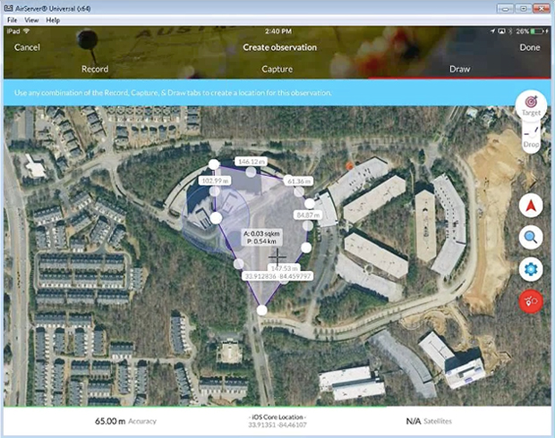
TerraGo, a provider of dissemination and collaboration software for defense and intelligence agencies, has announced the availability of R3 for immediate download in the National Geospatial-Intelligence Agency’s (NGA) GEOINT App Store.
R3 is a mobile data collection and collaboration app customized for the missions of reconnaissance, response and recovery. Designed for the most challenging missions and environments, R3 lets users keep working offline and off the grid with customizable workflows for security, humanitarian and disaster relief programs, the company said.
“R3 enhances situational awareness, search and rescue, damage assessments and recovery efforts,” said Scott Lee, director of federal programs at TerraGo. “It really gives users the best of both worlds with mobile technology that can go anywhere, and will also work even when the network doesn’t.”
Image: TerraGo
Designed with a simplified user interface, R3 provides a robust standalone capability for a variety of field-based collection activities. Users can access custom basemaps from numerous GIS, map and imagery sources including GeoPDF, ArcGIS, USGS and GXP, while collecting and exchanging location-tagged notes using smart forms, photos, videos and audio files.
Pre-loaded forms are available for structured assessments, and users can connect to a secure server to create unique mission packages and enable synchronous collaboration. R3 supports important standards like OGC GeoPackage interoperability and sharing geospatial assets among mission partners.
Registered GEOINT App Store users can download TerraGo R3 for iOS here. The Android version is complete and coming soon, the company added.
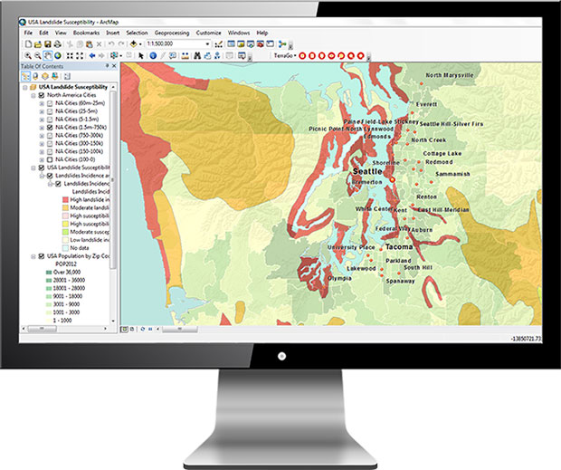
TerraGo has released TerraGo Publisher for ArcGIS version 7.4, which includes the ability to create and share GeoPDFs that convey important changes over time for an area of interest, with any type of map or imagery. The time-enabled visualization can animate geographic changes over time with interactive maps that can be shared with anyone using free Adobe Reader, the company said.
“Our customers can share these time-series map layers as a universally available GeoPDF, enabling non-GIS users to measure past conditions, assess changes over time, analyze trends and even project future scenarios,” said Scott Lee, director of federal programs at TerraGo. “Time-enabled GeoPDFs can help deliver important geographic analysis to the widest audience possible, which is incredibly valuable for sharing information with policy makers, agencies, stakeholders and constituents.”
Time-enabled, interactive maps can be used in any number of different geographic analysis use cases. Here are a few examples.
coastal populations impacted by rising sea levels
progress of recovery efforts for a hurricane disaster zone
forestry and environmental impacts due to policy change
shifting crime patterns in different types of city zones
satellite imagery showing impact of regional military conflicts on local populations
Version 7.4 includes additional enhancements and improvements including support for ArcGIS version 10.6.0.
TerraGo will also be showcasing the latest features at GEOINT 2018, the United States Geospatial Intelligence Foundation Symposium, which takes place April 22-25 in Tampa, Florida.
Teledyne Optech will exhibit at the United States Geospatial Intelligence Foundation’s GEOINT Symposium April 23-25 in Tampa, Florida.
Technology partners from Teledyne Scientific & Imaging, Teledyne DALSA and Teledyne CARIS will exhibit together as part of Teledyne Imaging – Space & Defense in booth 1148.
At GEOINT 2018, visitors can discover the advanced capabilities of the Optech Galaxy PRIME, the latest model of Teledyne’s Galaxy airborne laser terrain mapper, with enhanced range performance, collection efficiency, vegetation penetration and low-reflectance target detection.
The Polaris Terrestrial Laser Scanner (TLS) will be on hand so that visitors can experience its highly automated and user-friendly interface and see its performance at ranges from 1.5 to more than 2,000 meters.
In addition, attendees can learn about the Optech Maverick, the company’s first wearable mobile-mapping system that fits on a backpack.
The Teledyne Imaging – Space & Defense initiative brings together the experience and capabilities of Teledyne Optech, Teledyne Scientific and Imaging, Teledyne DALSA, Teledyne e2V and Teledyne CARIS to expand the breadth of Teledyne Imaging solutions for geospatial intelligence. Representatives of end-user agencies, integrators or original equipment manufacturers (OEM) can visit booth #1148 to learn about a range of new developments and offerings.
The GEOINT Symposium, hosted annually by the United States Geospatial Intelligence Foundation (USGIF), returns to Tampa, Florida, April 22-25.
The annual symposium gathers the defense, intelligence and homeland security communities as well as other users and producers of geospatial information for keynote speakers, panel discussions and breakout tracks offering the opportunity to learn from senior leaders and subject matter experts.
Confirmed keynote speakers include:
Robert Cardillo, Director, NGA
The Honorable Susan M. Gordon, Principal Deputy Director of National Intelligence
Dawn Meyerriecks, Deputy Director, CIA Science and Technology Directorate
Gen. Raymond A. Thomas III, Commander, USSOCOM
A complete list of GEOINT leaders who will be speaking throughout the event can be found here.
GEOINT 2018 is expected to draw more than 4,000 geospatial professionals and well in excess of 200 exhibitors. For complete symposium details, visit www.geoint2018.com.
Hexagon Geospatial will provide students and faculty at each of USGIF’s 14 accredited programs with three-year licenses for its desktop and cloud-based Smart M.App software.
The software is designed to benefit and assist students, professors, and scientists in building geospatial cloud applications.
Smart M.apps are interactive map applications that combine content, analytics, workflow, and presentation to solve a specific business problem.
“As a company with roots in universities across the world, Hexagon Geospatial has always valued students and academia as an investment in the future,” said Jason Sims, Hexagon Geospatial’s chief channel and marketing officer. “This is why we are so happy to announce our partnership with USGIF, providing access to our software and platforms. We look forward to seeing the way instructors, researchers, and students influence how location information will be used to innovate and shape smart change.”
USGIF’s Collegiate Accreditation Program prepares students with the necessary knowledge and skills upon entering the professional geospatial intelligence (GEOINT) workforce. USGIF-accredited GEOINT programs include Fayetteville State University, George Mason University, James Madison University, Universidade Nova de Lisboa, Northeastern University, Pennsylvania State University, the University of Texas at Dallas, the University of Utah, the U.S. Air Force Academy, the University of Missouri, the University of Redlands, the University of South Carolina, the University of Southern California, and the U.S. Military Academy.
“We’re excited about this partnership to collaboratively issue license grants to faculty and students teaching at and attending USGIF accredited institutions,” said USGIF Director of Academic Programs Dr. Camelia Kantor. “USGIF’s accredited programs have a track record consistent with excellence in preparing students for work in the GEOINT profession. Such partnerships bring academia and industry together to ensure the preservation of standards, to encourage innovation, and to enable faculty and students to teach, learn, and conduct research using software from industry.”
A number of geospatial intelligence companies are exhibiting at the GEOINT 2017 Symposium, which is taking place June 4-7 at the Henry B. Gonzalez Convention Center in San Antonio, Texas.
Hosted and produced by the United States Geospatial Intelligence Foundation (USGIF), the annual GEOINT Symposium is the nation’s largest gathering of industry, academia, and government to include defense, intelligence and homeland security communities as well as commercial, federal, civil, state and local geospatial intelligence stakeholders.
The event annually attracts more than 4,000 attendees from all over the world, with more than 250 exhibiting organizations and more than 50 hours of training sessions for attendees.
The theme for GEOINT 2017 is “Advancing Capabilities to Meet Emerging Threats.”
Companies planning to exhibit:
TerraGo will be demonstrating its R3 mobile app, customized for the missions of reconnaissance, response and recovery and built entirely using TerraGo Magic, a zero-code platform that enables customers to build apps tailored to their unique operations with web services, custom map products, imagery, forms and workflows.
Red Hen Systems will showcase its surveillance technology. The company’s Digital Mapping Reconnaissance Toolkit Exportable (DMRT-EX) and MediaMapper Mobile Android app have been used by law enforcement military and civilian members around the world for anti-narcotics operations, vegetation management and other surveillance missions.
Visit Booth 333 at GEOINT to see the company’s equipment in action.
Descartes Labs Inc., a cloud-based geospatial analytics company, will unveil its global-scale machine learning platform. The platform powers geographic and temporal analysis of remote-sensing data to identify objects, forecast change and deliver high-performance intelligence solutions.
GEOINT attendees can learn more about Descartes Labs at booth #1325 in the GEOINT Exhibit Hall. Descartes will also present a Lightning Talk at GEOINT Forward on Sunday, June 4, and a training workshop on Tuesday, June 6.
The Polaris TLS by Teledyne Optech
Teledyne Optech will showcase the advanced capabilities of the award-winning ALTM Galaxy T1000, now featuring a 1-MHz laser PRF, PulseTRAK and SwathTRAK technologies for a universal sensor that surpasses larger systems with consistent, ultra-dense data and measurement precision and accuracy.
In addition, visitors will see the new Polaris Terrestrial Laser Scanner (TLS) for ground-based survey applications. With an integrated high-resolution camera, inclinometers, compass, GPS receiver, and weather-proof housing, the Polaris can be deployed in many environments and orientations.
Visit Booth 1767, where sustaining USGIF Member Teledyne Optech will be joined by Teledyne DALSA, Teledyne Imaging Sensors, and Teledyne Brown Engineering to represent a broader range of Teledyne’s capabilities and solutions for GEOINT/ISR applications, including lidar, EO, IR and hyperspectral imaging.
Esri will be showcasing mission-focused enhancements using the ArcGIS platform for defense, intelligence and national security workflows.
ArcGIS provides high-performance 2D and 3D analysis for defense, intelligence, and national security. It is a complete and open platform for managing, analyzing, and sharing data and data products. ArcGIS leverages big data, web technologies, and integrated apps to make location-based data easy to use, more accessible, and collaborative.
“GEOINT and geographic information system [GIS] technologies have never been more important to the intelligence community,” said Ben Conklin, Esri head of industry, defense, and intelligence. “We are looking forward to the annual GEOINT Symposium, since it gives us a great opportunity to demonstrate the latest advances in GIS technology. The event also gives analysts access to tools that provide quick, responsive, and interactive experiences for increased productivity and support of decision-making and operations at every level.”
Esri will offer the following demonstrations at Booth 615:
Advancing The Science of Where
Reveal Deeper Insight through Analytics
Unlock Your Data with Apps
Open Platform for Intelligence
The Esri Presentation “Geospatial Intelligence Using a Web-Enabled GIS” takes place Tuesday, June 6, 2 p.m., 007C River Level.
East View Geospatial (EVG), a provider of content-rich cartographic products, continues to enhance the accuracy of automated feature identification using its newly developed training data sets in supervised machine learning applications. The early results pertained to automated recognition of building structures in an ongoing pilot project in Papua New Guinea (PNG).
“Our goal is to create a state-of-the-art process that produces the highest quality training data available for the users and developers of supervised machine learning technology,” said Rod Buhrsmith, business eevelopment at EVG. “In just a few months, we have made significant progress and expect to push the accuracy even higher.”
EVG will be available to discuss the PNG pilot in private meetings at GEOINT (contact Rod Buhrsmith at [email protected] or Mark Knapp at [email protected] or call 1-952-252-1205.)
Boundless Desktop is a native, cross-platform desktop GIS built upon open-source software.
Boundless has been awarded a $36 million contract by the National Geospatial-Intelligence Agency (NGA), the primary source of GEOINT for the U.S. Department of Defense and the U.S. Intelligence Community.
The new contract supports NGA GEOINT Services and purchases services required to package, deliver, maintain and patch accredited open-source geospatial software packages.
NGA delivers geospatial intelligence, or GEOINT, that provides a decisive advantage to warfighters, policymakers, intelligence professionals and first responders. Both an intelligence agency and combat support agency, NGA fulfills the president’s national security priorities in partnership with the intelligence community and the Department of Defense.
NGA also is the lead federal agency for GEOINT and manages a global consortium of more than 400 commercial and government relationships.
Boundless offers an open GIS ecosystem through a combination of technology, products and experts that gives enterprises deeper intelligence and insights using location-based data. The Boundless platform is built upon open source technology and open APIs that generate actionable location intelligence across third-party apps, content services and plugins for enterprise applications.
In November 2016, the company extended its GIS platform with Boundless Connect, a subscription service to a comprehensive repository of GIS data, and Boundless Desktop, a full-featured, professional desktop GIS.
“It is great to see an organization like NGA adopting open source GIS,” said Andy Dearing, CEO of Boundless. “So many organizations are quickly realizing the power and flexibility of open source and the value that Boundless brings to market. This announcement further demonstrates the NGA’s commitment to Boundless and we are excited to continue our work with the agency.”
The GEOINT 2017 Symposium, sponsored by the U.S. Geospatial Intelligence Foundation (USGIF), will take place June 4-7 at the Henry B. Gonzalez Convention Center in San Antonio, Texas. The theme of this year’s symposium is “Advancing Capabilities to Meet Emerging Threats.”
Confirmed keynote speakers for GEOINT 2017 include:
Robert Cardillo, Director, National Geospatial-Intelligence Agency (NGA)
James Comey, Director, Federal Bureau of Investigation (FBI)
Todd Lowery, Acting Under Secretary of Defense for Intelligence (USDI)
USGIF will host GEOINT Foreword, its pre-symposium science and technology-focused day, on June 4. GEOINT Foreword brings together government, academia, and industry to discuss innovation and advances in the GEOINT tradecraft. The 2017 GEOINT Foreword agenda includes presentations, poster sessions, a live unmanned aerial vehicle (UAV) demonstration, and keynote addresses by:
Stacey Dixon, Deputy Director, Intelligence Advanced Research Projects Activity (IARPA)
Peter Highnam, Director, NGA Research
GEOINT Foreword requires separate registration to attend. More GEOINT 2017 speakers will be announced in the coming weeks.
The GEOINT Symposium is hosted annually by USGIF and offers the defense, intelligence and homeland security communities and other federal and civil GEOINT users and producers the opportunity to learn from senior leaders through an agenda of keynote speeches, panel discussions and breakout tracks.
GEOINT 2017 will feature an extensive exhibit hall with more than 200 organizations showcasing new technologies, solutions and services. Exhibitor and sponsorship opportunities are still available.
The National Geospatial-Intelligence Agency (NGA) has signed a $20 million introductory contract with Planet that will provide small satellite collection and coverage of most of the Earth’s landmass.
The agreement is a step toward harnessing the potential, capabilities and services of the small sat and commercial imagery environment.
The NGA will have access to a global imagery refresh every 15 days of most of Earth’s landmass through the new contract. Planet is a commercial imagery provider operating the largest constellation of Earth-imaging satellites.Its feed, known as the Planet Feed, will be used across the National System for Geospatial Intelligence (NSG) and select members of the civil federal community. The NSG is the operating framework supported by producers, consumers or influencers of geospatial intelligence, or GEOINT.
“Improving our profession means further committing to the use of innovative capabilities being developed and deployed by commercial data providers and analytic companies for mission accomplishment,” said NGA Director Robert Cardillo at the May 2016 GEOINT Symposium in Washington, D.C. “Our commercial space partners will provide meaningful, higher revisit capabilities this year and we look forward to turning their exciting potential into our mission reality.”
The introductory contract includes a seven-month period of performance, beginning Sept. 15 and valued at $20 million.
The Planet Feed includes multispectral imagery from constellations at 3-5 meter and 6.7 meter resolutions. The imagery products will include unrectified and orthorectified images and orthomosaic single-pass tiles. The global scope of coverage and high temporal frequency of collection from Planet provides NGA with new data sources to support the agency’s many missions including foundation GEOINT, humanitarian assistance, disaster response and intelligence.
“Planet’s mission to provide timely, global imagery to empower informed, deliberate and meaningful stewardship of the planet is directly in line with our mission,” said John Charles, NGA commercial imagery lead. “We’re no longer simply admiring the potential of small satellites and their persistent capabilities, we’re harnessing that potential.”
Autumn in New Hampshire on Oct. 17. (Photo: Planet)
Planet designs, builds, and operates a constellation of Earth imaging nano-satellites. The global scope of coverage and high temporal frequency of collection from Planet will provide NGA with new data sources to use for geospatial intelligence analysis.
Commercial GEOINT Activity. Earlier this year, NGA, together with the National Reconnaissance Office, also launched a new office to synchronize activities for collection and analytic capabilities that can benefit both agencies.
Commercial GEOINT Activity (CGA) allows both agencies to assess current capabilities and develop strategies to ensure the timely and successful integration of commercial innovations that will benefit NGA and NRO.
This activity serves as a voice for NGA and NRO to the commercial GEOINT enterprise. The CGA conducts joint assessments, recommends investment decisions, and engages user communities. It advises NGA and NRO on synchronizing joint acquisition activities for vendors who can provide both collection and analytic capabilities to benefit the agencies. The CGA also develops strategies to access, acquire and integrate commercial GEOINT capabilities.
A few weeks ago, I attended GEOINT 2016. It was quite different from my first GEOINT in 2007. Back then, GIS and imagery were the focus of most exhibitors and presentations, with points, line and polygons plotted on paper being the norm. This year the tradecraft seems to have evolved exponentially to a broad and significantly more sophisticated collection of technologies both on the EXPO floor and in most presentations.
New terms have solidly entered the geospatial lexicon: big data, big data analytics, exploiting social media, machine learning, activity based intelligence (ABI), predictive analytics (see my column last month), the internet of things (IoT) (see my January column), small sats, object based intelligence (OBI), cyber, human geography, open source, deep learning, machine to machine tipping & cueing, survivable space assets and the list continues to grow.
I was pleased to hear something I believed for quite a while. There is a growing consensus that Cyber attacks need to be displayed as events with geospatial components (location of servers, nodes, networks, etc.). That kind of visualization should provide valuable insight into these growing and complex attacks.
Keynotes
National Intelligence Director James Clapper.
The 75-year-old Director of National Intelligence (DNI) James Clapper poked fun at himself indicating that this would be his last year as DNI and he was counting down the days. He said that he was taught to always respect his elders but finding one was getting increasingly difficult. He also highlighted the same feeling I had that the GEOINT community has gone through some significant changes.
Computers have evolved from IBM’s 1997 Deep Blue winning only one of four chess games against Gary Kasperov to the recent contest of Google AlphaGo against the world master of the much more complex Chinese board game “Go.” AlphaGo won four of five games primarily with moves that experts called inspired genius. It did that because it was programed not to just play but to learn as it played. So “machine learning” was a frequent topic at GEOINT with it becoming a real game changer in national intelligence work.
Even imagery, the long standing bread and butter of GEOINT, is going through a revolutionary change. Citing NGA Director Cardillo, DNI Clapper indicated that we will soon evolve from limited overhead imagery available in certain locations at certain times to imagery of every spot on the globe every day of the year. You can watch Director Clapper’s full keynote.
Five awards were presented for 2016. Two of them had special interest for me — the Industry award winner ABACO Group shown in the EXPO section below and GeoHuntsville. Here is more information about the five USGIF award winners.
Community Support Achievement Award for the GeoHunstville Exemplar City program
The GeoHunstville Exemplar City program helps cities deal with disasters using new technology. Shown receiving the award for the GeoHunstville team are Chris Johnson and Joe Francica.
I was thrilled to see my adopted geospatial city, Huntsville, win the Community Support Achievement Award. The GeoHunstville Exemplar City program which assists local governments in preparing, responding, mitigating and avoiding natural and manmade disasters using new technology.
The system leverages geospatial tools including the new NGA open source collaboration environment GeoQ, UAVs and a broad array of internet accessible sensors through the IoT.
Exhibit Hall Expo
The conference attendance was over 4,000 with 250 exhibitors on the EXPO floor. You can view the full list of exhibitors at the GEOINT2016 website or by downloading the GEOINT 2016 smart phone app. The app has more information about the exhibitors including descriptions of their technology, contact info and website links. Here are samples of booths I found especially interesting.
ABACO Group:ABACO of in the United Kingdom and Italy, was given the 2016 USGIF Industry Achievement Award. ABACO received the award for their augmented reality (AR) “Farm Visor,” to help farmers access big data. One aspect that caught a lot of attention was their very elegant “X-ray” tablet viewer. The user holds the tablet up and adjust the “Transparency” of the wall they are viewing and it looks like you are looking through the wall. In reality you are viewing a geo-registered image of the surrounding area that seems like you are looking through the wall. Because of exhibit hall lights and screen reflections the
CYVIZ: CYVIZ builds easy to configure tactical operations centers that can display mixed media both classified and unclassified content in a common environment.
DIFFEO: DIFFEO is an automated search assistant that uses proprietary algorithms to speed searches of Big Data even if the operator does not know what key words need to be searched.
Hewlett Packard Enterprise Software:HP had a virtual off road driving experience. IT was not as enjoyable as Birdly, a little sickening in fact. I was told by one of the users that the reason was poor synchronization between the goggle imagery and head movement.
International Spy Museum:The International Spy Museum, currently located on F Street in Washington DC will soon be building a much larger facility just south of the mall. They have also received considerable new material and collections for their exhibits.
Lead’Air: Lead’Air shows several hardware configurations to capture lidar, ortho and oblique imagery.
LizardTech:LizardTech highlighted the new ability to handle LiDAR data and display it in various ways including DEMs.
PitneyBowes:PitneyBowes was showing their latest lossless imagery compression tools along with extensive business intelligence data.
PLW Modelworks and Birdly: Most users consider PLW Modelworks the gold standard of digital 3D models. The PLW booth combined their superb 3B models with a virtual reality “flying machine” called Birdly. The machine uses Occulus Rift goggles with earphones for sound and even a fan blowing wind in your face to create a fairly realistic urban flight experience. The user can bank and turn or soar by flapping the wings. I tried it and it was nice.
SigmaSpace:SigmaSpace was showing their single photon LiDAR. Their system is supposed to do a much better job discerning first and second level returns so collecting true ground elevation under a tree canopies is faster, more accurate with greater point density. Being a green laser it may also prove more effective in littoral work.
TerraGo:TerraGo was demonstrating Edge as a tool to simplify data collection in the field using mobile devices.
Esri and Harris Corporation are embarking on a broad strategic relationship to develop modernized foundation GEOINT data production, apps and tools within a WebGIS environment, for federal agencies.
The partnership will advance the state-of-the-art in automated GEOINT (geointelligence) production methods leveraging commercial-off-the-shelf (COTS)-based solutions.
The collaborative effort will help programs across multiple security domains to meet the expected surge of commercial imagery from small satellites, unmanned aerial system (UAS) platforms and open-data sources.
Visit Esri and Harris Corporation at GEOINT Symposium 2016 this week: booth 828 Harris; Booth 600 Esri.
The United States Geospatial Intelligence Foundation (USGIF) officially launched its Universal GEOINT Certification Program May 16 during general session at its GEOINT 2016 Symposium. The symposium takes place May 16-19 in Orlando, Florida.
USGIF’s certification program includes three exams with corresponding certifications: GIS and Analysis Tools (CGP-G); Remote Sensing and Imagery Analysis (CGP-R); and Geospatial Data Management (CGP-D). A fourth competency — data visualization — is incorporated throughout all of the exams.
Available to U.S. and international GEOINT practitioners across industry, military, academia, and government, the certification program is beneficial to anyone who wants to further their education and training, take the next step in career advancement, or showcase his or her understanding of GEOINT.
Each of the three exams and subsequent professional certifications are incredibly valuable as standalone credentials. However, GEOINT practitioners who earn and maintain all three USGIF certifications simultaneously will be eligible to apply for USGIF’s overarching Universal GEOINT Professional (UGP) designation.
USGIF recognized six Universal GEOINT Professionals this morning that achieved the UGP designation during the program’s pilot testing phase. The first UGP recipients are: Talbot Brooks, Stewart Bruce, Chris Johnson, Angel Martinez, Christopher Stahl and Michael Wood.
Also during the pilot testing phase, 26 individuals achieved the CGP-G certification, 37 earned the CGP-R designation, and 28 achieved CGP-G recognition.
Parallel with USGIF’s efforts, the National Geospatial-Intelligence Agency (NGA) has created a certification program designed specifically for the U.S. Defense Intelligence Enterprise. USGIF and NGA have agreed upon a plan for reciprocity. The goal between the programs is to achieve transferability through the concept of functional equivalence, which allows hiring officials to agree that more than one certification meets current organizational needs.
This concept of transportable and transparent professional certification with universal applicability will continue to be paramount to USGIF Membership as well as to the growing global GEOINT Community.
USGIF has created an independent Certification Governance Board (CGB) to direct certification efforts. The CGB met several times in the lead-up to the official launch of the certification program, and will hold its first annual meeting at the GEOINT Symposium tomorrow, May 17.
Universal GEOINT Certification Program testing will begin in July.