Tag: Germany

  • Highway scanning/GNSS system moves forward in Germany

    Highway scanning/GNSS system moves forward in Germany

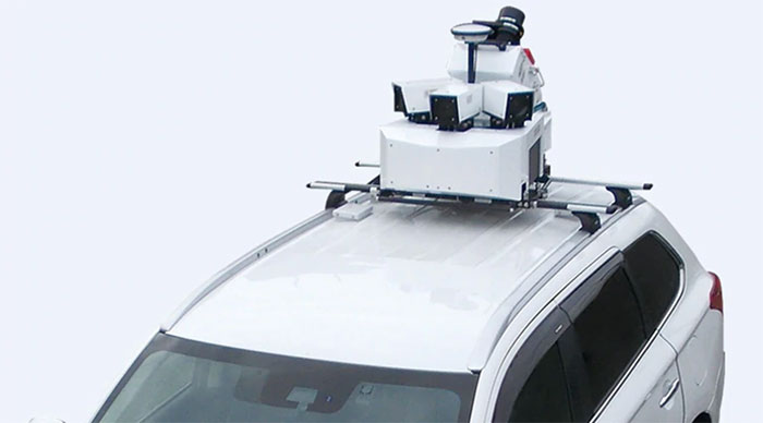
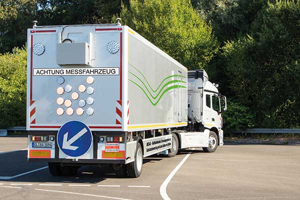
    Germany’s Federal Highway Research Institute (BASt) is using a specialized semi-truck to analyze and map road surfaces. The research vehicle uses GNSS, scanner and camera equipment to record the condition of road surfaces and the substance of the asphalt surface, providing the basis for optimum maintenance planning.

    The truck is part of the BASt’s MESAS program, which began in 2018. The unique measuring vehicle is a multi-functional assessment tool for fast-moving substance detection, such as for structural evaluation and design of pavements.

    For the MESAS program, innovative measurement technology was installed on a single-axle semi-trailer, with all measurement systems synchronized and georeferenced using a GNSS system.

    The MESAS measuring vehicle is 14.5 meters long and weighs 22 tons. At speeds of up to 80 km/h, MESAS records road condition parameters with high precision. (Photo: BASt)
    The MESAS measuring vehicle is 14.5 meters long and weighs 22 tons. At speeds of up to 80 km/h, MESAS records road condition parameters with high precision. (Photo: BASt)

    The vehicle includes:

    • the Pavement Profile Scanner PPS-Plus from Fraunhofer IPM
    • a laser-based Traffic Speed Deflectometer (TSD) that measures short-term reversible deformations of the road surface
    • a georadar that detects layer thicknesses and inhomogeneity of the road superstructure
    • ambient cameras that provide images for interpreting the georadar measurements

    During test runs, the vehicle system successfully measured more than 11,000 kilometers of the country’s trunk-road network. Now it begins regular operation.

    “MESAS is a globally innovative measuring system,” said Dirk Jansen, department head, BASt. “Here we have a really powerful tool at our disposal with which we can make an innovative and significant contribution to the further development of conservation planning.”

    Millimeter precision. The Pavement Profile Scanner PPS-Plus records the transverse evenness of the road surface with high precision. The scanner, the size of a shoe box, is mounted on measuring vehicles and scans the road surface with an eye-safe laser beam over a width of about 4 meters. The distance to the road surface is determined with sub-millimeter accuracy using phase-shift technology.

    The laser scans the surface with the aid of a rotating polygon mirror perpendicular to the forward movement of the vehicle and generates 800 profiles per second. Each profile consists of up to 900 measuring points, depending on the selected measuring frequency. In this way, the PPS generates a detailed 3D height profile of the road surface.

    At traveling speeds of 80 km/h, the measuring point distance in the longitudinal direction is approximately 28 millimeters; in the transverse direction it is 4.5 millimeters. It also provides photorealistic grey-scale images of the road surface that show millimeter-thin structures, such as small repairs and patches.


  • NovAtel debuts PwrPak7-E2 at Intergeo 2019

    NovAtel’s Neil Gerein discusses the company’s PwrPak7-E2, which was launched at Intergeo 2019 in Stuttgart, Germany.

  • Mitsubishi Electric launches High Precision Positioning Systems Division

    Mitsubishi Electric launches High Precision Positioning Systems Division

    According to Mitsubishi Electric, its Mobile Mapping System uses car-mounted GNSS antennas, laser scanners and cameras to gather 3D positioning data for road assets with high-level accuracy. (Photo: Mitsubishi Electric)
    According to Mitsubishi Electric, its Mobile Mapping System uses car-mounted GNSS antennas, laser scanners and cameras to gather 3D positioning data for road assets with high-level accuracy. (Photo: Mitsubishi Electric)

    Mitsubishi Electric Europe B.V. has established a High Precision Positioning Systems Division at its German branch headquarters in Ratingen, Germany.

    According to the company, the new division offers key technologies to German and European customers to accelerate the introduction of centimeter-level autonomous driving and safe driving assistance. These solutions include the Mobile Mapping System (MMS) and the high-precision AQLOC positioning receiver with centimeter-level accuracy for applications in road and utility vehicles, harbors and drones, as well as the agricultural sector.

    AQLOC will be compatible with GNSS services and positioning data augmentation services by Sapcorda, a joint-venture by Mitsubishi Electric, Bosch, Geo++ and u-blox. MMS uses car-mounted GNSS antennas, laser scanners and cameras to gather 3D positioning data for road assets with high-level accuracy, creating the comprehensive, high-definition 3D maps needed to support autonomous driving, the company said.

    The high-accuracy positioning receiver AQLOC will be compatible with GNSS services and positioning data augmentation services provided by joint venture Sapcorda. (Photo: Mitsubishi Electric)
    The high-accuracy positioning receiver AQLOC will be compatible with GNSS services and positioning data augmentation services provided by joint venture Sapcorda. (Photo: Mitsubishi Electric)

    “We are happy to add this new business area to our wide-ranging mobility solution portfolio, which already includes automotive equipment, power devices and railway systems,” said Andreas Wagner, president of the German Branch of Mitsubishi Electric Europe B.V. “The High Precision Positioning Systems Division rounds out our mobility sector and will offer German and European customers essential technologies for highly precise autonomous driving systems in a variety of scenarios.”

    Mitsubishi Electric Corporation is making mobile mapping and high-precision positioning systems available in Europe, North America, Asia and Oceania. The company also will showcase the new business unit’s portfolio at Intergeo 2019, which will take place Sept. 17-19 in Stuttgart, Germany.

  • Topcon showcases GTL-1000 scanner at Intergeo 2019

    Topcon Positioning Group displayed its GTL-1000 scanner at Intergeo 2019, which took place Sept. 17-19 in Stuttgart, Germany. According to the company, the GTL-1000 is a compact scanner integrated with a fully featured robotic total station, enabling a site engineer to complete a layout and scan on a single setup.

  • First of Batch 3 Galileo payloads delivered with evolved clocks

    First of Batch 3 Galileo payloads delivered with evolved clocks

    Galileo is on the march with a new generation of satellites bearing improved atomic clocks. The first of the Batch 3 navigation payloads was delivered in June by Surrey Satellite Technology (SSTL) in the UK to OHB System AG in Bremen, Germany.

    SSTL’s payload for Batch 3 is a recurrent build of the existing FOC payload, with an evolution of the atomic clocks to incorporate advances made under the European GNSS Evolution Programme. The earlier SSTL Galileo FOC payload comprised different units including European-sourced atomic clocks, navigation signal generators, high power traveling wave tube amplifiers and antennas.

    The new payload will be integrated aboard the satellite platform Galileo FOC FM23, named Patrick in honor of the winner of a drawing competition. Payload integration will be followed by a series of comprehensive test activities. Patrick and its next youngest sibling satellite of this series are scheduled to be ready for launch in autumn 2020.

    “We are looking forward to this first ‘marriage’ of a Batch-3-payload and platform and are ready to start Patrick’s test sequence soon,” said Lars Peters from OHB System AG, in charge of the Assembly Integration and Test for the satellites at eleven production islands where one satellite is completed every five weeks.

    “The ambitious schedule means that looking forward reserve satellites will be available both in orbit and on the ground,” added Dr. Wolfgang Paetsch, a member of the OHB System AG Management Board responsible for navigation, Earth observation and science.

    Paetsch received a PNT Leadership Award from GPS World magazine in 2017. At that time, Paul Verhoef of ESA, accepting on behalf of Paetsch, stated:

    “Of course we are waiting a bit to see what the real lifetime of the satellites is going to be. We don’t know that yet but we will find out in the next couple of years. Obviously there is a lot of pressure for further innovation, for further improvements. The user community over the last couple of years has become more outspoken about what they want and what they expect, which is nice. Obviously we need to take care of the legacy users, and we are having to see what new technology would allow us to do.”

    OHB System AG has contracted to deliver a further twelve satellites of this Batch 3 for Galileo. This will bring to 34 the number of Galileo satellites being supplied by the SSTL-OHB partnership. Of these, 14 are already in orbit.


    Feature photo: The satellite Patrick, first of Galileo’s Batch 3, will eventually travel from OHB to ESA’s ESTEC technical centre (shown here) in Noordwijk, the Netherlands for rigorous testing in simulated space conditions. (Photo: European Space Agency)

  • European Navigation Conference brings GNSS community together

    European Navigation Conference brings GNSS community together

    ENC logo
    ENC logo

    The 28th edition of the European Navigation Conference (ENC 2020) will be held May 11-14 at the International Congress Center in Dresden, Germany.

    The conference is hosted by the German Institute of Navigation (DGON). Because of the rapid development of analog and digital technologies, there is increasing progress in performance of GNSS.

    The conference brings together scientists, engineers and international experts to discuss new ideas, latest research results, future developments and new applications. High-level presentations will allow each participant to receive an in-depth view on the current status of satellite navigation technology. Topics include:

    • GNSS Updates & Policies
    • GNSS Algorithms & Techniques
    • Resilience and Autonomy
    • Multi-Sensor & Data Fusion
    • Aviation & Marine Navigation
    • Space & Science Applications
    • Mobility and Transportation

    Speakers. Keynote speakers will be Julia Klöckner, Federal Minister of Food and Agriculture, and Dr. Pascale Ehrenfreund, German Aerospace Center, chair of the Executive Board.

    Expo. A technical exhibition provides an opportunity for companies, agencies and research institutions to display their offerings; it will be directly placed in the conference area.

    Abstracts. The European Navigation Conference aims to provide a forum for both academic and industrial professionals in navigation topics from all over the world and to bring together academicians, researchers, engineers, system analysts, graduate and undergraduate students with government and non-government organizations to share and discuss both theoretical and practical knowledge. Experts are invited to submit outstanding and valuable original research papers and participate in the technical exhibition during the conference. The deadline for abstracts is Nov. 1, 2019.

    About Dresden. The city of Dresden is located at the river Elbe and has a long and colorful history. Although Dresden is a relatively recent city of Slavic origin, it is well-known as the capital and royal residence for the Electors and Kings of Saxony, who for centuries furnished the city with cultural and artistic splendor. After the reunification process in 1989, Dresden has regained importance as one of the cultural, educational, political and economic centers of Germany and Europe.

    Learn more at the conference website.

  • Javad GNSS showcases J-Mate at Intergeo 2018

    Javad GNSS’ Javad Ashjaee gives GPS World an overview of the company’s J-Mate at Intergeo 2018 in Frankfurt, Germany. According to Javad GNSS, the J-Mate is a total solution that features a camera that can automatically identify targets, a laser module for accurate distance measurements, and two motors for control of precision encoders that measure vertical and horizontal angles to the targets.

  • Caliper releases country package for Maptitude mapping software

    The 2018 DACH Country Package for Maptitude includes 4th quarter 2017 map content for Germany, Austria, Switzerland and Liechtenstein. (Photo: Caliper)
    The 2018 DACH Country Package for Maptitude includes 4th quarter 2017 map content for Germany, Austria, Switzerland and Liechtenstein. (Photo: Caliper)

    Caliper has lunched a 2018 DACH Country Package for its Maptitude mapping software. According to the company, Maptitude country packages bring the power and flexibility of its Maptitude product suite to a global audience and enable its customers to make geolocation-based decisions internationally.

    The 2018 DACH Country Package includes fourth quarter 2017 map content for Germany, Austria, Switzerland and Liechtenstein. The updated map includes refreshed streets and landmarks, as well as updated travel times and improved address matching.

    According to the company, users can seamlessly switch between the countries purchased, and doing so will refresh the Maptitude interface with country-specific tools, such as those for territory and sales mapping, finding, pin mapping, routing, displaying demographics and Create-a-Map Wizard.

    Caliper develops geographic information systems software, and its Maptitude software is designed to be a cost-effective, professional mapping software product. Maptitude also enables organizations to leverage their location-based data to improve decision making and planning, while minimizing expenditure through competitively priced solutions, the company added.

  • Munich SatNav Summit 2019 to focus on augmented reality

    Experts from all over the world will discuss positioning, navigation and timing (PNT) and their role for augmented/mixed reality at the Munich Satellite Navigation Summit 2019. The summit will take place March 25-27, 2019, at the Alte Kongresshalle in Munich, Germany.

    “Augment Yourself with GNSS…” is the theme of the 2019 summit. The organizing Institute of Space Technology and Space Applications (ISTA) of the Universitaet der Bundeswehr Muenchen will invite experts to talk about the latest GNSS and PNT news and their role for augmented/mixed reality as well as other up-to-date technologies.

    The conference starts on March 25 with the Exhibition Opening and Champagne Reception at 16:00 hours, followed by the Opening Plenary Panel at 16:45 hours. Afterwards, a reception provides opportunities for high-level networking with experts from industry, science and government.

    Trending topics of the 2019 summit:

    • First- and second-generation of the European satellite navigation system Galileo
    • Modernization of the U.S. Global Positioning System
    • Status and modernization of the Russian Global Satellite Navigation System GLONASS
    • Developments of new global and regional systems like the Chinese Beidou (BDS), the Japanese QZSS and the Indian IRNSS
    • Augmented/mixed reality and the use of Android raw measurements
    • Autonomous systems
    • Civil use of the Public Regulated Service
    • GNSS satellites and the Space Service Volume
    • Legal aspects on selected topics in the field of GNSS.

    Learn more on the summit website.

  • Hexagon’s new PIM7500 GNSS receiver chosen for autonomous buses

    The Hexagon PIM7500 GNSS receiver.

    Hexagon’s Positioning Intelligence division has released the PIM7500 GNSS receiver explicitly designed for autonomous automotive platform development and solutions.

    The single-sided receiver features a compact form factor that solders down directly for easy integration with electronic control modules and artificial intelligence (AI) development platforms, the company said.

    The new receiver features dual-frequency GNSS reception from all available constellations including GPS, GLONASS, Galileo, BeiDou, NavIC, QZSS and SBAS. It offers sub-meter and centimeter-level positioning using Hexagon Correction Services to deliver the high-accuracy positioning required for the autonomous industry.

    The PIM7500 is available in low to mid-volume quantities, making it a suitable GNSS receiver for mileage accumulation fleets.

    “Hexagon Positioning Intelligence has a strong commitment to the automotive market and will utilize its leadership in GNSS-based technology to provide high precision and safe positioning systems to the automotive market — now and in the future,” said Andreas Niemann, business development manager at Hexagon Positioning Intelligence.

    PIM7500 chosen for autonomous buses

    Autonomous commuter buses are being developed by Bertrandt, with the PIM7600 GNSS receiver. The test system will be installed on a bus in Regensburg, Germany. (Photo: Patrick Reinig)

    Bertrandt, a European company that specializes in automotive controls technology development, has selected the PIM7500 receiver as the precise positioning component on its innovation platform.

    Bertrandt’s innovation platform uses the PIM7500 receiver and inertial measurement unit (IMU) from Hexagon Positioning Intelligence, combined with lidar sensors, to perform image processing for object detection, collect precise route data and generate highly accurate maps.

    The innovation platform will be implemented on one of the public transportation electric busses in Regensburg, Germany.

    “We are pleased to have Hexagon Positioning Intelligence onboard our innovation platform for this project,” said Ulrich Haboeck, team leader of electronics and software development at Bertrandt. “Hexagon Positioning Intelligence is the perfect fit to provide the GNSS sensor components for the platform because their technology will ensure the success of the project.”

    Bertrandt announced the innovation platform on May 16. Hexagon Positioning Intelligence will be participating in Bertrandt’s TechDays Sept. 27-28 to demonstrate automotive and safety-critical GNSS and inertial solutions.

    “Bertrandt is an ideal technology partner for us, and we are excited to be invited to have the PIM7500 as a component on their innovation platform,” Niemann said.

  • German ag society approves NovAtel receiver in automatic steering test

    A new report describes the benefits growers can experience using NovAtel’s TerraStar-C and TerraStar-L precise point positioning (PPP) technology with a SMART6-L GNSS receiver for automatic steering.

    The report, “DLG Test Report 6802, NovAtel SMART6L receiver PPP Automatic Steering Test,” was issued by the German Agricultural Society or Deutsche Landwirtschafts-Gesellschaft (DLG).

    DLG promotes technical and scientific progress in the agriculture and food sectors. Set up to test equipment and machinery, the DLG Test Center Machinery and Farm Inputs provide impartial information for practitioners.

    DLG awards a DLG-APPROVED quality mark to farm machinery that passes a limited test programme within a DLG usability test. Using a Fendt 828 Vario tractor, combined with the Fendt “VarioGuide RTK” steering system and the NovAtel SMART6-L receiver, steering accuracy was tested using both TerraStar-C and TerraStar-L correction services.

    NovAtel’s TerraStar-C correction service provides a 5 cm or less (95%) position accuracy, and TerraStar-L provides a 50 cm or less (95%) position accuracy with a 15-cm pass-to-pass accuracy. The DLG test is designed to measure steering accuracy under various conditions as part of the criteria to receive the DLG-APPROVED quality mark.

    The DLG test reported that NovAtel’s TerraStar-C correction service achieved 2-3 cm system steering accuracy on an A-B run on an even track at 8 km/h, and a 3.4 cm accuracy at 15 km/h. The long-term accuracy was reported at 3-4 cm over a 24-hour period. Also, the pass-to-pass error was less than 3 cm over the duration of an hour.

    The DLG test reported NovAtel’s TerraStar-L correction service at 17-18 cm accuracy during an hour A-B run on an even track at 8 km/h, and 10-11 cm accuracy on a contour run at 5 km/h. The pass-to-pass error remained below 15 cm for the duration of the tests.

    NovAtel’s SMART6-L was awarded the DLG-APPROVED quality mark after successfully completing the PPP autosteering test.

  • German Defense chooses Rockwell Collins NavHub system for GNSS

    German Defense chooses Rockwell Collins NavHub system for GNSS

    (Photo: Rockwell Collins)

    The German Ministry of Defense selected Rockwell Collins’ NavHub navigation system to provide GNSS availability to a variety of its military vehicles.

    The NavHub system serves as a next-generation GNSS- and Military-code (M-code)-enabled solution for the German Armed Forces.

    Customizable for ground and maritime platforms, NavHub provides a variety of vehicle interfaces, meets the standards required by military vehicle operators, and allows users to receive data from multiple secure and open-service GNSS constellations to simultaneously confirm the navigational solution.

    Access to multi-constellation GNSS and GPS M-Code will provide a significantly enhanced navigational solution over the current GPS-only solution.

    Work under the contract will be performed in Rockwell Collins’ facilities in in Europe.

    About the NavHub GNSS navigation system

    NavHub (Image:: Rockwell Collins)

    Based on Rockwell Collins Selective Availability/Anti-Spoofing Module (SAASM) GPS receivers, NavHub is strategically designed to meetfast-moving and demanding combat environments.

    Through the use of dual-installed GNSS receivers, NavHub provides an assured navigational solution, interfaces and GNSS upgrade path to support modern operations platforms.

    Features include:

    • Dual receiver card slots, enabling multi-constellation reception
    • SAASM security (expansion to M-code), expansion to multi constellation GNSS
    • Extended platform interfaces, including Ethernet, USB and CAN
    • Extended performance in a jammed environment (i.e., 41 dB while tracking and 24 dB during initial acquisition)

    “NavHub meets the critical mission need for accurate navigation support for fast-moving platforms and challenging environments,” said Claude Alber, vice president and managing director, Europe, Middle East and Africa for Rockwell Collins. “Our military GNSS receivers will provide significantly enhanced navigational capabilities to military vehicles and will mitigate terrain, forest and urban degradation as it will raise the number of satellites used from 28 to well over 100.”