Tag: Germany

  • Building GNSS you can trust: Lessons from testing in Germany and Japan

    Building GNSS you can trust: Lessons from testing in Germany and Japan

    Crowded cities with stacked road systems and reflective architecture may offer impressive skylines, but for GNSS receivers, they create some of the harshest conditions on Earth. For technologies that depend on stable, trustworthy positioning, real-world testing in these challenging environments is essential. Here, Jez Ellis-Gray, product manager at Focal Point Positioning, a provider of GNSS positioning software, examines what recent field deployments reveal about the future of reliable GNSS.

    Urban environments present unique constraints that no laboratory or simulation can perfectly replicate. A lab test may miss the thousands of variables that influence signal behaviour in a living, breathing city or a dense forest road. This matters most for automotive applications, where positioning must remain stable and trustworthy to support driver assistance and higher levels of automation. That is why we conducted field trials across Germany and Japan, evaluating FocalPoint’s S-GNSS Auto software running on STMicroelectronics’ Teseo GNSS receivers in challenging real-world conditions.

    This testing demonstrated that GNSS performance in the real world is often determined not by peak accuracy under ideal conditions, but by the system’s reliability when satellite signals are distorted, reflected or partially obstructed.

    This distinction — between accuracy and reliability — is becoming increasingly important for sectors where positioning plays a safety-critical role, including automotive.

    Understanding the complexity of real environments

    Germany’s combination of modern architecture and medieval street layouts made it a good place to test GNSS upgrades against standard technology. A city like Frankfurt offers a nice mix of glass facades, narrow streets and tall buildings – conditions that tend to create multipath interference.

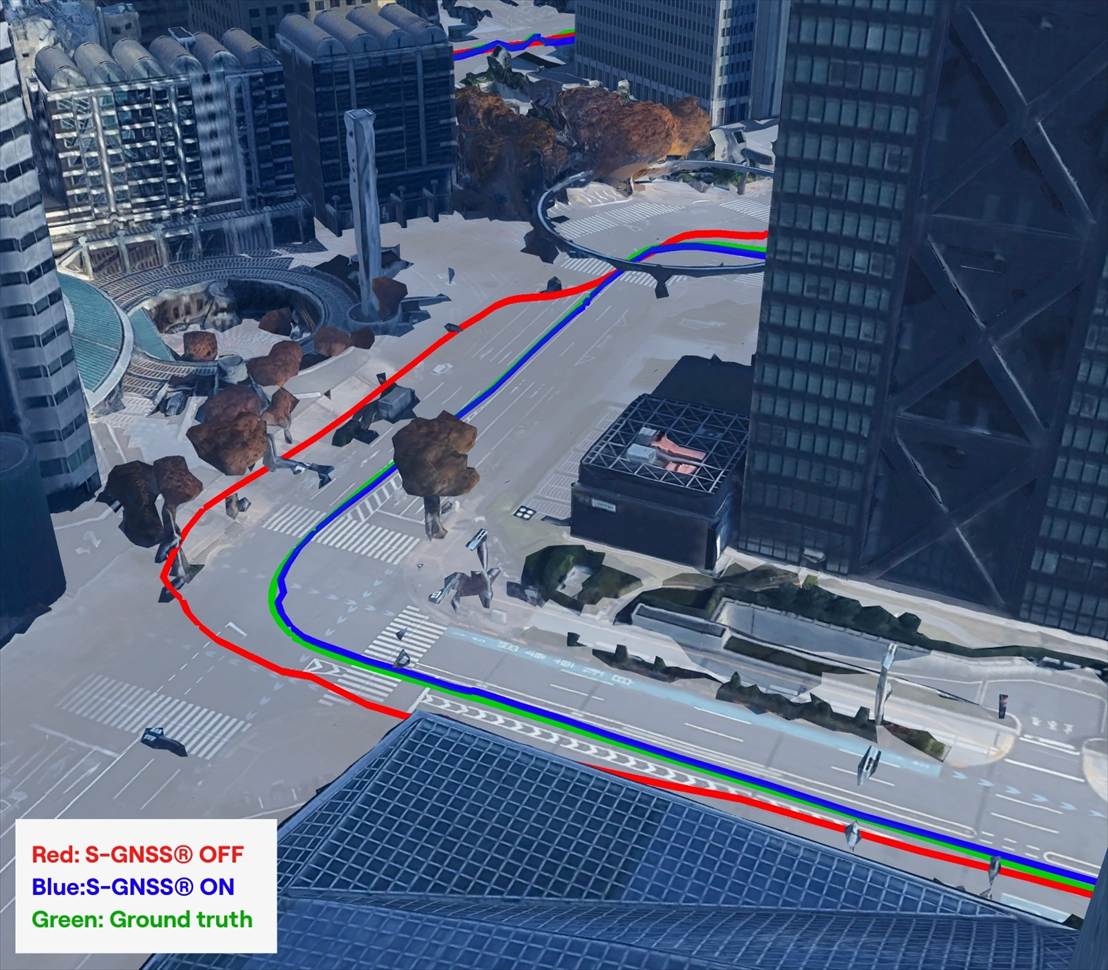
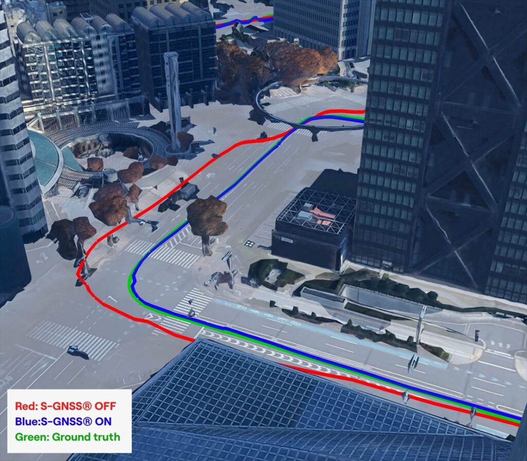
    During our recent field testing, conventional GNSS receivers frequently suffered from severe degradation of position accuracy when compared to a state-of-the-art ground truthing system. The standard receiver positions will often drift away from the travelled path, often through buildings or even onto parallel roads.

    As accuracy deteriorates, the receiver can usually tell that the input information is poor, and output a warning for a larger estimate of error.  This is a useful warning flag for AVs and allows for safe handover back to the human driver. However, in some cases, the reflected signals cause the miscalculation to be assumed correct. This “confident but wrong” GNSS is a much greater threat to autonomous driving, as the vehicle may make a dangerous decision based on this false information.

    In contrast, the S-GNSS Auto enhanced receiver was able to maintain lane-level accuracy far longer, even in areas where intense reflections would normally overwhelm the satellite data. In multipath-heavy environments, S-GNSS on Teseo receivers showed an accuracy improvement of up to 4x. These findings reinforced our belief that, as automation increases, consistency and reliability will be more valuable than peak accuracy.


    A navigation system that performs well on open motorways but struggles on urban roads will not scale safely to higher levels of vehicular automation. This is particularly relevant as the industry transitions from Level 2 to Level 3 autonomy, marking the point at which a vehicle takes full responsibility for the driving task in defined conditions, allowing the driver to disengage temporarily while the system manages safety-critical decisions.

    This shift is expected to unlock significant commercial value. A 2023 report by McKinsey predicted that advanced driver assistance and autonomous driving features could generate between $300 billion and $400 billion in annual revenue by 2035, driven by software services and subscription-based functionality that depend heavily on reliable positioning.  Unlocking this potential will depend on the next generation of vehicles having robust positioning systems, as users are unlikely to pay ongoing subscriptions to systems that repeatedly require human intervention or where safety concerns linger.

    Japan: one of the world’s most challenging environments

    If Germany represents a demanding test bed, Japan pushes GNSS to the extreme. Tokyo offers some of the toughest conditions anywhere in the world due to its towering buildings, multilevel road networks and narrow corridors that create intense multipath environments, so it was a natural choice for our next field test.

    The results showed that in particularly dense districts such as Shinjuku, standard GNSS receivers often struggled to maintain a coherent position solution. Reflections from glass towers, elevated highways and rail lines produced non-line-of-sight signals that overwhelmed conventional algorithms.

    S-GNSS Auto, integrated onto STMicroelectronics’ Teseo receivers, demonstrating improvements in vehicle positioning accuracy. (Data from Shinjuku, Tokyo)
    S-GNSS Auto, integrated onto STMicroelectronics’ Teseo receivers, demonstrating improvements in vehicle positioning accuracy. (Data from Shinjuku, Tokyo)

    However, receivers equipped with S-GNSS’s advanced signal-processing techniques demonstrated significantly improved performance. These upgraded devices maintained a stable positioning where traditional systems faltered, avoiding errors that would cause an automated system to disengage or provide dangerously erroneous positions

    This improved reliability has direct implications for safety and user experience, which vehicle OEMs will no doubt welcome. In driverless vehicles, GNSS problems that trigger sudden driver handovers or interruptions to hands-free modes, are likely to erode trust and reduce the likelihood of subscription renewals, as the end user will judge the product less by its peak performance and more by its dependability in everyday situations.

    Field testing and the future of positioning technology

    As cities evolve, buildings grow taller and mobility systems become more congested, the challenges facing GNSS will only increase. As such, automotive OEMs are rightly starting to demand real world results, not just in ideal conditions (static, open sky) but in the worst conditions.

    Manufacturers increasingly recognise that positioning is now a foundational technology that underpins safety, automation and customer experience. Investments in more reliable GNSS systems are therefore not marginal enhancements but essential enablers of future services. For companies developing navigation and sensing technology, real-world testing offers a unique opportunity to understand how systems react to chaotic, imperfect environments. It provides granular insight into where and why positioning fails, and how these software-based enhancements can bridge the gap. By validating these solutions in the world’s toughest GNSS environments, developers can offer manufacturers greater confidence in deploying advanced features across global markets.  


    You can request an evaluation kit here or download the full results report of our latest testing here.

  • Frankfurt welcomes INTERGEO 2025 as geospatial tech tackles global challenges

    Frankfurt welcomes INTERGEO 2025 as geospatial tech tackles global challenges

    Geoinformation has evolved from a specialist tool to an essential resource for government, business and civilian use. Whether captured from space or drones, analyzed through artificial intelligence (AI) or 3D visualizations, geographic data now, more than ever, drives critical decisions across industries.

    INTERGEO 2025 exemplifies this transformation. From Oct. 7-9, the Frankfurt Exhibition Center will host the world’s leading conference and trade show for geodesy, geoinformation and land management, featuring more than 500 international exhibitors ranging from innovative startups to industry giants.

    Three-Day Conference Program Features 100 Sessions
    The INTERGEO Conference will present approximately 100 presentations and sessions over three days, drawing speakers from space agencies, United Nations organizations, government ministries and international technology companies.

    Key topics include AI-powered remote sensing, urban digital twins, open data strategies, Earth observation for climate and crisis management and building information modeling (BIM) integration for infrastructure lifecycle management.

    Keynote presentations such as “Earth Observation and Artificial Intelligence” and “Cartography for the Future” will provide forward-looking insights, while panel discussions on digital sovereignty and standardization will address strategic frameworks. Each session demonstrates how geoinformation serves as the critical foundation for climate adaptation, disaster preparedness, urban development and infrastructure protection.

    Opening Day Features Space Technology Focus

    DVW President Prof. Rudolf Staiger will open INTERGEO on Tuesday, Oct. 7, followed by a keynote from Johann Dietrich Wörner, space coordinator for the state of Hesse. His presentation, “Earth Observation and Artificial Intelligence,” will explore how AI transforms massive Earth observation datasets into actionable insights for climate, agriculture and urban planning projects.

    Prof. Serena Coetzee of UNU-FLORES will deliver the German Cartography Congress keynote on Wednesday, Oct. 8, addressing cartography’s evolution amid growing geodata volumes and governance challenges.

    Thursday morning’s panel discussion, “Digital Transformation – Perspectives, Trends and Theses,” will examine the need for reorienting geoinformation management to foster innovation and collaboration.

    Revolutionizing Geospatial Data Analysis

    AI is accelerating the transformation of raw data into actionable insights, fundamentally changing how professionals work with geoinformation. The session “AI-Based Analysis of Remote Sensing Data for Updating the ATKIS Basic DLM” demonstrates practical applications in public administration.

    The Hessian Administration for Soil Management and Geoinformation uses AI methods to automatically detect landscape changes, significantly improving the quality and timeliness of digital landscape models.

    Urban digital twins are rapidly advancing from static models to powerful operational platforms. The session “From Data to Insights: Visualization Technologies for Next-Generation Digital Twins” will showcase how modern visualization makes complex systems accessible and accelerates planning processes.

    The research project “DigitalCities4Us” illustrates practical applications, using high-resolution 3D data to enable barrier-free urban planning and improve accessibility for people with mobility restrictions.

    Additional sessions will examine implementation across administrative levels. “The Digital Twin NRW: A Practical Report” presents a statewide geospatial data infrastructure that is freely accessible and continuously developed. The city of Zurich will demonstrate its transition from traditional geospatial data infrastructures to multifunctional twin platforms.

    Geodata infrastructures, open data and data spaces form the backbone of digital transformation and serve as key prerequisites for digital sovereignty. Multiple sessions will emphasize the importance of stable, future-ready geodata infrastructure.

    Standardization receives particular attention through presentations like “Three Perspectives, One Goal: Digital Sovereignty through Open Standards in BIM and GIS” and the position paper “Official Geodata as a Basis for Digital Processes in Planning, Construction and Operation.” These sessions demonstrate how uniform standards for data exchange between geographic information systems and building information modeling can accelerate planning, construction and operational processes.

    The position paper represents a joint initiative of buildingSMART Germany, the Working Committee of the Surveying Authorities and the Federal Association of Publicly Appointed Surveyors.

    Critical infrastructures require precise, reliable data to minimize risks. The presentation “Regional and Effective Flood Protection in the State Capital of Düsseldorf” demonstrates how geoportals and flood forecasting tools prevent flooding and strengthen urban infrastructure resilience.

    Bringing Innovation to the Exhibition Floor

    Registration is now open at the INTERGEO website. The INTERGEO 2025 team looks forward to welcoming attendees to the Frankfurt Exhibition Center from Oct. 7-9.

  • Secure your spot at INTERGEO 2024

    Secure your spot at INTERGEO 2024

    Photo: INTERGEOINTERGEO 2024, the premier global event for geodesy, geoinformation and land management, will take place from Sept. 24 to 26, 2024, in Messe Stuttgart, Germany. This year’s theme focuses on the power of geoinformation technologies and their critical role in addressing global challenges.

    The event is expected to bring together more than 600 international brands, industry leaders and business professionals, providing a unique platform for networking, collaboration and knowledge exchange among geospatial professionals.

    The event will cover a variety of topics, including building information modeling (BIM), Earth observation, digital twins, maritime solutions and developments in the UAV industry. A significant emphasis will be placed on how geoinformation technologies can help tackle pressing issues such as climate change, urbanization and resource management. Earth observation will be a focal point, featuring sessions dedicated to managing the green transition and discussing strategies for climate adaptation. This comprehensive event aims to showcase the potential of advanced geospatial technologies in contributing to solutions across the globe.The conference will feature keynote speeches from industry leaders and government officials, including Walther Pelzer Ph.D., Head of the German Aerospace Center, who will deliver a keynote on “Earth observation for a world in transition”. Burkhard Boeckem, Ph.D., CTO of Hexagon AB, will discuss developments at the forefront of geospatial technology.

    Catch GPS World at INTERGEO 2024 from Sept. 24 to 26!

    Click here to register and learn more about the conference.

  • Lidar reveals lost cities in the Amazon

    Lidar reveals lost cities in the Amazon

    A lidar map of the city of Kunguints in the Ecuadorian Amazon reveals ancient streets lined with houses. (Image: Antoine Dorison and Stephen Rostain)
    A lidar map of the city of Kunguints in the Ecuadorian Amazon reveals ancient streets lined with houses. (Image: Antoine Dorison and Stephen Rostain)

    Archeologists have discovered a vast and highly complex system of ancient cities dating back nearly 3,000 years in the Amazon rainforest. Complete with a complex network of farmland and roads, the discovery is the oldest and largest of its kind in the region.

    Located in Ecuador’s Upano Valley, the structures lie in the eastern foothills of the Andes mountains, according to a study published in the journal Science. After more than 20 years of research, the ancient urban centers were only discovered when the Ecuadorean government employed lidar technology.

    “I have explored the site many times, but lidar gave me another view of the land,” archaeologist Stéphen Rostain, lead author of the study and director of research at the French National Center for Scientific Research (CNRS), told Live Science. “On foot, you have trees in the way, and it’s difficult to see what’s actually hidden there.”

    A team of researchers from France, Germany, Ecuador and Puerto Rico conducted a lidar survey that covered roughly 300 km2. The survey revealed a landscape full of organized human activities, including more than 6,000 rectangular earthen platforms, as well as agricultural terraces and drainage systems.

    According to the study, these structures formed at least 15 distinct settlements, which were connected by a system of wide, straight roads. Co-author Antoine Dorison, an archaeologist at the CNRS, said that this society’s complexity is especially evident in this web of streets, which were carefully constructed to cross at right angles rather than follow the landscape.

    In recent years, lidar has been a vital tool for discovering traces of ancient civilizations. Lidar allows researchers to survey densely forested areas that are difficult to explore on foot and allows for the creation of accurate maps in a fraction of the time.

    In August 2023, a team of researchers in a biological preserve in Mexico’s Campeche State used airborne lasers to cut through dense vegetation. This revealed ancient structures and human-modified landscapes beneath, including pyramids, palaces, and a ball court. The team was able to explore the dense area safely and identified the ancient Mayan city they discovered as Ocomtún.

  • INTERGEO 2023: Recap

    INTERGEO 2023: Recap

    On the first day of INTERGEO 2023, attendees flooded the exhibit hall.
    On the first day of INTERGEO 2023, attendees flooded the exhibit hall. (All photos taken by GPS World staff).

    The 29th INTERGEO conference and trade show on geospatial technology and data was held from October 10 to 12 in the German capital Berlin. This year’s event took place under the famous radio tower and in the brand new Hub27 conference center, part of the 42-acre Messe Berlin exhibit and conference center. The annual event takes place each year in a different German city.

    Over the three days, 560 vendors from more than 40 nations exhibited their products, while people from across the globe attended presentations and vendor exhibits on geodesy, geoinformation and land management. Topics covered included Earth observation and environmental monitoring, maritime solutions, unmanned systems, building information modeling (BIM), GIS and artificial intelligence, metaverse and cloud applications, smart cities, digital twins, COPERNICUS and Galileo satellite services, 4D geodata, 3D cadaster, and smart mapping applications. The focus was on how these technologies and data are used to address issues of housing, mobility, sustainability, climate change and internal security, monitoring for disaster prevention and protection, and the creation of more equitable living conditions.

    In conjunction with the conference, the German Cartography Congress 2023 also convened, with lectures on such topics as atlases, map collections, map design, and artificial intelligence. In her keynote address, Professor Monika Sester discussed how machine learning methods help with generalization and Professor Sebastian Meier gave a provocative lecture titled “Critical Cartography in Times of Hallucinating Machines.”

    Attendees at a presentation from the exhibit hall stage.
    Attendees at a presentation from the exhibit hall stage.

    Day 1, Tuesday, October 10

    On the first day of INTERGEO 2023, keynote speakers included Jack Dangermond, founder and CEO of ESRI, professor Paul Becker, president of the Federal Agency for Cartography and Geodesy, Scott Crozier from Trimble and professor Rudolf Staiger, president of the organiser DVW e.V. The main theme was the centrality of geospatial science and technology to sustainability because the basis of socially, ecologically and economically sustainable decisions lies in the understanding of the Earth system. This is increasingly achieve using geoinformation gathered through Earth observation and many other sensors.

    GPS World conducted short interviews with Gustavo Lopez, market access manager at Septentrio and Deyn Deng, overseas sales manager at Unicore.

    Some surveying supplies that have been used for centuries are still in use today.
    Some surveying supplies that have been used for centuries are still in use today.

    Day 2, Wednesday, October 11

    On the second day of INTERGEO 2023, the focus of the keynote presentations, like that of many of the products in the exhibit hall, was “smart cities” and building information modeling (BIM), including a panel discussion on the importance of BIM in Germany. Related themes discussed in the presentations, on the exhibit hall stages, and at vendors’ booths included connected urban twins, sensor data, real-time applications, urban twins as drivers of innovation for local governments, maritime solutions, Earth observation, and unmanned systems.

    An autonomous bathymetric vessel from Teledyne Marine.
    An autonomous bathymetric vessel from Teledyne Marine.

    At a press conference on navigating sustainability through geospatial insights the participants were Rudolf Staiger, president of DVW, Boris Skopljak, Vice President survey & mapping strategy and product marketing at Trimble, Thomas Harring, president Geosystems at HexagonGerd Buziek, Business Relations Executive at Esri Deutschland and Godela Roßner, head of Earth observation at Deutsches Zentrum für Luft- und Raumfahrt (DLR).

    This UAV from CHCNav can take off and land like a helicopter and fly like a plane.
    This UAV from CHCNAV can take off and land like a helicopter and fly like a plane.

    GPS World conducted short interviews with Andrew Scott, Head of Marketing & Sales at JAVAD GNSS; Jamie Birch, product manager at OxTS; Mandy Clayton, Southeast Regional sales mganager at GeoMax (part of Hexagon); Florian Ollier, head of marketing & communications at SBG Systems; Andrei Gorb, division product manager, Mapping Solutions at CHCNAV; Rachel Wong, Survey & Engineering Product Line, product manager at CHCNAV; Marcel Visser, CEO of NavCert; Ken MacLeod, product line manager and Bruce Shields systems group director at Tallysman; and Morgane Selve, head of marketing at Yellowscan.

    CHCNav’s Apache 4 autonomous bathymetric vessel.
    CHCNAV’s Apache 4 autonomous bathymetric vessel.

    Visser told GPS World that his company had obtained from the German federal government sole responsibility to certify UAVs in Germany for commercial operations, including flights beyond visual line of sight (BVLOS).

    Trimble’s GEDO CE 2.0 track measurement trolley.
    Trimble’s GEDO CE 2.0 track measurement trolley.

  • INTERGEO 2023 is fast approaching

    INTERGEO 2023 is fast approaching

    INTERGEO 2023 will take place Oct. 10-12, in Berlin, Germany, and GPS World staff will be in attendance. The main topics of the annual conference include Earth observation, maritime solutions, unmanned systems and building information modeling (BIM).

    The three-day event will also cover the topics of GIS and artificial intelligence, metaverse and cloud applications, Earth observation and environmental monitoring, smart city, infrastructure BIM, digital twins, satellite services COPERNICUS and Galileo, 4D geodata, 3D cadastre, smart mapping applications, Geobasis 2030 and 3D point clouds illuminated.

    In addition to international keynote speakers, the conference will focus on expert exchange and live experiences with panel discussions and networking events.

    While GPS World will not have a booth, attendees can catch Matteo Luccio, the magazine’s editor-in-chief, on the show floor.

    The INTERGEO conference program can be found here.

  • Allies send new UAVs to Ukraine

    Allies send new UAVs to Ukraine

    Image: sandsun/iStock / Getty Images Plus/Getty Images
    Image: sandsun/iStock / Getty Images Plus/Getty Images

    Ukraine’s allies in Europe are sending the country new UAVs and counter-UAV equipment, reported The Defense Post.

    German weapons provider Rheinmetall is preparing to send its LUNA NG (next generation) unmanned reconnaissance UAV to Kyiv, the company announced August 14. The system should be delivered by the end of the year, according to Rheinmetall.

    The LUNA NG is part of a sizable military aid package for Ukraine initiated by the German government in July. Per Rheinmetall, the package includes a ground control station and several UAVs, as well as a launch catapult, an optional net equipment for catching landing UAVs and equipment for rapid repair. The system is mounted on a Rheinmetall HX truck with a swap body system.

    The UAV is designed for a range of mission-specific payloads — including LTE network and electronic warfare support measures such as detection, classification and analysis of electromagnetic radiation for threat detection.

    UAV can remain aloft for more than 12 hours and maintain a datalink range of up to 100 kilometers normally, and up to 300 kilometers when fitted with optional satellite communication equipment, according to Rheinmetall.

    The Bundeswehr (the German military) has operated LUNA UAV systems since the early 2000s. Those were originally developed by German manufacturer EMT Penzberg, which was acquired by Rheinmetall in 2021.

    Berlin has already delivered several reconnaissance UAVs to Ukraine, including 88 Vector UAVs from Quantum Systems, 20 RQ-35 Heidrun systems Sky-Watch, and 32 unspecified reconnaissance UAVs, as of August 9.

    Ukraine will also soon receive a series of Cortex Typhon counter-UAV systems made by Norway’s Kongsberg, after the company signed an agreement via the International Fund for Ukraine.

    The delivery consists of several Cortex Typhon systems — developed to counter a wide spectrum of UAVs with solutions to either physically harm or disable an aerial threat, Kongsberg said.


  • RIEGL laser scanner meets German UAV

    RIEGL laser scanner meets German UAV

    Image: RIEGL
    Image: RIEGL

    REIGL and StriekAir engineering GmbH have successfully completed the integration of an airborne scanning system, the RIEGL VUX-12023, on the StriekAir VTOL CarryAir UAV from Germany. During its inaugural flight, the integrated technology successfully captured accurate data of the ground structure.

    The RIEGL VUX-12023 laser scanner is recognized for its precision and accuracy in aerial surveys. When integrated with the VTOL CarryAir, the UAV can reach a cruising speed of 85 km/h and offers users a combination of point cloud density and efficient data acquisition.

    With the integration, users can acquire data about eight times faster than with conventional multicopters, according to REIGL. This time-saving feature aims to provide users with enhanced efficiency and data accuracy.

    Matthias Hutecek (RIEGL) and Thomas Strieker (StriekAir engineering GmbH). (Image: REIGL)
    Matthias Hutecek (RIEGL) and Thomas Strieker (StriekAir engineering GmbH). (Image: REIGL)

    The UAV can be utilized in a variety of applications — including surveying construction sites and infrastructure projects, mapping corridors, collecting topographic data for urban planning and environmental studies and more.

    The RIEGL VUX-12023 offers smooth integration on UAS/UAV/RPAS, small manned airplanes and helicopters. It is offered as a stand-alone UAV lidar sensor and also in various fully integrated UAV-based laser scanning system with appropriate INS/GNSS system and optional cameras based on users’ needs.

  • Galileo gains new ground segment facility

    Galileo gains new ground segment facility

    Image: ESA
    Image: ESA

    Galileo’s ground segment has gained a new asset, the Telemetry, Tracking and Control (TT&C) facility — a 13.5-m parabola dish mounted on top of a 10-m high building structure of made of steel and concrete. It is based within Europe’s launch site in Kourou, French Guiana, beside TTCF-2.

    The TT&C antennas are uncrewed and operate on a fully automated basis from the two Galileo control centers located in Oberpfaffenhofen, Germany, and Fucino, Italy. The TT&C antennas are crucial to regular communication with the Galileo satellites.

    This latest antenna will play an important role during the upcoming modernization activities of the earlier TT&C antennas in the station network, which have been in service for several years. TTCF-7 will take over their tasks during the maintenance activities when they need to be taken offline.

  • Thales collaborates with EuroHAPS on demo project

    Thales collaborates with EuroHAPS on demo project


    Image: Thales Alenia Space
    Image: Thales Alenia Space

    Thales Alenia Space has signed a €43 million contract for the Euro High-Altitude Platform Systems (HAPS) demonstration project. EuroHAPS was selected by the European Commission on July 20, 2022, for collaborative defense research and development projects from the European Defense Fund.
    EuroHAPS aims to develop several stratospheric demonstrators for missions designed to improve intelligence, surveillance and reconnaissance and communications capabilities. Project partners include companies from Italy, Spain, Germany and France.

    The project will conduct flight demonstrations for three types of complementary stratospheric platforms: A reduced-scale Stratobus from Thales Alenia Space, a solar-powered airship designed for long-endurance missions and offering large payload capacity, Hybrid High Altitude Airship from the Italian Aerospace Research Centre capable of generating extra lift with a wing airfoil, and autonomous stratospheric balloon system from ESG and TAO consisting of a series of three altitude-controllable balloons.

    These three types of platforms are complementary and feature different operating times, capacity and operational restrictions. They will give Europe a broad spectrum of solutions to meet a variety of different requirements.

    The platforms will test a range of missions, including lidar observation to detect and classify targets at sea or on land and the ability to detect them in environments with vegetation cover. Communications intelligence and electronic intelligence missions will also be tested, as well as a meshed broadband communications network for air and land players.

    HAPS offer a new opportunity to complement ground-based, satellite-based or airborne assets with unique capabilities tailored to operational requirements. These flight demonstrations of HAPS will enable demonstrations of different platforms and address the main technical risks associated with these new technologies while refining operational requirements to ultimately enable development of future HAPS systems.

  • ICA Summit 2023 registration now open

    ICA Summit 2023 registration now open

    The third Innovative, Connectivity, Autonomous (ICA) Summit will take place May 15-16, 2023, in Frankfurt, Germany.

    The ICA Summit 2023 will focus on the various levels of automated vehicles and how the industry is being redefined by fast-changing technology. Industry professionals will discuss how manufacturers and suppliers will integrate key connectivity requirements to achieve advanced levels of autonomous driving.

    The closed-door ICA Summit will dive into innovative solutions and regulatory framework of development and validation. Attendees will have a chance to explore the latest developments in the industry and share their insights on the following topics:

    • “Autonomous vehicles: Future is today”
    • “Connectivity should not be an option for today’s vehicle”
    • “ADAS: From ABS to level 5”
    • “Software and hardware: The key to superior AI”

    For more information and to register, visit the ICA Summit 2023 website.

  • Live INTERGEO exceeds expectations

    Live INTERGEO exceeds expectations

    INTERGEO, a huge geospatial conference, was hosted in Essen, Germany and digitally on October 18-20. The event was attended by 457 exhibitors from 31 countries and about 14,000 trade visitors from 102 countries. “The results clearly exceed our expectations. We are very pleased to finally be able to bring many people together again with the live event,” explained Prof. Dr. Hansjörg Kutterer, President of the organizer, DVW e.V., Association for Geodesy, Geoinformation and Land Management.

    This year, INTERGEO placed a focus on digital twins. Cooperation, collaboration and the sharing of information are crucial for the success of the digitalization of city, country and space. Other focal points of this year’s INTERGEO included smart cities, building information modelling (BIM), sustainability, mobility, and climate change.

    The EXPO, the event’s exhibit area, presented a broad portfolio of the geospatial industry. In addition to terrestrial recording and airborne solutions such as drones, exhibitors also presented automated solutions for recording space. Geoinformation systems and BIM solutions demonstrated their potential in data analysis, monitoring and decision support.

    The DVW is also working to raise awareness for the geospatial sector and to demonstrate its potential. For the first time, Prof. Kutterer awarded the newly created “DVW Future Prize” to the “Connected Urban Twins” project with the participating cities of Hamburg, Leipzig and Munich. The DVW Future Prize is awarded for groundbreaking ideas of outstanding interdisciplinary and social significance.

    To promote young talent, the DVW presented the “INTERGEO Next Generation Science and Geoinnovation Award,” honoring outstanding pitches on young researchers’ work. This year’s winner, Steffen Becker from the Karlsruhe Institute of Technology, was awarded for his master’s thesis on traffic monitoring with drones.

    Next year, INTERGEO will take place in Berlin, October 10-12.