Remote GeoSystems Inc., a global provider of geospatial video recorder hardware and GIS integration software and solutions, has become an official Silver Partner in the Esri Partner Network after successfully building its business as an Emerging Business Partner in the Esri Startup Program.
Esri offers a Startup Program enabling the most promising emerging businesses to incorporate these innovations into their services and solutions.
Now in its third year, the Esri Startup Program provides the ArcGIS software, online services, support, community involvement and training to kick-start product development or enrich existing solutions.
Remote GeoSystems was one of the first early-stage startups accepted into the program.
“As a small technology company bootstrapping the development and innovative product sales efforts, access to Esri’s flagship ArcGIS platform and team support was invaluable,” said Jeff Dahlke, managing director of Remote GeoSystems.
The LineVision Desktop. (Image: Remote Geosystems)
In its three years in the program, Remote GeoSystems was able to successfully develop and go to market with an array of geospatial video solutions. The company’s LineVision Esri ArcMap Add-in and stand-alone LineVision Desktop with Esri Mapping commercial software tools provide georeferenced video playback, analysis, collaboration and reporting using the Esri ArcGIS platform.
In addition, the new Video GeoTagger and Video GeoEditor (coming soon) products, also built with Esri mapping technology, will be available for use on the ArcGIS Marketplace.
These professional geospatial video and integrated GIS Full Motion Video (FMV) software tools are suitable for airborne, drone and mobile mapping surveys, critical infrastructure inspection and public safety applications.
“The Remote Geo team is building some very feature-rich and capable Esri-based solutions and Add-ins while also bringing a valuable mix of GIS, GPS, deep location-based video expertise and multi-industry experience,” said Francis Kelly, Esri Global Partner Programs manager. “We are excited to work with Remote Geo as their business matures and they continue to contribute to the Esri user community as part of the Esri Partner Network.”
“As a company that was once a startup, we understand the early years for any business are hard,” said Katie Decker, Esri Startup Team community manager. “We are impressed with how the Remote Geo team executed on the opportunities provided by the program, bringing the value of geospatial video to a broader audience using the Esri platform. Their experience is what we envisioned when we implemented the program and we look forward to continuing to work with them.”
Remote GeoSystems LineVision Esri-based solutions key features often include:
Play videos from single and multi-camera video data collection platforms
“Click-on-Map” video navigation
Set a custom geo-fence around the moving position marker
Load shapefiles, imagery and ArcGIS Online datasets
Save geotagged video and photo data as geoProjects for simple project reporting, archive and search
Support for DJI Drone Video data.
All Remote GeoSystems Esri-based solutions are and/or will soon be available in the ArcGIS Marketplace.
The startup PlanetWatchers has developed Foresights, a risk management and geospatial analytics platform designed specifically to help clients manage forestry assets quickly, effectively and accurately.
Foresights identifies areas of new or potential risk, and delivers operations tracking and forest damage management services. The company plans to add satellite-driven analytics, inventory data and forest productivity services to the platform. before the end of the year.
The Foresights platform covers larger geographic areas and delivers results faster and more accurately than traditional project-based companies, traditional inventory methods and off-the-shelf processing tools, the company said.
PlanetWatchers combines multi-source satellite imagery data, topography maps, soil maps, meteorological data and near real-time ground input from operational teams to deliver optimized insights. The tool is capable of detecting disturbances as small as 0.1 ha (0.25 ac) related to pest, disease and drought damage.
Foresights will help forest managers “easily access crucial business intelligence and detailed insights and analytics on a regular basis so they can make proactive and informed decisions and take immediate remedial action,” said Ariel Smoliar, PlanetWatchers’ CEO and co-founder. “Without these higher levels of data and improved frequency of information, they could see negative impacts on their forestry management decisions, their supply chains and, ultimately, their profits.”
Reports identifying locations that require immediate mitigation can be viewed in existing GIS systems and are geolocated for forestry field teams, including offline capabilities for teams operating in remote areas without cellular reception.
“Foresights also fills a data gap known as the ‘Last Mile of Analytics’,” Smoliar said. “When we deliver satellite images to our clients, they shouldn’t have to then analyze and extract information. We remove this pain point for them by providing deep analysis of optical and radar satellite images, and compiling actionable insights and reports, including detailed maps of locations of interest. Our clients are shown not only the location of the disturbance, but also the issue and its cause, granting them vital intelligence they can act on with very little lag time. Foresters will no longer need to process or analyze imagery: this is the game-changing value of the Last Mile of Analytics.”
The Forest Operations service provides foresters with insights to track progress of various forest harvest operations such as thinning and clearcutting. This information assists operations managers in optimizing their wood supply chain and efficiently and effectively managing resources.
The Forest Disturbance service delivers location-specific reports to forest owners and managers detailing areas with identifiable disturbances that could degrade the quality, yield, and profitability of forests. Some disturbances that Foresights can identify to help commercial foresters respond proactively include growth and uniformity issues over time, illegal logging, insect infestations and disease, competitive vegetation, storm damage, drought, wildfires and more.
Who better to know about connections than a GIS professional whose very job is discovering them? Weaving a thread through time from decades ago isn’t a typical geospatial connection, but this one is, and it is connected by a person.
Let’s reflect on who we are as a profession and how we, the geospatial community, has made the world a better place.
Let’s also take a moment to learn about one of the leaders who led the way and what he had to overcome to help us appreciate who and what we are. It is an oft-repeated refrain: “Those who do not know the past are condemned to repeat it”, and, my personal favorite, “The future flows through us becoming the past so that we remember it and do not repeat it.”
Jack Maple. (Photo: Newsday Photo, 1986 / Bruce Gilbert)
In 1961, the trend in crime began climbing. Many people lived in fear, especially in big cities. New York captured many of the nation’s headlines in a long, tragic list of brutal, horrible crimes. Hope was bleak. It was expected to get worse. But, it didn’t. The fever had broken. It peaked in 1991. The crime spree lasted 30 years.
By contrast, the Vietnam War lasted 20 years. The total number of troops serving on active duty during Vietnam was 9.1 million troops and 58,318 lost their lives in combat, yet fewer people died on the streets of America during the same period. In fact, on average, during the 30-year crime wave, every 22 days the number of victims of violent crime in the United States equaled the total number of soldiers killed in Vietnam. America was a battlefield and ground zero was New York City.
What happened in 1991? What stemmed the tide? That year, a new type of hero emerged, a crime fighter, unlike any before.
It began at ground zero, in the most dangerous areas of New York City — the subways, referred to as the “caves.” Thugs, rapists, murders and thieves roamed the depths. Police could do little. They were outnumbered and operated under strict rules. It was preferable to be a regular police officer, above ground, dealing with routine crimes, even the murders, rather than be a transit cop covering a beat in the dark, rough, unforgiving underworld of the subway. Only four types of people dwelled there: criminals, victims, transit cops, and those who got away.
Sometimes, transit cops or criminals were the victims. Transit cops were difficult to recruit, but New York needed more of them. This provided an opportunity for those with few other choices. Sometimes, those who have no other options are the ones who make the most of an opportunity. They work the hardest because it is their only way out. Success lies with the willing — those incendiary hearts waiting to be ignited by a challenge that gives them purpose. Life is too often fraught with peril and strife. It is vision and the courage to pursue them that manifests dreams into reality.
This new hero didn’t fit the caricature. He was short, balding, overweight and lacked a high school diploma. He was street smart, cocky, unpolished and would rather fight than prove his point. He didn’t come from a privileged background. He just had his wits. He knew right from wrong and had the courage to stand his ground. He took on the criminal element lurking in the subterranean worlds. He worked hard, earning his GED at night. It served him better that way like a badge of honor, the hard way being its own reward.
His name was Jack Maple, the crime fighter, and he understood the streets in ways others didn’t. He knew, like a hunter knows, to find the deer trails. Animals are creatures of habit. They prefer to stay where they know the area, the smells, the rhythms, the sounds, where the food is, and where to run for cover. Criminals measure their risks too. They prefer familiar places. They are territorial and keen to their surroundings. Jack knew if you look for their patterns, you’ll find them. He covered his walls with subway maps, placing pins where and when the crimes happened.
The criminal’s habits and behaviors began taking shape. With this knowledge, Jack had become the hunter. Knowledge is power, but real power is action, and Jack took it. He would not have become the hero otherwise. He staked out their patterns of place and time, setting traps and luring them in with their weaknesses.
One by one, and group by group, he reclaimed New York’s subways. Crime dropped by 69% over the next five years. Putting that in perspective, two of every three victims were spared. Unfortunately, 629 people were still murdered in New York City, but it was a drastic departure from the peak of 1,946 just five years before, meaning 1,317 men, women and children did not suffer a violent crime that year or any other year thereafter.
The values of crime are most often represented as a 1:100,000 scale ration; however, this chart shows three different categories, each represented by a different order of magnitude. (Data from Disastercenter.com)
Rudy Giuliani, then mayor of New York, recognized the value of what Maple had developed. Maple called his maps the Charts of the Future. His colleagues called it wallpaper. The mayor called it amazing and gave Jack Maple his full support, praising him by saying, “One of the truly great innovators in law enforcement, who helped make New York City the safest large city in America.” Maple was promoted to Deputy Police Commissioner of Crime Control Strategies.
Maple founded CompStat, Computerized Statistics, calling it his electronic pin maps to support his four precepts: accurate and timely intelligence, rapid deployment of forces, effective tactics, and relentless follow-through.
New York’s CompStat program for the NYPD.
CompStat changed policing to a data-driven business. GIS professionals will recognize CompStat as a geographic information system, and Jack as a self-trained geospatial developer and analyst. Geospatial science was still a very niche technology at the time.
Jack Maple’s success continued to grow. Two men, William Bratton and John Timoney, both police commissioners and senior to Maple in the police hierarchy, became evangelists of Maple’s CompStat, spreading it to other cities throughout the world, and through those two men, predictive policing and crime mapping evolved.
Maple, Bratton and Timoney became independent consultants helping cities worldwide establish their own CompStat programs.
His success did not end there. Based on his experiences fighting criminals on the streets and fighting change in the antiquated police system, he wrote the book, The Crime Fighter: How You Can Make Your Community Crime Free. The book is an excellent read and readily available online. He also co-wrote the TV series The District, based on his exploits in the book.
If you haven’t seen the series, the show is worth watching. Season 1, Episode 3, shows a 1990s projector screen with a large GIS display and the city’s police chiefs being held to account for telling their district’s crime stories in accordance with the map.
Jack Maple was a modern-day rags to riches story and a pioneer of the GIS profession. When he passed away in 2001, he had become a beloved character in New York. When he died, each of the major New York City publications covered the story of his life crediting him for reducing crime and giving the citizens back their city. The CompStat room at 1 Police Plaza CompStat, New York, was renamed after him in tribute. Craig Horowitz, writer for New York Magazine, penned a worthy tribute.
CompStat would be further developed with more advanced crime mapping and crime analysis methods, predictive analytics, environmental criminology and geographic profiling. Kim Rossmo coined the term geographic profiling, based on his patented Rossmo Formula, which is a form of predictive analytics that takes location, time, social behavior and the psychology of criminals into account and turns it into a mathematical equation that can be fed into a GIS. This narrows down the probable location of a suspect, allowing investigators and police to better focus their resources.
Geographic profiling was used during the D.C. sniper case. The Rossmo Formula was featured on the TV series Numb3rs. I hope to write a future article on Dr. Rossmo complete with interviews.
The trend in crime has continued decreasing ever since the peak in 1991. Crime in New York City has now dropped back to 1940s levels as of 2017 and continues to decline.
The power to change the world lies with those fervent, intrepid souls — the unrelenting dreamers, who seek a better world and through innovation, creativity and courage, and manifest it into reality.
It is a great time to be in the geospatial profession. The United States leads the world in geospatial science. Take heart, because opportunities abound in this industry. I hope you become a hero in the field, and someday I have the opportunity to write about you.
Most image analysis tasks that required ENVI or Erdas Imagine software are now available online with EOS Platform, a new cloud service launched by Earth Observing System (EOS). It provides GIS professionals with a one-stop solution for search, analysis, storing and visualization of large amounts of geospatial data.
EOS Platform is an ecosystem of four mutually integrated EOS products, which together provide a powerful toolset for geospatial analysts, according to the company. Image data obtained from LandViewer or uploaded from a user’s computer is stored in cloud-based EOS Storage and is instantly available for remote sensing analysis or image processing.
EOS Processing offers 16 processing workflows that run online, including raster tools (merge, reprojection, pansharpening), remote sensing analytics, photogrammetry and proprietary feature extraction algorithms designed by EOS engineers and data scientists to address the main challenges of agriculture, forestry, oil, gas, retail, city planning, defense and other industries. Such pre-processing tasks as cloud detection or radiometric calibration refine raw data for further analysis. Images can be corrected for atmospheric effects to obtain the real ground radiance or reflectance values.
Users can also use the cartographic features of EOS Vision for vector data visualization and analysis (analysis coming soon). Other features in upcoming updates include lidar analysis and 3D modeling.
Data agnostic platform
Users can work with a variety of satellite and airborne raster datasets in EOS Processing, EOS Storage and LandViewer, which enables quick and intuitive search of images within collections of Sentinel-1 and 2, Landsat 8 and 7, MODIS, NAIP, CBERS-4, Landsat 4 and 5. Besides downloading images from public datasets, users can also upload their own GeoTiff, JPEG, JPEG 2000 files and apply GIS data-processing algorithms via API or from the web interface. EOS Vision is a tool for vector data operations with multiple format support (ESRI Shapefile, GeoJSON, KML, KMZ).
Object detection, change detection and classification
The convolutional neural networks, pre-trained by EOS to extract features from imagery, allow users to apply state-of-art methods to detect objects and track changes from space.
Having only a set of multi-temporal images and change detection workflow, users can track how illegal deforestation progresses over time.
Edge detection can show the exact boundaries of agricultural lands down to the last pixel.
It is possible to estimate the parking lot traffic of the largest shopping centers with a car detection algorithm.
Products within EOS Platform support almost all remote sensor types. Users can choose from numerous spectral indices to calculate on the fly.
Aside from the complete set of vegetation indices (Normalized Difference Vegetation Index, NDVI; Red-Edge Chlorophyll Index, ReCI; etc.), there are also indices to outline landscape features (Normalized Difference Water Index, NDWI; Normalized Difference Snow Index, NDSI) and burned areas (Normalized Burn Ratio, NBR).
One of the most useful features is the ability to experiment with spectral bands: users can create custom band combinations and indexes on top of the default ones.
The user-friendly interface of EOS Processing makes it easy to manage processing workflows depending on the user’s business needs. Users can set the parameters for processing and repeatedly use customized workflows to automate high-frequency analytical tasks. Coming updates will add an ability to create custom algorithms from the available data-processing operations.
Agriculture, forestry, oil and gas and more industries
A tandem of EOS products form a comprehensive toolbox both for general use and for industry-specific cases, the company said. With vegetation indices and crop classification feature, agronomists can continuously monitor crop conditions to detect plant diseases, pests and droughts. Forestry specialists can classify forest types, assess fire damage, monitor forest health, and track and enforce logging restrictions.
EOS Platform can also be used for regional and urban planning. It helps users identify land cover classes to generate a vegetation map and can also make a complete list of urban features such as buildings, roads or other major features in the region.
The platform can tackle disaster management by measuring flood extent and finding fire boundaries. When it comes to oil and gas, it is capable of identifying oil rigs and assessing the environmental impact.
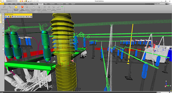
Trimble will release a new version of Trimble RealWorks, its all-in-one point-cloud software platform. The new version of Trimble RealWorks — featuring performance and user interface (UI) improvements — will be available for download June 19.
Changes include the following:
Batch processing workflows are now available to automate data processing for large datasets saving users time on projects.
New visualization and productivity tools include enhanced shading, improved registration automation and geometry editing. According to Trimble, the new tools enable customers to better understand project data and more easily create customer deliverables.
Enhanced multi-core processing for modern CPUs and added support for AMD Ryzen-based computers significantly reduces the processing time for registering and extracting scans.
Esri has launched the Africa GeoPortal, a comprehensive cloud-based platform that provides rich content and solutions from Esri and its partners.
The geoportal provides access to Esri’s ArcGIS Online service as well as geographic data and imagery for Africa.
The African Union, African Development Bank, other international agencies, nongovernmental organizations (NGO), academia, businesses and national government funds will be able to use the geoportal to address the most urgent development challenges — from economic development and climate adaptation to conservation and health care.
“Access to this Africa GeoPortal powered by the ArcGIS platform will provide my colleagues at the iLab, and others in the network of African Technology Hubs (AfriLabs), with the information and analytical capabilities that we need to make the most effective development interventions for our citizens and communities,” said Luther Jeke, Manager of iCampus at iLab Liberia.
The complimentary software-as-a-service technology is offered to all who are supporting African nations for positive economic, social and environmental outcomes — African citizens, NGOs, and international development agencies alike.
The geoportal offers access to spatial analytics capabilities and authoritative content for charting compelling, educational, informational, entertaining and beautiful maps of Africa, Esri said.
“We are deeply committed to helping the people of Africa discover, explore, and understand the vast information available to them through the power of maps,” said Jack Dangermond, Esri founder and president. “Through this service, we hope to provide our users with the benefit of ongoing developments and investments at Esri so they can foster missions to the best of their abilities.”
To learn more about the Africa GeoPortal and Esri’s commitment to supporting the global community in the quest for sustainability through better mapping and location intelligence, visit go.esri.com/africa_geoportal.
Trimble has announced version 4.1 of Trimble Business Center office software that enables surveyors and geospatial professionals to simplify the creation of cadastral, GIS, infrastructure inspection and tunneling deliverables.
With the version 4.1 update, GNSS field data from GIS receivers (including the Trimble Geo 7X) can now be post-processed within Trimble Business Center to achieve high-quality feature locations. This allows enterprise-level organizations the flexibility to integrate both GIS and survey data within the same project environment and then link the high-quality locations directly to their Esri geodatabase.
Version 4.1 also provides seamless integration with Trimble Access 2018 field software to improve field-to-office productivity using new cloud-based data synchronization and workflow task management capabilities.
Version 4.1 adds new cadastral capabilities including proportioning, map checking and CAD drafting tools that streamline the creation of survey plans, plots and survey engineering digital deliverables.
For infrastructure inspection, construction as-built verification and volumetric applications, new projected surface tools enable professionals to analyze and compare data captured in the field against design. Point clouds from the Trimble SX10, Trimble VISION instruments, 3D laser scanners and unmanned aircraft system (UAS) platforms can be used for slope monitoring as well as to perform accurate volumetric, deformation and cut/fill analysis for retaining wall, dams and mining applications.
A new optional Tunneling Module enables survey and engineering professionals to simplify their workflow and improve productivity to meet time-sensitive deadlines for tunnel construction projects. Tunnel designs can be created and exchanged with Trimble Access field software, enabling customers to easily stakeout tunnel elements in the field and quickly produce as-built analysis and reports in the office.
Location intelligence system introduced for nations in need of modernized land governance
Esri will join this year’s FIG Congress, hosted by the International Federation of Surveyors, taking place May 6–11 in Istanbul, Turkey.
At the annual event, Esri will showcase its new program for modernizing land administration systems tailored to the needs of developing countries and island nations.
Good land governance requires effective policies, efficient processes and institutions that can determine, record and disseminate information about the tenure, value and use of land. The new Land Administration Modernization Program allows land administration organizations in developing nations to meet these challenges and lay the foundation for economic success.
Esri’s program delivers an inexpensive, scalable platform that allows simple field capture, management and publication of parcel data in the cloud, or that can be implemented as an enterprise system meeting the needs of any modern land administration office.
The software is donated to eligible countries for four years from date of order, and includes maintenance updates and support from Esri.
At FIG Congress, Brent Jones, land records/cadastre industry manager at Esri, will host the workshop, “Modernize Land Administration Systems: Off-the-Shelf GIS Technology for Modern Cadastral Operations,” May 9, 11 a.m.–12:30 p.m., at Hamidiye Hall, Istanbul Congress Center.
The workshop will demonstrate how Esri’s ArcGIS platform is a complete, interoperable, open, and purpose-built system for cadastral operations to improve efficiency, manage data integrity, and share data across organizations and with the public. ArcGIS delivers necessary capabilities ranging from fit-for-purpose to enterprise cadastral systems, whether the aim is improve data quality, increase throughput, or enhance spatial accuracy.
Bentley Systems, a global provider of comprehensive software solutions for advancing infrastructure, has acquired Plaxis, provider of geotechnical software, based in Delft, Netherlands.
Bentley has also agreed to acquire soil engineering software provider SoilVision, based in Saskatchewan, Canada.
The acquisitions, with Bentley’s market-leading borehole reporting and data management software gINT, serve to make Bentley a complete digital source for geotechnical professionals.
With the acquisitions, building information modeling (BIM) advancements can be extended to the essential subsurface engineering of every infrastructure project.
Projects necessarily begin with geotechnical surveys and sampling, captured with gINT for versatile documentation and reporting.
Next, professionals perform engineering related to soil properties, soil behavior, and groundwater flow using SoilVision’s SVOFFICE applications, supplemented by Plaxis’ offerings.
Then, soil-structure interaction is analyzed through Plaxis’ design, simulation, and engineering software (for example, PLAXIS 2D, PLAXIS 3D).
The new opportunity, by way of digital workflows enabled through Bentley’s comprehensive modeling environment, is for geotechnical applications to be integrated with Bentley’s structural applications (such as STAAD, RAM and SACS) for unprecedented geo-structural engineering performance.
As changes may occur in owner requirements, structural strategies or site conditions (continuously surveyed through UAVs and Bentley’s ContextCapture for reality modeling), geotechnical analysis could be continuously applied for improved outcomes, as managed through ProjectWise collaboration services.
For today’s infrastructure demands, geotechnical considerations are coming to the fore.
Urbanization, for instance, drives growth both vertically and underground, with emphasis on the capacity of foundations and tunnels. And new infrastructure projects of every type depend upon constructed dams, embankments, dikes, levees and reservoirs to improve their resilience.
Moreover, new asset types such as offshore wind turbine structures require new geotechnical analysis capabilities, in this case to be accomplished with Plaxis’ forthcoming MoDeTo software.
Because infrastructure assets are crucially linked to subsurface environs, they are vulnerable to geo-environmental risks including seismic activity, subsidence and weather impacts. Leveraging new digital workflows which incorporate real-time monitoring and analytics during infrastructure operations, geotechnical professionals can play the increasingly valuable role they deserve in achieving geo-environmental resilience.
“My colleagues and I welcome our new teams from Plaxis and SoilVision, which have in common a zeal for applying science for better engineering practice,” said Greg Bentley, Bentley Systems CEO. “Dr. Ronald Brinkgreve from Plaxis and Dr. Murray Fredlund, founder of SoilVision, exemplify this. I believe that every geotechnical engineer has benefitted from Plaxis’ continuous advancement, in scope and quality, of tools for their discipline to add value. With a professional and dedicated management team led by Jan-Willem Koutstaal, Plaxis has become one of the most successful software businesses I have ever seen.”
Bentley added, “While most infrastructure engineering disciplines converged around intuitive 3D models, geotechnical applications seem to have followed a less graphically intensive development path, and so have remained isolated from cross-discipline workflows. This ‘disconnected’ mindset prevailed even while Plaxis, SoilVision, and gINT mainstreamed 3D innovations. Our BIM platform’s comprehensive modeling environment will finally embrace the geotechnical profession in digital workflows for every infrastructure project and asset.”
Tony O’Brien, global practice leader for geotechnics for Mott MacDonald, said, “PLAXIS is one of our core analysis tools being used across our global geotechnics practice. When used by experienced specialists, PLAXIS can analyze many of our most complex ground-structure interaction problems. In Bentley’s hands, we have high expectations that we can accomplish more through digital workflows made possible through integration of PLAXIS technology with Bentley’s comprehensive modeling environment—workflows that are compatible with Mott MacDonald’s commitment to connected thinking and solving complex infrastructure challenges.”
Through the new Esri Official Statistics Modernization Program, the company will donate perpetual use licenses for ArcGIS software to eligible official statistical agencies in least developed countries (LDCs) and small island developing states (SIDS).
The program provides access to Esri ArcGIS Enterprise technology in support of the upcoming census counts that all countries will undertake during the Census, 2020 Round.
The data collected as part of these census counts is crucial to nations for competing on the global stage. By using authoritative methods of collection and the cutting-edge mapping and analytics tools that Esri is donating, developing nations can gain an advantage in making data-driven policy decisions suited to a globalized economy.
The Esri Official Statistics Modernization Program provides access to the same software that hundreds of thousands of Esri customers—from public agencies to private enterprises—rely on every day to run their organizations. Esri will also provide guidance and best practices workflows at no cost so countries can implement their own systems to help with collecting data for their census.
“Population and housing censuses are big efforts for countries, especially those that may not have the resources readily available,” said Linda Peters, Esri global business development manager. “These censuses are important, as the data collected is one of the primary sources of information needed for formulating, implementing, and monitoring policies aimed at inclusive socioeconomic development and sustainability.”
Modernization efforts around census activities are helping countries leapfrog from paper-based workflows to digital and mobile ones. The United Nations (UN) expert group that specifically focuses on integrating statistical and geospatial information advised all countries to use a Global Statistical Geospatial Framework (GSGF) to aid in the modernization program.
This framework requires nations using GIS technology like Esri’s to ensure the implementation of up-to-date capabilities like data accessibility, ease of use of the technology, and the conversion of addresses into geographic coordinates on maps (geocoding).
The Esri Official Statistics Modernization Program was announced at the GIS for a Sustainable World conference in Geneva, Switzerland, co-organized by Esri and the UN. For more information on the program and nation eligibility, visit go.esri.com/officialstatisticsprogram.
Boundless Anywhere is a new mobile application for enterprises needing to collect and distribute location information from handheld devices and tablets, available for iOS or Android.
With Boundless Anywhere, organizations can collect data in the field and store it instantly in a database. Collected data can then be visualized on clients such as desktop GIS, web and mobile. With real-time access to location-based data, the entire organization can now accomplish work faster and more efficiently.
“Mobility is at the heart of today’s technology, and the rapid proliferation of smartphones and tablets in recent years has had a profound impact on the GIS industry,” said Anthony Calamito, chief geospatial officer at Boundless. “The ability to access all kinds of data — including location data — from the palm of our hands at any given time or place has become essential. With this extended offering, Boundless offers mobile capabilities that empower users to do more while on the move.”
With Boundless Anywhere, users of the Boundless enterprise GIS platform can collect geospatial data wherever they are and use maps to engage a community, validate data, make observations, report, respond and communicate in real-time. The new solution simplifies field collection workflows and improves the accuracy of geospatial data, saving time and money.
Users are able to capture new data and edit or delete existing data with or without an internet connection, and can sync instantly once they are back online. Updates and edits are instantly available on Boundless Exchange, where the entire team can analyze and share findings with the rest of the organization.
Key advantages:
Collaborate in real-time to make faster decisions. View mobile edits instantly on the web, making it easy to pull data into your GIS for mapping, analysis, and reporting.
Ground-truth data to improve accuracy. Take expensive transcription errors out of the equation. Mobile workflows modernize field collection away from clipboards and cameras, ensuring data collected on-location is current and accurate.
Empower responders to collect, even when offline. A good network connection is never guaranteed in the field – the Boundless Anywhere solution lets you edit GIS data in even the most remote areas and sync it when you’re back online.
GIS apps don’t have to be cumbersome. Collect GIS data and photos in a straightforward interface that’s easy to use and can turn your entire team into data collectors.
Boundless solutions are built on open GIS technology and APIs that generate actionable location intelligence across third-party apps, content services and plugins for enterprise applications.
LizardTech, a provider of software solutions for managing and distributing geospatial data, will launch Version 10 of its GeoExpress data manipulation and compression software at the 2018 GEOINT Symposium. GeoExpress 10 includes significantly expanded lidar data handling capabilities and improved interface communication.
LizardTech will demonstrate GeoExpress 10 in booth #1245 at the GEOINT Symposium, which is being held April 22-25, 2018, at the Tampa Convention Center in Tampa, Florida.
GeoExpress is LizardTech’s flagship software product originally created to enable geospatial professionals to manipulate digital satellite, aerial and UAV images and losslessly compress them to industry-standard MrSID or JPEG2000 files for more efficient use.
The addition of lidar handling in 2015 and 2016 releases gave GeoExpress the ability to natively compress lidar data to MrSID and LAZ formats with no loss of data content, saving up to 75% on storage and processing time, as well as support for high-density BPF point clouds.
“Users can do a lot more with their lidar data in GeoExpress 10,” said Toby Martin, LizardTech vice president, Development and Strategy.
In past versions of the software, GeoExpress performed only basic compression and mosaicking of lidar point clouds. The new version enables users to reproject lidar files into different coordinate systems and crop the data to create smaller files.
Individual files or single tiles within a mosaic may be cropped to a desired area of interest for easier and faster processing. Additionally, GeoExpress 10 allows the user to crop by elevation, adding a third dimension to spatial image management.
“You can use the elevation cropping function to create point clouds of just the mountain peaks in an area, for example, if you are planning a high-elevation project,” said Martin.
In GeoExpress 10, users will also find the overall experience of interacting with their data sets is more intuitive thanks to enhanced information and communication from the software. Users may now select the data sets they want to mosaic together, and the software presents a selection of processing options which may be applied to those files.
Another general upgrade in the new version is the ability to pause and then re-start a processing task without losing any progress already achieved. In the past, a task could only be stopped and started again from the beginning once it had been initiated, which for extremely large processing jobs may take significant resources to complete.
Other enhancements to GeoExpress 10 include:
compatibility with LZW compressed TIFF files commonly output from Pix4D software.
addition of Esri projections to the Reprojection Manager.
addition of rectangular cropping around a center point.
shape cropping using Google Earth KML files.
In addition to GeoExpress 10, LizardTech will showcase its complete line of geospatial products at GEOINT 2018:
Express Server software for high-performance delivery and publication;
the recently updated GeoViewer software, which is the fastest way to view MrSID and JPEG 2000 imagery; and
the recently released Portfolio 2017 digital asset management solution, which makes it easy to organize, access and share geospatial imagery alongside associated graphic and digital files.


 His success did not end there. Based on his experiences fighting criminals on the streets and fighting change in the antiquated police system, he wrote the book,