The 2015 Blue Marble User Conference (BMUC) will take place in Arlington, Va., on Tuesday, Oct. 6. The annual event provides industry experts, Blue Marble software users, product developers, and applications specialists with a forum for sharing experiences and exchanging ideas on the current and future developments in the Global Mapper and Geographic Calculator platforms.
Blue Marble’s geospatial data manipulation, visualization and conversion solutions are used worldwide by thousands of GIS analysts at software, oil and gas, mining, civil engineering, surveying, and technology companies, as well as governmental and university organizations.
Following the success of last year’s User Conferences in Calgary and Houston, the 2015 conference is being consolidated into a single venue, just across the Potomac River from Washington, D.C. As with previous conferences, this event offers a unique and invaluable opportunity to learn about the latest innovations in Blue Marble’s suite of GIS applications; to hear from industry experts about their experiences working with Blue Marble technology; and to network with representatives from a variety of business sectors and government departments.
Over the years, the BMUC has provided GIS professionals with the opportunity to learn how Blue Marble’s innovative geospatial applications are streamlining GIS operations across many industries and to learn how others are maximizing their investment in the software. One of the most popular segments in the BMUC agenda is case studies that demonstrate the inherent flexibility of the software and its ability to meet the challenges of today’s GIS data processing and management tasks. The 2015 event will continue this trend with industry experts from the U.S. Geological Survey, the U.S. military and prominent engineering and survey firms.
“BMUC is the most important event on our calendar every year,” stated Patrick Cunningham, Blue Marble president. “Not only does it allow us to showcase some of the latest advancements in our applications, but it also provides us with an ideal forum in which to engage with our most dedicated users and to garner their input on the continued development of Blue Marble products.”
Space at BMUC is limited and attendees are asked to pre-register to guarantee a spot at this event.
ThinkGeo has released version 9.0 of Map Suite, its full line of GIS software components for .NET developers. This major milestone refreshes ThinkGeo’s Map Suite product line with a wide variety of enhancements. It includes Aerial Imagery for the Map Suite World Map Kit Online, Xamarin.Forms in the Map Suite iOS and Android Editions, support for Google Traffic and Street View in the Map Suite Web Edition, and many performance and stability improvements.
Map Suite World Map Kit Online now features beautiful aerial imagery. The all-new Hybrid View combines ThinkGeo’s detailed street-level world-wide maps with aerial imagery to provide the best of both worlds.
Xamarin.Forms has been added to Map Suite iOS and Map Suite Android Editions. Developers are now able to rapidly create maps for iOS and Android devices while sharing the vast majority of the code.
Another notable feature in ThinkGeo’s Map Suite 9.0 is the addition of Google Traffic and Street View to the Map Suite Web Edition. In the Map Suite MVC Edition, data binding and action triggers have been designed in order to simplify development. MapBox tile overlay support in the Map Suite iOS and Android Editions provides another option to the existing Google, Bing, and OpenStreetMap basemaps.
The 9.0 update includes new builds of all of Map Suite’s editions, including WebAPI, iOS, Android, Desktop (WinForms), WPF Desktop, Web (WebForms), MVC, Silverlight, Services and WMS Server Editions, as well as the Map Suite Geocoder and the Map Suite Routing extension. Many performance and stability improvements have been implemented across the Map Suite GIS product range. Complete change logs are available at the ThinkGeo Wiki, the company’s official online source for Map Suite documentation and learning material.
ThinkGeo’s next major release of Map Suite, version 10.0, is expected in the summer of 2016, but developers can expect to start receiving beta features in advance via the daily builds which can be downloaded directly from the ThinkGeo Product Center.
For more information about Map Suite, or to download the ThinkGeo Product Center and access free 60-day evaluation of each Map Suite 9.0 product, visit ThinkGeo’s website. All evaluators and users can discuss and receive support for their Map Suite applications at ThinkGeo’s Discussion Forums.
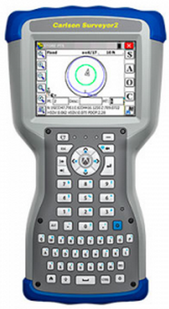
Carlson Software has released the Carlson Surveyor2, the newest model in its Carlson Surveyor line of data collectors. The Surveyor2 is paired with Carlson’s software to provide a powerful, complete solution for surveying, stake out, construction layout, and GIS mapping, the company said.
Designed and manufactured by Juniper Systems, the Carlson Surveyor2 is built to withstand the harshest conditions, with an IP68 rating for dust and water and superb durability when dropped or exposed to cold, heat or other rugged environments.
With minimal increase in weight compared to the original Surveyor, the Surveyor2 offers greater memory and data storage, a faster, 1.0-GHz processor, and significantly improved Bluetooth range — up to 1,500 feet. The data collector also features a new QWERTY keyboard with large buttons for easy data entry, enhanced battery power with 20+ hours of runtime, and a larger, brighter display, providing excellent visibility in any lighting conditions.
The Surveyor2 runs Windows Embedded Handheld 6.5.3 and can be purchased with Carlson SurvCE 4.0, Carlson’s powerful data collection software. SurvCE offers exceptional usability, with a tab-based menu and advanced graphics for easy-to-use functionality, the company said.
“The Surveyor2 and SurvCE together create an advanced solution for surveying applications, while maintaining simplicity and ease-of-use,” said Debbie Trolson, geomatics market manager at Juniper Systems. “The Surveyor2 offers significant improvements over its predecessor, providing surveyors with the features they need to perform their work productively and effectively.”
Avineon, Inc., a global provider of information technology and engineering support services, will be presenting its complete portfolio of geospatial offerings at the 2015 Esri User Conference in San Diego, Calif., on July 20-24. A long-time Esri Business Partner, Avineon develops and implements a wide variety of geospatial services.
Avineon will be making presentations and providing demonstrations in booth #1015.
Avineon offers geospatial products and services to Esri clients in numerous industries, including energy water, and communications utilities and all levels of local, state, and federal government agencies. Avineon specializes in assuring and enhancing the quality of existing data through extensive data conversion, migration, conflation, and enrichment services. In addition, the firm extracts new data sets, such as orthoimagery, digital elevation models (DTMs), and 3D visualizations from aerial photography and LiDAR acquisitions.
Avineon also provides support for version upgrades and cloud migration, software testing and help desk staffing. In the web/mobile arena, Avineon has a long history of creating custom applications and server extensions for outage management, field workforce management, wire down monitoring, and other efficiency-enhancing applications. When consolidating to a single system is not practical, Avineon implements cross-platform technologies that normalize spatial data and establish data governance programs across diverse GIS data sets.
“Avineon has been working closely with Esri for more than 10 years to create innovative solutions for GIS clients worldwide,” said Joel Campbell, Avineon’s vice president of commercial systems. “We invite all Esri Conference attendees to visit our booth and learn how Avineon can make your geospatial content more intelligent.”
Leica Geosystems announced that it is taking the first step toward bringing live-streamed intelligent cloud-based imagery into all field applications, beginning with the launch of the Leica Nova MS60 MultiStation, Leica Nova TS60 Total Station, Leica Viva TS16 Total Station and Leica Zeno 20 handheld.
Geospatial professionals in the U.S. and Canada who invest in these new solutions can become part of this pioneering effort and add even more intelligence to their dataset with up to one year of introductory free access to georeferenced imagery from the Hexagon Imagery Program (HxIP), the company said.
A high-quality, accurate and professional dataset, HxIP imagery is 30-cm (1-foot) resolution, with set specification and accuracy standards and a regular refresh schedule. The natural color RGB backdrop imagery (tile cache) is fast and easy to access and gives context to survey and construction maps and overlays, Leica Geosystems said. All content is captured using Leica Geosystems airborne sensors for the highest reliability.
Access to HxIP imagery adds spatial and contextual awareness to surveys, enables better planning and decision-making for more efficient and productive time onsite, and eliminates the need to georeference data to the basemap during post-processing, the company said. Through Leica Infinity software, users can access HxIP imagery to view field measured data and imported design data in the office.
Users can also prepare job data with the HxIP imagery and then clip and store georeferenced images that can be exported to the new Leica Captivate field software for use as background imagery and basemaps on the newest robotic total stations. The imagery can also be live-streamed to the Leica Zeno 20 handheld.
The georeferenced HxIP airborne imagery is available to everyone on a subscription basis through the cloud via multiple content service providers, including Esri’s ArcGIS Marketplace, Hexagon Geospatial’s Power Portfolio and Valtus Imagery Services. Complimentary access to live-streamed HxIP image tiles is being offered through June 2016 to customers in the U.S. and Canada that have an active Leica Infinity Customer Care Package (CCP) or that purchase a Leica Zeno 20 handheld.
“We’re quickly moving toward a world in which every geospatial sensor will have cloud-based access to real-time, high-quality imagery for invaluable survey intelligence,” said Ken Mooyman, president of Hexagon Geosystems NAFTA. “The integration of HxIP with Leica Infinity, Captivate and the Leica Zeno 20 in North America is the first step in bringing that rich, detailed imagery to users where and when it is available so they can be part of leading the way into the future.”
The European Space Agency (ESA) on June 23 successfully launched its Sentinel-2A satellite, the second satellite to be launched in Europe’s Copernicus environment monitoring program. Above is a video of the Sentinel 2A lift-off.
“We are very pleased to have such a talented new player join the team in watching Earth from space,” said Suzette Kimball, acting U.S. Geological Survey (USGS) director. “The aptly named Sentinel mission will help sharpen our focus on changes in Earth systems and contribute further insight to a great many global challenges at international to local scales, including food security, forest and wildlife conservation, and disaster response.”
NASA has published a comparison of Sentinel-2A and Landsat bandwidths.
Sentinel-2 imagery is expected to supply valuable parallels and counterparts to Landsat imagery provided by the United States. Before Sentinel-2A launched, USGS and ESA staff worked together at length to ensure that Sentinel-2 data would be as compatible as possible with Landsat data.
First launched by NASA in 1972, the Landsat series of satellites has produced the longest, continuous record of Earth’s land surface as seen from space. Landsat images have been used by scientists and resource managers to monitor water quality, glacier recession, coral reef health, land use change, deforestation rates, and population growth.
Landsat is a joint effort of USGS and NASA. NASA develops remote-sensing instruments and spacecraft, launches the satellites, and validates their performance. USGS develops the associated ground systems, then takes ownership and operates the satellites (since 2000), as well as managing data reception, archiving, and distribution. Landsat data were made available to all users free of charge under a policy change by the U.S. Department of the Interior and USGS in late 2008.
Sentinel-2A in the gantry before launch.
“We are also pleased that a free and open data policy has been adopted for users of Sentinel data,” Kimball added. “Free, open access to Landsat and Sentinel-2 data together will create remarkable economic and scientific benefits for people around the globe.”
Designed as a two-satellite constellation — Sentinel-2A and -2B — the Sentinel-2 mission carries an innovative wide swath high-resolution multispectral imager with 13 spectral bands. However, it will not fully duplicate the Landsat data stream, which includes thermal measurements. Sentinel-1A, a satellite with radar-based instruments, was launched April 3, 2014.
Once it is fully operational following several months of on-orbit testing, Sentinel-2A alone could provide 10-day repeat coverage of Earth’s land areas. With Sentinel-2A data added to the eight-day coverage from Landsat 7/8 combined, users can look forward to better-than-weekly coverage at moderate resolution. Repeat coverage capabilities will further increase with the planned launch of a second Sentinel-2 satellite (Sentinel-2B) next year.
From our July issue comes this showcase featuring products for surveyors, geographic information systems (GIS) professionals, field workers, and anyone who is looking to expand the capabilities of their smartphone or tablet.
Dedicated Survey/Geospatial
Three-Accuracy Series
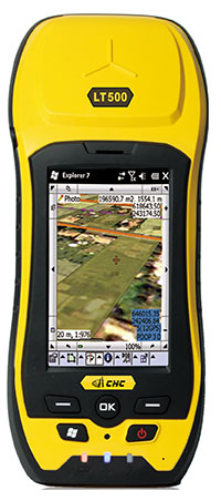
The LT500 series of handheld GPS receivers, LT500H/T/N, covers three accuracy ranges from sub-meter to centimeter. It is a cost-effective full GNSS positioning solution for survey, construction and GIS professionals.
Powered by the Windows Embedded Handheld 6.5 operating system, the LT500 is accurate, rugged and versatile. User productivity is enhanced with the built-in gyroscope, an innovative laser plummet for positioning the accurate handheld receiver over a point, an E-compass for showing the direction and G-sensors for leveling. The LT500 series comes bundled with software including SurvCE, DigiTerra and MapCloud. The LT500H has120 channels (GPS L1/L2/L2C, GLONASS G1, G2, BeiDou B1 and Galileo E1), the LT500T has 220 channels (L1, G1, B1), and the LT500N has 12 channels (L1).
The all-in-one TRIUMPH-LS by JAVAD GNSS combines a high-performance 864-channel GNSS receiver, all-frequency GNSS antenna, and a modern featured handheld. The 864 all-in-view channels include Galileo E1/E5A/E5B, GPS L1/L2/L5, GLONASS L1/L2/L3, QZSS L1/L2/L5, BeiDou B1/B2 and SBAS L1/L5.
More than 100 channels are dedicated to continuous interference monitoring, allowing safe GNSS operation in a city, airport and military environment.
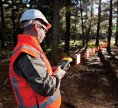
The GEOmeter MX system is designed to gather GIS information in heavily wooded areas, with object description, area coordinates and measurement time grasped automatically. The system consists of the GEOsat MXbox receiver, a combination antenna, a PDA such as the Trimble Recon or the Handheld Nautiz X8, and GEOfield software for mobile GIS.
The Mxbox receiver is a Hemisphere multi-constellation GNSS OEM board with GPS, GLONASS, BeiDou, Galileo and QZSS, plus code- and carrier-phase tracking for increased positioning accuracy and availability. The GEOfield software offers reliabe recording, representation and processing of geodata. Measurement quality is indicated in the field with statistics and graphics, in either German or English.
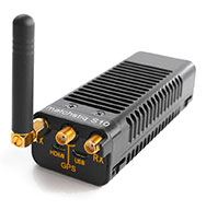
The Matchstiq S10 is a software-defined radio (SDR) platform. It provides increased RF flexibility, RF performance and signal processing capacity in a small package. The Matchstiq S10 platform combines the Epiq Solutions’ Sidekiq SDR with a quad-core processor system running Linux. The Sidekiq MiniPCIe SDR card provides an independently tunable RF transmitter and receiver covering 70 Mhz to 6 Ghz with an RF bandwidth up to 50 Mhz, plus FPGA. The Matchstiq S10 platform also integrates GPS, Gigabit ethernet (with PoE), USB 2.0 OTG, HDMI and real-time clock in a very small form factor package.
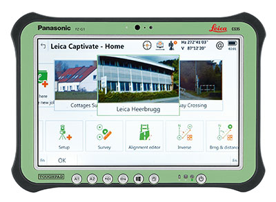
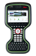
Leica Captivate software provides a 3D view for the Leica Viva GNSS, merging the overlay of measured points, 3D models and point clouds into a single view.
Using Leica Captivate, users can capture and manage complex data with the touchscreen on both the Leica CS20 handheld controller and the CS35 tablet.
The CS20 runs on Windows EC7 and is IP68 and MIL-STD-810F rated. It has a 5-inch WVGA color touchscreen that allows for comfortable and quick data processing and a fully integrated radio and antenna for long range robotic total station control. The CS35’s 10.1-inch screen is visible in all conditions. It runs on Windows 8.1 Pro, enabling workers to take their office into the field. It is IP65 and MIL-STD-810G rated.
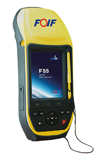
The FOIF F55 series GIS handheld comes in two models: F55-A and F55-B. The onboard software FOIF SuperGiS allows users to conduct field mapping with powerful functions for data collecting, data editing and data querying.
The F55 measures 234 x 99 x 56 mm and weighs 895 grams. It has an IP65 rating for water and dust protection. The F55-A supports four GNSS (GPS, GLONASS, Galileo and Beidou) as well as SBAS, and can search for up to 120 channels. The F55-B supports GPS and SBAS and provides 12 channels.
With Differential GPS, the F55-A has an accuracy of 0.4 meters, and the F55-B has an accuracy of 0.5 meters. RTK surveying on the F55-A obtains high precision of 1 cm + 1 ppm. Real-time correction service and post-processing are available.
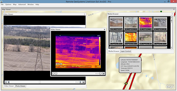
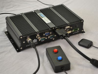
The geoDVR Gen2 is an advanced multi-channel high-definition/standard-definition geospatial digital video recorder designed for aerial and mobile environments.
Unlike a DVR, the rugged geoDVR permanently embeds videos with important GPS location, time and other data — the GPS metadata remains intact even when a video is edited. Most video cameras and gyro-stabilized gimbals can be connected to the geoDVR for recording of HD or geospatial video files.
Video files created by the geoDVR can be analyzed in the RemoteGeo LineVision suite of mapping applications, including tools for Google Earth, Esri ArcGIS, PLS-CADD and the LineVision Cloud. The administrative dashboard allows for monitoring up to four video streams in real-time.
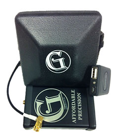
The G1-m1 receiver is part of the G1 family of products from Geomatics USA. The G1 system is scalable from a single-frequency semi-mobile receiver — for control networks and some semi-kinematic mapping applications — to a dual-frequency network RTK solution. It was designed to be lightweight, accurate and portable, especially suited to building a system for travel; for example, all the G1-m1 components, including tripod, will easily pack into a baseball-style bag for transport. The G1-m1 offers centimeter and sub-foot accuracy (centimeter-level accuracy is possible for OPUS-compliant static sessions).
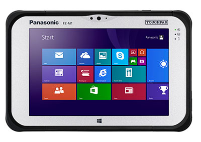
The Panasonic Toughpad FZ-M1 is a thin, light and rugged 7-inch Windows tablet with dedicated GPS — the u-blox Neo M8 series — as an option. The FZ-M1 is built to enable mission-critical mobile worker productivity. Powered by Windows 8.1 Pro and a choice of two Intel processors, it features a long life, user-replaceable battery and a daylight-readable, high-sensitivity multi touchscreen for use with heavy gloves. With a broad range of configuration options, the customizable Toughpad FZ-M1 is rated MIL-STD-810G and IP65, resistant to five-foot drops, weather, dust and water.
Trimble’s RTX technology-based correction services — Trimble CenterPoint RTX, Trimble RangePoint RTX and the new Trimble ViewPoint RTX — are now available on Trimble Geo 7X handhelds.
Trimble RTX technology provides compatible GNSS receivers with correction services that significantly improve accuracy and reliability in obtaining positions worldwide. Operational efficiency and productivity in the field is improved by delivering real-time DGNSS corrections directly to the Trimble Geo 7X handheld.
The handheld solution is designed for industries such as utility companies, municipalities and environmental management agencies, in which workers are highly mobile and require a reliable, flexible data-collection and asset management solution.
A choice of RTX correction services ranging from 4 centimeters to submeter-level horizontal accuracies is available.
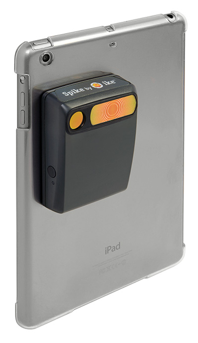
The Spike device and Spike mobile app allow users to measure an object by capturing a photo from a smartphone or tablet. From the photo, users can capture real-time measurements, including height, width, area, length and target location. Location data includes latitude, longitude and altitude. Spike is useful for construction, inspection, safety, advertising, real estate, insurance and government applications.
Measurements and location data are saved with the picture and can be shared via email as a PDF, XML and KMZ. KMZ files can be imported into GIS tools such as ArcGIS and Google Earth. The photo can be referenced via the Spike app to take new measurements or view original measurements.
The Spike device pairs with an Android or Apple iOS smartphone or tablet via Bluetooth. Its laser rangefinder works with a smartphone’s camera, GPS, compass and Internet connection.
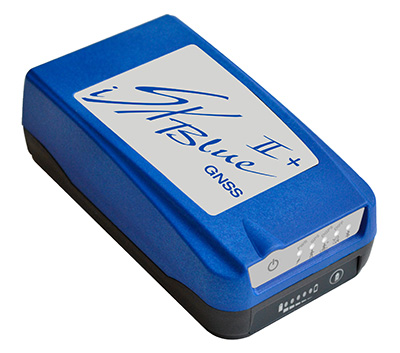
The iSXBlue II+ GNSS is a palm-sized receiver that delivers real-time, high-accuracy performance using GPS+GLONASS satellites and free SBAS corrections for an iPad or iPhone. Its battery-powered lightweight design is for a variety of mapping applications including GIS, forestry, mining, utilities, agriculture, surveying and environmental. It delivers high accuracy in real time without the need for post-processing or another correction source when SBAS (WAAS, EGNOS, MSAS or GAGAN) are available. Using both GPS and GLONASS satellites, the iSXBlue II+ GNSS will work where GPS receivers struggle, such as in the forest, around buildings and in other difficult mapping environments. The L1/G1, GPS+GLONASS receiver has 372 channels.
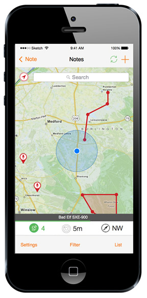
TerraGo Edge allows organizations to collect data and share field information on their smartphones and tablets. TerraGo Edge replaces traditional GPS handheld devices with a mobile cloud-based solution. Users can collect GPS data points at any accuracy level, either by using the onboard GPS on a smartphone or by attaching a centimeter-level GPS receiver to a mobile device.
TerraGo Edge 3.6 features enhanced support for high-accuracy GPS receivers such as EOS and SXBlue on both iOS and Android, as well as better mapping features, basemap sources and integration with Google Earth.
For managers, TerraGo Edge provides a real-time dashboard for monitoring field users and data collection.
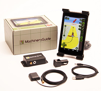
MachineryGuide enables a tablet or smartphone to be used as a precision tractor GPS system. The MachineryGuide Android guidance program functions as a precision farming application using an antenna capable of receiving and processing EGNOS and WAAS corrections. It can be used for any farming activity that is done by tractor or other agricultural machinery, including fertilization, manure application and spraying. It even can be used for land measurements.
MachineryGuide sells the software separately; a GNSS receiver + antenna separately; and a package bundle that includes software, GNSS receiver and antenna. The receiver uses GPS, GLONASS, SBAS and QZSS signals for a position accuracy of 2.5 meters CEP.
The TomTom Bandit Action Camera allows creation of videos within moments of the action. It comes with a built-in media server, eliminating the need to download footage before editing. The camera works with a companion app, making it possible to create and share videos in a matter of minutes — by shaking a smartphone.
The TomTom Bandit Action Camera is equipped with in-camera motion and GPS sensors to automatically find and tag footage based on speed, altitude, G-force, acceleration and heart rate. Highlights can also be tagged manually with a tagging button on the camera or the remote control.
The Forerunner 225 integrates optical heart-rate technology by Mio and features a colorful graphic interface showing runners their zone and beats per minute at a glance. A built-in accelerometer provides distance and pace data for indoor running with no need for a separate foot pod. To keep runners active between workouts, it doubles as an activity tracker, counting steps, calories and distance.
When paired with a compatible smartphone, the Forerunner 225 will automatically upload a completed run to the Garmin Connect Mobile app for post-run analysis and sharing on social media sites. Runners can also use live tracking to allow friends and family to follow along during training or on race day to see stats in real time.
High-performance digital camera maker Point Grey has added a new 12 MP CCD model to its Grasshopper3 USB3 Vision camera line. With high-resolution CCD image quality, high-dynamic range, and USB 3.0 interface, the Grasshopper3 is suited for a variety of demanding applications including industrial inspection, 3D scanning, microscopy and mobile mapping.
The Grasshopper3 GS3-U3-120S6 models are based on color and monochrome versions of the 1-inch Sony ICX834 global shutter CCD sensor, which features 3.1 micron pixels and 4242 x 2830 image resolution running in dual-tap at 7 FPS. The ICX834 device uses Sony’s EXview HAD CCD II pixel architecture with improved quantum efficiency and near infrared response (NIR).
EXview HAD CCD II also enables smaller pixel sizes while maintaining excellent imaging performance. This allows the high-resolution ICX834, with its 1-inch optical format, to be integrated into compact C-mount cameras like the Grasshopper3, and used with smaller, lower cost C-mount lenses.
Grasshopper3 Like all Point Grey USB 3.0 cameras, the Grasshopper3 uses a proprietary USB 3.0 link layer and frame buffer-based architecture for optimal performance and reliability. The Grasshopper3 uses an advanced image processing pipeline to enable color interpolation, look up table, gamma correction, pixel binning and USB3 Vision support.
“We’re excited to continue expanding our Grasshopper3 USB3 Vision family with even higher resolution sensors,” says Michael Gibbons, Director of Sales and Marketing at Point Grey. “This new 12 MP Grasshopper3 camera is Point Grey’s highest resolution machine vision camera to date. The ultra HD 4K Sony ICX834 CCD sensor achieves a higher sensitivity in the near infrared range (NIR) and offers better price performance than other high resolution cameras on the market.”
The Grasshopper3 GS3-U3-120S6 is list priced at $3695/€2795 and is available to order now from Point Grey, its network of distributors and the online store (for North American, EU and Australian customers).
The United States Geospatial Intelligence Foundation (USGIF) announced the six recipients of its 2015 Awards Program on the main stage at the GEOINT 2015 Symposium, being held this week in Washington, D.C. The USGIF Awards Program annually recognizes the exceptional work of the geospatial intelligence tradecraft’s brightest minds.
“Each year as the nominations come in, we are always amazed by the exceptional work of the individuals and teams from government, military, industry, and academia being submitted for consideration,” said Kevin Jackson, chair of the USGIF Awards Subcommittee. “The opportunity to review the dozens of nominations and to understand the significance of your accomplishments and the impact of your contributions to the community, our country, and the world — which most likely never make the news—is truly humbling. The 2015 USGIF Award winners represent a community that we should be very proud to be a part of.”
The 2015 USGIF Award winners are:
Military Achievement Award: Air Force/Director for Intelligence, Surveillance, and Reconnaissance Interoperability(AF/A2I), Surveillance Intelligence Reconnaissance Information System (SIRIS) Team
SIRIS is a government-owned, high-performance, web-based capability that enables open observation, lightweight visualization, and game-changing collaboration for dynamic mission planning and execution across multiple networks. SIRIS collaboration is conducted via a real-time, integrated display of correlated and fused data from National Reconnaissance Office joint collaboration cells, allowing tactical operators to create a tailored, user-defined operational picture. SIRIS reduces fratricide, protects noncombatants and increases combat capability, and saved valuable fire-fighting time during the California rim wildfire. SIRIS is managed by A2 Innovations Director James “Snake” Clark and was created by Chris McDonald and Tim Petronello.
Government Achievement Award: U.S. Army Geospatial Center
In late 2012, months of drought left water levels along a 180-mile stretch of the Mississippi River as much as 20 feet below normal, exposing rock pinnacles in the navigation channel and restricting barge traffic from St. Louis, Mo., to Cairo, Ill.—essentially halting commerce along the Mississippi River. The U.S. Army Corps of Engineers is charged with keeping the river safe and navigable, and in this case needed to provide frequent updates to the White House on the progress of removing the pinnacles to restore navigation. The majority of geospatial products, although very accurate, were too complex for executive-level briefings. In a short timeframe, a team of Army Geospatial Center personnel synthesized the information gathered by the Corps and created geospatial products that enabled the President to quickly understand the problem and how it was being remedied.
Industry Achievement Award: George “Guy” Thomas, C-SIGMA, LLC
George “Guy” Thomas is a former U.S. science and technology advisor for maritime domain awareness and father of space-based automated identification systems (AIS). He also founded the Collaboration in Space for International Global Maritime Awareness (C-SIGMA) organization. Space-based AIS is changing how the maritime world operates by adding global transparency to operations. C-SIGMA works to increase safety and security in the maritime domain as well as protect the maritime environment and resources worldwide. Thomas’ 40-year career in surveillance includes positions with the U.S. Navy, Air Force, and Coast Guard, as well as with industry and Johns Hopkins University’s Applied Physics Laboratory. He led the introduction of both the Navy’s EP-3E and the Air Force’s RC-135W—the first reconnaissance aircraft with mission-system computers.
USGIF CEO Keith Masback (right) presents Bosarge with the USGIF Academic Research Award.
Academic Research Award: George Stanley Bosarge, University of South Alabama
George “Stan” Bosarge is senior research laboratory manager for the Fisheries Ecology Lab of the Dauphin Island Sea Lab, as well as the benthic habitat assessment program manager for the University of South Alabama’s department of marine sciences. Bosarge’s research is centered on a large-scale and long-term fisheries assessment project called the Fisheries Independent Ecosystem Survey. It’s designed to assess post-oil spill red snapper population recovery and the spatial relationships of red snapper to artificial and natural reef habitat off coastal Alabama. In 2016, he will join the Northeastern University faculty to teach a class on free and open-source GIS desktop applications in the university’s geographic information technology program.
Academic Achievement Award: Professor Dorota A. Grejner-Brzezinska & Dr. Charles Toth, Ohio State University
In the past 15 years, professors Dorota Grejner-Brzezinska and Charles Toth of the Ohio State University have significantly influenced the future of geospatial intelligence by advancing state-of-the-art geospatial data acquisition and processing technologies. Their most significant achievements include pioneering work on high-accuracy, direct sensor georeferencing algorithms and methodology; developing state-of-the-art sensor error models; developing novel compression technology for LiDAR data; and introducing an innovative and automated waveform processing method to support better point cloud generation and land-cover classification. This is the second time the duo has received a USGIF award, the first being the 2005 Academic Research Award for research on a personal navigator relevant to national security.
Outstanding Administrative/Support Award: Donna L. Pelle, National Geospatial-Intelligence Agency
As the executive officer for the National Geospatial-Intelligence Agency Support Team (NST) to the National Air and Space Intelligence Center, Pelle plays a significant behind-the-scenes role in advancing the relationship between the two organizations and demonstrating the importance of GEOINT. Pelle consistently takes action to achieve outcomes and results that are superior in quality, quantity, and have an impact on the NST. She handles worldwide travel, regulatory file planning, security, calendar administration for senior executives, and is responsible for more than 200 taskers a year.
To learn more about the USGIF Awards Program, visit USGIF.org.
This afternoon at the United States Geospatial Intelligence Foundation’s (USGIF) GEOINT 2015 Symposium, the 2015 Lt. Michael P. Murphy Award in Geospatial Intelligence was presented to Geoffrey D. Krassy, an air interdiction agent for the U.S. Department of Homeland Security’s Customs and Border Protection (DHS CBP).
David Alexander, director of the Department of Homeland Security Geospatial Management Office, presented the award to Krassy on the Government Pavilion Stage in the GEOINT 2015 Exhibit Hall.
The Murphy Award is named for Navy SEAL Lt. Michael P. Murphy, a distinguished Penn State alumnus. Murphy was killed June 28, 2005, by enemy forces during a reconnaissance mission in Afghanistan. For his selfless leadership and courageous actions, he was posthumously awarded the Medal of Honor. The Murphy Award recognizes achievement by a Penn State graduate who is serving or has served in the U.S. Armed Forces or U.S. Intelligence Community. Recipients are chosen based upon demonstration of exceptional contributions to the discipline after completing Penn State’s graduate certificate in geospatial intelligence.
“Geoff’s experience as a Special Operations Pilot combined with his education achievements in geospatial science resulted in a uniquely insightful and practical study addressing the optimal placement of radar to detect low-altitude, ultralight aircraft crossing the U.S. border,” said Dr. Todd Bacastow, professor of practice for geospatial intelligence at Pennsylvania State University. “Geoff’s work offers invaluable lessons into how automated geospatial analysis might be used by the defensive planner.”
Since 2007, Krassy has served as a CBP air interdiction agent along the U.S. southern border. He also served on the project team that integrates fixed wing patrol aircraft remote sensing capabilities into a common geospatial picture, maximizing the seamless transfer of data between, and interoperability of, DHS air, marine, and, ground forces. Krassy recently achieved a master of professional studies in homeland security from Penn State and holds a bachelor’s degree in history from King’s College in Wilkes-Barre, Penn. Following graduation from King’s College in 1989, Krassy served as a pilot in the U.S. Air Force with Special Operations Forces in the European and African theaters.
“We at USGIF are truly honored to support this award, given in the name of Medal of Honor recipient Lt. Michael Murphy,” said USGIF CEO Keith Masback. “Further, having the award presented annually at the GEOINT Symposium serves as an important reminder to our attendees about the consequences of the work performed by GEOINT professionals every day. Geoff Krassy exemplifies the very best our profession has to offer and is richly deserving of this meaningful recognition.”
The generosity of USGIF, the DigitalGlobe Foundation, and faculty, staff, and friends of Penn State fund the Murphy Award.
As a result of the strategic business relationship with Autodesk, Topcon Positioning Group announces improved workflow compatibility for the GLS-2000 3D laser scanner and ScanMaster software with Autodesk solutions via the latest version of Autodesk ReCap.
The GLS-2000 pairs with Topcon ScanMaster software to collect, process, edit and deliver 3D point cloud data from a laser scanner for a variety of applications. Autodesk ReCap allows users to perform tasks such as scan conversion, editing, and viewing point cloud data, and provides integration with Autodesk’s broader portfolio of design software.
Autodesk ReCap and ReCap 360 have the new capability to read the Topcon CL3 format as a scan file in addition to a standard point cloud. The scan file allows for the use of individual scan positions for additional options in registration workflows.
“File conversion is no longer necessary — exporting can be done straight out of scan position. Users ultimately get a more streamlined workflow, more data detail and increased access to the point cloud,” said Ray Kerwin, director of global surveying products. “With individual scan positions it is possible to generate ‘RealViews’ that offer a web viewing output.”
The integration is available for versions including Autodesk ReCap, ReCap 360 and ReCap 360 Ultimate software.
GEO Business 2015, which took place at the Business Design Centre in London May 27-28, report another successful show following its launch in 2014. Visitors were queuing to get in on the first day and the overall attendance was up 25 percent on the 2014 show. More than 2,000 people attended from 47 countries, positioning GEO Business as a truly international show, organizers said.
A highlight of GEO Business show was the international exhibition with a bigger and improved layout from the 2014 launch show, incorporating an additional lower floor area and exhibitors from 20 different countries. Running alongside the exhibition was a conference that hosted presentations about projects and more than 140 free commercial workshops and outside demonstration sessions for hands-on product testing, which proved a real benefit to visitors with some sessions so packed there was standing room only.
Caroline Hobden, Event Director for GEO Business, commented, “We have had so much positive feedback following the show and are thrilled to see such an increase in attendance in just a year since we launched the first show. We are keen to support the community through our annual show by offering an opportunity to share knowledge, promote cutting-edge commercial solutions and provide networking opportunities.”
Derry Long, Business Development Manager of MBS Survey Software Ltd., was one of many who provided personal feedback after the event. “GEO Business is now the established show for everyone involved or interested in geospatial activities. Once again GEO Business delivered a top quality exhibition and conference that showcases the best that the geospatial community has to offer. We will be back next year.”
The GEO Business conference featured an exceptional line-up of presentations with updates about high profile projects and technologies. The keynote address by Kate Hall, director of the Built Environment at HS2, the UK’s proposed new high speed rail line, attracted much interest with an enlightening talk about how high quality geospatial and GIS data will form the core of rail travel in the future. Other popular subjects included wearable GIS tools, future technologies, and BIM — with the second keynote address by Stephen Hamil, director of Design and Innovation at NBS National Building Specification, providing insight into BIM tools for digital planning and project management.
Conference Chairman Graham Mills (chairman of Technics Group and past president of The Survey Association) reported a conference that was bustling with delegates, explaining, ”The conference perfectly represented the energy of the geospatial industry at the moment, with inspiring presentations to reflect all the opportunities of a growing community. I’m delighted to have achieved this through our 50 papers.”
In addition to the exhibition, conference and workshops, GEO Business also hosted a lively social program with welcome drinks and a gala dinner which raised over £1700 for the charity MapAction. MapAction is on standby 365 days a year, ready to deploy skilled volunteers to the scene of a disaster within hours of an alert. The humanitarian mapping service they deliver can make the difference between life and death for survivors.
Caroline Hobden, summarized, “With so much achieved at our second GEO Business event, we’re already looking forward to our 2016 event where we hope to reach an even greater level of success for the industry. GEO Business 2016 will once again return to the Business Design Centre on May 24-25, 2016 and we look forward to welcoming the industry once again.”