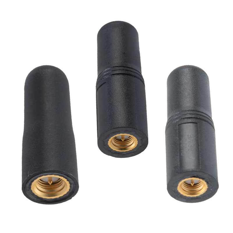
The MIL-STD-810G GPS/GNSS antennas include multi-standard GPS L1, Galileo E1 and GLONASS options and are designed for environmental performance according to the MIL-STD-810G standard.
The antennas are available in passive and active versions and provide coverage from 1,597 MHz to 1,607 MHz. The MIL-STD-810G GPS/GNSS antennas feature linear polarization for cross-polarized isolation, nominal gain options of -3 dBic and 10 dBic, and SMA mounts.
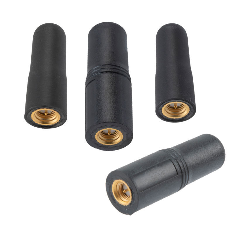
Pasternack has released a series of GNSS antennas that meet military specifications for use in several small form factor and mobile applications.
The mil-spec GNSS antennas are engineered for environmental performance according to the MIL-STD-810G standard and include multi-standard GPS L1, Galileo E1 and GLONASS options.
The MIL-STD-810G GNSS antennas are IP67 rated. They are available in passive and active versions and provide coverage from 1,597 MHz to 1,607 MHz. The GNSS antennas feature linear polarization for cross-polarized isolation, nominal gain options of -3 dBic and 10 dBic, and SMA mounts.
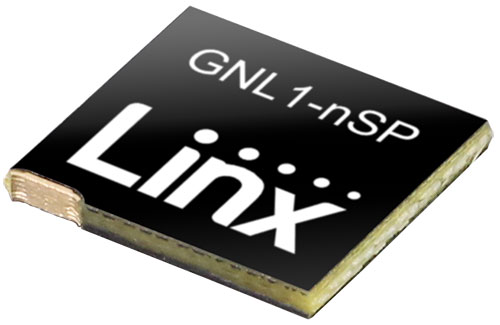
Linx Technologies, now part of TE Connectivity, has expanded on its Splatch antenna series with the release of the ANT-GNL1-nSP, a surface-mount embedded GNSS antenna supporting GPS, Galileo, GLONASS, Beidou and QZSS in the L1/E1/B1 bands.
“The new linear GNSS antenna from Linx expands upon our already robust embedded PCB antenna portfolio of customer favorites like the uSP410, SP610 and the nSP250, by adding a GNSS solution,” said Rick Stuby, vice president of product management. “The antenna displays high performance in a compact surface-mount package, making it especially well-suited for small devices in the growing internet of things market.”
The ANT-GNL1-nSP antenna exhibits notable performance in a compact size (10 mm x 8 mm x 1 mm) and features linear polarization and an omnidirectional radiation pattern. The antenna is available in tape and reel packaging and is designed for reflow-solder mounting directly to a printed circuit board for high-volume applications.
The new GNSS antennas are available now via Linx Technologies’ distributor and manufacturer representative networks. For larger quotes, email Linx Technologies at [email protected].
A roundup of recent products in the GNSS and inertial positioning industry from the November 2022 issue of GPS World magazine.
OEM
GNSS Module
For UAV, precision agriculture and autonomous machines
Photo: Unicore Communications
The UM982 GNSS module is a high-precision, dual-antenna real-time kinematic (RTK) positioning and heading module. It supports BeiDou B1I/B2I/B3I; GPS L1/L2/L5; GLONASS L1/L2; Galileo E1/E5a/E5b, QZSS L1/L2/L5; and SBAS in dual-antenna mode. The highly integrated, compact (16 mm × 21 mm × 2.6 mm) module can reduce the design area of an OEM board by 72% compared to previous modules. Power consumption is less than 0.6 W. The NebulasIV GNSS system-on-chip is a key part of the UM982’s navigation system. The NevulasIV integrates RF, baseband and high-precision algorithms on a single chip, with supporting functions built in. High-level performance indicators include raw observation accuracy, RTK positioning accuracy, precise point positioning accuracy, and time to first fix. The two antennas can independently participate in deriving an RTK solution and outputting the positioning results.
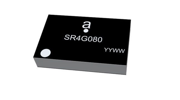
Alternative to ceramic patch provides omni-directional performance
Photo: Antenova
The Agosti (part number SR4G080) is a new miniature surface-mount-designed (SMD) antenna for GNSS applications. It measures 9.0 mm x 5.8 mm x 1.7 mm and operates with exceptional efficiency in a reduced space on a corner of a printed circuit board. It has a small ground-plane requirement of 40 mm x 20 mm, 70 mm x 25 mm and 80 mm x 30 mm, making it suitable for small form-factor designs such as wearable devices, trackers and onboard diagnostics.
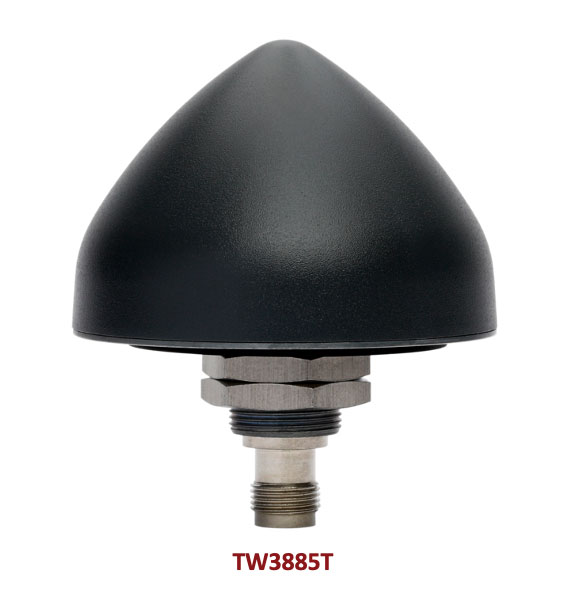
Housed Dual-Band antenna with Accutenna technology
Photo: Tallysman
The dual-band TW3885T antenna supports GPS/QZSS L1/L5; Galileo E1/ E5a/b; BeiDou B1/B2/B2a; GLONASS G1/G3; and satellite-based augmentation systems in the region of operation: WAAS (North America), EGNOS (Europe), MSAS (Japan) or GAGAN (India). It is housed in a through-hole mount, weatherproof (IP69K) enclosure. It mitigates the effects on GNSS receivers of new signals or harmonic frequencies from adjacent LTE bands on the radio-frequency spectrum. For permanent installations, L-bracket (PN 23-0040-0) or pipe (23-0065-0) mounts are available. Tallysman provides an antenna installation guide that recommends a 100 mm –125 mm ground plane and provides antenna installation and cable connector waterproofing best practices.
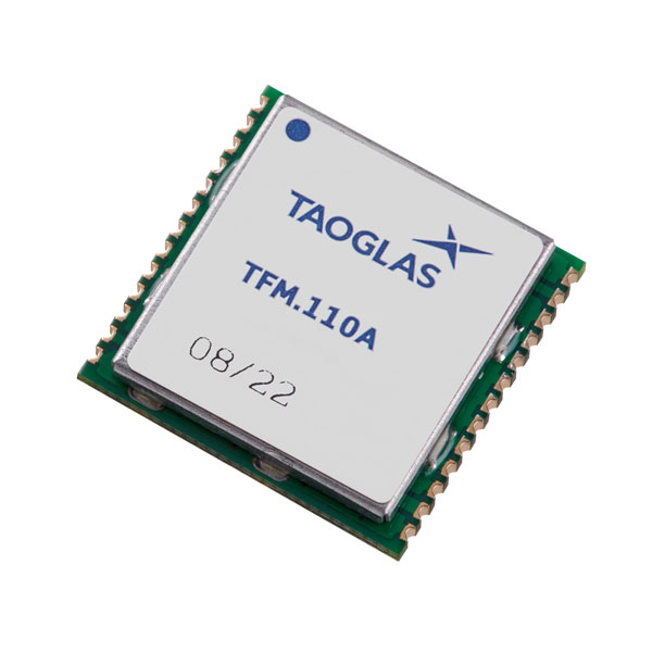
Simplifies product development for high-precision applications
Photo: Taoglas
The TFM.110A is the first in a new series of high-precision, multi-band GNSS front ends for autonomous vehicles, precision agriculture, automotive applications and robotics. It comes fully integrated with two cascaded low noise amplifiers (LNA) and pre-filters in a small, low-profile, shielded surface-mount package. When used between the device’s GNSS receiver and antenna, the two-stage amplifier solution eliminates the need for complex and challenging onboard filter and amplifier circuits. It supports L1, L2 and L5 bands and enables seamless signal transmission, signal purity and position accuracy in high-precision applications.
Provides interference, spoofing, encryption and authentication capability
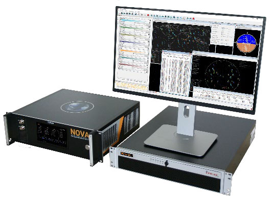
Photo: IFEN GmbH
Version 2.8 of the NCS Nova RF signal simulator offers advanced capabilities. With integrated interference generation capability, the Nova can generate coherent interference signals with a signal power of up to –30 dBm. The ability to assign two users to one RF output enables integrated spoofing scenarios with a single RF output, meaning spoofing is available even with an entry-level single RF Nova. The new release has advanced navigation message authentication simulation capability compliant to User ICD 1.0 for the Galileo E1-B OSNMA, meaning specific OSNMA events can be simulated — key to ensuring compliant receiver behavior. Supported events include renewal and revocation of both a public key and a TESLA keychain. GPS cross-authentication and generation of Galileo E6-C encrypted codes are also supported.
Enables first responders to locate callers on floor levels
Photo: Polaris Wireless
Z-axis location service enables the pinpointing of a smartphone user within one floor level inside a multi-story building. The technology — demonstrated to meet the 3-meter vertical location accuracy requirement of the Federal Communications Commission (FCC) — is integrated into Schok Gear’s newly released flip phones. The Schok phones provide consumers with a simple, powerful device. Adding indoor and vertical location to these phones enables first responders to locate all wireless 911 callers with floor-level accuracy in multi-story buildings.
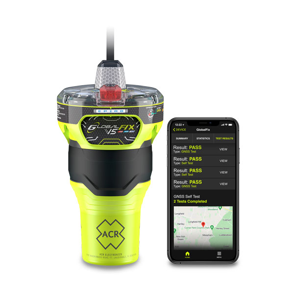
The new ACR Electronics GlobalFix V5 Emergency Position-Indicating Radio Beacon (EPIRB) and ResQLink AIS Personal Locator Beacon (PLB) have integrated the automatic identification system (AIS) to increase the speed of location and aid. They also are compatible with Return Link Service (RLS) alerting. The combination of services ensures faster rescue and increases chance of survival of both boat (EPIRB) and crew (PLB). The safety beacons deliver mobile connectivity to a cell phone with a free mobile app, made possible with the addition of near-field communication technology in the beacons. With the app, users can monitor their beacons, review self-test results, view GNSS test locations, and monitor beacon performance and maintenance by scanning the beacons with their mobile phones. Besides GNSS positioning, the lightweight beacons have 406-MHz Cospas-Sarsat distress signal with MEOSAR compatibility and 121.5-MHz local homing signal.
The Canvas Device Manager simplifies workflows for configuration and maintenance of internet of things (IoT) device deployments. It enables users to easily set up devices, monitor performance, and keep software up-to-date across the entire IoT device fleet. Device parameters can be remotely managed, and performance monitored. Canvas enables users to organize large numbers of devices to quickly build and maintain IoT solutions, and software updates can be remotely and rapidly deployed, thwarting security attacks.
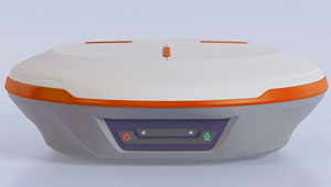
The N2 Palm RTK GNSS receiver is suitable for surveying, mapping and construction. It has a highly integrated main board and a three-in-one antenna, yet weighs 0.72 kg with battery and measures 48 mm. Powered by ComNav’s SinoGNSS K8 high-precision module, the N2 can track 1,590 channels, including all existing and planned signals of GPS, BDS-2, BDS-3, GLONASS, Galileo, QZSS and SBAS. Its advanced satellite-tracking technology ensures it works well even in harsh environments, such as under heavy foliage or close to buildings. A third-generation inertial measurement unit (IMU) makes the N2 immune to magnetic disturbance, which greatly improves its reliability. Pole-tilt compensation of up to 60° allows surveyors to locate points within 2.5 cm. By using the company’s Quantum algorithm, the N2 achieves calibration-free operation — after 10 seconds of initialization, users can make tilt measurements with centimeter-level accuracy for an extended period, greatly improving efficiency.
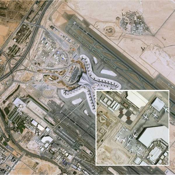
Airbus has added 30-cm Pléiades Neo imagery to its OneAtlas Living Library service. The new data source will complement the service which already allows users to instantly access a premium catalogue of Pléiades 50 cm and SPOT 1.5 m data via streaming, download and API. The Living Library provides frequent updates over urban areas, airports, harbors and military sites to name a few. Imagery is updated every day and processed in the cloud, with flexible options for integration into GIS workflows. With the OneAtlas Living Library, Airbus offers a pay-per-order option but also a subscription-based service that allows users to access premium content quickly available into their account, as well as a deeper archive of more than 10 years of imagery by Pléiades and SPOT satellites at a higher incidence angle and cloud coverage threshold, which will be available in just a few hours. OneAtlas also provides access to several other data services, such as reactive tasking, that allows users to task a full suite of optical and radar satellites, including Pléiades Neo, or access more than 15 years of global radar data, as well as the ability to download the WorldDEM product suite among others.
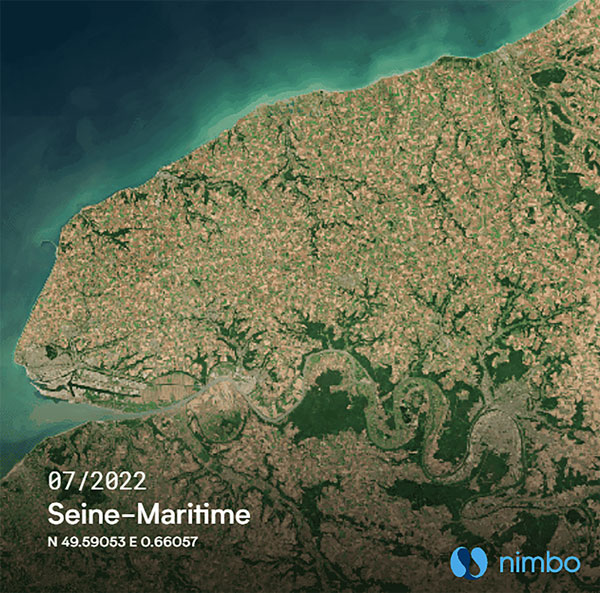
Free, user-friendly tool shows the Earth’s changes
Photo: Kermap
The Nimbo Maps platform provides monthly 10 m-resolution images of changes on Earth in a user-friendly format. The images are chronological, seamless and free of clouds, and include intuitive comparison timelapse features. The platform, developed by French startup Kermap, relies on innovative artificial intelligence methods to process satellite images supplied by the European Union’s Copernicus program through its Sentinel missions. APIs automatically retrieve data extracted from satellite imagery, providing Kermap customers with real-time, strategic, value-added information in the fields of agriculture, land planning and environmental transitions. Current coverage includes Europe, the Middle East and the United States, with plans to provide global coverage by early 2023.
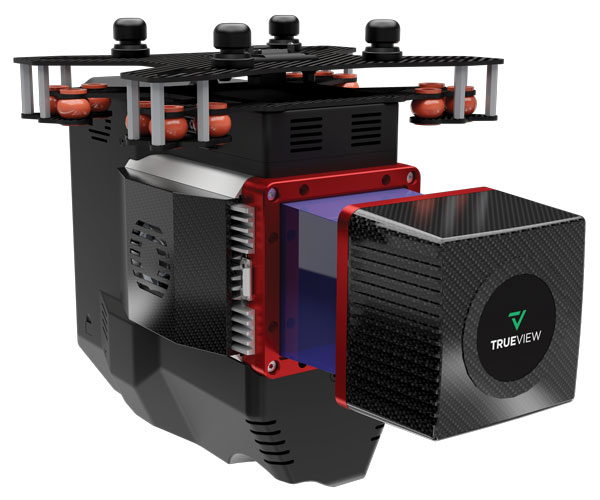
The TrueView 655/660 3D imaging system uses the Riegl miniVUX-3UAV laser scanner and three fully integrated mapping cameras (right, left and nadir) for high-accuracy mapping with excellent vegetation penetration and wire detection. Previous TrueView 3D systems carried dual oblique cameras to maximize mapping coverage. The TrueView 655/660 adds a third RGB camera, allowing for imagery directly below the sensor to be captured. The third camera provides a direct view of the ground below to maximize data collection for time flown, while improving the quality of photogrammetry and colorized point clouds.
InfiniDome has released GPSdome 2, its newest anti-jamming solution. The cost-effective and lightweight device provides simultaneous dual-frequency protection from three directions of attack.
GPSdome 2 is a high-end solution tailored to defend small- to medium-sized tactical UAVs as well as manned and unmanned ground vehicles.
Disruptions in critical positioning, navigation and timing (PNT) data mean loitering munitions that never find their targets, UAVs that fall to the ground, and ground vehicles that cannot be managed.
With a small form factor (500 g, 87 mm x 91 mm x 61.55 mm) and minimal power consumption, GPSdome 2 is suitable for loitering munitions as well as drones and UAVs, increasing resiliency while prolonging mission time and providing a superior return on investment. Fully retrofit and completely standalone, the system is compatible with almost any off-the-shelf GNSS receiver on the market as well as standard active GNSS antennas, meaning that it can be integrated into existing GPS systems or into new product lines, manned or unmanned.
With sophisticated algorithms and a proprietary RFIC, GPSdome 2 analyzes RF interference in the environment and combines multiple antenna patterns to create and dynamically steer three nulls in the direction of any hostile signal.
GPSdome 2 provides simultaneous dual-frequency protection (GPS L1 + L2 or GPS L1 + GLONASS G1), creating up to three nulls, protecting from three jamming directions within each band in real time, making it suitable for PNT applications.
The GPSdome 2 is a dual-use, non-ITAR device and comes with optional mil-spec compliance. It has been chosen by an Israeli defense contractor for integration with its platforms.
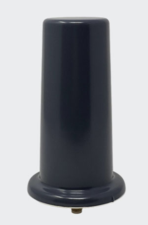
Tallysman Wireless has added the housed AJ977XF triple-band antenna with anti-jam technology to its line of GNSS products.
According to Tallysman, the AJ977XF uses a novel stacked antenna phased array that creates a null of typically 20-dB attenuation in the antenna’s radiation pattern from the horizon to an elevation angle of approximately 15 degrees.
The null in the radiation pattern strongly mitigates in-band and out-of-band signals. For example, the AJ977XF will continue to function in the presence of a ground-level 600-watt jamming signal, 100 meters or greater from the antenna. In addition to the null in the radiation pattern, the antenna’s OP1dB (compression point) is 15 dBm, which strongly protects the antenna’s low-noise amplifier (LNA) from saturating.
The triple-band AJ977XF antenna supports GPS L1/L2/L5, GLONASS G1/G2/G3, Galileo E1/E5ab and BeiDou B1/B2ab), and, in the region of operation, satellite-based augmentation systems (SBAS): WAAS (North America), EGNOS (Europe), MSAS (Japan), or GAGAN (India).
The AJ977XF is housed in a through-hole mount, weatherproof (IP67) enclosure. L-bracket (PN 23-0040-0) or pipe (23-0065-0) mounts are available for permanent installations.
The radio frequency spectrum has become congested worldwide as many new LTE bands have been activated. Their signals or their harmonics can affect the proper operation of GNSS antennas and receivers.
In North America, the planned Ligado service, which will broadcast in the frequency range of 1526 to 1536 MHz, can negatively affect the reception of GNSS signals. Similarly, new LTE signals in Europe [band 32 (1452–1496 MHz)] and Japan [bands 11 and 21 (1476–1511 MHz)] also have been shown to affect GNSS signal reception. Tallyman’s new AJ977XF mitigates the effects of these new signals.
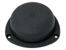
Tallysman Wireless has added the housed SSL990XF full-band survey-grade GNSS antenna to its line of GNSS products.
The SSL990XF uses a derivative of Tallysman’s patented VeroStar antenna element to provide full GNSS + L-band corrections frequency coverage.
The SSL990XF is 63 mm in diameter and 28 mm tall and weighs ~50 grams, making it a very small and light housed full-band precision antenna. It has a very tight average phase-center variation of 4 mm or lower for all frequencies and overall azimuths and elevation angles.
The full-band SSL990XF antenna supports GPS/QZSS L1/L2/L5, QZSS L6, GLONASS G1/G2/G3, Galileo E1/E5ab/E6 and BeiDou B1/B2ab/B3, as well as L-band correction services. Also supported in the region of operation are satellite-based augmentation systems: WAAS (North America), EGNOS (Europe), MSAS (Japan), or GAGAN (India).
The SSL990XF is housed in a weatherproof (IP67) enclosure and is mounted using either adhesive tape or a mounting collar that includes a waterproofing O-ring. Two antenna cable connector options are available. The first is a female SMA, and the second is an MCX. It is an ideal antenna for precision UAV and all applications where light weight and precision matter.
The radio-frequency spectrum has become congested worldwide as many new LTE bands have been activated, and their signals or harmonic frequencies can affect GNSS antennas and receivers.
In North America, the planned Ligado service, which will broadcast in the frequency range of 1526 to 1536 MHz, can affect GNSS signals. Similarly, new LTE signals in Europe [Band 32 (1452–1496 MHz)] and Japan [Bands 11 and 21 (1476–1511 MHz)] have also affected GNSS signals. Tallyman’s new SSL990XF with eXtended Filtering (XF) technology mitigates the interference effects of these new signals.
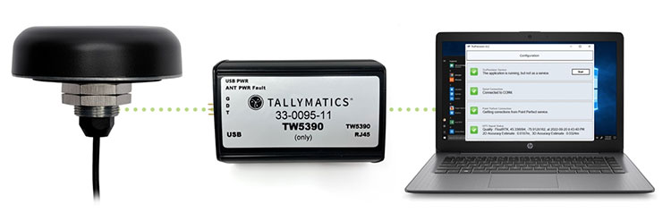
Tallymatics has introduced the TW5390 smart antenna with IP network and L-band augmentation service capability.
Tallymatics is a division of Tallysman Wireless, a Calian company, specializing in of precision geolocation applications and equipment.
To create the TW5390, Tallymatics leveraged its experience in GNSS applications, design and manufacturing, combining Tallysman’s GNSS antenna technology with the high-precision u-blox F9R GNSS receiver and DS9 L-Band receiver modules.
The combination delivers a reliable and convenient smart antenna yielding <6 cm accuracy, with precise point positioning/real-time kinematic (PPP/RTK) augmentation services via the PointPerfect subscription service.
The TW5390 solves the complexities of GNSS design — it sends the host system PPP/RTK corrected coordinates in NMEA format over a robust RS-485 interface, assuring results that meet customers’ high expectations.
Features of the TW5390
simultaneous dual-band coverage for GPS, Galileo, GLONASS and BeiDou
superior multipath rejection with Tallysman Accutenna technology
low noise amplifier
Tallysman’s eXtended Filtering (XF) technology, which mitigates saturation from nearby RF signals (targeting
LTE and Ligado)
tight, measured phase-center offset and low axial ratio, enabling accurate and precise positioning
direct decoding of PointPerfect, SPARTN formatted augmentation packets (u-blox specific)
IP network and L-band augmentation communications channels
built-in inertial measurement unit for UDR and ADR
fast convergence time of 40 seconds (PPP/RTK) with < 6 cm accuracy
IP69K package
RS-485 transceivers
Tallymatics SDK available with computer interface, TruPrecision software and 60 days of free PointPerfect
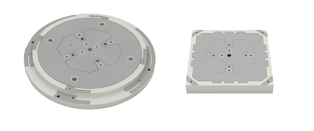
SABIC, a global leader in the chemical industry, has introduced two new LNP Thermocomp compounds that offer the potential to improve signal gain performance compared to ceramics in second-generation automotive GNSS antennas.
The new compounds, LNP Thermocomp ZKC0CXXD and LNP Thermocomp ZKC0DXXD, help enable the design and molding of antenna substrates with more complex pattern markings that add effective surface area, a critical factor in enhancing signal capture.
For customers that use ceramics, switching to the LNP Thermocomp compounds can help lower system costs by avoiding secondary operations, as well as improving antenna performance. Designers and engineers who find current materials inadequate for developing novel, high-resolution GNSS antennas can help address new requirements with the SABIC products, the company said.
“As GNSS antenna technology advances to its second generation with higher resolution, SABIC continues to enhance the scope and capabilities of our LNP specialty compounds portfolio to meet new performance requirements,” said Joshua Chiaw, director of business management, LNP, SABIC. “Our new LNP Thermocomp compounds can help antenna manufacturers achieve superior signal gain compared to ceramic substrates. They also provide flexibility to produce smaller parts with the same performance as ceramic, or equal-size parts with better performance. This remarkable combination of improved signal capture and design freedom, plus system cost advantages, can help propel innovation in GNSS technology — a keystone of occupant safety today and autonomous driving in the future.”
The LNP Thermocomp compounds, which offer a high dielectric constant (Dk) for miniaturization and a low dissipation factor (Df) to facilitate signal acquisition, can be tailored to meet the electrical requirements of individual applications. They feature electroplating capability, good thermal resistance for reliability, and the design freedom and production efficiency of thermoplastics. Both are well-suited for shark fin-style and new conformal antenna designs.