PCTEL Inc. has launched a new GNSS multi-satellite antenna portfolio for mobile and base-station timing applications. PCTEL’s new SkyLink antenna technology features out-of-band rejection characteristics that provide exceptional GPS/Galileo and GLONASS L1 support and performance in heavy RF traffic environments for fixed and mobile timing and asset tracking applications.
The new portfolio consists of two product lines:
SkyCompass for fleet management and asset tracking applications
SkyStamp base-station antennas for timing and synchronization of 4G LTE cellular networks.
SkyCompass comprises six new configurable antenna platforms, including single-band or multiband GNSS options that address the majority of fleet management installation needs. SkyStamp offers two timing reference and synchronization antenna models that provide maximum mitigation of the effects from nearby LTE interference sources.
“Over the last decade, PCTEL has been the industry’s technology leader in high rejection GPS products. These antennas are deployed worldwide by OEM customers in aviation, defense, and fleet management public safety projects,” said Rishi Bharadwaj, vice president and general manager of PCTEL’s Connected Solutions. “True to our commitment to support global communications and evolving requirements, PCTEL’s SkyLink technology provides global multi-satellite GNSS coverage and precision tracking by rejecting RF noise or interference that can negatively affect communications in performance critical situations.”
SkyCompass and SkyStamp antennas will be available for shipment in November.
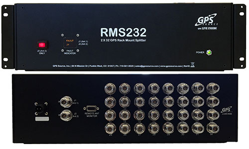
GPS Source has released a GPS/GNSS rackmount splitter with dual antenna inputs and antenna health monitoring. Developed for the wireless industry, the dual-input splitter provides a GPS timing signal to up to 32 GPS/GNSS synchronization modules and receivers. Its design ensures the GPS timing signal is always available, even in the event of an antenna or cable failure, the company said.
Like GPS Source’s GPS rackmount splitters, the new rackmount splitter amplifies and splits the GPS/GNSS signal. However, the new splitter also includes dual GPS antenna input ports, a health monitor and sensor switch. Up to 32 GPS/GNSS receivers or timing synchronization modules can access the signal at one time. Antenna redundancy is acquired through the use of primary and backup antennas. The sensor monitors the health of the primary antenna connected to the splitter. Based on the information provided by the sensor, the splitter will automatically switch antennas. The ability of the splitter to switch antennas allows all connected GPS devices to remain fully functional in the event of an antenna failure, which is important in today’s wireless environment.
“The demand for high-speed wireless internet and data network access over a wide area has grown at a record pace,” said Robert Horton, CEO of GPS Source. “This growth has led to a strong demand for solutions that support more than one function because of limited space and increased usage. The new rackmount splitters, RMS216 and RMS232, will keep multiple timing synchronization modules operating for an extended period when a GPS antenna or cable fails. This extended period gives a solution provider supporting a cell site, base station, or DAS network, the ability to identify and fix any GPS/GNSS antenna or cable problem before other challenges arise.”
The R2 GNSS receiver works with Trimble handheld devices and iOS, Android or Window mobile handhelds, smartphones and tablets using Bluetooth or USB connectivity. When paired with a mobile device, the receiver adds professional-grade GNSS capabilities for better accuracy. The rugged Trimble R2 provides GIS and survey professionals the flexibility to choose the mobile device, workflows and accuracy they need based on applications.
The Trimble R2 GNSS receiver is compact and portable, weighing 2.4 pounds. With one button operation and field swappable battery, the receiver can be pole or vehicle mounted or carried on a backpack. The R2 is a multi-constellation receiver that supports GPS, GLONASS, Galileo, BeiDou and QZSS satellite signals as well as SBAS.The Trimble R2 can achieve sub-meter to centimeter positioning.
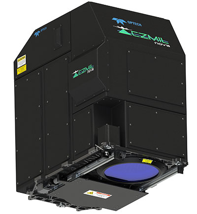
The Optech CZMIL Nova airborne bathymetric mapping system.
Coastal and Marine Mapping
The Optech CZMIL Nova airborne bathymetric mapping system is designed for coastal and marine mapping.With a powerful yet efficient laser, it maps deeper while flying higher, reaching depths of 80 meters in clear waters. The enhanced design and automated processing tools produce simultaneous high-resolution 3D data and imagery of the beach and shallow water seafloor, including coastal topography, bathymetry, benthic classification and water column characterization. Its bathymetric lidar is integrated with a hyperspectral imaging system and digital metric camera. Optech HydroFusion, an end-to-end software suite, handles data from all three sensors.
The latest generation Leica Viva GS14 GNSS receiver now supports Verizon CDMA solutions along with all standard 2G/3G networks and UHF TX/RX radio in a single device, making it a professional GNSS receiver with all three communication systems built in. Users simply slide in their SIM card to experience instant connectivity for faster and easier field communications and SmartNet RTK corrections. No external equipment is required.
The VeraPhase 6000 family of antennas provides the lowest axial ratios (horizon to horizon, through all azimuths) across all GNSS frequencies (70 percent), a tight PCV (± 1mm through all frequencies, azimuths, and elevations), and a consistent PCO through all frequencies.
The performance of the VeraPhase rivals that of choke ring antennas, but is much lighter, smaller and more economical. The antenna family is designed for use in survey, precision RTK and reference antenna applications.
The VeraPhase 6000 also provides an available PCB within the base of the antenna for integration of a custom system board such as a dual-band or RTK GNSS receivers or other applications.
The GIS 2go Cadenza software suite for mobile GIS visualizes geodata and attribute data for efficient result presentation. This version offers new features for tablet or smartphone, allowing users to transfer maps from Cadenza or ArcGIS for Desktop to mobile devices for use offline and availability to others via the cloud, creating an extended field workstation. The mobile app also features faster exporting and optimized use of land registers for geometry and attribute editing in the field.
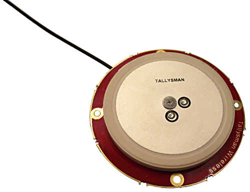
Tallysman, a manufacturer of high-performance GNSS antennas, announces the commercial availability of the VeraPhase 6000 antenna series, a family of antennas that provides the lowest axial ratios (horizon to horizon, through all azimuths) across all GNSS frequencies (70 percent), a tight PCV (± 1mm through all frequencies, azimuths, and elevations), and a consistent PCO through all frequencies.
The performance of the VeraPhase rivals that of choke ring antennas, but is much lighter, smaller and more economical, Tallysman said. The antenna family is designed for use in survey, precision RTK and reference antenna applications.
The VeraPhase 6000 also provides an available PCB within the base of the antenna for integration of a custom system board such as a dual-band or RTK GNSS receivers or other applications.
The VP6000 family provides high receive RHCP gain over the full GNSS spectrum:
low GNSS band (1164 MHz to 1300 MHz)
L-band correction services (1525 MHz to 1559 MHz)
high GNSS band (1559 MHz to 1610 MHz).
Each model features a robust, high IP3, pre-filtered LNA to minimize desensing from high-level out-of-band signals, including 700 MHz LTE, and that yet still provides a noise figure of less than 2.5 dB. Non-pre-filtered versions are also available with a noise figure of less than 1.5 dB.
The VP6000 antenna family is available in three formats:
A survey-grade all-band antenna that provides 35-dB LNA gain and is available with a robust rubber bumper for field use.
An all-band base station antenna is available with 35-dB LNA gain or with an internal 15-dB pre-filtered pre-amp for OEM applications.
An all-band reference antenna that features a 50-dB gain LNA, a conical radome to shed snow ice and birds, and is available with a robust monument mount for sub-millimeter precision.
Each antenna has a well defined phase centre offset relative to the antenna reference plane.
The base housing of the VP6000 is IP67-compliant and weighs less than 700 grams. The antenna is 167 millimeters wide at the top, 110 millimeters wide at the base and 110 millimeters in height. Each model has a 5/8-inch x 11 TPI thread for mounting and is available with either a TNC or an N-type connector.
Leica Geosystems, manufacturer of the Leica Viva GNSS Unlimited series and GS14 GNSS receiver, has added a new hybrid communication technology to its compact and powerful GNSS smart antenna. The latest generation Leica Viva GS14 GNSS now supports Verizon CDMA solutions along with all standard 2G/3G networks and UHF TX/RX radio in a single device, making it a professional GNSS receiver with all three communication systems built in. Users simply slide in their SIM card to experience instant connectivity for faster and easier field communications and SmartNet RTK corrections, the company said.
The Leica Viva GS14 3.75G&UHF supports 2G GPRS, 3G HSPa+, CDMA (EV DO) and UHF TX/RX radio between 450 and 470 MHz in one compact housing. Professionals can choose whether they want to use the UHF radio to transmit or receive work, a 2G/3G cellular network, or Verizon CDMA. No external equipment is required.
“The Leica Viva GS14 with its hybrid communication technology is the most advanced compact GNSS receiver in the market,” said Bernhard Richter, Leica Geosystems GNSS business director. “The addition of CDMA modem capability in a unique all-in-one design offers unmatched flexibility in communication choices.”
The Leica Viva GS14 3.75G&UHF is available today throughout the United States. Ordering information and details are available from all authorized U.S. Leica Geosystems representatives and dealers.
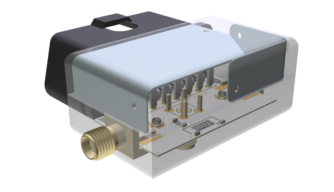
The Antenova ODB (on-board devices) design fully assembled.
Antenova Ltd., manufacturer of antennas and RF antenna modules for M2M and the Internet of Things, has built a model design for on-board devices (OBD) and vehicle telematics, which the company will be showing at CTIA Supermobility 2015.
The OBD design uses three new antennas inside an OBD housing to link to GNSS satellite, Bluetooth and a terrestrial network, while obtaining optimum performance from all three antennas simultaneously. The design also features a new small GNSS RF module to fix location, which Antenova is showing for the first time.
Antenova is using the latest antennas from it product ranges in the OBD design:
the Armata 3G FPC antenna for penta-band frequencies which operates at 824-960 MHz and 1710-2170 MHz
a new GNSS antenna named Bentoni operating at 1559-1609 MHZ,
the tiny Weii PCB-mounted antenna, which provides a Bluetooth connection at 2.4GHZ.
All three are new antennas Antenova released this year.
The new GPS/GNSS module (Antenova part number M10578) is a complete receiver that provides accurate location tracking for OBDs. It uses the latest MediaTek chipset with an additional LNA to give added performance when mounted under dashboards and out of line of sight with the sky.
Antenova’s product designers recently introduced the concept of “Design For Integration” (DFI), which considers how the RF antenna will operate when it is embedded with a manufacturer’s product. Antenova’s antennas are always used within a customer’s design, so they are designed to provide superior RF performance from within the device, and to make the integration of the RF elements easier for the designer. In addition to this, Antenova provides its customers with technical support during the design, integration and testing phases.
“We are demonstrating how a design for an OBD can give great performance, even when new antennas are added to an existing design,” explained Colin Newman, Antenova’s managing director. “OBD devices are growing fast in popularity, and the design of the RF components is critical to the overall performance of a device. In particular, Antenova’s engineers have invested many years in designing antennas that work effectively in very small spaces, whilst maintaining the efficiency of the antenna.”
Antenova offers a range of antennas for Bluetooth, ZigBee, Wi-Fi, ISM, 802.11, 3G, GSM, GPRS, Edge, UMTS, WCDMA, LTE, GLONASS, BeiDou and Gallileo.
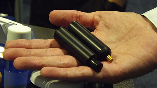
PCTEL’s GPS/GLONASS high-performance asset tracking and synchronization helix antennas are now available commercially. The antennas capture the frequencies needed for GPS, Galileo and GLONASS satellite reception. This cross-compatibility allows global OEMs to use one standard platform to serve both European and U.S. markets.
PCTEL will display its new IP67-rated GEO-GNSS antennas and other mobile and GPS antennas Sept. 16-17 at ION GNSS+, Booth #416.
PCTEL uses its proprietary filtering design to allow wideband coverage while achieving superior out-of-band rejection, the company said. The small form-factor helix antennas will withstand harsh environments.
“Customers expect PCTEL to solve challenging problems,” said Rishi Bharadwaj, PCTEL’s vice president and general manager, Connected Solutions. “We designed PCTEL’s GEO-GNSS series for complex asset tracking and network timing applications.”
For more information about PCTEL’s GEO-GNSS helix antennas, visit the PCTEL website.
Technology Advancement Group (TAG) will be showcasing precision, navigation and timing technology integration solutions at the ION GNSS+ conference, which will be held Sept. 14-15 in Tampa, Fla.
In particular, TAG will display a custom-designed military GNSS survey system that is the U.S. Army program of record for geodetic, construction and airfield surveying.
TAG’s Precise Positioning Service Global Positioning System Survey (PPS GPS-S) system was designed specifically for use by survey teams to have access to centimeter-level GPS survey accuracy with the added benefits of a fully-certified military GPS receiver that is supplemented with a GNSS receiver for real-time kinematic surveying with multi-constellation operations.
The PPS GPS-S system has been specifically designed to address the stringent requirements of military survey missions including geodetic, construction, airfield, and field artillery survey. It gives the military surveyor the tools they need to complete their missions with minimum time-on-station even in the face of GPS signal interference, attempted spoofing, or electronic warfare, the company said.
TAG was recently awarded a $24 million contract by the U.S. Army Geospatial Center for its AN/GSN-16 military survey system.
Core components of the PPS GPS-S system include a base station and two rovers, each integrated with a GNSS antenna with protection against jamming or spoofing, a custom-designed rugged tablet with an internal RF radio that has a 20-km range, and GPS-S accessories for additional functionality. Designed for continuous operation, the PPS GPS-S system includes multiple power options such as dual hot-swappable Li-Ion batteries, 12V battery, DC/DC converter, NATO adapter, and 4-slot Li-Ion charging station.
Powered by Carlson Surv-PC, TAG’s PPS GPS-S system is tailored for military environments that require tactical computer-aided design (CAD) operations. With an intuitive graphical user interface, surveying operations can be conducted in the field allowing for work to be completed in real-time. Accurate geospatial information system (GIS) data capture and a full suite of CAD functions allows survey teams to remain in the field to complete the drawings without the need to return to base.
For ION GNSS+, TAG will be in booth #102 of the exhibit hall in the Tampa Convention Center.
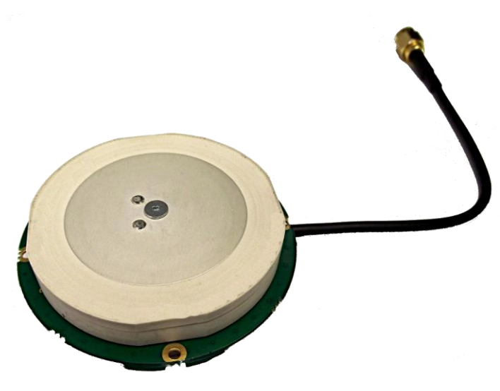
Tallysman, a manufacturer of economical high-performance GNSS antennas, has announced a new series of L1 band Accutenna wideband antennas for OEM applications. The antennas are offered in three formats for reception of GPS; GPS + GLONASS; or Galileo + GPS + GLONASS + BeiDou.
Each antenna type features Tallysman’s Accutenna technology, which provides high rejection of multi-path signals, with low axial ratios, and tight Phase Center Variations (PCV). Each is available with a brickwall pre-filter option to protect against saturation by high level sub-harmonic and L-Band signals.
Here are what each antenna in the new line covers:
The TW2106 is designed to receive GPS L1. TW2108 is the brick-wall pre-filtered version.
The TW2406 is designed to receive GPS + GLONASS. TW2408 is the brick-wall pre-filter version.
The TW2706 is designed to receive all of Galileo, BeiDou, GPS + GLONASS. TW2708 is the brick-wall pre-filter version.
The antenna PCBs are each 56 mm in diameter with four plated holes for secure mounting. They are available with a variety of connectors and custom cable lengths. The antennas can be custom tuned to ensure optimal performance within customers’ enclosures. All of them are REACH and ROHS compliant.
INTERGEO Announcement
At INTERGEO in Stuttgart, Tallysman will be announcing the availability of patented new GNSS antenna technology that it said is proving to:
Produce the lowest axial ratios from horizon to horizon through all azimuths and across all GNSS frequencies
Produce sub-millimetre Phase Centre Variation (PCV) through all elevations, all azimuths, and across all GNSS frequencies
Be lighter weight, smaller size, and more economical than other reference and geodetic antennas
Have the unique feature of having room within the antenna base to house customers’ circuitry.
Tallysman’s booth at INTERGEO will be in Hall E8, Booth 038. Follow GPS World on Twitter for the latest news from INTERGEO.
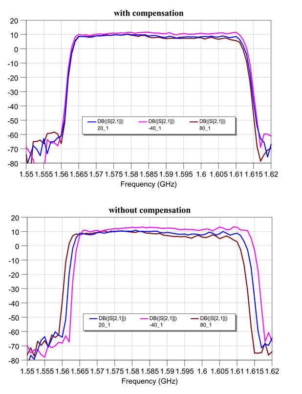
Tallysman, a manufacturer of high-performance GNSS antennas, has launched a higher gain dual-frequency embedded antenna: the TW3870E. The TW3870E antenna has a typical gain of 35 dB which is required by some GNSS receivers, such as Trimble’s BD9xx family of receivers.
The antenna is capable of receiving GPS L1/L2 and GLONASS G1/G2 signals. It employs Tallysman’s Accutenna technology, which can provide low axial ratios, high multi-path signal rejection, low noise, tight PCV and a phase linear response.
The TW3870E is 60 mm in diameter and has four drilled plated holes for secure mounting within customers’ products. The antenna can be custom tuned to ensure optimal performance. Custom cable lengths and connectors are also available.
The antenna is REACH and ROHS compliant.
Visit Tallysman’s booth at INTERGEO 2015, Hall E8, Booth 038 to learn more about the TW3870E and other Tallysman antennas.
The GrAnt by JAVAD GNSS is a versatile high-performance antenna.
With J-shield — the JAVAD GNSS filter that protects GPS L1, Galileo L1 and GLONASS L1 bands — the GrAnt antenna can track GPS, GLONASS, Galileo, BeiDou, WAAS, EGNOS, MSAS, GAGAN and QZSS signals. J-shield brings in all the useful signals intact and rejects out-of-band signals with the slope of about 12 dB/MHz. Similarly, the filter protects GPS L2, GPS L5, GLONASS L2, GLONASS L3 and Galileo L5, and has slope of about 9 dB/MHz. The filters have been extensively tested with five different innovative tests that prove that the filters also improve the performance of GNSS receivers.
The GrAnt antenna can be mounted on flat surfaces with four screws or mounted on standard poles (5/8-11 or 1-14 inch thread). The antenna cable can be connected via the standard TNC (N-type optional) connector on its side or routed through the center of the antenna for ultimate protection in harsh environments.
An optional ground plane can be purchased to increase multipath mitigation.
The top-level model, the GrAnt-G5T, supports a wider band to accommodate additional signals, with frequencies of 1555-1610 MHz and 1164-1300 MHz. Full signal capability of the GrAnt-G5T is:
Antenova Ltd., manufacturer of antennas and RF antenna modules for M2M and the Internet of Things, has announced a new embedded GNSS antenna named Sinica, which operates on the 1559-1609 MHz satellite bands. The Sinica antenna uses a novel design approach and new materials to achieve high performance from an ultra low-profile antenna, Antenova said.
Sinica is suitable for all positioning applications on the 1559-1609 MHz bands. It operates with all of the public satellite constellations — GPS, GLONASS, Baidou and Gallileo — which means it can provide accurate positioning combined with global coverage.
The Sinica antenna is created from FR4 materials and new dielectric constant laminate substrates. It uses a new approach to antenna design, which has enabled the company to create an antenna with the high performance of a ceramic patch antenna, in a low profile part that can be placed neatly within a small printed circuit board, Antenova said.
Sinica is designed for devices that need accurate positioning or tracking globally, which means it is suitable to use in drones, network devices and wearable electronics, or any other portable device or tracking application.
Antenova’s product designers recently introduced the concept of “Design For Integration” (DFI), which considers how the antenna will operate when it is embedded with a manufacturer’s product. Antenova’s antennas are used within a customer’s design, so they are designed to provide superior RF performance from within the device, and to make the integration of the RF elements easier for the designer, the company said. In addition to this, Antenova provides its customers with technical support during the design, integration and testing phases.
Earlier this year, Antenova announced three new families of antennas for the fast growing M2M, wireless and IoT sectors. Sinica belongs to the lamiiANT family of new antennas for these market sectors.
The antennas are supplied on tape and reel and are available through distributors worldwide. Go to www.antenova-m2m.com for more details, or to request an evaluation board for the Sinica antenna.